Fact Sheet 2009–3042
|
The effects of the use of agricultural chemicals and other practices associated with agriculture on the quality of streams and groundwater is well known; however, less is known about how those effects may vary across different geographic regions of the Nation. Scientists at the U.S. Geological Survey (USGS) are conducting studies on the transport and fate of agricultural chemicals in diverse agricultural settings across the country using comparable and consistent methodology and study designs (fig. 1; Capel and others, 2004; Capel and others, 2008). Assessments in five study areas have been completed, and the results highlight how environmental processes and agricultural practices interact to affect the movement and transformation of agricultural chemicals in the environment. The studies address major environmental compartments, including surface water, groundwater, the unsaturated zone, the streambed, and the atmosphere, as well as the pathways that interconnect these compartments. The study areas represent major agricultural settings, such as irrigated diverse cropping in the West and corn and soybean row cropping in the Midwest and, therefore, findings are relevant throughout much of the Nation. Major FindingsFindings from these studies show how environmental processes and agricultural practices act together to determine the transport and fate of agricultural chemicals in the environment. Selected highlights from USGS studies featured in the Journal of Environmental Quality are presented here:
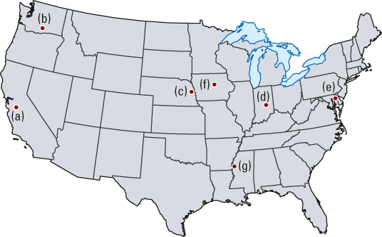
Figure 1. Research was conducted in five study areas: (a) Lower Merced River basin, California; (b) Granger Drain basin, Washington; (c) Maple Creek basin, Nebraska; (d) Sugar Creek basin, Indiana; and (e) Morgan Creek basin, Maryland. Similar studies are underway in two additional study units: (f) South Fork Iowa River basin, Iowa, and (g) Bogue Phalia basin, Mississippi. Characteristics of the Study AreasThe studies were designed at nested scales with most work conducted within a focus watershed nested within a larger study basin (table 1). Each study basin was nested within a larger study unit where previous investigations have been conducted by the USGS National Water-Quality Assessment Program (Capel and others, 2004). Table 1. Drainage areas for study basins and focus watersheds.
The California and Washington study areas (fig. 1) are characterized by semiarid to arid climates and, in both, more than 95 percent of crops are irrigated. The sources of irrigation water in these two areas, however, differ substantially. Most irrigation water in the California study area is pumped from deep groundwater, whereas in the Washington study area an extensive network of water delivery canals distribute surface water from the Yakima River. Agriculture comprises predominantly orchards, vineyards, row crops, dairies, and cattle feedlots in both study areas. The study areas in Nebraska, Indiana, and Maryland (fig. 1) are characterized by humid climates, each receiving 30 to 40 inches of precipitation each year. These three study areas are dominated by corn and soybean row cropping, but several differences exist that can affect the movement of agricultural chemicals. Specifically, irrigation is used to augment water needs in the Nebraska study area, where 30 percent of the farmland is irrigated from deep wells. Subsurface drains, used to move excess water from the root zone, are widely used in the Indiana study area, where topography is flat and soils are relatively high in clay content. In contrast, soils in the Maryland study area are permeable and well drained, and precipitation and natural soil drainage are adequate for agricultural activities. 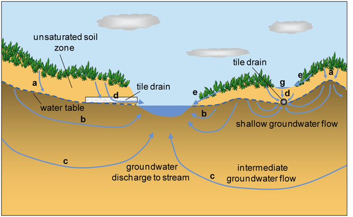
Figure 2. Various relatively short flow paths may connect agricultural fields to streams in areas where the water table is shallow: (a) infiltration to shallow groundwater, (b) shallow groundwater flow, (c) intermediate groundwater flow, (d) seepage to tile drains, and (e) overland flow, which may result in (g) temporary ponding. 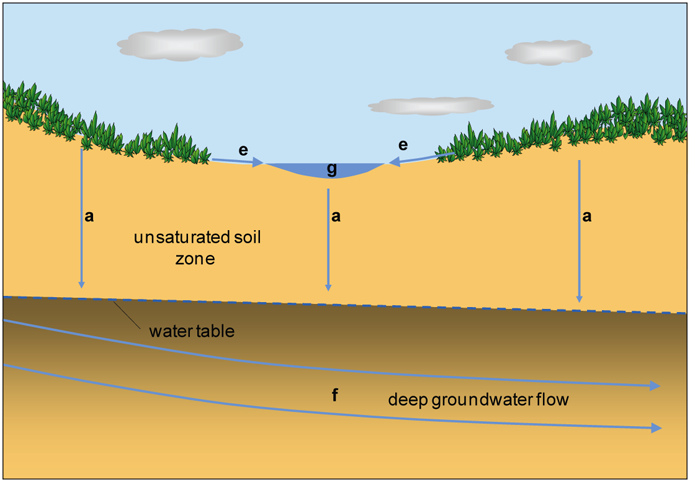
Figure 3. Many flow paths from agricultural fields may bypass local streams in areas where the water table is deep: (a) infiltration to deep groundwater, (e) overland flow to (g) temporary ponds, and (f) deep groundwater flow.
Hydrology Is KeyAn accounting of local hydrology—the amount of water that enters the watershed, moves within the watershed, and leaves the watershed—formed the foundation for understanding the movement of agricultural chemicals in each of the focus watersheds. Stream hydrographs, which show the amount and timing of surface water flowing out of each of the focus watersheds, illustrate some of the large differences in hydrology among these five study areas (fig. 4). Despite similarities in climate and cropping systems at the California and Washington sites (figs. 4A and 4B), differences in irrigation practices have resulted in large differences in streamflow at the catchment outflows. Long-term irrigation from groundwater has lowered the water table substantially in the Mustang Creek catchment, increasing the distance between the stream and the underlying groundwater system. Groundwater is pumped as needed and is applied to crops using mostly drip and sprinkler methods, which generate little runoff. As a result of the deep water table at Mustang Creek, (1) the time it takes for water to travel downward to groundwater is considerable, (2) there is no groundwater discharge to the creek, and (3) streamflow typically occurs only as a short-term response to winter or early spring precipitation (fig. 4A). In contrast, long-term irrigation with imported surface water at the Washington site has raised the local water table and created a perennial stream from year-round groundwater base flow (fig. 4B). Hydrographs for the three catchments where irrigation is limited or not used at all (fig. 4C-E) show similar patterns of base flow, with intermittent spikes in discharge in response to precipitation or occasional irrigation. Similar to the California site, the water table underlying the Nebraska watershed is more than 70 meters below land surface and therefore too deep to provide flow to the stream. Streamflow occurs only as a result of overland flow or shallow soil drainage from precipitation or occasional irrigation events (fig. 4C). Overland flow and drainage from subsurface drains account for nearly all streamflow at the Indiana site (fig. 4D). During mid to late summer, streamflow in Leary-Weber Ditch generally ceases when precipitation no longer exceeds evapotranspiration requirements. At the Maryland site (fig. 4E), more than one-half of the streamflow comes from the discharge of shallow groundwater to the stream and the remainder comes from overland flow from precipitation, which generally occurs throughout the year. Together, these two sources provide substantial year-round flow in Morgan Creek. 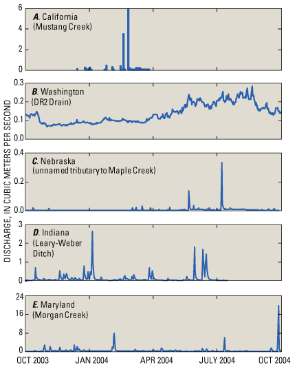
Figure 4. Hydrographs for the surface-water outflows of the five focus watersheds show large differences in the magnitudes and annual distribution of streamflow in these watersheds. [Note scale for stream discharge is different for each graph.] 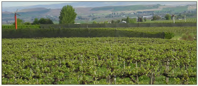
A vineyard grows on an irrigated hillside in the Granger basin, Washington.
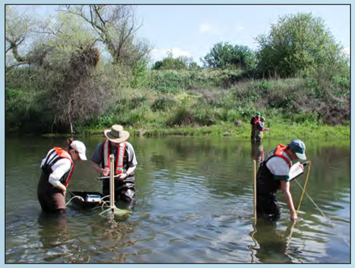
USGS scientists collect hydrologic data in the Lower Merced River basin, California. 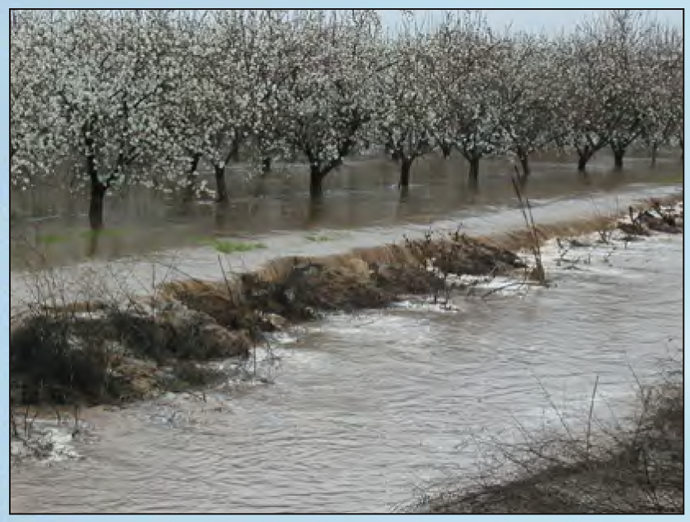
Excess water produces overland flow in an almond orchard in the Lower Merced River basin, California. 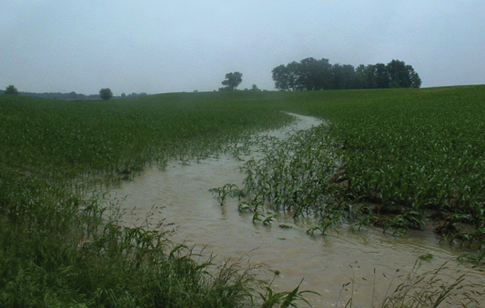
Surface runoff flows from a corn field in the Sugar Creek basin, Indiana. 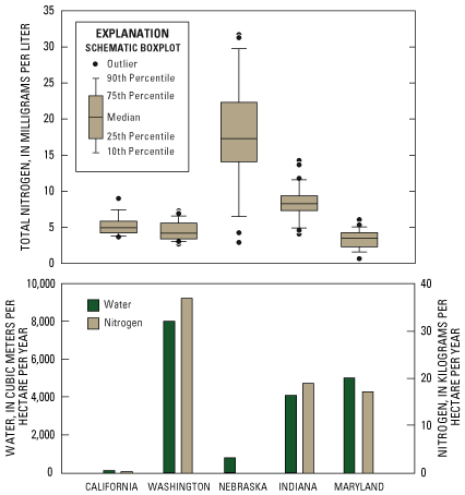
Figure 5. Concentrations of total nitrogen measured at the focus watershed outflows during 2004 show differences in both the magnitudes of peak concentrations and the range of concentrations. Annual yields of water (annual watershed outflow/watershed area) and nitrogen (annual load exported in the stream/watershed area) from the focus watersheds were closely correlated and show that stream exports of nitrogen are greatest where surface-water outflows are greatest. [Insufficient data to calculate nitrogen yield for the Nebraska watershed.] Nitrogen Concentrations in Streams and Nitrogen Exports From Catchments Reflect Differences in HydrologyComparison of the concentrations of total nitrogen measured in the streams of the focus watersheds illustrates the influence of hydrologic conditions on the transport of nitrogen from fields (fig. 5). In addition to the concentrations in these streams, the total load of nitrogen exported from each watershed (fig. 5) has important consequences for downstream receiving waters (see sidebar, Excess Fertilizer in the Environment). The load of nitrogen exported in surface water is the product of the volume of streamflow leaving the watershed and the nitrogen concentration in that water. Both nitrogen concentrations and streamflow, as well as how each varies with time, determine the total annual load of nitrogen exported from each catchment.
Implications For ManagementEffective management of agricultural chemicals requires the application of chemicals at the appropriate time and at the appropriate rate, and knowledge of how these chemicals are most likely to be transformed and(or) transported in the range of environmental settings that comprise the Nation’s agricultural lands. Knowledge about the predominant water flow paths (figs. 2 and 3) and understanding their characteristic transport time scales can guide selection of the most effective management practices for particular environmental settings (see sidebar, How Agricultural Fields are Linked to Groundwater and Streams). For example, buffer zones around streams can be effective where overland flow is important, but would be of little value where most water in a watershed travels to the stream through subsurface drains or by deep groundwater flow paths. Knowledge about which water flow paths predominate in particular settings also helps managers develop appropriate monitoring plans. In situations where most water in a watershed is transported along deep groundwater flow paths, responses to management changes may not be apparent in stream-water quality for several years. In contrast, responses in stream chemistry may be apparent almost immediately in areas with short flow paths, such as watersheds with extensive overland flow and/or tile-drain systems. Ongoing WorkThe USGS is currently studying two additional agricultural watersheds using the same whole-watershed approach (fig. 1). Results from the South Fork Iowa River watershed will add to our understanding of the movement and fate of herbicides and nutrients in Midwestern watersheds dominated by corn and soybean row cropping with extensive surface and subsurface drainage networks. The Bogue Phalia watershed in northwestern Mississippi is dominated by cotton, rice, and soybean row cropping, and the results of work there will increase our knowledge of the movement and fate of pesticides in humid, subtropical agricultural settings. References CitedBayless, E.R., Capel, P.D., Barbash, J.E., Webb, R.M.T., Hancock, T.L.C., and Lampe, D.C., 2008, Simulated fate and transport of metolachlor in the unsaturated zone, Maryland, USA: Journal of Environmental Quality, v. 37, p. 1064–1072. Capel, P.D., Hamilton, P.A., and Erwin, M.L., 2004, Studies by the U.S. Geological Survey on sources, transport, and fate of agricultural chemicals: U.S. Geological Survey Fact Sheet 2004–3098, 4 p., available at https://pubs.usgs.gov/fs/2004/3098/. Capel, P.D., McCarthy, K.A., and Barbash, J.E., 2008, National, holistic, watershed-scale approach to understand the sources, transport, and fate of agricultural chemicals: Journal of Environmental Quality, v. 37, p. 983–993. Dodds, W.K., Bouska, W.W., Eitzmann, J.L., Pilger, T.J., Pitts, K.L., Riley, A.J., Schloesser, J.T., and Thornbrugh, D.J., 2009, Eutrophication of U.S. freshwaters—Analysis of potential economic damages: Environmental Science and Technology, v. 43, no. 1, p. 12–19. Domagalski, J.L., Ator, S., Coupe, R., McCarthy, K., Lampe, D., Sandstrom, M., and Baker, N., 2008, Comparative study of transport processes of nitrogen, phosphorus, and herbicides to streams in five agricultural basins, USA: Journal of Environmental Quality, v. 37, p. 1158–1169. Essaid, H.I., Zamora, C.M., McCarthy, K.A., Vogel, J.R., and Wilson, J.T., 2008, Using heat to characterize streambed water flux variability in four stream reaches: Journal of Environmental Quality, v. 37, p. 1010–1023. Fisher, L.H., and Healy, R.W., 2008, Water movement within the unsaturated zone in four agricultural areas of the United States: Journal of Environmental Quality, v. 37, p. 1051–1063. Green, C.T., Fisher, L.H., and Bekins, B.A., 2008a, Nitrogen fluxes through unsaturated zones in five agricultural settings across the United States: Journal of Environmental Quality, v. 37, p. 1073–1085. Green, C.T., Puckett, L.J., Böhlke, J.K., Bekins, B.A., Phillips, S.P., Kauffman, L.J., Denver, J.M., and Johnson, H.M. 2008b, Limited occurrence of denitrification in four shallow aquifers in agricultural areas of the United States: Journal of Environmental Quality, v. 37, p. 994–1009. Hancock, T.C., Sandstrom, M.W., Vogel, J.R., Webb, R.M.T., Bayless, E.R. and Barbash, J.E., 2008, Pesticide fate and transport throughout unsaturated zones in five agricultural settings, USA: Journal of Environmental Quality, v. 37, p. 1086–1100. Puckett, L.J., Zamora, C., Essaid, H., Wilson, J.T., Johnson, H.M., Brayton, M.J., and Vogel, J.R., 2008, Transport and fate of nitrate at the ground-water/surface-water interface: Journal of Environmental Quality, v. 37, p. 1034–1050. Steele, G.V., Johnson, H.M., Sandstrom, M.W., Capel, P.D., and Barbash, J.E., 2008, Occurrence and fate of pesticides in four contrasting agricultural settings in the United States: Journal of Environmental Quality, v. 37, p. 1116–1132. U.S. Environmental Protection Agency, 2008, Mississippi River Gulf of Mexico Watershed Nutrient Task Force: U.S. Environmental Protection Agency Office of Wetlands, Oceans, and Watersheds website, accessed March 24, 2009, at http:// www.epa.gov/msbasin/. Vogel, J.R., Majewski, M.S., and Capel, P.D., 2008, Pesticides in rain in four agricultural watersheds in the United States: Journal of Environmental Quality, v. 37, p. 1101–1115. Webb, R.M.T., Wieczorek, M.E., Nolan, B.T., Hancock, T.C., Sandstrom, M.W., Barbash, J.E., Bayless, E.R., Healy, R.W., and Linard, J., 2008, Variations in pesticide leaching related to land use, pesticide properties, and unsaturated zone thickness: Journal of Environmental Quality, v. 37, p. 1145–1157. |
USGS promotes public access to water-quality information. This fact sheet and other publications from the National Water-Quality Assessment Program are available on the World Wide Web at http://water.usgs.gov/nawqa/bib/. Contacts for additional information: Kathleen McCarthy, U.S. Geological Survey(503) 251-3257, mccarthy@usgs.gov Paul Capel, U.S. Geological Survey Part or all of this report is presented in Portable Document Format (PDF); the latest version of Adobe Reader or similar software is required to view it. Download the latest version of Adobe Reader, free of charge. |

![]() U.S. Department of the Interior |
U.S. Geological Survey
U.S. Department of the Interior |
U.S. Geological Survey
URL: http://
pubsdata.usgs.gov
/pubs/fs/2009/3042/index.html
Page Contact Information: GS Pubs Web Contact
Page Last Modified: Tuesday, 29-Nov-2016 17:33:15 EST
