|
|
For more than 100 years the U.S. Geological Survey (USGS) has provided
earth-science information to help others understand and manage the Nation's
energy, land, mineral, biological, and water resources. Such information
is used in many decisions regarding management and optimum use of
Mississippi's natural resources and to address major environmental,
economic, and health issues, such as contamination of the environment by
hazardous wastes, adequacy of suitable-quality water supplies, nutrient
input to streams and estuaries, distribution of coal and mineral resources,
and effects of urban development and agriculture on the environment.
|

|
|
|
|
The U.S. Geological Survey works closely with the Mississippi Department of
Transportation (MDOT). USGS streamflow records, hydrologic analyses of
basins, and hydraulic analyses of flooding potential at proposed highway
bridges provide information used by the MDOT to design those bridges.
Flood-frequency and hydraulic characteristics at highway bridges are
determined from historic flood elevations recovered by the USGS,
cross-section data, and correlations with nearby gaging stations.
Streamflow data are collected to define the hydraulic characteristics of
other ungaged sites as requested by the MDOT. This information provides the
basis for the design of highways and drainage structures, and it is used by
local agencies and the general public to guide floodplain management.
During 1993-96, the USGS completed 264 bridge-site studies; in 1996, 104
such studies were completed. Many of the analyses were for multiple bridge
openings. Also, statistical analyses of streamflow data were provided as
requested by the MDOT.
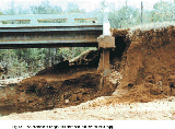
Streambanks and channel scour near bridge piers and abutments (fig. 1)
during floods has resulted in more bridge failures than all other causes in
recent history. The design and maintenance of bridge foundations require
consideration of the maximum depth of scour that could occur during an
extreme flood. |
In 1993, the USGS, in cooperation with the MDOT, began a 5-year study to
evaluate observed and potential scour conditions at selected bridges.
Since 1993, the USGS has completed 102 scour-evaluation studies.
(Larger Version, 388K GIF)
|
|
Figure 1. An example of bridge-abutment scour in central
Mississippi.
| |
|
|
|
|
|
The USGS has collected surface-water data in Mississippi since 1899. These
data are stored in computerized local and national data bases and
disseminated to cooperators, educational institutions, private
organizations, and the public in published reports, and by the Internet.
In addition, the USGS responds to thousands of data requests from the
general public each year.
The current surface-water data-collection program in Mississippi provides
continuous stage and discharge information for 88 sites, continuous stage
information for an additional 7 sites, and periodic stage and discharge
information for 59 other sites.
As of January 1997, 83 of 96 continuously recording streamflow gaging
stations were equipped with satellite transmitters. In 1995 the USGS
became one of the first organizations to apply this technology to the
Internet by developing a real-time Surface Water Data page that provides
tabular and graphic forms of continuously updated stage and discharge data,
in addition to long-term flow statistics and a gage description. To view
or retrieve these data on the Internet, go to:
http://water.usgs.gov/swr/MS/ |
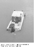
With significant advancement of acoustic-signal processing, it is possible
to profile three-dimensional velocity vectors with a high degree of
precision and repeatability. Recently the USGS began using an acoustic
Doppler current profiler to measure discharge at sites on some of the
larger rivers in Mississippi. This method is used to model
three-dimensional velocity near bridges, dams, and other flow-control
structures to document effects of tidal flow and backwater conditions on
rivers (fig. 2).
(Larger Version, 291K GIF)
|
|
Figure 2. Using an acoustic Doppler current meter to
collect three-dimensional velocity data.
|
|
|
|
|
|
|
Ground water supplies 80 percent of all the freshwater used in Mississippi.
Increasing population and the accompanying economic growth are expected to
increase the demand for freshwater. The USGS, in cooperation with State
and local agencies, investigates ground-water resources in Mississippi.
In northeastern Mississippi, most ground water is supplied by the
Eutaw-McShan aquifer and the Tuscaloosa aquifer system. A digital model
developed by the USGS is being used to simulate flow in the aquifer system
to understand the resource and its capacity. The model is being expanded
to include the Coffee Sand and Paleozoic aquifers.
|
In coastal Jackson County, the location and depth of water-bearing sands
were compiled and mapped by interpreting more than 1,600 well lithology
records. Information determined from each record was entered into a
geographic information system (GIS) data base. |
|
|
|
In 1984, Congress directed the U.S. Army Corps of Engineers and the Soil
Conservation Service, now the Natural Resource Conservation Service, to
establish demonstration watersheds for studying erosion and sedimentation
in agricultural watersheds. The Demonstration Erosion Control project is
in the upper Yazoo River Basin in north-central Mississippi. The project
is an ongoing, multiagency effort for planning, constructing, and
evaluating projects to alleviate erosion, sedimentation, and flooding
problems in the bluff hills that border the Mississippi River alluvial
plain, known locally as the "Delta". Analyses of the data by the USGS have
identified trends in stream discharge, suspended-sediment concentration,
and sediment discharge data for several of the sites. |
|
|
|
|
|
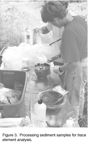
The goals of the National Water-Quality Assessment (NAWQA) Program are to
describe trends in the quality of a large part of the Nation's water
resources and to identify the major natural and human factors that affect
the quality of these resources. Assessment of the Mississippi Embaymant
study unit, which covers an area of about 49,800 square miles, and includes
parts of Arkansas, Kentucky, Louisiana, Mississippi, Missouri, and
Tennessee, began in 1994. Much of the NAWQA work is done at more than 160
sites selected to represent a broad spectrum of land-use conditions.
The occurrence and distribution of common inorganic constituents, trace
elements, nutrients, and pesticides and other organic compounds in surface
and ground water are bring investigated. The amounts of nutrients and
suspended sediment being transported by streams are being determined (fig.
3). Ecological characteristics of the area including assessment of algal,
fish, and aquatic macroinvertibrate communities are being evaluated as
integrated indicators of water quality. Organochlorine compounds, PCB's
(polyclorinated biphenyls), and trace elements are measured in fish tissue
and in bed sediments. |

(Larger Version, 291K GIF)
|
|
Figure 3. Processing sediment samples for trace element
analysis.
| |
|
|
|
|
|
The USGS recently began a project with the U.S. Environmental Protection
Agency that will use GIS to assist Federal, State, and local agencies to
prioritize their wetlands restoration efforts. The project will use
information such as soil type, amount of time areas are flooded, vegetative
cover, and digital terrain models to assess the likelihood that an area
could be restored to a functional wetland.
Other wetland studies are being conducted in Mississippi by the USGS
National Wetlands Research Center in Lafayette Louisiana. Bottomland
hardwood reforestation research at Yazoo National Wildlife Refuge is
designed to assist managers in improving restoration success in farmed
wetlands of the Delta Region. The effects of fire on the restoration of
the longleaf pine savanna that the sandhill cranes require for habitat are
being studied at the Mississippi Sandhill Crane National Wildlife Refuge.
|
The USGS Mississippi Cooperative Fish and Wildlife Research Unit is located
at Mississippi State University in Stakrville. Research encompasses
sport-fish-population dynamics, ecology and management of lower Mississippi
river fishes, and the conservation biology of sensitive species in
Mississippi and the Caribbean. Other studies include collaboration with
State agencies and the Delta Wildlife Foundation on survival of largemouth
bass and in providing the Catfish Farmers of America information to reduce
losses of fish to fish-eating birds. The USGS Patuxent Wildlife Research
Center field station at Vicksburg is studying the response of waterfowl and
migrant birds to land-use management strategies. |
|
|
|
|
|
Among the most popular and versatile products of the USGS are
1:24,000-scale topographic maps (1 inch on the map represents 2,000 feet on
the ground). Some of the map data are available in digital formats. These
maps depict basic natural and cultural features of the landscape, such as
lakes and streams, highways and railroads, boundaries, and geographic
names. Contour lines are used to depict the elevation and shape of
terrain. Mississippi is covered by 850 maps at this scale, which is useful
for civil engineering, land-use planning, natural-resource monitoring, and
other technical applications. These maps have long been favorites with the
general public for outdoor uses, including hiking, camping, exploring, and
back-country fishing expeditions. |
The USGS National Mapping Program has developed a new agreement with
Mississippi Automated Resources Information Systems (MARIS) for producing
Digital Tagged Vector Contour Data (TVC). The USGS is supplying MARIS with
elevation contours in exchange for the completed level-2 tagged vector
contour data. TVC's are an intermediate product used for developing
Digital Elevation Models (DEM's) as well as Digital Line Graph Hypsography. |
|
|
|
The USGS operates Geologic Information Centers; many of the topics they
focus on are of interest to people in Mississippi. The National Earthquake
Information Center (NEIC) in Golden, Colorado, is deploying the U.S.
National Seismograph Network (USNSN), which, when completed, will consist
of about 60 seismograph stations nationwide. The USNSN monitors nationwide
seismicity, provides early notification of seismic events to national-level
emergency-services personnel, maintains an archive of high-quality digital
data on national seismicity, and provides public information. A USNSN
station in Oxford, Mississippi, sends data by satellite telemetry to the
NEIC. |
|
|
|
Much of southern Mississippi lies in the Gulf Coast region. This region
has a long history of producing large amounts of petroleum and is
experiencing a resurgence of interest in exploring for petroleum trapped
around and underneath large subsurface salt structures. The USGS recently
began a study of these structures to understand how they were formed and to
evaluate their potential for containing trapped petroleum. |
|
|
|
|
|
Coal accounts for about one-fourth of the total energy and more than
one-half of the electricity generated in the United States. Even with
substantial increases in energy conservation and in natural gas use to meet
increased demands for energy, coal will continue to be a major contributor.
New technologies to use coal will require resources that fit explicit
quality requirements. Therefore, information about the location, quantity,
and quality of the Nation's coal resources to be consumed during the next
20 years, classified particularly by best end use, will be needed by
national and regional planners. In the National Coal Assessment, the USGS
will work with the Mississippi Office of Geology to identify the location
and quality of coal resources, including coal that may be suitable for
export, on public and private lands. The USGS is working with several
Federal and State agencies to aid Mississippi and its industry to develop
cost-effective strategies to mitigate acid-rain and acidic mine drainage
problems that are associated with coal burning and mining and to remedy
present contamination. |
The USGS STATEMAP program is supporting detailed mapping in east-central
Mississippi where economically significant deposits of lignite are being
considered for power generation. Lignite production will require strip
mining and construction of a power plant. This part of the State also is a
recharge area for an important aquifer where protection of the ground-water
supply is necessary. The project also is studying the distribution and
extent of potentially economic ceramic clay. |
|
|
|
The Mississippi Delta Management Systems Evaluation Area project is an
interagency 5-year study to assess how agricultural activities affect the
water resources in the Delta and to increase the knowledge needed to design
and evaluate management practices as components of farming systems. The
study is being conducted at sites within three Delta oxbow-lake watersheds,
where cotton production is the primary land use. |
|
|
|
|
|
The USGS, in cooperation with the Surface Geology Division of the
Mississippi Office of Geology, is working through the statemap program to
map the subsurface geology in north-central Mississippi. Shallow aquifers
in these units could be affected by proposed development of a lignite
strip-mine and an electric power generating plant. The geology of 16
quadrangles, including parts of Choctaw, Oktibbeha, Winston, Montgomery,
Attala, Webster, Calhoun, and Grenada Counties, will be mapped. In this
area, several towns depend on ground water for their water supply. |
The Surface Geology Division also has received USGS National Coal Resources
Data System (NCRDS) grants for 1996 and 1997. Lignite seams found in
recent core holes and in about 90 drilling records have been added to the
NCRDS data base. |
|
|
|
|
|
The USGS and the National Park Service (NPS) have established an
interagency agreement to produce digital raster graphics (DRG) for barrier
islands along the Mississippi Gulf Coast. The DRG's are scanned from USGS
topographic maps, and can be used as an accurate base for a GIS. A private
company is producing the DRG's for the USGS and participating agencies
under a Federal-private partnership. DRG's will be prepared for all
1:24,000-, 1:100,000-, and 1:250,000-scale topographic maps covering the
NPS area of interest. The USGS and the NPS also are cooperating to produce
digital line graph, DEM's, and digital orthophotoquad data for the Gulf
Islands National Lakeshore.
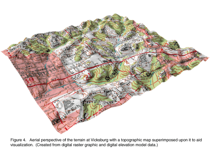
The USGS has joined the U.S. Army Corps of Engineers, Vicksburg, and the
U.S. Department of Agriculture Natural Resources Conservation Service to
fund completion of the 206 remaining 1:24,000-scale DEM's for Mississippi.
The models can be used for topographic visualization (fig. 4). When
complete, Mississippi will have an accurate, Statewide digital topographic
data base suitable for GIS analysis. |
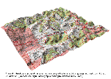
(Larger Version, 291K GIF)
|
|
Figure 4. Aerial perspective of the terrain at Vicksburg
with a topographic map superimposed upon it to aid visualization. (Created
from digital raster graphic and digital elevation model data.)
| |
|
|
|
The work of the USGS in Mississippi is accomplished in part through
cooperation with local, State, and other Federal agencies who share in the
planning and financial support of the program. Agencies that provided
funding and services in support of the USGS activities during 1995-97
include: the City of Jackson; the Harrison County Board of Supervisors; the
Harrison County Development Commission; the Jackson County Board of
Supervisors; the Jackson Port Authority; the Gulf States Marine Fisheries
Commission; the Mississippi Automated Resource Information System; the
Mississippi Department of Agriculture and Commerce; the Mississippi
Department of Environmental Quality, the Office of Land and Water
Resources, the Office of Geology, and the Office of Pollution Control; the
Mississippi Department of Health; Mississippi State University; the
Mississippi Department of Transportation; the Mississippi Soil and Water
Conservation Commission; the Pat Harrison Waterway District; the Pearl
River Basin Development District; the Pearl River Valley Water Supply
District; the Yazoo Mississippi Delta Joint Water Management District; the
National Park Service; the U.S. Army Corps of Engineers, Mobile and
Vicksburg Districts; the U.S. Environmental Protection Agency; the U.S.
Department of Agriculture, Natural Resources Conservation Service, and the
Agricultural Research Service; the Mississippi Water Resources Research
Institute; and the Mississippi Rural Water Association.
|