
|
|
|
|
|
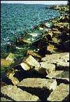
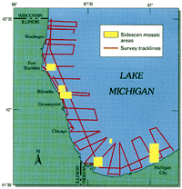
Erosion and flooding of Lake Michigan's coastline have resulted in extensive damage to domestic, recreational, and industrial facilities.As the result of fluctuating water levels in the Great Lakes, hundreds of millions of dollars have been lost by the 40 million people and by the many industries vital to our economy that are located in the Great Lakes Basin. During each episode of high lake levels, rates of bluff erosion increase, beachfront property is lost, and structures and beaches are submerged. During each intervening episode of low lake levels, navigation channels and harbors require extensive dredging of sediments that commonly are polluted. Also, hydroelectric output decreases, the load on freshwater pumping facilities increases, and sewage disposal becomes a more complex issue. U.S. Geological Survey (USGS) scientists initiated a coastal study of Southern Lake Michigan in response to disastrous flooding in Chicago.Since the turn of the century, water levels of Lake Michigan have increased in a series of peaks, each higher than the last. The culmination of the high-water levels in 1985-87 caused extensive damage. The USGS initiated a 5-year study to document the timing and magnitude of prehistoric lake-level fluctuations, and to assess some of the important geologic processes responsible for severe erosion of the Illinois-Indiana shoreline. The study is a cooperative effort involving research staff from the Illinois State Geological Survey, the Indiana Geological Survey, Indiana University, Purdue University, Northeast Illinois University, the University of Illinois at Chicago, Oregon State University, the University of Washington, the University of Rhode Island, and the Woods Hole Oceanographic Institution. USGS investigations involved basic geophysical data collection and ground-truth mapping.
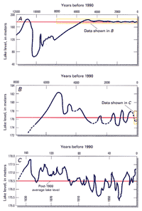
Extensive single-channel seismic surveys and piston-core recoveries were used to map lake deposits. Detailed sediment studies of exposed beach ridges and modern high-water deposits around the lake margin complement the seismic surveys in documenting the age, frequency, and magnitude of high-water levels. Measurements of bluff recession, studies of evolution of beaches, and effects of manmade structures on erosion and sand transport contributed to a more complete understanding of the processes at work. The role of wind in removing sand from the nearshore system to form such massive dunes, such as those in the Indiana Dunes National Lakeshore, and the impact of ice as an agent to erode as well as to protect the coast, were analyzed in developing a model. The model shows the sources, pathways, and sinks for nearshore sediments that are essential to predict the future of the coastline. USGS studies of lake level show that prehistoric levels exceed modern-day fluctuations.Prehistoric variations in lake levels have exceeded by as much as a factor of 2 (that is, more than 3 meters) the 1.6-meter fluctuation that spanned the 1964 low level and the 1985-87 high level. One such high level occurred in the 17th century before the Great Lakes area was widely settled by Europeans. Greater lake-level fluctuations related to future climate change are not only possible, but are probable. However, the impact of possible future global warming on the magnitude and frequency of water-level cycles remains uncertain. Ice ridges along the lakeshore, sometimes as high as 7 meters, do not protect the shoreline from winter erosion, as previously thought.
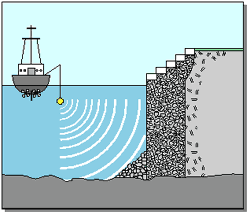
The repeated formation and breakup of nearshore ice ridges each winter along much of the shoreline results in significant transport and removal of beach sand entrapped in floating fragments of ice. Sediment transport in ice occurs along shore as well as offshore into the deep lake. This episodic process is one of the principal mechanisms by which sand is lost from the nearshore system. USGS investigators monitor geological processes to determine the mechanisms for and extent of sediment movement.Bluff retreat between Wilmette and Waukegan, Illinois, varies from 10 to 75 centimeters per year, and averages 20 to 25 centimeters per year. Erosion rates north of Waukegan, however, approach 300 centimeters per year. Sediment eroding from bluffs provides most of the sand to the nearshore zone. As more structures are erected to protect the bluffs, less sand is available to the system. Consequently, the nearshore sand reservoir has shown a dramatic decrease in volume over the past 20 years. As this sand supply dwindles, the finer-textured lakebed sediments are exposed to wave attack, inevitably accelerating coastal retreat. Sidescan sonar shows conclusively how, where, and why revetments designed to protect Chicago's lakeshore are failing; remedial designs based on these studies are being implemented.
|
Related Publications: Popular Beach Disappears Underwater in Huge Coastal Landslide - Sleeping Bear Dunes, Michigan
- USGS Fact Sheet 020-98 The Southern Lake Michigan Coastal Erosion Study CD-ROM - USGS Open File Report 94-255 Related Links: Great Lakes Science Center Illinois State Geological Survey Indiana Geological Survey Indiana University Purdue University Northeast Illinois University University of Illinois at Chicago Oregon State University University of Washington University of Rhode Island Woods Hole Oceanographic Institution |