|
|
|
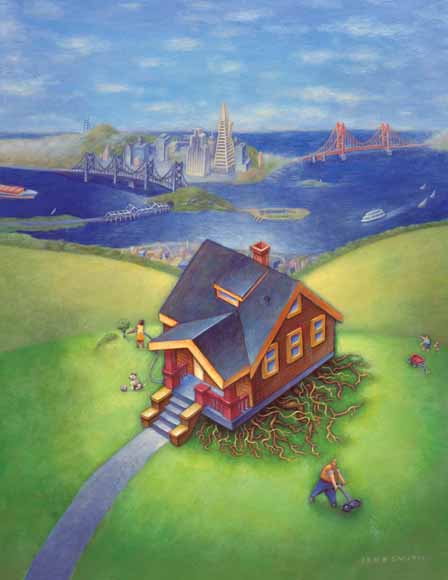
The Bay Area Is “Earthquake Country” This handbook provides information about the threat posed by earthquakes in the San Francisco Bay region and explains how you can prepare for, survive, and recover from these inevitable events. If you live or work in the region, you need to know why you should be concerned with earthquakes, what you can expect during and after a quake, and what you need to do beforehand to be safe and reduce damage. |
Download this handbook as a 32-page PDF file (gip-15.pdf; 5.8 MB).
There are many faults in the Bay Area certain to produce large earthquakes in the future. All Bay Area communities are at risk from the damaging effects of quakes—strong shaking, landsliding, and liquefaction. Scientists estimate that there is more than a 60% chance of a damaging earthquake striking the region in the next 30 years.
The disastrous 1989 magnitude 6.9 Loma Prieta earthquake was not the “Big One”! If you do not prepare for the next big quake in the Bay Area, you and your family could be left without a home, food and water, medical supplies, and financial resources. START PREPARING NOW!
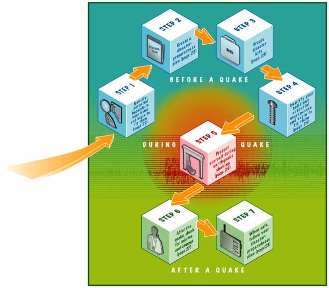
STEP 1. Identify potential hazards in your home and begin to fix them.
STEP 2. Create a disaster-preparedness plan.
STEP 3. Create disaster kits.
STEP 4. Identify your building’s potential weaknesses and begin to fix them.
STEP 5. Protect yourself during earthquake shaking.
STEP 6. After the quake, check for injuries and damage.
STEP 7. When safe, continue to follow your disaster-preparedness plan.
Earthquake information on the Web
In the Great San Francisco earthquake of 1906, thousands of people died, and many homes were destroyed. The hazard remains in the Bay Area, and the homes of today’s families are at risk! (USGS image)
We know that the San Andreas Fault produces large earthquakes and that many other Bay Area faults are also hazardous. However, even knowing this, it can be difficult to understand how to use this information to make us safer in our daily lives. Should we care only if we live near the San Andreas Fault, or is every place in the Bay Area just as dangerous?
This eight-page section describes where earthquakes occur in northern California. It also explains how earthquakes will shake the ground and cause damage in other ways, such as liquefaction and landslides (see pages 8 through 11). Technical terms used throughout this book are explained in the Glossary (see page 31).
|
Don’t be fooled!— Myth number 1 “BEACHFRONT PROPERTY”?
The idea or myth of California sliding into the Pacific Ocean in an earthquake and creating new beachfront property to the east appeals to those having a bit of fun at the Golden State’s expense. Although part of the State west of the San Andreas Fault system is very slowly moving northward and in millions of years could become an island, earthquakes caused by this horizontal motion of the Earth’s tectonic plates will not make California disappear into the sea, like fabled Atlantis. |
Plate Motions Load the Faults

Deep beneath California, the Pacific and North American Plates relentlessly grind past one another, straining or “loading” faults in the Earth’s rigid crust above. The horizontal (“strike slip”) movement between these plates along the San Andreas Fault Zone is about 1.7 inches per year (40 mm/yr), about as fast as your fingernails grow. At this rate, Los Angeles will be west of San Francisco in about 12 million years.
JANUARY 1700 M 9
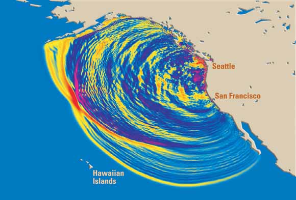
In this computer simulation, tsunami waves are radiating outward after a magnitude (M) 9 earthquake that occurred on the Cascadia Subduction Zone offshore of northern California, Oregon, and Washington on January 26, 1700. This view shows the waves 4 hours after the quake. Colors indicate wave heights—red is highest. Along parts of the coast of the Pacific Northwest, 30-foot-high (9 m) waves rushed inland. Within 20 hours the tsunami did damage throughout the Pacific, and it is well documented in written records from Japan. (For more information go to https://pubs.usgs.gov/circ/c1187/. ”Orphan tsunami” Web address: https://pubs.usgs.gov/pp/pp1707/.)
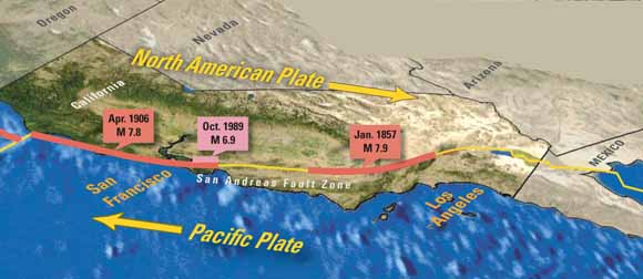
JANUARY 1857 M 7.9
The magnitude (M) 7.9 Fort Tejon earthquake in 1857 caused a horizontal shift of about 30 feet (9 m) on this stretch of the southern San Andreas Fault (red arrows indicate this “strike-slip” movement). Although the quake ruptured nearly 200 miles (300 km) of the fault, it did little damage because southern California’s population was small at that time. (USGS photo)
APRIL 1906 M 7.8
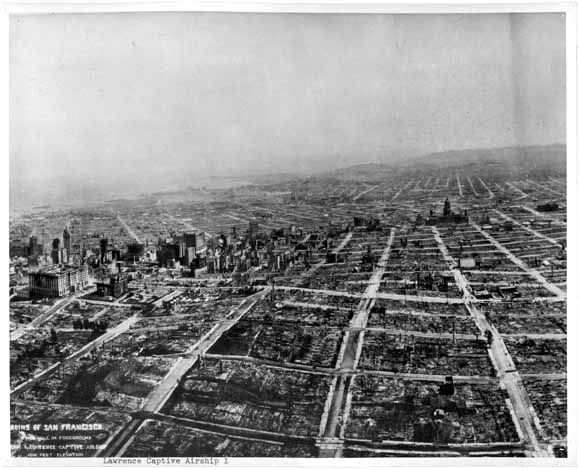
In the Great 1906 magnitude (M) 7.8 earthquake, nearly 300 miles (480 km) of the San Andreas Fault ruptured, producing strong shaking along all of coastal northern California. Shaking was most intense in Santa Rosa and San Francisco. In San Francisco, broken water mains kept firefighters from battling the fires that swept through the city and contributed to the devastation shown in this photograph (looking south) taken by George Lawrence by his “Captive Airship,” or kite train 5 weeks after the earthquake.
For more information go to:
http://neic.usgs.gov/neis/plate_tectonics/rift_man.html
https://pubs.usgs.gov/gip/earthq3/
In the last half of the 1800s, damaging earthquakes (magnitude 6 or greater) occurred in the San Francisco Bay region on average every 4 years. However, this changed in 1906:
Fault Rupture Lengths for Historical Quakes in the Bay Area
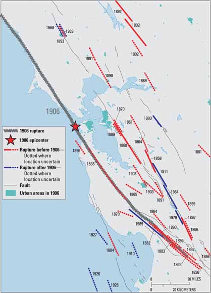
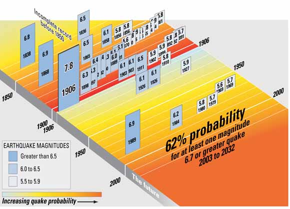
The Past and Future of Significant Bay Area Quakes
Quakes can cause damage far from the fault rupture...
|
|
| 1969—Damage in Santa Rosa |
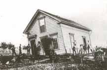
1906—Damage in Healdsburg |
|
|
| 1868—Damage in Hayward |
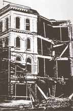
1865—Damage in San Francisco |
(Historical photos of shaking damage courtesy National Information Service for Earthquake Engineering (NISEE), University of California, Berkeley.)
The threat of future quakes extends across the Bay Area...
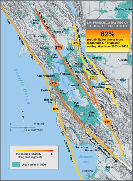
There is a 62% probability that at least one earthquake of magnitude 6.7 or greater will occur on a known or unknown San Francisco Bay region fault before 2032. After a century of study by geologists, many faults have been mapped in the region, but not all faults are apparent at the surface—some quakes occur on previously unknown faults.
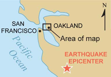
An example of a damaging quake on a previously unknown fault is the September 3, 2000, Yountville (Napa) earthquake. This magnitude 5.2 quake struck at 1:36 a.m., 10 miles northwest of Napa, rudely awakening many residents of the Bay Area. It injured 25 people, caused at least $10 million in damage, and forced 70 people to seek shelter at Red Cross facilities.
Damage in earthquakes is mainly from shaking. The intensity of shaking that a structure will experience during an earthquake is a function of three main factors:
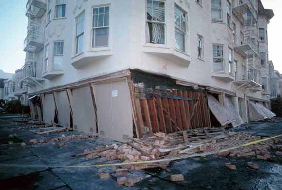
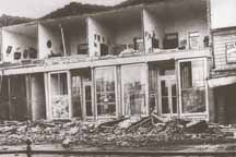
Buildings in the Marina District of San Francisco were badly damaged in the 1989 Loma Prieta earthquake. “Soft story” buildings, typically with parking on ground floor, like the one pictured here, are common throughout the Bay Area and are particularly at risk when exposed to strong shaking. (USGS photo)
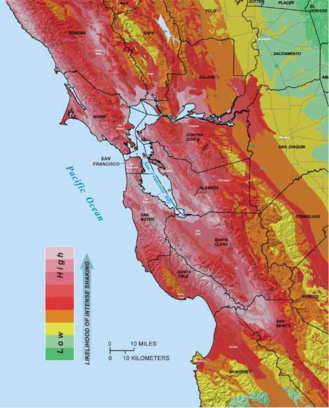
Expected Levels of Shaking from Future Earthquakes
For more information:
http://www.consrv.ca.gov/cgs/rghm/psha/index.htm
Soft Soils Amplify Earthquake Shaking

|
|
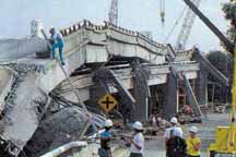
The Cypress freeway structure in Oakland was built in the 1950s, before the use of modern seismic-safety standards. Part of the structure standing on soft mud (dashed red line) collapsed in the 1989 magnitude 6.9 Loma Prieta earthquake, whose epicenter was nearly 60 miles (100 km) to the south. Adjacent parts of the structure (solid red) that were built on firmer ground remained standing. Seismograms (upper right) show that the shaking was especially severe in the soft mud. (Photo by Lloyd S. Cluff, Pacific Gas & Electric)
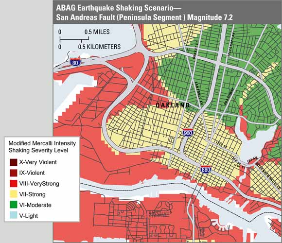
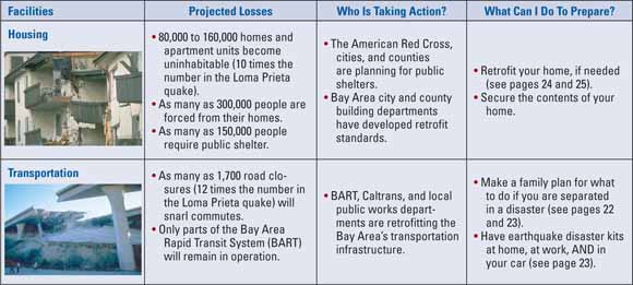
The Exposure of the Bay Area’s Built Environment to Violent Earthquake Shaking—Many critical facilities in the Bay Area will likely experience damaging earthquake shaking in the next 30 years.
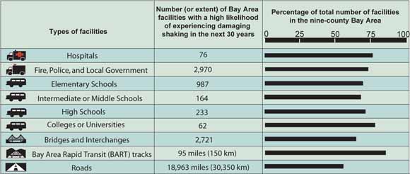
Source: Association of Bay Area Governments, 2005 (http://quake.abag.ca.gov/mitigation/pickcrit.html).
Although most earthquake damage is caused by shaking, other damaging effects of quakes can be just as devastating. For example, in the Great 1906 earthquake, the shaking damage in San Francisco was followed by fires that raged through the city almost uncontrolled, in part because water mains had broken in the quake. These and other destructive effects of quakes are discussed below.

| 
|
Fires—Earthquakes in urban areas are often followed by destructive fires because (1) gas lines break, (2) electrical shorts ignite fires, (3) damaged water tanks and broken pipes limit water for firefighting, and (4) clogged roads and collapsed bridges prevent firefighter access. These factors can lead to fires spreading, causing extensive additional damage and burning entire neighborhoods. This photo shows fires in San Francisco’s Marina District following the 1989 magnitude 6.9 Loma Prieta earthquake (photo courtesy of CBS 5). |
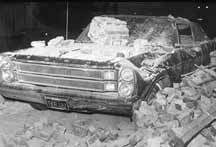
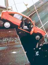
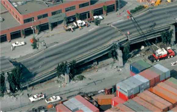
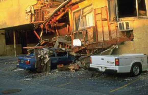
Damaged bridges, pipelines, powerlines, and roads—Earthquakes often damage roads, hindering rescue and recovery efforts and causing accidents. Water and sewer pipeline breaks result in water loss and can cause “sinkholes” that undermine roads and buildings. Damage to natural gas and electrical distribution systems can cause fires, as well as major service outages. This car crashed when a section of the eastern span of the San Francisco-Oakland Bay Bridge collapsed in the 1989 magnitude 6.9 Loma Prieta earthquake (Earthquake Engineering Research Institute photo).
|
| 
|
Dam failures—Earthquake shaking can cause dams to fail, potentially causing catastrophic downstream flooding and reduced water supplies. In addition, many dams provide hydroelectric power, which could be critically needed following a quake. Cracks in the top of this dam were caused by the 1989 magnitude 6.9 Loma Prieta earthquake (USGS photo).
|
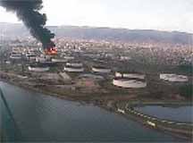
Hazardous material releases—Earthquake damage can cause releases of hazardous materials from refineries and other chemical storage and distribution systems, research and industrial laboratories, manufacturing plants, and railroad tank cars. Oil was released and caught fire when this storage facility was damaged by the 1999 magnitude 7.4 Izmit, Turkey, earthquake (photo by Kandilli Observatory and Earthquake Institute).
|
|
Don’t be fooled!— Myth number 2 “AND THE EARTH OPENED...”
A popular literary device is a fault that opens during an earthquake and then closes to swallow up an inconvenient character. Unfortunately for principled writers, such “carnivorous” faults exist only in novels and B-movies. |
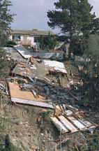
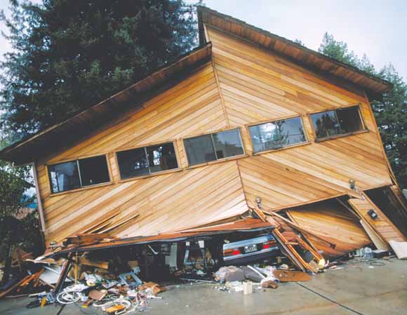
Landslides—Earthquakes can trigger landslides that damage roads, buildings, pipelines, and other infrastructure. Steeply sloping areas underlain by loose or soft rock are most susceptible to earthquake-induced landslides. This home was destroyed when the hillside beneath it gave way following the 1994 magnitude 6.7 Northridge earthquake (FEMA photo).
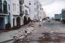
Liquefaction—Earthquake shaking can cause soils to behave like a liquid and lose their ability to support structures. Liquefaction often causes buried gas and water lines to break. The highest hazard is in low-lying areas where there are loose, sandy soils or poorly compacted artificial fill. This photo shows liquefaction-related damage in the Marina District of San Francisco following the 1989 magnitude 6.9 Loma Prieta earthquake (USGS photo).
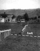
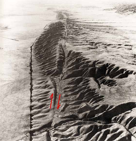
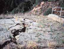
Surface rupture—Fault movements can break the ground surface, damaging buildings and other structures. This fence near Point Reyes was offset 8 feet ( 2.5 m) when the San Andreas Fault moved in the Great (magnitude 7.8) 1906 earthquake (USGS photo).
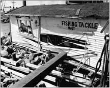
Tsunamis—Great earthquakes occurring anywhere in the Pacific Ocean may displace the ocean floor, generating tsunamis that could affect the California coast. Some coastal communities are designating Tsunami Hazard Zones and planning evacuation routes. Although the tsunami hazard in most of the Bay Area is low, coastal areas are still at risk. For example, this bait shop (Hazel’s Fish Stand) in Half Moon Bay was ruined when it was hit by debris in the tsunami generated by the 1946 (magnitude 8) Alaska earthquake (photo copyright by MS & SB Collection).
![]()
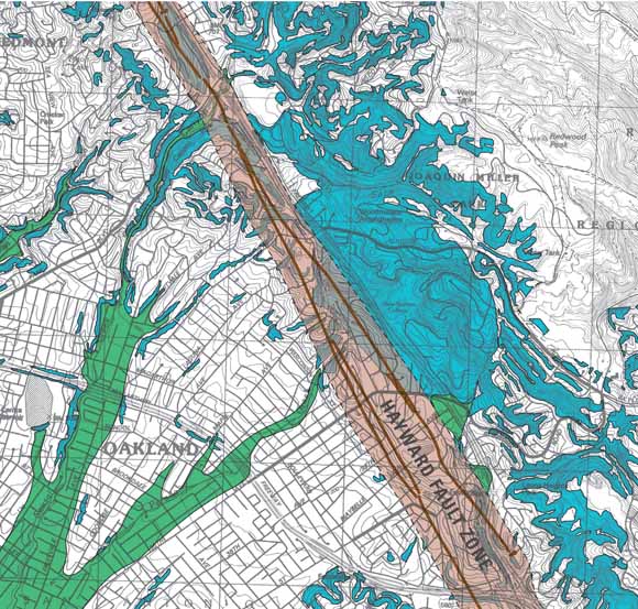
Map Showing Seismic Hazard Zones—This map of part of the Oakland area shows regulatory zones defined by the California Geological Survey (CGS) for three seismic hazards—earthquake-induced landsliding, liquefaction, and surface rupture. These zones indicate where the hazard may exist. Sites of proposed construction (new or remodel) within a zone must be investigated for the hazard. These maps are also used in real-estate transactions—disclosure is required if a property is within any of these hazard zones. CGS seismic hazard zone maps for the Bay Area are available at
The Loma Prieta earthquake released only 3% of the energy of the Great 1906 quake. Although it occurred in the Santa Cruz Mountains, far from the Bay Area’s urban centers, it caused destruction not only in nearby Santa Cruz and Watsonville but also in San Francisco and Oakland:
ShakeMap of the 1989 M 6.9 Loma Prieta Earthquake
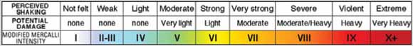
This “ShakeMap” shows levels of shaking in the San Francisco Bay region during the1989 magnitude (M) 6.9 Loma Prieta earthquake. Shaking intensities are shown by colors corresponding to the “Modified Mercalli Intensity Scale,” which uses Roman numerals and is based on actual reports of shaking and damage in earthquakes. ShakeMaps are now automatically generated from shaking measurements recorded by an extensive network of seismographic instruments operated by the partnership organizations in the California Integrated Seismic Network (CISN) (see page 30). CISN ShakeMaps are now available online within minutes after a significant earthquake at http://earthquake.usgs.gov/shakemap/ or http://www.cisn.org/shakemap/.
How Do I Find Out the Expected Shaking in My Neighborhood?
The Association of Bay Area Governments (ABAG) operates a Web site designed to provide this information in the form of earthquake-shaking hazard maps at http://quake.abag.ca.gov/. These maps show expected shaking intensities in the Bay Area for various earthquake scenarios, such as a quake on the Peninsula segment of the San Andreas Fault or the northern Hayward Fault. These maps can be “zoomed in” to display your neighborhood.
Other ABAG earthquake hazard maps show areas of liquefaction susceptibility, landslide hazards, potential fault ruptures, and tsunami inundation. ABAG even has maps for other natural hazards such as wildfires and flooding.
Some words of caution:
What if the Hayward Fault in the East Bay ruptured from San Pablo Bay to Fremont in an earthquake of magnitude 6.9, like Loma Prieta?
If this scenario earthquake for the Hayward Fault occurs, areas of soft soils along the margins of San Francisco Bay, particularly in the East Bay, are likely to experience intense shaking and liquefaction. These areas are heavily urbanized and may have devastation similar to or greater than that of the area around the Cypress freeway structure in Oakland in 1989, shown below.
(USGS photo)
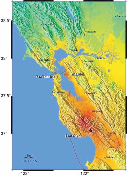
“Scenario” ShakeMap for a Possible M 6.9 Earthquake on the Hayward Fault
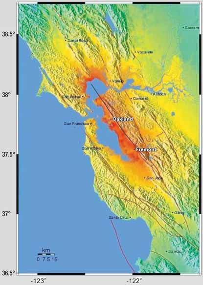

This “scenario” ShakeMap shows predicted levels of shaking in the San Francisco Bay region for a possible magnitude (M) 6.9 earthquake on the Hayward Fault. Such scenario maps are computer generated using information about the projected quake magnitude, distances from the rupturing fault, and local geologic conditions. Scenario ShakeMaps are available online at http://quake.usgs.gov/research/strongmotion/effects/shake/archive/scenario.html.
Projected Consequences and Implications for the Bay Area from a Magnitude 6.9 Earthquake on the Hayward Fault
Source: Association of Bay Area Governments
Where will your family be?
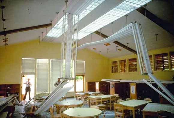
After the 2001 magnitude 6.8 Nisqually earthquake, this school in the Puget Sound area of Washington was closed for repair (Earthquake Engineering Research Institute photo).
Pets are not allowed in most emergency shelters. Do you have a plan to feed and care for your animals after an earthquake? (Photos courtesy of Emergency Animal Rescue Service) |
|
Will you have medical services?
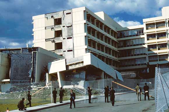
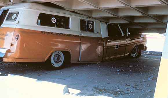
This hospital in Sylmar, California, had to be demolished after the 1971 magnitude 6.7 San Fernando earthquake. Lower photo shows an ambulance that was crushed during the quake. (USGS photos)
Will you be able to get home?
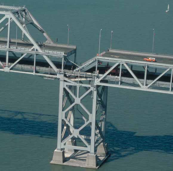
The 1989 magnitude 6.9 Loma Prieta earthquake caused this section of the San Francisco-Oakland Bay Bridge to collapse (USGS photo).
Will you be able to stay in your home?
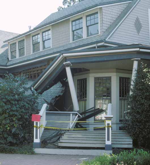
This porch on a wood-frame house failed during the 1989 magnitude 6.9 Loma Prieta earthquake. The “red tag” indicates that this home is unsafe and must not be entered or occupied. (USGS photo)
Can you live without the services you rely on?
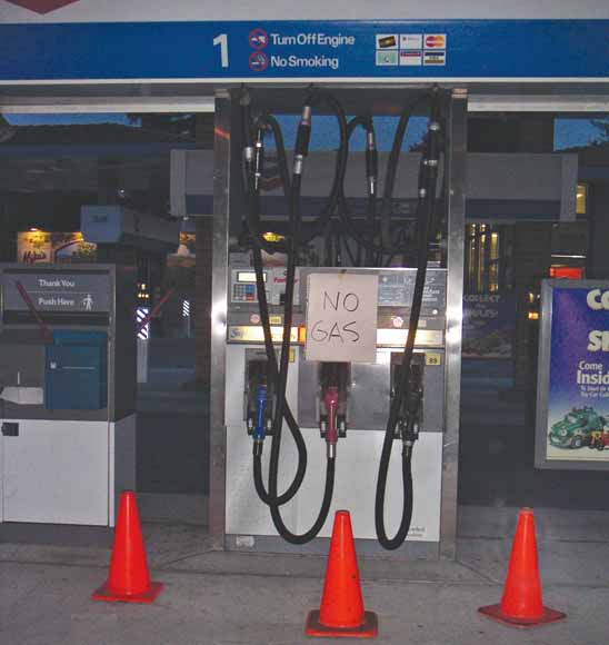
Where will you get your water, food, medicines, and gasoline after an earthquake? (USGS photo)
How will your job be affected?
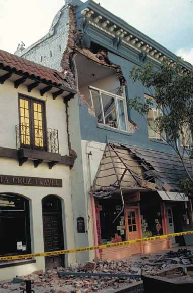
This business in Santa Cruz, California, was nearly destroyed in the 1989 magnitude 6.9 Loma Prieta earthquake (USGS photo).
How Will the American Red Cross Help?
After an earthquake, the American Red Cross will help in the following ways:
For more information go to:
http://www.redcross.org/services/disaster/

Aid may not be immediately available following a major disaster. Without proper planning, the financial impact of an earthquake on you and your family could be devastating. Although many things are out of your control after a quake, your ability to recover financially depends on a number of factors that you can control. Prepare and follow a financial disaster recovery plan and you will be more likely to recover successfully. Consider the following:
|
Don’t be fooled!— Myth number 3 “HOMEOWNER’S INSURANCE WILL COVER ANY DAMAGE TO MY HOME OR BELONGINGS CAUSED BY AN EARTHQUAKE.”
Most residential property insurance policies do not cover damage resulting from earthquakes. A separate earthquake insurance policy is one way to protect your home and the investments you have made in personal belongings. Investigate your options carefully to ensure that your assets are sufficiently protected (see http://www.EarthquakeAuthority.com/). |
Will you have money, food, and medicine?
This store was temporarily closed following the 2001 magnitude 6.8 Nisqually, Washington, earthquake (photo courtesy of The Olympian, Olympia, Wash.).
Will you be able to recover financially?
This bank was damaged in the 2001 magnitude 6.8 Nisqually, Washington, earthquake, requiring customers to seek services elsewhere (photo courtesy of The Olympian, Olympia, Wash.).
Will your insurance cover your losses?
Does your small business have a recovery plan?
These small businesses in Santa Cruz, California, were heavily damaged in the 1989 magnitude 6.9 Loma Prieta earthquake, but both eventually reopened (USGS photo).
What will the Government do for you?
This home in the Santa Cruz Mountains, California, collapsed in the 1989 magnitude 6.9 Loma Prieta earthquake (USGS photo).

Useful Web sites
Financial preparation information:
http://www.redcross.org/services/disaster/0,1082,0_605_,00.html
http://quake.abag.ca.gov/business/
Operation Hope Emergency Financial First Aid Kit (EFFAK):
http://www.operationhope.org/
(Note: Both English and Spanish versions of the EFFAK are available at this site.)
Disaster aid information:
http://www.fema.gov/about/process/
Earthquakes in the Bay Area are inevitable, but damage from them is not! Steps you can take before, during, and after earthquakes will help make you and your family safer and reduce your injuries, damage, and losses:
The seven steps described in this section will help you to be safer in earthquakes. They are arranged as measures you should take before, during, and after quakes. In addition to following the steps at home, they should also be followed at schools and workplaces. If everyone makes an effort to follow these steps, billions of dollars could be saved, injuries avoided, and many deaths averted in the next big earthquake!
You’ve learned your earthquake hazards, now follow these seven steps. . . BEFORE A QUAKE:
STEP 1. Identify potential hazards in your home and begin to fix them (go to step 1).
STEP 2. Create a disaster-preparedness plan (go to step 2).
STEP 3. Create disaster kits (go to step 3).
STEP 4. Identify your building’s potential weaknesses and begin to fix them (go to step 4).
DURING A QUAKE:
STEP 5. Protect yourself during earthquake shaking (go to step 5).
AFTER A QUAKE:
STEP 6. After the quake, check for injuries and damage (go to step 6).
STEP 7. When safe, continue to follow your disaster-preparedness plan (go to step 7).
The first step to earthquake safety is to look around your home and identify all unsecured objects that might fall during shaking.
START NOW by moving heavy furniture, such as bookcases, away from beds, couches, and other places where people sit or sleep! Also make sure that exit paths are clear of clutter.
Simple and inexpensive things that you can do now will help reduce injuries and protect belongings in a quake. Most hardware and home-improvement stores carry earthquake-safety straps, fasteners, and adhesives that you can easily use to secure your belongings.
The following tips describe simple solutions to situations in your home that could be dangerous during earthquake shaking. If these have not yet been done in your home, take action now:
Check List!
Hanging objects
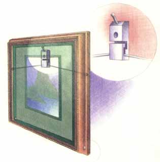
Art and other heavy objects hung on walls may fall, and glass in pictures and mirrors may shatter.
____ Place only soft art, such as unframed posters or rugs and tapestries, above beds or sofas.
____ Hang mirrors, pictures, and other hanging objects on closed hooks.
Objects on open shelves and tabletops
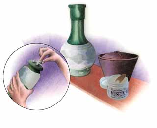
Collectibles and other loose objects can become dangerous projectiles.
____ Hold collectibles, pottery, and lamps in place by using removable earthquake putty, museum wax, or quake gel.
____ Store heavy items and breakables on lower shelves.
Furniture
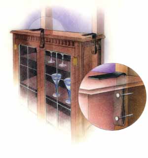
Tall, top-heavy furniture, such as bookcases and entertainment centers, may fall and injure you.
____ Secure both top corners of tall furniture into a wall stud, not just to the drywall.
____ Flexible-mount fasteners, such as nylon straps, allow furniture independent movement from the wall, reducing strain on studs.
Water and gas pipes
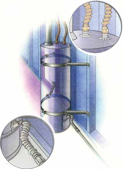
Water or gas pipes anywhere in your home can break. Water leaks can cause extensive damage, and gas leaks are a major fire hazard.
____ Have a plumber evaluate, replace, and properly secure rusted or worn water and gas pipes.
____ If not already done, have a plumber replace rigid gas connections to water heaters, stoves, dryers, and other gas appliances with flexible (corrugated) stainless-steel gas connectors (see below).
____ Excess-flow gas-shutoff valves for individual appliances, which stop gas flow in case of a catastrophic leak, are also now available for use with flexible connectors.
Water heaters
Flexible water connectors, Flexible gas connector
Unsecured water heaters may fall over, rupturing rigid water and gas connections.
____ Water heaters are required to be anchored to wall studs or masonry with metal straps and lag screws. Kits are available at hardware stores and home centers.
____ If not already done, have a plumber install flexible (corrugated) copper water connectors.
In the kitchen
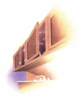
Glassware and china may crash to the floor if cabinet doors are unsecured. Gas appliances can shift, rupturing their gas connections.
____ Secure all cabinets doors, especially those overhead, to help prevent contents from falling out during quakes. Use latches designed for child proofing or earthquake or boat safety.
____ Secure refrigerators and other major appliances to walls using earthquake appliance straps.
In the garage or utility room
Items stored in garages and utility rooms can fall, causing injuries, damage, and hazardous spills or leaks.
____ Move flammable or hazardous materials to low areas that are secure.
____ Ensure that items stored above or beside vehicles cannot fall, damaging or blocking them.
Home electronics
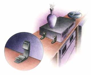
Large electronic devices may fall, causing injuries and damage. They are also costly to replace.
____ Secure TVs, stereos, computers, and microwave ovens with flexible nylon straps and buckles for easy removal and relocation.
For more information on making your home safer in earthquakes go to:
http://quake.abag.ca.gov/housing/
http://quakeinfo.org/
Don’t be fooled!— Myth number 4
“QUAKE INJURIES ARE ALL FROM COLLAPSING BUILDINGS.”
![]()
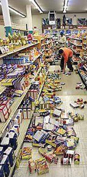
Many people think that all injuries in earthquakes are caused by collapsing buildings. Actually, most injuries in quakes are from objects that break or fall on people. For example, in the 1994 magnitude 6.7 Northridge earthquake, 55% of quake-related injuries were caused by falling objects, such as televisions, pictures and mirrors, and heavy light fixtures.
Move on to STEP 2.
Will everyone in your household know how to react during and after strong earthquake shaking? To be ready for the quakes that are certain to happen in the Bay Area, it is important that your family have a disaster-preparedness plan. Hold occasional earthquake "drills" to practice your plan. Share your disaster plan with your neighbors and discuss key points with babysitters, house sitters, and house guests. Your plan should include most of the following
Plan NOW to be safe during an earthquake:
In a strong earthquake, individual survival skills will be crucial.
Plan NOW to respond after an earthquake:
Doing the following will enable you to help your family and others after a strong quake.
Plan NOW to communicate and recover after an earthquake:
Don’t wait until the next earthquake to do the following.
Move on to STEP 3.
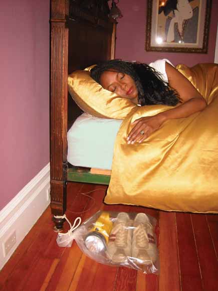
Your family may be sleeping when the next strong quake hits the Bay Area. After the shaking stops, the lights may be out and broken glass and other dangerous debris may litter the floor, making it unsafe to walk barefoot. Keep a flashlight and a pair of sturdy shoes secured to or within reach of everyone’s bed. A good way to do this is to use a drawstring bag tied to a bedpost at the head of the bed for each occupant.
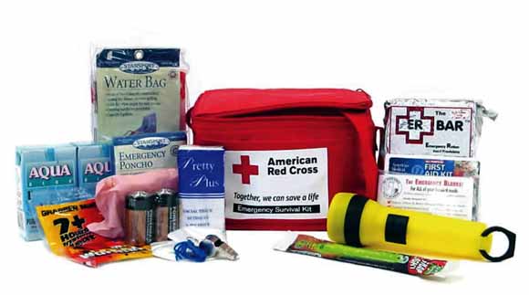
Personal Disaster Kits
Everyone in your family should have their own personal disaster kits. These kits are collections of supplies they may need when a quake strikes, no matter where they are in the Bay Area.
Personalize these kits and keep them where they can easily be reached—at home, in the car, at work or school. A backpack or other small bag is best for these kits so that they can be easily carried in an evacuation. Include the following items:
Household Disaster Kit
Electrical, water, transportation, and other vital systems can be disrupted for several days after a large earthquake. Emergency response agencies and hospitals will likely be overwhelmed and unable to provide you with immediate assistance.
To help your family cope after a strong earthquake, store a household disaster kit in an easily accessible location, preferably outdoors (not in your garage). This kit, which complements your personal disaster kits, should be in a large watertight container that can be easily moved and should hold at least a 3- to 5-day supply of the following items:
NOTE: Replace perishable items like water, food, medications, and batteries on a yearly basis.
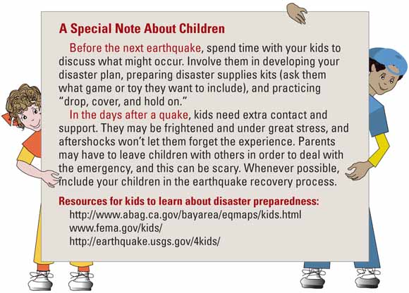
A Special Note About Children
Before the next earthquake, spend time with your kids to discuss what might occur. Involve them in developing your disaster plan, preparing disaster supplies kits (ask them what game or toy they want to include), and practicing “drop, cover, and hold on.”
In the days after a quake, kids need extra contact and support. They may be frightened and under great stress, and aftershocks won’t let them forget the experience. Parents may have to leave children with others in order to deal with the emergency, and this can be scary. Whenever possible, include your children in the earthquake recovery process.
Resources for kids to learn about disaster preparedness:
http://www.abag.ca.gov/bayarea/eqmaps/kids.html
www.fema.gov/kids/
http://earthquake.usgs.gov/4kids/
For more information on earthquake preparedness plans and disaster kits go to:
Telephone book:
The front section of your local phone book
American Red Cross:
http://www.redcross.org/services/disaster/beprepared/http://redcrossshop.org/
Pacific Gas & Electric:
http://www.pge.com/education_training/
Move on to STEP 4.
Is your house, condo, or apartment strong enough to withstand an earthquake?
If you live in a single-family home or duplex...
You can use the quiz at right to see if your home is likely to be so badly damaged in a future quake that people might be injured or that it would be unsafe to occupy.
If your home scores 13 or more points on the quiz, you probably should have a structural engineer, architect, or contractor evaluate it unless it has been strengthened in the last few years. They will check to see if it is strong enough to keep you and your family reasonably safe in a quake. For example:
Once you determine if your home needs retrofitting, identify problems, prioritize how and when to fix them, and get started!
The latest recommendations of structural engineers, contractors, and city building officials who are experts on retrofitting are available on the ABAG web site at http://quake.abag.ca.gov/fixit/.
Strengthening your crawl space
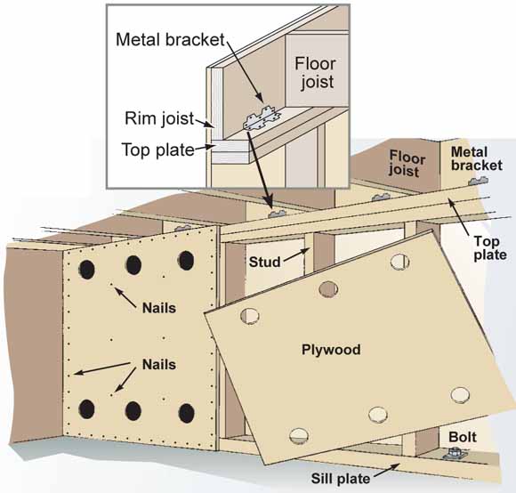
The number of foundation bolts, linear feet of plywood, and floor-to-wall connections (brackets) that are required to seismically retrofit your home varies depending on its size and weight. Remember, earthquakes will find the weak spots in your house. So, if you add bolts but not plywood, you will still have a problem when the ground shakes!
Structural-Safety Quiz for Single-Family Home or Duplex
If you live in a single-family home or duplex, the strength of your home depends on when it was built, its style of construction, and its location.
1. When was your home built?
2. How tall is your home?
3. How hard is the ground likely to shake under your home?
TOTAL POINTS =_____
If your home scores 13 or more points on the quiz, you probably should have an engineer, architect, or contractor evaluate it unless it has been strengthened in the past few years.
If you live in a condominium or apartment...
Many condominiums and apartments have parking on the ground floor. These weak or “soft” first stories may lean or collapse in an earthquake.
Some multi-story buildings in the Bay Area can have problems because they were constructed before 1972 of concrete or brick that is inadequately reinforced. Many cities have requirements that these buildings be seismically retrofitted. You are less likely to be killed in a retrofitted building, but you may not be able to reoccupy it after a quake.
The “soft” first story of this apartment building collapsed in the 1994 magnitude 6.7 Northridge earthquake, crushing cars below and severely damaging the floors above (FEMA photo).
As a renter, ask your landlord these questions:
Go to http://quake.abag.ca.gov/fixit/ to take a quiz to see if your apartment building or condominium may need retrofitting. This Web site also has links to information that can help your landlord find appropriate ways to improve the strength of your building.
If you live in a mobile home...
Look under your home. If you only see a metal or wood “skirt” on the outside with concrete blocks or steel tripods or jacks supporting your home, you need to have an “engineered tie-down system” or an “earthquake-resistant bracing system” (ERBS) installed.
An ERBS should have a label on the bracing that says, “Complies with the California Administrative Code, Title 25, Chapter 2, Article 7.5.”
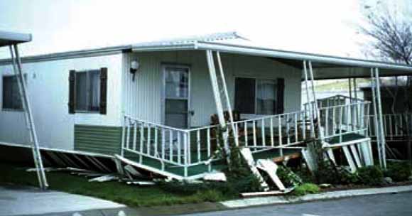
Mobile home damage in the 1980 magnitude 5.8 Livermore earthquake (photo courtesy NISEE).
Brick chimneys can collapse if shaken...
Stay away from chimneys and fireplaces during shaking! Collapsing chimneys cause many injuries in earthquakes—60,000 chimneys fell in the 1994 magnitude 6.7 Northridge earthquake.
You can reduce the chance of bricks falling through a sheetrock ceiling in a quake by putting sheets of plywood above ceiling framing. However, “retrofitting” masonry chimneys with bracing or strapping is not an effective safety measure, because they may still fall as a unit when exposed to strong shaking.
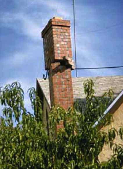
This chimney broke and nearly fell in the 1969 magnitude 5.6 Santa Rosa earthquake (photo courtesy NISEE).
Move on to STEP 5.
Don’t be fooled!— Myth number 5
“WE HAVE GOOD BUILDING CODES, SO WE MUST HAVE SAFE BUILDINGS.”
![]()
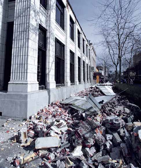
The best building code in the world does nothing for buildings built before the code was enacted. Although building codes used in California have some of the strictest seismic provisions in the world, many older buildings have not been “retrofitted” to meet updated codes. Retrofitting—fixing problems in older buildings—is the responsibility of a building’s owner.
“DROP, COVER, AND HOLD ON”
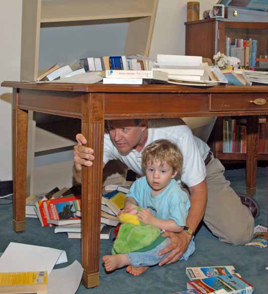
If you are indoors, when you feel strong earthquake shaking, drop to the floor, take cover under a sturdy desk or table, and hold on to it firmly until the shaking stops.
The previous pages have concentrated on getting you ready for future earthquakes in the Bay Area, but what should you do when the shaking starts?
If you are indoors...
In bed
Hold on and stay there, protecting your head with a pillow. You are less likely to be injured staying where you are. Broken glass on the floor can cause injuries; be sure to put shoes on before stepping on the floor (see STEP 2)!
In a high rise building
DROP, COVER, AND HOLD ON. Avoid windows and other hazards. Do not use elevators. Do not be surprised if sprinkler systems or fire alarms activate.
At work
DROP, COVER, AND HOLD ON. Know your workplace’s earthquake safety plan and put it into action. When safe, move to a specified meeting location.
In a public building or theater
DROP, COVER, AND HOLD ON if possible. If in a theater seat, duck down and protect your head and neck with your arms. Don’t try to leave until the shaking is over. Then walk out slowly, watching for fallen debris or anything that could fall on you in aftershocks.
If you are outdoors...
Move to a clear area if you can safely do so; avoid buildings, powerlines, trees, and other hazards. Always assume fallen powerlines are live!
Near tall buildings
Windows, facades, and architectural details are often the first parts of a building to collapse. Get away from this danger zone when shaking starts. Take refuge in a safe building or an open space.
Driving
When able, safely pull over to the side of the road, stop, and set the parking brake. Avoid overpasses, bridges, powerlines, signs, trees, and other things that might collapse or fall on the vehicle. Stay inside the vehicle until the shaking is over. If a powerline falls on the vehicle, stay inside until a trained person removes the hazard.
In a stadium
Stay at your seat and protect your head and neck with your arms. Don’t try to leave until the shaking is over. Then exit slowly, avoiding debris and watching for anything that could fall in aftershocks.
Near the shore
Tsunamis from local earthquakes may flood low-lying coasts within minutes of the quake. Distant, large earthquakes can produce tsunamis that may arrive hours later at California’s beaches. If you feel a strong quake, hear a tsunami warning, or notice the water suddenly withdrawing from the beach, evacuate immediately to higher ground. Tsunami waves may continue to arrive for hours, so do not return to the shore until an “all clear message” has been issued. For more tsunami survival tips go to https://pubs.usgs.gov/circ/c1187/.
Below a dam
Dams can fail during a major earthquake. Catastrophic failure is unlikely, but if you are downstream from a dam, you should know flood-zone information and have prepared an evacuation plan. For more information go to the Association of Bay Area Governments Web site at http://www.abag.ca.gov/bayarea/eqmaps/eqfloods/floods.html.
Don’t be fooled!— Myth number 6
“HEAD FOR THE DOORWAY”
![]()
In the early days of California, many homes were made of adobe bricks with wooden doorframes. After a powerful earthquake, doorframes were sometimes only parts of these houses still standing. From this came the myth that a doorway is the safest place to be during an earthquake. Today, few people in the Bay Area live in old, unreinforced adobe houses. In modern houses, doorways may be no stronger than any other part of the house and do little to protect you from falling debris. You are safer under a table, so “DROP, COVER, AND HOLD ON.”
Once earthquake shaking has stopped, follow your disaster preparedness plans (see Step 2). Most importantly:
Check for injuries
NOTE: The manual in your first aid kit and the front pages of your telephone book have instructions on first aid measures.
Check for damage causing hazardous conditions
If your home is seriously damaged...
If your home is structurally unsafe or threatened by a fire or other secondary disaster, you need to evacuate. However, shelters may be overcrowded and initially lack basic services, so do not leave home just because utilities are out of service or your home and its contents have suffered moderate damage.
If you evacuate, tell a neighbor and your family point-of-contact where you are going. Take the following, if possible, when you evacuate:
Bring to a shelter
However, do not bring
Move on to STEP 7.
Related Web links:
American Red Cross
http://www.redcross.org/
http://www.prepare.org/
Association of Bay Area Governments
http://quake.abag.ca.gov/
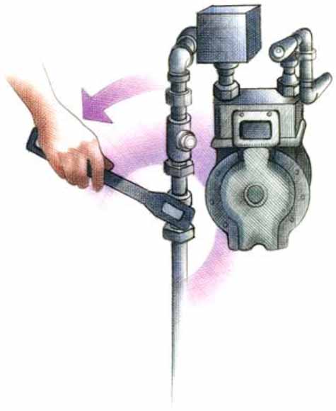
If you suspect a gas leak, use a manual gas shut off wrench.
Once you have met your and your family’s immediate needs after the next strong Bay Area earthquake, continue to follow your disaster-preparedness plan (see Step 2).
The first days after the earthquake. . .
In the days following a damaging quake, pay special attention to the following:
Safety first
Do not reenter your home until you know it is safe.
Be in communication
Check your food and water supplies
The first weeks after the earthquake. . .
This is a time of transition. Although aftershocks may continue, you will now work toward getting your life, your home and family, and your routines back in order. Emotional care and recovery are just as important as healing physical injuries and rebuilding a home. Make sure your home is safe to occupy and not in danger of collapse in aftershocks. If you were able to remain in your home or return to it after a few days, you will have a variety of tasks to accomplish while reestablishing routines:
Tasks
If you cannot stay in your home...
The American Red Cross (ARC) offers immediate emergency assistance with housing needs. ARC also supports shelter operations prior to a Presidential declaration of a Federal disaster.
Once a Presidential declaration has been issued, the Federal Emergency Management Agency (FEMA) may activate the “Assistance for Individuals and Households Program.” This program includes:
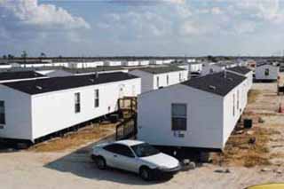
FEMA mobile homes being set up in Port Charlotte, Florida, to provide temporary housing for victims of Hurricane Charley (August 2004). Nearly a year after the storm, these trailers were still being used. (FEMA photo.)
Don’t be fooled!— Myth number 7
“I DON’T NEED TO WORRY ABOUT EARTHQUAKES—THE GOVERNMENT WILL SAVE ME!”
![]()
Many people wrongly believe that the U.S. Government will take care of all their financial needs if they suffer losses in an earthquake. The truth is that Federal disaster assistance is only available if the President formally declares a disaster. Even if you do get disaster assistance, it is usually a loan that you must repay, with interest, in addition to mortgages and other financial obligations you still owe, even on damaged property. If you don’t qualify for loans, grants may be available to you. However, these are only designed to meet your most immediate needs, not to replace your losses (see Finance section).
For help in the first week after an earthquake—contact:
Your county office of emergency services
American Red Cross
http://www.redcross.org/services/disaster/
1-866-GET-INFO (438-4636)
Govenor’s Office of Emergency Services (OES)
http://www.oes.ca.gov/
Federal Emergency Management Agency (FEMA)
http://www.fema.gov/about/process/
Following a quake, disaster aid may not be immediately available, so you should plan ahead. If you have prepared a financial disaster recovery plan, you are more likely to recover successfully after a quake. Financial recovery planning resources are available from:
Your financial disaster recovery kit
After a damaging earthquake, you will need copies of essential financial documents, as well as emergency cash. Keep these items together, current, and stored in a fire-proof document safe. Consider purchasing a home safe or renting a safe deposit box. Some essential items in your financial disaster recovery kit are:
After an earthquake, knowing more about what just happened can reduce fears and help you understand what to expect next. Online earthquake information products include:
Location and magnitude of recent earthquakes
Within 1 to 2 minutes of an earthquake, its location and magnitude are available at several Web sites, including
http://earthquake.usgs.gov/ and
http://quake.usgs.gov/recenteqs/latest.htm.
“ShakeMap”
Within 5 to 10 minutes of most felt earthquakes (magnitude 3.5 and greater) in the Bay Area, a “ShakeMap” is posted on the Web. This map shows the range of shaking intensities across a region. Every quake has only a single magnitude, but it produces a range of shaking intensity values over the area in which it is felt.
ShakeMaps use data from seismic instruments to provide a rapid picture of where the strongest shaking occurred. These maps help to identify areas where a quake’s impact is greatest and are used by emergency managers to speed disaster response. ShakeMaps are available at
http://www.cisn.org/shakemap.html
or
http://earthquake.usgs.gov/shakemap/
.
“Did You Feel It?”—Tell us what you felt!
Personal experiences of the effects of an earthquake are very valuable to scientists. When you have felt a quake, please report your observations by using a quick survey found on the U.S. Geological Survey “Did You Feel It?” Web site at
http://pasadena.wr.usgs.gov/shake/ca/.
When you fill out this online survey, your observations of actual damage and shaking are combined with those of thousands of other people. The quake’s shaking intensities, derived from these observations, are displayed by ZIP code on a “Community Internet Intensity Map.”
Who monitors California’s earthquakes?
Earthquake monitoring for California is done by the California Integrated Seismic Network (CISN), a partnership among the U.S. Geological Survey (USGS), University of California Berkeley, Caltech, the California Geological Survey, and the Governor’s Office of Emergency Services. CISN is part of a USGS national seismic-monitoring program called the Advanced National Seismic System (ANSS).
For more information go to:
http://www.cisn.org/
http://www.anss.org/
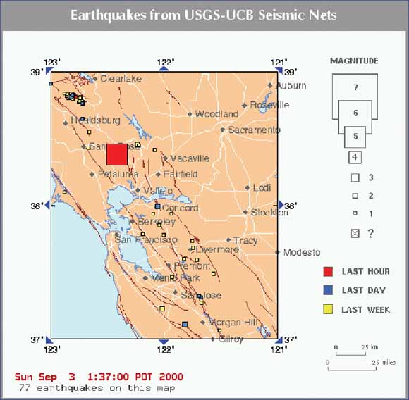
Map of recent earthquakes in the San Francisco Bay region, just after the September 3, 2000 magnitude 5.2 Yountville (Napa) earthquake.
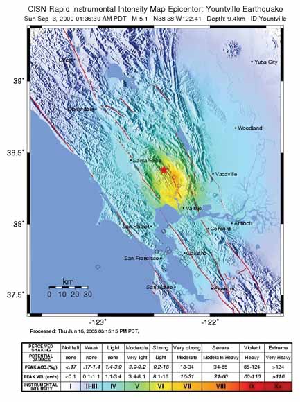
“ShakeMap” for the 2000 magnitude 5.2 Yountville (Napa) earthquake. The strongest shaking was not centered on the quake, but to the south in the soft soils of the Napa River Valley.
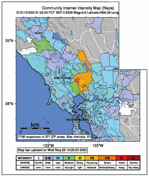
Community Internet Intensity Map (“Did You Feel It?”) for the 2000 magnitude 5.2 Yountville (Napa) earthquake. More than 7,700 people reported their observations on this quake online.
Aftershock. Earthquakes that follow the largest shock of an earthquake sequence. They are smaller than the “mainshock” and can occur over a period of weeks, months, or years. In general, the larger the mainshock, the larger and more numerous the aftershocks and the longer they will continue.
Creep. Slow, more or less continuous movement occurring on some faults. Creep does not cause shaking.
Earthquake. Ground shaking caused by a sudden movement on a fault or by volcanic disturbance.
Epicenter. The point on the Earth’s surface above the point at depth in the Earth’s crust where an earthquake begins.
Fault. A fracture or crack along which two blocks of rock slide past one another. This movement may occur rapidly, in the form of an earthquake, or slowly, in the form of creep.
Foreshock. An earthquake that precedes the largest quake (“mainshock”) of an earthquake sequence. Foreshocks may occur seconds to weeks before the mainshock.
Intensity. A measure of ground shaking describing the local severity of an earthquake in terms of its effects on the Earth’s surface and on humans and their structures. The Modified Mercalli Intensity (MMI) scale, which uses Roman numerals, is one way scientists measure intensity.
Landslide. A mass movement of soil, mud, and (or) rock down a slope.
Liquefaction. The process that occurs when an earthquake shakes wet sandy soil until it behaves like a liquid, allowing sand to “boil up” to the surface, buildings to sink, or sloping ground to move.
Magnitude (M). A number that represents the size of an earthquake source, as determined from seismographic observations. The original earthquake magnitude scale was the Richter or “local” scale (ML), defined by Charles Richter in 1935, but it has limited range and applicability. Modern magnitude scales are based on the area of fault rupture times the amount of slip (seismic moment).The moment magnitude (MW) is the preferred magnitude scale, as it provides the most reliable estimate of the size of the largest quakes. For smaller quakes, ML and MW values are nearly the same. An increase of one unit of moment magnitude (for example, from 4.6 to 5.6) corresponds approximately to a 31.6-fold increase in energy released [by definition, a two-unit increase in magnitude —for example, from 4.7 to 6.7—represents an increase in energy released of 1,000 times (31.6_31.6)]. Quakes below magnitude 2.5 are not generally felt by humans.
Plate tectonics. The scientific theory that the Earth’s outer shell is composed of several large, thin, relatively strong “plates” that move relative to one another. Movements on the faults that define plate boundaries produce most earthquakes.
Retrofit. Strengthening an existing structure to improve its resistance to the effects of earthquakes.
Rupture zone. The area of the Earth through which fault movement occurred during an earthquake. For large quakes, the section of the fault that ruptured may be several hundred miles in length. Ruptures may or may not extend to the ground surface.
Seismic hazard. The potential for damaging effects caused by earthquakes. The level of hazard depends on the magnitude of likely quakes, the distance from the fault that could cause quakes, and the type of ground materials at a site.
Seismic risk. The chance of injury, damage, or loss resulting from seismic hazards. There is no risk, even in a region of high seismic hazard, if there are no people or property that could be injured or damaged by a quake.
Soft story. A building story that has significantly less stiffness than the story above. Some buildings with parking at ground level (and thus fewer walls or columns) or an otherwise open ground story have this condition. The term is sometimes also applied to a story that has less strength than the one above, a condition that is more precisely termed a “weak story.”
Strike-slip fault. A generally vertical fault along which the two sides move horizontally past each other. The most famous example is California’s San Andreas Fault.
Subduction zone. A boundary along which one plate of the Earth’s outer shell descends (subducts) at an angle beneath another. A subduction zone is usually marked by a deep trench on the sea floor. An example is the Cascadia Subduction Zone offshore of Washington, Oregon, and northern California. Most tsunamis are generated by subduction-zone earthquakes.
Tsunami. A sea wave of local or distant origin that results from large sea-floor displacements associated with powerful earthquakes, major submarine landslides, or exploding volcanic islands.
U.S. Department of the Interior
Gale A. Norton, Secretary
U.S. Geological Survey
P. Patrick Leahy, Acting Director
Any use of trade, product, or firm names in this publication is for descriptive purposes only and does not imply endorsement of the U.S. Government.
United States Government Printing Office: 2005
Revised and reprinted, March 2006
For additional copies please contact:
USGS Information Services
Box 25286
Denver, CO 80225
For more information about the USGS and its products:
Telephone: 1-888-ASK-USGS (1-888-275-8747)
World Wide Web: http://www.usgs.gov/
Manuscript approved for publication, July 19, 2005
Cataloging-in-publication data are on file with the Library of Congress (URL http://www.loc.gov/).
This document is adapted from editions of “Putting Down Roots in Earthquake Country,” written by Lucy Jones (U.S. Geological Survey) and Mark Benthien (Southern California Earthquake Center), published by the Southern California Earthquake Center (SCEC) in 1995, 2004, 2005 (see http://www.earthquakecountry.info/roots/).
Disclaimer: The suggestions and illustrations included in this document are intended to improve earthquake awareness and preparedness; however, they do not guarantee the safety of an individual or a structure. The contributors and sponsors of this handbook do not assume liability for any injury, death, property damage, or other effects of an earthquake.
CONTRIBUTORS: U.S. Geological Survey: Mary Lou Zoback, Steve Walter, Susan Garcia, Luke Blair, Marco Ticci, Howard Bundock, and Bob Simpson; American Red Cross: Harold Brooks, Helen Knudson, and Chris Kramer; Association of Bay Area Governments: Jeanne Perkins; California Earthquake Authority: Nancy Kincaid and Rolf Erickson; California Geological Survey: Keith Knudsen and Chris Wills; Earthquake Engineering Research Institute, Northern California Chapter: Fred Turner; Governor’s Office of Emergency Services: Richard Eisner and Kathleen Bailey; QuakeHold!: Dean Reese and Jeff Primes; San Francisco Office of Emergency Services and Homeland Security: Doug Sandy; Southern California Earthquake Center: Mark Benthien and Robert de Groot; Structural Engineers Association of Northern California: Patricia Coate and Reinhard Ludke; University of California, Berkeley Seismological Laboratory: Lind Gee; U.S. Department of Homeland Security, Federal Emergency Management Agency: Jeffrey Lusk.
Text edited by James W. Hendley II and Peter H. Stauffer, USGS.
Production, design, and illustration by Susan Mayfield, USGS.
Web design by Michael Diggles, USGS.
Other illustrators: Jere Smith (front cover), Stephanie Langley (p. 4, 10, 25, 26), Todd Connor (p. 20, 21, 27), and Judy Weathers (USGS) (p. 9, 23, 24).
For links to many useful Web sites go to: http://earthquake.usgs.gov/learn/preparedness.php
For the Southern-California version of this handbook, go to: http://www.earthquakecountry.info/roots/
USGS General Information Product 41, Protecting Your Family From Earthquakes—The Seven Steps to Earthquake Safety is a summary of this book in English and Spanish.
USGS General Information Product 42, Protecting Your Family From Earthquakes—The Seven Steps to Earthquake Safety is a summary of this book in English, Chinese, Vietnamese, and Korean.
Download this handbook as a 32-page PDF file (gip-15.pdf; 5.8 MB)
 Visit the 1906 Earthquake Centennial Alliance.
Visit the San Francisco Bay Region Geology and Geologic Hazards website.
Visit the Earthquake Hazards Program – Northern California website.
| Help
| PDF help
| Publications main page | General Information Products |