
Published in commemoration of the 100th anniversary of the 1906 earthquake
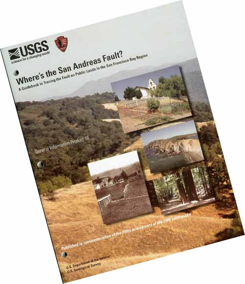
View looking southeast along the straight valley of Upper Stevens Creek. The stream valley roughly follows the trace of the San Andreas Fault in the central Santa Cruz Mountains. Insets show (top) the San Andreas Fault scarp at Mission San Juan Bautista, (left middle) a historical photograph of a fence in Olema offset by the 1906 earthquake, (right middle) granitic sea cliffs of the Point Reyes headlands west of the fault, and (bottom) redwood trees growing along the fault in Sanborn County Park in Santa Clara County.
|
This volume is a general geology field guide to the San Andreas Fault in the San Francisco Bay region. Before going out in the field, it is recommended that you read the chapter about your target destination and make note of the specific features you wish to see. Examine directions and maps so you can focus on driving while making observations about the surrounding landscape. Depending on your destination, check on weather, tides, and road conditions. Geologic maps are available for all areas described in each field-trip chapter. This first chapter provides a brief overview of the San Andreas Fault in context to regional earthquake history and geology with emphasis of the section of the fault that ruptured in the Great San Francisco earthquake of 1906. This first section also contains earthquake information and discussions about making field observations of fault-related landforms, landslides and mass-wasting features, and the plant ecology in the San Francisco Bay region. The remainder of the volume is a collection of selected field-trip stops and recommended hikes on public lands in the Santa Cruz Mountains, along the San Mateo Coast, and at Point Reyes National Seashore. These trips focus on public-accessible locations along the San Andreas Fault and associated faults and on significant rock exposures and landforms. Note that more stops are provided in each of the sections than might be possible to visit in a day. This extra material is intended to provide optional choices to visit in a region with a wealth of natural resources. Selected references provide a more technical and exhaustive overview of the fault system and geology in the San Francisco Bay region. Although this resource is intended as an introductory guide, some discussions contain more technical information necessary to maintain scientific accuracy. A limited glossary at the front of the guide is provided for frequently used terms. A review of a basic high-school or introductory college Earth science or geology textbook would be useful for individuals who have not taken or had an introductory geology course. An important companion publication about earthquake awareness and safety that everyone living in the region should see is Putting Down Roots In Earthquake Country—Your Handbook For The San Francisco Bay Region (https://pubs.usgs.gov/gip/2005/15/). More information about the San Andreas Fault, earthquakes, and regional of geology of California can be found on the U.S. Geological Survey (USGS) website at http://www.usgs.gov. |
Get the Guidebook now. (142 pages; 52 MB PDF file) Includes new first and second chapters.
Cover and Introduction (36 pages; 5.7 MB PDF file). Revised 2010
Hollister and San Juan Bautista (14 pages; 1 MB PDF file). Revised 2010
South Bay including Lexington Reservoir & Loma Prieta, Forest of Nisene Marks, lyndon Canyon & Lake Ranch Reservoir, and Sanborn County Park (32 pages; 16 MB PDF file)
Peninsula including Skyline Ridge and San Mateo County (31 pages; 14.5 MB PDF file)
Point Reyes National Seashore; including back cover with index map (28 pages; 18.3 MB PDF file)
For questions about the content of this report, contact Phil Stoffer

You can download a free copy of the latest version of Adobe Reader.
| Help
| PDF help
| Publications main page |
| Western General Information Products |
|
Geologic Division
| Earthquake Hazards Program
|
This report with the two revised chapters is available only on the Web.