Within a few seconds after the onset and mobilization of the debris avalanche, the climactic eruptions of May 18 began as the sudden unloading of much of the volcano's north flank abruptly released the pent-up pressure of the volcanic system. The sudden removal of the upper part of the volcano by the landslides triggered the almost instantaneous expansion (explosion) of high temperature-high pressure steam present in cracks and voids in the volcano and of gases dissolved in the magma that caused the bulge of the cryptodome. The abrupt pressure release, or "uncorking," of the volcano by the debris avalanche can be compared in some ways to the sudden removal of the cap or a thumb from a vigorously shaken bottle of soda pop, or to punching a hole in a boiler tank under high pressure.
At Mount St. Helens, the "uncorking" unleashed a tremendous, northward-directed lateral blast of rock, ash, and hot gases that devastated an area of about 230 square miles in a fan-shaped sector north of the volcano. To the south, the devastated area was much less, extending only a small distance downslope from the summit. Along with older volcanic debris, the blast also included the first magmatic material erupted by Mount St. Helens, indicating that the landslides and the ensuing blast had exposed the cryptodome magma.
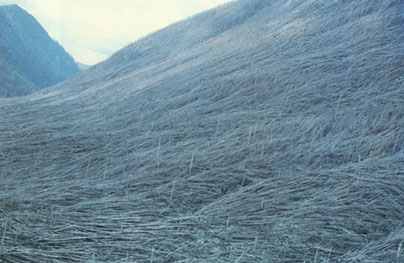
What appear to be blades of mown grass are actually large trees, some over 100 feet tall, flattened by the tremendous force of the lateral blast, even out to distances as far as 19 miles from the volcano (Photograph by Daniel Dzurisin).
Although the lateral blast began some seconds later than the debris avalanche, the blast's velocity was much greater, so that it soon overtook the avalanche. Calculations have shown that the blast's initial velocity of about 220 miles an hour quickly increased to about 670 miles an hour. The average velocity did not surpass the speed of sound in the atmosphere (about 735 miles an hour). This observation is consistent with the lack of reports of loud atmospheric shocks or "sonic booms" from nearby observers such as Keith and Dorothy Stoffel in the light plane or survivors on the ground. In some areas near the blast front, however, the velocity may have approached, or even exceeded, the supersonic rate for a few moments.
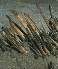 The splintered and charred remains
of a tree removed in the direct blast zone. In this picture, the direction
of the blast was from right to left. Tree trunk was originally about 2 feet
in diameter (Photograph by Robert Smith).
The splintered and charred remains
of a tree removed in the direct blast zone. In this picture, the direction
of the blast was from right to left. Tree trunk was originally about 2 feet
in diameter (Photograph by Robert Smith).
The blast was widely heard hundreds of miles away in the Pacific Northwest, including parts of British Columbia, Montana, Idaho, and northern California. Yet, in many areas much closer to Mount St. Helens--for example, Portland, Oregon, only 50 miles away--the blast was not heard. Subsequent studies by the Oregon Museum of Science and Industry demonstrated a so-called "quiet zone" around Mount St. Helens, extending radially a few tens of miles, in which the eruption was not heard. The creation of the "quiet zone" and the degree to which the eruption was heard elsewhere depended on the complex response of the eruption sound waves to differences in temperature and air motion of the atmospheric layers and, to a lesser extent, local topography.
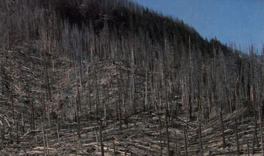
Border area of the lateral-blast zone. Dead trees of the "seared zone" (middle ground) stand between the flatteded trees of the "tree-down zone" (foreground) and unaffected forest (upper right) (Photograph by Lyn Topinka in April 1982).
The near-supersonic lateral blast, loaded with volcanic debris, caused widespread devastation as far as 19 miles from the volcano. The area affected by the blast can be subdivided into three roughly concentric zones:

Generalized map showing the lateral-blast zones.
A similar, but narrower and northeast-trending, strong laterally directed
explosion occurred at Mount St. Helens about 1,100 years ago. The blast
of May 18, 1980, however, traveled at least three times as far as the 1,100-year-old
blast. Thus, the occurrence of a lateral blast such as that of May 18 was
not the first in Mount St. Helens' history, but its power and resulting
destruction were unprecedented. The lateral blast, debris avalanche, and
associated mudflows and floods caused most of the casualties and destruction
on May 18; the adverse impact of volcanic ash fallout downwind was minor
by comparison.

URL: <https://pubs.usgs.gov/gip/msh/lateral.html>
Contact: John Watson
Last updated: 06.25.97