BASIN AND RANGE AQUIFERS
INTRODUCTION
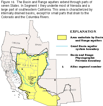
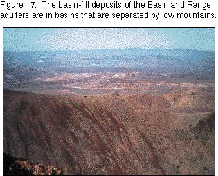
The part of Segment 1 east of the Southern Cascade Mountains, the Sierra Nevada, and the smaller mountain ranges east of the Los AngelesSan Diego area is called the Basin and Range Physiographic Province (fig. 16) and contains three principal aquifer types collectively referred to as the "Basin and Range aquifers." These aquifers underlie most of Nevada and parts of eastern and southern California, western Utah, southern Arizona, southwestern New Mexico, and southern Oregon and Idaho; their extent is approximately, but not exactly, the same as that of the physiographic province. The aquifers are formed of volcanic and carbonate rocks and unconsolidated to consolidated basin-fill deposits. The basin-fill deposits form the most productive aquifers and are generally in individual alluvial basins that are drained internally and are separated by low mountains (fig. 17). Except for small areas that drain to the Colorado River, no streams that rise within the Basin and Range Province carry water to the oceans. Practically all the precipitation that falls in the area is returned to the atmosphere by evapotranspiration, either directly from the soil or from the lakes and playas that occupy the lowest points within the basins and that are discharge areas for the alluvial aquifers.
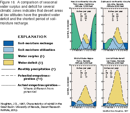
The Basin and Range Province is the most arid area in the Nation; the potential annual water loss through evapotranspiration exceeds the annual water gain from precipitation even at the higher elevations (fig. 18). Clear skies and low humidity cause extreme daily and seasonal temperature ranges as the sparsely covered land surface is heated quickly by solar radiation and then rapidly cools at nightfall. In more humid climates, the denser vegetative cover uses energy derived from solar radiation to drive the process of evapotranspiration, thus moderating diurnal and seasonal temperature variations.
Each of the large desert basins has an area where the land slopes toward a central depression, and each has a main drainageway that is dry most of the time. Many of the valleys have playas in their lowest depressions (fig. 19). The playas are left by the evaporation of intermittent lakes. Parts of some of the valleys have become encrusted to a depth of several inches with alkaline salts, which cover the surface as a powdery crust. However, in some valleys, permanent lakes that have no outlets are fed by surface drainage and contain saline or alkaline water, produced when dissolved minerals are concentrated by evaporation of the lake water.
GEOHYDROLOGIC UNITS
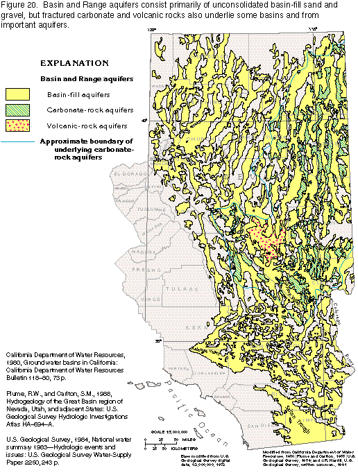
Within the Basin and Range Province, aquifers are not continuous, or regional, because of the complex faulting in the region. Three principal aquifer types collectively called the Basin and Range aquifers in this report are volcanic-rock aquifers, which are primarily tuff, rhyolite, or basalt of Tertiary age; carbonate-rock aquifers, which are primarily limestones and dolomites of Mesozoic and Paleozoic age; and basin-fill aquifers, which are primarily unconsolidated sand and gravel of Quaternary and Tertiary age (fig. 20). Any or all three aquifer types may be in, or underlie, a particular basin and constitute three separate sources of water; however, the aquifers may be hydraulically connected to form a single source. Other rock types within the region have low permeability and act as boundaries to the flow of fresh ground water. The aquifers in the Great Basin part of the Basin and Range Province (fig. 16) were studied as part of the U.S. Geological Survey's Regional Aquifer-System Analysis (RASA) Program.
Volcanic-Rock Aquifers
The volcanic-rock aquifers (fig. 20)
can be separated into three categories-welded tuffs, bedded tuffs,
and lava flows. The different characteristics for the storage
and transmission of water in each category depend on the presence
of primary and secondary porosity. Physical characteristics that
affect the movement of ground water include the number and degree
of interconnection of joints, the relation of joint density to
degree of welding and compaction, the horizontal partings within
tuffs, the development of rubble zones between lava flows, and
the interconnection of vesicles in the lavas.
Ash-flow tuffs are consolidated deposits of volcanic ash, which were emplaced by flowage of a turbulent mixture of gas and pyroclastic materials. Ash-flow deposits consist principally of glass shards and pumice fragments that are usually less than 0.15 inch in length, although some flows consist of ejecta of larger size. Typically, the deposits are nonsorted and do not exhibit bedding, in contrast with the generally pronounced bedding of ash-fall tuff deposits. In general, ash flows are tens of feet thick, but some are only a few feet thick, whereas others are hundreds of feet thick. After emplacement of an ash flow, compaction or welding of the ash can result in an average 50-percent reduction in the porosity of the original flow.
Welding within a single ash flow is variable, and each ash flow can be categorized by three distinct orders of welding-none, partial, or dense. Commonly, a zone of dense welding is underlain and overlain by zones of partial welding, which are, in turn, underlain and overlain by zones of no welding (fig. 21). However, in some thin, exceptionally hot flows, the entire unit of tuff can be densely welded. The degree of welding directly affects the interstitial porosity of the ash-flow tuff. In the nonwelded base or top of a fresh ash flow, the interstitial porosity can be greater than 50 percent; in the densely welded part, it can be less than 5 percent.
Columnar jointing characterizes the zones of dense and partial welding; these joints form in response to tensional forces that develop as the flow cools. Columnar-joint spacings range from a few tenths of an inch to many feet; the more closely spaced joints are usually in the zone of most intense welding. The joints are usually vertical, but departures from the vertical are common. Cooling joints are not common in the nonwelded parts of the ash flow (fig. 21).
The joints in outcrop in the ash-flow tuffs are polygonal joints that formed as the flow cooled and other joints that formed after cooling as a result of compaction of underlying, porous, bedded tuff or from regional tectonic stresses. Both types of joints are restricted mostly to the dense, brittle, welded tuff and die out or markedly decrease within the underlying and overlying partially welded zone (fig. 21). The polygonal structure is generally obscured by the joints that formed after cooling, except in the youngest welded tuffs. Horizontal partings are locally a few tenths of an inch wide and tens of feet long. Because the partings parallel the foliation within the welded zone or the contact between flows, they may represent breakage along a plane of primary weakness after the removal of overburden; therefore, the partings are not likely to be open at depth and are limited in extent.
The bedded-tuff aquifers are ash-fall tuffs that consist of poorly to well sorted, friable particles the size of fine sand to granules. Locally, the ash-fall tuffs either have been reworked by running water or were originally deposited in standing water. The friable nature of these rocks prevents the formation of open joints or faults within them; as an example, open fractures were not seen in hundreds of feet of tunnels dug through these rocks beneath Rainier Mesa on the Nevada Test Site near Las Vegas. Where glass shards are altered to clay minerals, the permeability of the ash-fall tuffs is reduced by several orders of magnitude.
The lava-flow aquifers consist of basalt or rhyolite and have not been studied in detail. No laboratory determinations for porosity and permeability have been done on these aquifers because the movement of ground water through them is controlled mostly by porosity developed along cooling joints and in rubble zones between individual lava flows. Basalt flows might be a texturally heterogeneous mass that laterally and vertically ranges from congealed, dense, impermeable lava to highly porous zones that consist of loosely consolidated cinders. The texture depends, for the most part, on the amount of gas present in the lava when the flow erupted. Permeable zones, which consist of masses of basalt rubble, are at the tops of some dense lava-flow surfaces and are overlain by subsequent flows or by sediments. The dense lava flows, which have minimal primary permeability, might be fractured by regional stresses, resulting in high secondary permeability. When fracture systems interconnect with highly permeable rubble and cinder zones, the rock mass tends to be highly transmissive.
Carbonate-Rock Aquifers
Thick sequences of Mesozoic and Paleozoic carbonate rocks underlie
many of the alluvial basins in southeastern California and eastern
Nevada within the Basin and Range Province; these rocks also extend
into western Utah and southeastern Idaho. Results of deep drilling
indicate that intervals of cavernous carbonate rock are as deep
as 5,000 feet and might locally extend to depths of 15,000 feet.
In some test wells, circulation of drilling fluid has been extremely
difficult to maintain and, in a few, the downhole drilling equipment
has suddenly dropped. Both conditions indicate that the carbonate
rock is cavernous.
Quartzite, shale, siltstone, sandstone, and some limestone and dolomite of Early Cambrian and late Precambrian age underlie the carbonate rocks in the eastern part of the Basin and Range Province. However, these rocks have minimal primary and secondary permeability, and probably form the lower boundary of the carbonate-rock aquifers.
The carbonate-rock aquifers can be divided into two parts-an upper rock sequence of Late Triassic to Early Mississippian age that consists primarily of limestone with minor amounts of dolomite, interbedded with shale and sandstone, and a lower sequence of limestone and dolomite of Middle Devonian to Middle Cambrian age that contains little clastic material. The total thickness of carbonate rocks may be greater than 15,000 feet, but, as a result of the combination of deep erosion and structural deformation, this thickness is rare in any one location. The saturated thickness of the carbonate strata ranges from a few hundred to more than 10,000 feet and depends on the combined influence of geologic structure, erosion, and depth to water. In general, because of the great aggregate thickness and stratigraphic position of the rocks that compose the carbonate-rock aquifers, several thousand feet of an individual aquifer is within the zone of saturation throughout most of the areal extent of the aquifers. Such an aquifer is completely unsaturated only in the vicinity of its outcrop area and is totally absent only atop buried structural highs.
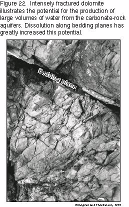
The carbonate rocks are highly fractured and are locally brecciated (fig. 22). Individual outcrops of the aquifers can exhibit three or more sets of joints, one or more high-angle faults, and one or more brecciated zones. For example, in the Nevada Test Site area near Las Vegas, Nev., the joints and most of the faults in the carbonate rocks are steeply inclined fractures. Brecciation commonly occurs along faults showing only a few feet of displacement and does not necessarily reflect movement of large magnitude. Joint density bears a strong relation to rock type; fine-grained carbonate rocks have the greatest joint density. Generally, the joints divide the rock into blocks that range from 1 inch to a few inches on a side. Medium-grained carbonate rocks are divided into blocks that range from a few inches to 1 foot on a side, whereas blocks of coarse-grained carbonate rocks commonly range from 6 inches to 2 feet on a side.
In outcrop, secondary openings are locally along bedding planes in the carbonate rocks, but no widespread connection of such openings is known. Some of the bedding-plane openings might have formed entirely by subaerial mechanical and chemical weathering, but some might have formed by partial dissolution of the rock. Dissolution, presumably in the subsurface, has created small, smooth, tabular openings along otherwise tightly closed bedding and joint planes (fig. 22).
Basin-Fill Aquifers
Before the most recent period of tectonic activity, which began
in middle Miocene time (about 17 million years before present),
the Basin and Range region was characterized by moderate relief,
and streams in the region did not have enough power to transport
large volumes of sediments. As the mountains were uplifted, however,
stream gradients increased and the transporting power of the streams
greatly increased. Steep, narrow canyons and gulches were incised
into the sharp escarpments that bounded the mountain ranges and
enormous volumes of material were eroded from the mountains. In
some places, blocks of sandstone greater than 10 feet in diameter
were transported several miles from their outcrop areas onto flat
areas beyond the mouths of canyons. The sediments eroded, transported,
and deposited by the streams are the principal material of basin-fill
aquifers (fig. 23). Some of the older
basin-fill deposits (Miocene and Pliocene age) are consolidated;
however, the basin fill consists mostly of unconsolidated deposits
of Pliocene through Holocene age.
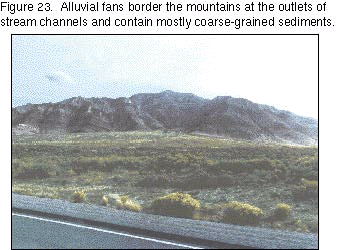
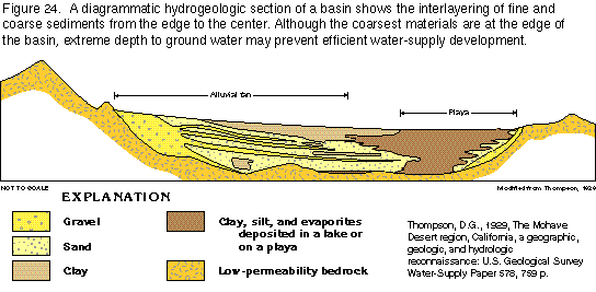
The most permeable basin-fill deposits are present in the depressions created by late Tertiary to Quaternary block faulting and can be classified by origin as alluvial-fan, lake-bed, or fluvial deposits. At the time of major deposition, the climate was more humid than the modern climate. Lakes were in most of the closed basins and some basins were connected by streams. In general, the coarsest materials (gravel and boulders) were deposited near the mountains, and the finer materials (sand and clay) were deposited in the central parts of the basins or in the lakes. Occasionally, torrential storms produced heavy runoff that carried coarse material farther from the mountains and resulted in the interfingering of fine and coarse material. The distribution of sediment size is directly associated with distance from the mountains. Three geomorphic landforms can be distinguished on the basis of the gradient of the land surface. Alluvial fans border the mountains and have the steepest surface slopes and the coarsest sediments (fig. 24). Basinward, individual alluvial fans flatten, coalesce, and form alluvial slopes of moderate gradient. A playa, or dry lake bed with a flat surface, is present in the lowest part of the basin, usually at or near the center of the basin (fig. 19), and most of the sediment deposited on the playa is fine grained.
The most important hydrologic features of the basins are the alluvial fans. The basin fill receives most of its recharge through the coarse sediments deposited in the fans. These highly permeable deposits allow rapid infiltration of water as streams exit the valleys that are cut into the almost impermeable rock of the surrounding mountains and flow out onto the surface of the fans. The coarse and fine sediments within the alluvial fans are complexly interbedded and interfingering (fig. 24) because the position of the distributary streams that transported the sediments continually shifted across the top of the fan.
Material deposited in perennial lakes or in playas consists principally of clay and silt with minor amounts of sand and is present in all of the basins. In most places, these sediments include some salts deposited by evaporation. The clay and salt deposits merge laterally into coarse-grained deposits of the alluvial slopes. Minor well-sorted beach sand and gravel locally are in the subsurface near the shores of once perennial lakes.
Fluvial deposits of Holocene age in the basins consist primarily of alluvial sand and gravel and are present along the courses of modern or ancestral streams that generally parallel the long axes of the basins. Quaternary fluvial deposits in stream channels usually exhibit a greater degree of sorting than the alluvial-fan deposits.
GROUND-WATER FLOW SYSTEMS
The ground-water flow systems of the Basin and Range area are in individual basins or in two or more hydraulically connected basins through which ground water flows to a terminal discharge point or sink. Except for relatively small areas that drain to the Colorado River, water is not discharged to major surface-water bodies but is lost solely through evapotranspiration. Each basin has essentially the same characteristics-the impermeable rocks of the mountain ranges serve as boundaries to the flow system, and the majority of the ground water flows through basin-fill deposits. In the area where carbonate rocks underlie the basins, substantial quantities of water can flow between basins through the carbonate rocks and into the basin-fill deposits, but this water also is ultimately discharged by evapotranspiration. Most recharge to the basin-fill deposits originates in the mountains as snowmelt, and, where the mountain streams emerge from bedrock channels, the water infiltrates into the alluvial fans and replenishes the basin-fill aquifer. Intense thunderstorms may provide some direct recharge to the basin-fill deposits, but, in most cases, any rainfall that infiltrates the soil is either immediately evaporated or taken up as soil moisture; little water percolates downward through the unsaturated zone to reach the water table in the valleys. In mountain areas underlain by permeable carbonate rocks, most of the recharge may enter the carbonate rocks and little water remains to supply runoff.
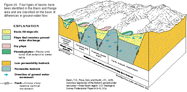
Because regional aquifers are not continuous within the Basin and Range area, the individual basins, which are encircled by topographic drainage divides, have been classified as one of four types based on similar recharge-discharge relations (fig. 25 and table 1). The simplest type is the "undrained, closed basin," a single valley in which the underlying and surrounding bedrock is practically impermeable and does not allow interbasin flow, and all recharge is discharged at a sink represented by a playa near the center of the basin. Basins underlain by permeable bedrock commonly are hydraulically connected as multiple valley systems. The "partly drained, closed basin" is underlain or surrounded by bedrock that is moderately permeable and allows some ground water to flow out of the basin. In this type of basin, some water is evaporated or transpired at the upgradient side of a playa, but most of the water continues to flow past the downgradient side of the playa and leaves the basin. The "drained, closed basin" has a deep water table that prevents evapotranspiration. The bedrock is sufficiently permeable to allow all recharge to flow through it and out of the basin. The "terminal sink basin" is underlain or surrounded by bedrock that is sufficiently permeable to conduct flow into the basin, and the playa in the basin is the discharge point for recharge from several connected basins.
In some places, an existing or ancestral stream course connects several basins that are not closed. The individual basins connected by such streams can also be classified as partly drained, drained, or terminal sink.
Examples of the individual type basins follow, except for the drained closed basin. With the exception that the water table in the drained closed basin is far below the playa, the partly drained and drained closed basins are sufficiently similar that discussion of each type is not warranted.
Single, Undrained, Closed Basin
Antelope Valley, Calif., which is an example of a single, undrained,
closed basin, is a large topographic and ground-water basin in
the western part of the Mojave Desert in southern California.
Antelope Valley occupies part of a structural depression that
has been downfaulted between the Garlock and the CottonwoodRosamond
Faults and the San Andreas Fault Zone (fig.
26). Consolidated rocks that yield virtually no water underlie
the basin and crop out in the highlands that surround the basin.
They consist of igneous and metamorphic rocks of pre-Tertiary
age that are overlain by indurated continental rocks of Tertiary
age interbedded with lava flows.
Alluvium and interbedded lacustrine deposits of Quaternary age are the important aquifers within the closed basin and have accumulated to a thickness of as much as 1,600 feet (fig. 27). The alluvium is unconsolidated to moderately consolidated, poorly sorted gravel, sand, silt, and clay. Older units of the alluvium are more compact and consolidated, somewhat coarser grained, more weathered, and more poorly sorted than the younger units. The rate at which water moves through the alluvium (the hydraulic conductivity of the alluvium) decreases with increasing depth.
During the depositional history of Antelope Valley, a large intermittent lake occupied the central part of the basin and was the site of accumulation of fine-grained material. The rates of deposition varied with the rates of precipitation. During periods of relatively heavy precipitation, massive beds of blue clay formed in a deep perennial lake. During periods of light precipitation, thin beds of clay and evaporative salt deposits formed in playas or in shallow intermittent lakes. Individual beds of the massive blue clay can be as much as 100 feet thick and are interbedded with lenses of coarser material as much as 20 feet thick. The clay yields virtually no water to wells, but the interbedded coarser material can yield considerable volumes of water.
During deposition of the lacustrine deposits, alluvial material that was supplied from the San Gabriel Mountains encroached upon the lake and forced it northward, which resulted in a northward transgression of alluvium over lacustrine deposits. The subsurface extent of the buried lacustrine deposits is shown in figure 27. The lacustrine deposits underlie the central part of the basin and have a somewhat lenticular shape. The thickest section is near the center of the basin, and the deposits thin towards the edges of the basin. Near Little Buttes and near the east and north edges of Rogers Lake, the deposits pinch out (fig. 27, section BB'). Along the northern and southern boundaries of the basin, the lacustrine deposits are about 100 and 400 feet thick, respectively, where they abut buried escarpments of consolidated rocks (fig. 27, section AA'). Near the southern limit of the basin, southeast of Lancaster, the lacustrine deposits are buried beneath about 800 feet of alluvium, but near Rosamond Lake, they are exposed at the surface (fig. 27, section AA').
Two aquifers, which are separated by the lacustrine deposits, are in the alluvial material (fig. 27). The upper aquifer is the principal and most used aquifer and contains water under unconfined, or water table, conditions. Where the lower, or deep, aquifer underlies lacustrine deposits, it contains water under confined, or artesian, conditions; elsewhere, unconfined conditions prevail.
Transmissivity values for the principal aquifer (fig. 28) are estimated to range from less than 1,000 to more than 10,000 feet squared per day. The transmissivity of an aquifer is a measure of how rapidly water will pass through the aquifer; the greater the transmissivity, the faster the movement of the water and the more water the aquifer will yield to wells. Where the principal aquifer is thin, either near its boundaries or on the uplifted parts of fault blocks, its transmissivity is low; where the aquifer is thick or consists of coarse-grained deposits, or both, the transmissivity is high.
The estimated transmissivity of the deep aquifer (fig. 29) ranges from about 2,000 to 10,000 feet squared per day and is greatest where the aquifer is thick. The transmissivity of the deep aquifer varies less than that of the principal aquifer (compare figs. 28 and 29) probably because the thickness of the deep aquifer is more uniform than that of the principal aquifer.
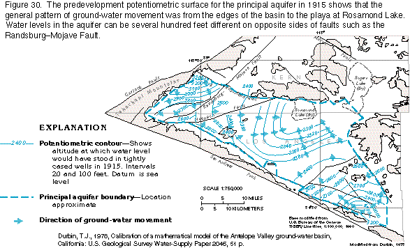
Ground water in the Antelope Valley Basin moves from the base of the San Gabriel and the Tehachapi Mountains toward Rosamond Lake in the north-central part of the basin (fig. 30). As ground water moves eastward across the western limit of the lacustrine deposits, part of the water moves above the lacustrine deposits to recharge the principal aquifer and part moves below the lacustrine deposits to recharge the deep aquifer. Major faults that cut the alluvial deposits in Antelope Valley, especially the RandsburgMojave Fault (fig. 30), act as partial barriers to the movement of ground water. Water-level differences of more than 300 feet in the same aquifer are present across the RandsburgMojave Fault. Along several other faults, the water table is several tens of feet higher on the upgradient side of the fault than on the downgradient side.
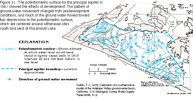
An estimate of the shape of the predevelopment potentiometric surface of the principal aquifer in 1915 (fig. 30) shows that before extensive pumping began, the water table was near the land surface in the central part of the basin; ground water moved northward and northeastward, and discharged by evapotranspiration at Rosamond Lake, which was dry. Withdrawal of ground water from the principal aquifer and the subsequent lowering of the water table reduced this natural discharge. By 1961, the direction of ground-water movement in the principal aquifer had been reversed from northeastward to southward and southeastward, toward the center of the basin in the area immediately southeast of Rosamond Lake (fig. 31). The main change in the potentiometric surface was the development of areas of low water levels near the withdrawal centers and the resultant reversal in the direction of ground-water flow near these areas.
Ground water leaks through the lacustrine deposits between the principal and deep aquifers even though the lacustrine deposits do not readily yield water to wells. Based on the hydraulic heads for the two aquifers, water leaks downward along the western and southern periphery of the lacustrine deposits. In the north-central part of the area underlain by the lacustrine deposits, water leaks upward. Because of the large withdrawals from the principal aquifer, the area of upward leakage has expanded toward the areas of concentrated withdrawal (fig. 31).
The aquifers in Antelope Valley are recharged primarily by infiltration of streamflow that originates in the mountainous areas that surround the valley. The average annual precipitation on the valley floor is less than 10 inches, and runoff is minor. For the most part, streamflow that enters the valley is intermittent. During storm periods, streamflow enters the valley along its perimeter and moves across the surface of the alluvial fans toward the playas at Rosamond and Rogers Lakes. As the streams flow across the alluvial fans, all the streamflow generally infiltrates the permeable surficial deposits on the fans. Because of the desert conditions, much of the infiltrating water is quickly lost by evaporation or as transpiration by riparian vegetation. The remainder of the water infiltrates downward through the alluvial deposits until it reaches the water table.
The drainage area tributary to Antelope Valley is about 385 square miles. Runoff from about 20 percent of this area is measured and the collective average annual discharge at the measured points is about 24,300 acre-feet. By calculating the measured runoff per unit area and extrapolating this value to unmeasured areas, the total runoff that enters the valley was estimated to be 40,700 acre-feet.
Evapotranspiration is the major natural discharge of ground water in Antelope Valley. Ground water generally discharges by evaporation from the water table where the water table is within 10 feet of the land surface, and, where vegetation is present, transpiration may also occur. Evaporation from an open body of water in Antelope Valley was measured at about 114 inches per year, which is an upper limit for evaporation of ground water. Because evapotranspiration from the ground-water system is complex, exact values cannot be determined.
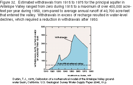
The use of ground water for agriculture in Antelope Valley began about 1880, when wells were drilled near the center of the valley and yielded flowing water in quantities sufficient for irrigation. In 1891, more than 100 wells were in use, but most had stopped flowing. About 1915, intense use of ground water began when a large number of wells were drilled and equipped with pumps. An estimate of annual withdrawal rates from 1915 to 1975 is shown in figure 32. The maximum rate of withdrawal of about 400,000 acre-feet per year is about 10 times the estimated annual recharge to the basin. Water removed from storage in the aquifers was a major part of the ground-water withdrawals, and severe water-level declines resulted. By about 1950, studies showed that ground-water withdrawals in the valley were greatly in excess of natural recharge and withdrawals were curtailed.
The geographic distribution of withdrawals was generally unchanged between 1915 and 1960. After 1960, withdrawals were redistributed by abandoning some wells and adding some new wells. With the new distribution, the center of withdrawal was split into two areas; one was approximately 5 miles southeast, and the other approximately 10 miles southwest of Rosamond Lake (fig. 31).
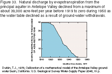
Withdrawals from the deep, or confined, aquifer in Antelope Valley have caused an increase in leakage to the deep aquifer from the principal aquifer along the western and southern peripheries of the lacustrine deposits. This leakage has locally lowered the water table in the principal aquifer and has resulted in the reduction of natural discharge from the aquifer. Most of the declines in the principal aquifer, however, are the consequence of withdrawals from that aquifer. Field data are not available to show the effects of water-level declines on the amount of natural discharge, but the results of a digital flow model indicate that most of the natural evapotranspiration from the center of the valley might have ceased by 1950 (fig. 33) because water levels in the principal aquifer were too deep to allow evaporation or transpiration.
Ground water in closed basins is commonly highly mineralized because discharge by evapotranspiration increases the concentrations of minerals in the water. Some of the minerals might precipitate at or near the center of the basin. However, dissolved-solids concentrations in ground water remained practically the same or decreased slightly in Antelope Valley between 1908 and 1955 (fig. 34); this was probably caused by the reduced evapotranspiration that resulted from declining water levels in the principal aquifer.
Partly Drained, Closed Basin
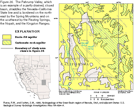
The Pahrump Valley, an example of a partly drained, closed basin,
covers about 1,050 square miles in Nye and Clark Counties, Nev.,
and Inyo and San Bernardino Counties, Calif. (fig.
35). The Spring Mountains, which form the northeastern border
of the basin, are the dominant topographic feature and are the
source of all the water that enters the basin. The southwestern
side of the Spring Mountains is characterized by large alluvial
fans that head high in the canyons that lead from Charleston Peak.
The most prominent of these fans have coalesced to form the Pahrump
and the Manse Fans.
The Pahrump Valley is part of an intervalley ground-water flow system. The regional movement of ground water is generally southwestward to low areas adjacent to the Amargosa River. The major areas of ground-water discharge downgradient from the Pahrump Valley are between the towns of Tecopa and Shoshone, Calif., which are 10 to 15 miles southwest of the topographic boundary of the Pahrump Valley (fig. 35).
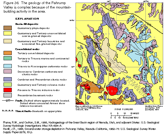
Mountain-building activity in southern Nevada has affected the ground-water flow system in the Pahrump Valley. Several large thrust faults are exposed in the Spring Mountains and at the northern end of the Nopah Range (fig. 36). In some places, low-permeability clastic rocks have been displaced by the faulting so that they are above or adjacent to water-yielding carbonate rocks and thus restrict ground-water movement in the carbonate rocks. Under some conditions, permeable zones of broken rock along the fault planes might be conduits for ground water. Springs and stands of mesquite along the northwestern sides of these faults, however, suggest that the faults are barriers to ground-water flow and that the ground water moves upward along the barriers until it emerges at the land surface. Folding, associated with the faults, produced joints and fractures in some of the rocks, resulting in significant secondary permeability.
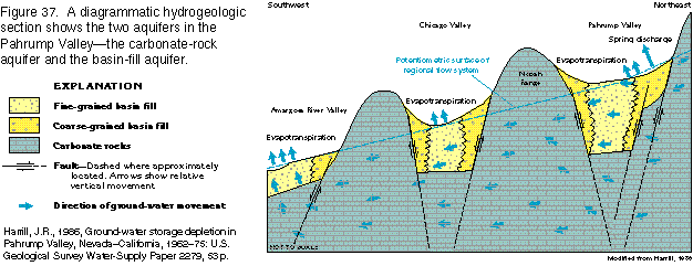
Two distinct aquifers are in the Pahrump Valley-the carbonate-rock aquifer, formed of carbonate rocks that bound and underlie the valley, and the basin-fill aquifer, which consists of unconsolidated deposits that have accumulated in the structural depression of the valley (fig. 37). The carbonate rocks transmit water readily and carry significant ground-water flow from the Pahrump Valley into the adjacent Chicago and Amargosa River Valleys to the southwest. The carbonate-rock aquifer is virtually undeveloped and significant future development is improbable because it is necessary to drill wells to great depths in order to obtain adequate yields. The basin-fill aquifer is, therefore, the source of virtually all withdrawals.
The carbonate-rock aquifer consists primarily of carbonate rocks of Triassic to Cambrian age that crop out in the Spring Mountains (fig. 36) and underlie the basin fill of the Pahrump Valley (fig. 37). The aquifer extends westward and southwestward through the Nopah and the Resting Springs Ranges into the California and the Chicago Valleys (figs. 35 and 37). Because no well in the Pahrump Valley penetrates the carbonate-rock aquifer, the hydraulic properties of the aquifer are inferred from information obtained in other areas. Hydraulic continuity in the carbonate-rock aquifer is the result of an extensive network of interconnected fractures and, to a small degree, of localized solution openings. Estimates of transmissivity from nearby localities outside the valley ranged from 130 to 120,000 feet squared per day as determined from aquifer-test data from 10 wells. The greater the transmissivity, the more water the aquifer will yield. The wide range in estimated transmissivity might not be randomly distributed and might reflect variations that result from faulting as well as the number and size of solution openings.
The basin-fill aquifer consists of unconsolidated alluvial and lacustrine deposits that partly fill the structural depression of the Pahrump Valley. Coarse-grained materials have been deposited near the sides of the valley, and fine-grained lacustrine materials are in the central parts of the valley (fig. 37). The approximate areal extent of the basin-fill aquifer is 650 square miles, or about two-thirds of the total area of the Pahrump Valley. To the northeast, northwest, and southwest, the aquifer is bounded by consolidated rocks of the Spring Mountains and the Resting Springs, the Nopah, and the Kingston Ranges. To the southeast, the aquifer is bounded by a ground-water divide beneath a topographic high that separates the Pahrump and the Mesquite Valleys. Because no ground water flows across this divide, the ground-water flow systems of the two valleys are separate.
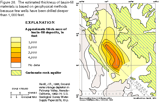
Wells drilled into the basin-fill aquifer range from several tens of feet to more than 1,000 feet deep. With the exception of one or two wells near the margin of the aquifer, the wells do not fully penetrate the basin fill. Therefore, the thickness of the basin-fill aquifer was estimated from geophysical meas-urements. The maximum thickness of the aquifer is about 4,800 feet in the central part of the valley (fig. 38). In general, the thickest accumulations of basin fill parallel the axis of the valley. The area of maximum thickness is offset slightly toward the south end of the valley, suggesting some faulting or folding in that area.
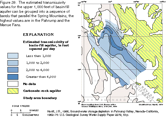
Estimates of the transmissivity of the basin-fill aquifer (fig. 39) are representative only of the upper 1,000 feet of the aquifer, which is the part penetrated by most wells. Variations in transmissivity are related to the deposition of the coarser materials and the position of the water table. Transmissivity values increase from the edge of the Spring Mountains, where the saturated materials are thin, toward the center of the valley, where the land surface is flatter, the water table approaches the land surface, and the aquifer is thickest. The increase in saturated thickness within the zone of coarse materials provides the highest transmissivity values; values are greater than 4,000 feet squared per day in the Pahrump and the Manse Fans. Transmissivity values decrease in nearly parallel bands across the valley to less than 1,000 feet squared per day as the sediments become finer and the saturated thickness lessens near the mountains on the southwest side of the valley.
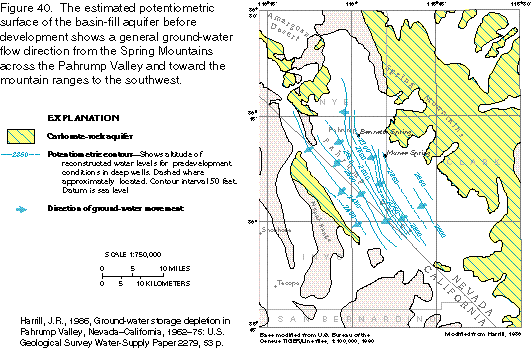
Virtually all the ground water in the Pahrump Valley is derived from precipitation. Most ground-water recharge occurs in the mountains, where percolating water moves through bedrock fractures to the zone of saturation, and on the upper slopes of the alluvial fans, where streamflow percolates through the unsaturated basin fill downward to the zone of saturation. The general slope of the ground-water surface in the Pahrump Valley before development (before 1913) is shown in figure 40. This map was constructed by using the earliest measurements available and shows the approximate configuration of the potentiometric surface of the basin-fill aquifer. Ground-water flow was generally from the principal recharge areas adjacent to the Spring Mountains, southwestward across the valley towards the Nopah Range. Water left the valley by evapotranspiration in the areas of shallow ground water and by subsurface outflow beneath the Nopah Range. The contours in figure 40 suggest that as ground water flowed southwest across the northwestern part of the Pahrump Valley, it moved into and through outcrops of carbonate rocks. The final discharge area for this water is not known with certainty. The 2,600-foot contour in figure 40 indicates that the hydraulic gradient in the northwestern part of the valley is toward the Ash Meadows discharge area in the Amargosa Desert north and west of the Pahrump Valley (fig. 35). However, the majority of the ground-water flow probably moved to a discharge area along the Amargosa River between the towns of Shoshone and Tecopa, which are southwest of the Pahrump Valley.
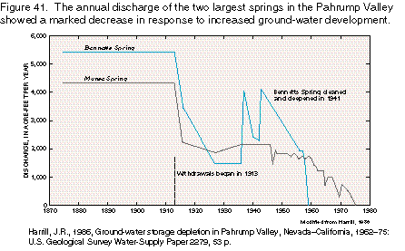
Ground water has been developed to support agriculture in the Pahrump Valley for many years. Two large springs, Bennetts and Manse Springs (fig. 35), provided water to early travelers and were soon developed as a source of supply for irrigation. In the late 1800's, Bennetts Spring reportedly discharged about 7.5 cubic feet per second (5,430 acre-feet per year), and Manse Spring, about 6 cubic feet per second (4,340 acre-feet per year); most of this water was diverted to agriculture. Spring flow decreased dramatically in 1913 when ground-water withdrawals began. Bennetts Spring eventually ceased to flow as the water table declined in response to withdrawals (fig. 41), and Manse Spring ceased to flow during the 1975 irrigation season.
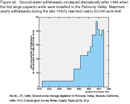
Ground water provides the water supply for virtually all uses in the Pahrump Valley. The first well was drilled in the valley in 1910 in an unsuccessful attempt to obtain a flowing well. However, in 1913, three flowing wells were successfully completed, and, by 1916, a total of 28 wells had been drilled, 15 of which were flowing. The number of new wells drilled and the annual withdrawals increased slowly until the mid-1940's when large-capacity wells were installed. From the mid-1940's through 1962, the annual discharge from wells increased from an estimated 4,000 to about 28,000 acre-feet (fig. 42).
From 1962 to 1975, population growth caused significant change in land use in the Pahrump Valley. Ground-water withdrawals increased rapidly between 1962 and 1968 (fig. 42) but decreased after 1968 as agricultural land was taken out of service and subdivided for residential use. Population of the valley increased from about 250 in 1962 to nearly 1,500 in 1975, and, when this land becomes fully developed, ground-water withdrawals could surpass those of 1968.
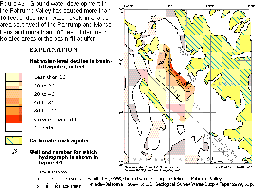
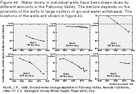
Between 1913 and 1975, nearly 700,000 acre-feet of ground-water withdrawals and about 550,000 acre-feet of spring flow had been discharged from the basin-fill aquifer in the Pahrump Valley. The two most apparent effects of the discharge were large ground-water level declines and a cessation in spring discharge. Water levels have been declining since the first wells were constructed in 1913. Variations in the annual rate of decline and the net change between predevelopment and 1975 water levels (fig. 43) among different locations depend on the distribution of withdrawal, the hydraulic properties of the basin fill, and the depth of the well being measured. Hydrographs of six wells are shown in figure 44 to illustrate the typical response of water levels to withdrawals in various parts of the valley. Generally, the greatest water-level declines (about 100 feet) were along the terminal parts of the Pahrump and the Manse Fans. Two wells located in the central part of the valley, away from the major concentration of withdrawal, showed substantially less water-level decline.
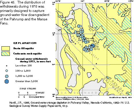
Withdrawals in the Pahrump Valley are distributed to capture ground-water flow downgradient of the Pahrump and Manse Fans and capture the discharge of Bennetts and Manse Springs in an effective manner (fig. 45). Consequently, spring discharge began to decrease shortly after withdrawals began and continued to decrease until 1975, when discharge of both springs ceased entirely during the irrigation season (fig. 41). Bennetts Spring ceased to flow in 1959; as of 1975, Manse Spring was dry during the summer irrigation season but recovered to discharge about 200 acre-feet during the winter months. The changes in spring discharge from 1875 through 1975 are shown in figure 41. The amount by which spring discharge has decreased is the amount of water captured by withdrawals. Thus, as of 1975, about 9,800 acre-feet per year of spring discharge had been captured by ground-water withdrawals.
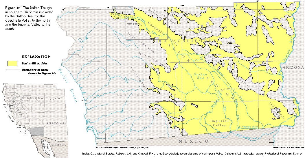
Terminal Sink Basin
The Salton Trough, which is a topographic and structural trough
that extends from southeastern California into Mexico, is an example
of a terminal sink basin. The Salton Trough is divided into two
parts by the Salton Sea-the Imperial Valley to the south and the
Coachella Valley to the north (fig. 46).
The Imperial Valley is the largest area of desert irrigation development
in the United States. Importation of water from the Colorado River
has transformed 500,000 acres of parched desert lands into one
of the most productive agricultural areas in the Nation. The Coachella
Valley has experienced dramatic declines in ground-water levels
due to public water supply demands for a growing population, stimulated
by the attraction of the Palm Springs area.
The desert climate of the Salton Trough is characterized by extreme aridity and high summer temperatures. Average annual precipitation is slightly less than 3 inches on the valley floor and about 40 inches at the crests of the San Jacinto Mountains. Maximum summer temperatures commonly exceed 104 degrees Fahrenheit, and winter minimums are seldom below 32 degrees Fahrenheit.
The Salton Trough is about 130 miles long and as much as 70 miles wide (fig. 46). The trough is a landward extension of the depression that is partially filled by the Gulf of California. The trough and gulf are separated by the broad fan-shaped subaerial delta of the Colorado River. Much of the land surface of the trough is below sea level and, before the delta was formed, the trough may have been part of the Gulf of California. The lowest part of the trough is occupied by the Salton Sea, whose surface is at an elevation of more than 200 feet below sea level. Most of the surface drainage is intermittent and is toward the Salton Sea in the central part of the valley. Surface water moves northwestward to the Salton Sea from the boundary between the United States and Mexico and southeastward from the San Gorgonio Pass.
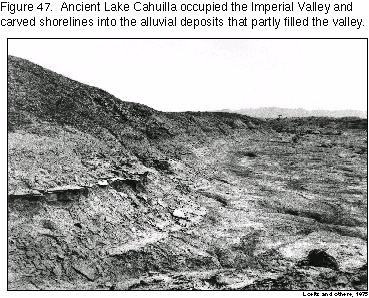
The Imperial Valley occupies the wider southern part of the Salton Trough. The valley ends at the Salton Sea to the northwest and continues southward into Mexico as the Mexicali Valley. The Chocolate Mountains border the valley to the northeast, and the Peninsular Range of Baja California and southern California borders it to the southwest. The floor of the valley slopes northwestward from about sea level at the international boundary to about 230 feet below sea level at the Salton Sea. The Salton Trough was once occupied by prehistoric Lake Cahuilla. In the eastern and western parts of the trough, several ancient lake shorelines (fig. 47) are at elevations of 42 to 50 feet above sea level.
The central part of the Imperial Valley is a large area of cultivated land entirely within the shorelines of prehistoric Lake Cahuilla. Most of the central Imperial Valley is a monotonous plain dissected by the Alamo and the New Rivers, which have incised trenches as much as 40 feet deep in soft, silty lacustrine deposits. Much of the entrenchment took place during 1905 through 1907 when virtually the entire Colorado River flowed uncontrolled in these channels and established the present-day Salton Sea. Before 1905, the center of the trough had been a playa. The lowest point of the surface of the trough is beneath the southern part of the Salton Sea and is about 275 feet below sea level.
The Coachella Valley in the northwestern part of the Salton Trough (fig. 46) extends from the east end of San Gorgonio Pass southeastward to the Salton Sea. It is bordered on the north and east by the Little San Bernardino Mountains and on the southwest by the San Jacinto and the Santa Rosa Mountains. The Whitewater River is the main drainage in the valley.
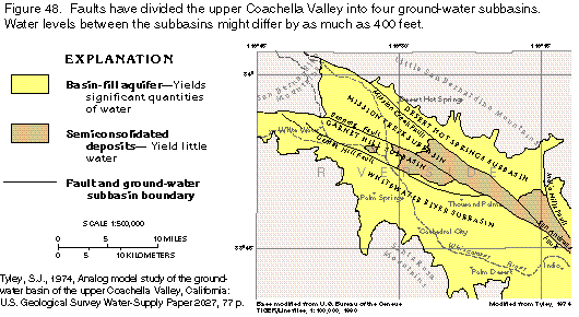
The Coachella Valley is affected by the San Andreas Fault system, which is a complex strike-slip fault system that includes the Mission Creek, the Banning, the Garnet Hill, and the Indio Hills Faults and associated folds (fig. 48). These faults act as barriers to ground-water flow and, combined with constrictions in the basin width and changes in permeability of the water-yielding units, have compartmentalized the Coachella Valley into the Desert Hot Springs, the Mission Creek, the Garnet Hill, and the Whitewater River ground-water subbasins (fig. 48). The Whitewater River subbasin is the largest of the four and contains the most productive aquifer.
The Gulf of California and its landward extension, the Salton Trough, are structural, as well as topographic, depressions beneath which consolidated rock is thousands to tens of thousands of feet lower than the consolidated rock in the bordering mountains. The Gulf of California and the Salton Trough formed during late Cenozoic time as a result of spreading of the ancient sea floor.
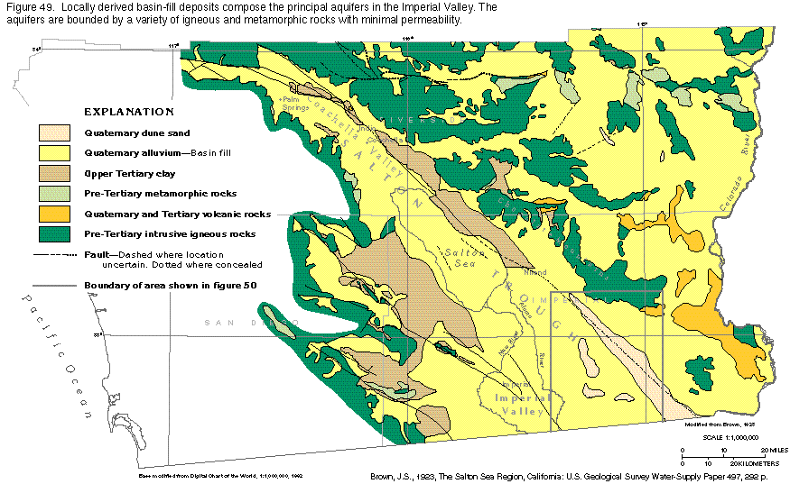
The aquifer system in the Salton Trough ranges from unconfined in the periphery of the trough to confined in the central part. It consists of basin-fill deposits of Quaternary and Tertiary age (fig. 49); these deposits of alluvium are underlain by rocks of pre-Tertiary age that are referred to as the "basement complex." Although the basin fill probably is more than 20,000 feet thick, the water-yielding parts of the basin fill extend only to depths of a few thousand feet. The water at greater depths is too saline for most uses, and the hydraulic connection between the shallow and deep deposits is poor.
Near the margins of the Imperial Valley, the basin-fill deposits were derived from the adjacent mountains and are mostly coarse sand and gravel. Deposits in the central part of the valley consist mostly of fine-grained sand, silt, and clay that were deposited by the Colorado River. In the eastern and western parts of the Imperial Valley, wells that are open to several hundred feet of the basin-fill deposits yield moderate to large volumes of water. Transmissivity values of 20,000 to 30,000 feet squared per day are characteristic of these deposits, and wells that yield 50 gallons per minute or more per foot of drawdown are attainable. In the central part of the Imperial Valley, transmissivity values of 150 to 1,500 feet squared per day were calculated from two aquifer tests of wells completed in the upper 500 feet of the fine-grained deposits.
Aquifer material in the Coachella Valley is mostly coarse-grained sediments, and the aquifer is generally unconfined. These deposits are more than 3,000 feet thick, are moderately to highly permeable, and yield large quantities of water to wells. Transmissivity is greatest in the central part of the valley from Palm Springs to the Salton Sea because of the great thickness of permeable deposits. Maximum transmissivity values of about 25,000 feet squared per day are similar to those reported from the Imperial Valley.
Unlike the other valleys discussed above, the most important source of ground-water recharge to the Imperial and the lower Coachella Valleys is the Colorado River, not runoff from the surrounding mountains. Minor sources of recharge are ground-water inflow from adjacent areas, infiltration of precipitation that falls on the valley floor, and local runoff from the mountains that border the area.
The Colorado River has been a source of recharge to the aquifer system of the Imperial Valley since the river delta built to a height sufficient to separate the Gulf of California from the Salton Trough. As the delta was built, natural levees beside the river channel kept the Colorado River above the land surface altitude in much of the valley. Under natural conditions, water from the river seeped downward through the river bed and then moved laterally to recharge the aquifer in the Imperial Valley. The water also moved into the Imperial Valley from the Mexicali Valley to the south and through a section of alluvium northeast of the Cargo Muchacho Mountains.
Since 1901, recharge to the shallow part of the aquifer system under natural conditions has been augmented by percolation of water imported from the Colorado River beginning in 1901. Originally, water was diverted about 10 miles southwest of Yuma, Ariz., at the confluence of the Colorado River and Mexico's Alamo Canal, and was delivered to the Imperial Valley through the Alamo and the New Rivers (fig. 46). The completion of the All American Canal (fig. 46), which permitted the diversion of Coloraro River water to the Imperial Valley through a canal located entirely in the United States rather than along a route that passed through the Mexicali Valley, greatly increased the opportunity for ground-water recharge. The All American Canal became the sole means for diverting Colorado River water to the Imperial Valley in February 1942. Six years later, the Coachella Canal was completed and thereafter supplied water to the lower part of Coachella Valley.
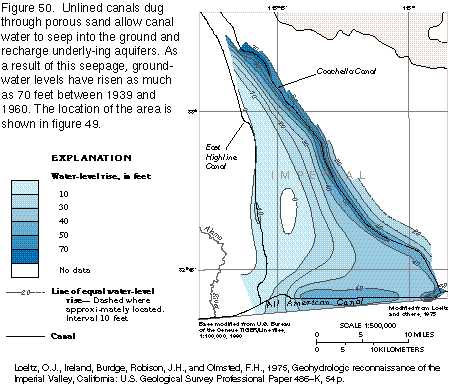
The canals, which are as much as 200 feet wide, are major sources of recharge because they are unlined, flow across many miles of sandy terrain (especially in the eastern part of the Imperial Valley), and are much higher in altitude than the general ground-water levels along their course. The leakage from the canals almost immediately caused ground-water mounds to form beneath the canals, and, over time, ground-water levels rose to the water level in the canals. The leakage also spread horizontally, thereby causing water levels to rise over large areas. Water levels eventually rose to the point that much of the leakage, especially from the All American Canal, was discharged to drains and areas of natural discharge, rather than continuing to add to the quantity of ground water stored in the aquifer system.
The rise in water levels that resulted from leakage from the easternmost canals between 1939 (before the canals were completed) and 1960 is shown in figure 50. The water-level rise along the All American Canal was generally more than 40 feet, and the rise along the Coachella Canal was about 40 feet near the junction of the canal with the Colorado River and gradually increased northward to more than 70 feet. Throughout most of the length of the East Highline Canal, which began operating in 1942, the original water table was shallow, and the water-level rise was small.
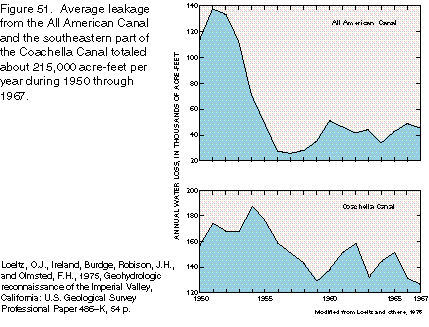
Water losses along selected reaches of the All American and the Coachella Canals are shown in figure 51. The annual flows are generally 3,000,000 to 4,000,000 acre-feet in the reach of the All American Canal and are about 500,000 acre-feet in the reach of the Coachella Canal. From 1950 through 1967, the average leakage from the two reaches was about 215,000 acre-feet per year.
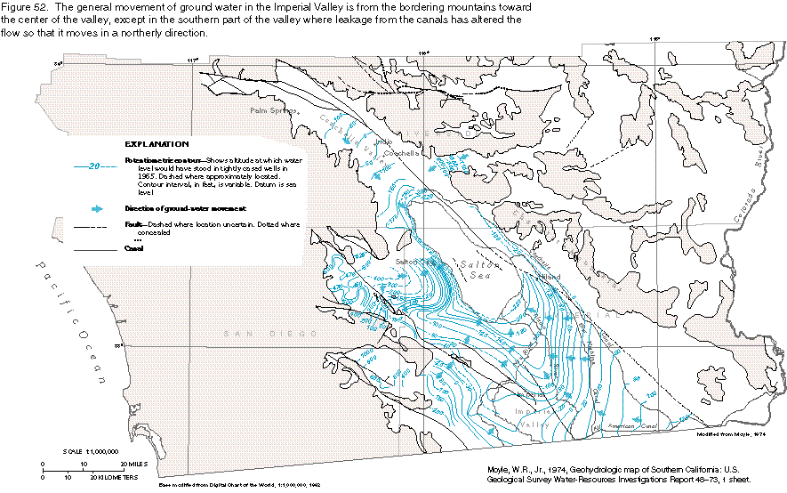
The general direction of ground-water movement in the basin-fill aquifer of the Imperial Valley and the lower part of the Coachella Valley is shown by the arrows superimposed on the water-level contour lines in figure 52. The contours were based on water levels in 1965 in wells completed in the main water-yielding zones.
The broad ground-water mound in the southeastern part of the valley is the result of leakage from the All American and the Coachella Canals. Between the canals, the direction of ground-water movement is principally westward, but south of the All American Canal, the movement is toward the Mexican border. Away from the canals, ground water moves generally toward the axis of the valley and then northwestward to the Salton Sea. The principal area of discharge is the central, cultivated part of the valley. Substantial amounts of ground water are discharged to the Alamo River, as indicated by the closely spaced contour lines on the eastern side of the river and the change in direction of the contours which indicates that the ground water flows primarily northward. Ground water also discharges to the New River, but the configuration of the contour lines, which show a relatively wider spacing and moderate upstream displacement, indicates that considerably less ground water moves to the New River than to the Alamo River.
For ground water that moves from the adjacent mountains toward the center of the valley, a wide range of contour spacing can be seen in figure 52 that indicates changes in the hydrogeologic conditions within the aquifer. Some of the seemingly abrupt changes in contour spacing are caused by faults that are barriers to ground-water flow. The closely spaced contours west of the Coachella Canal, near Niland, and west of the Salton Sea, near Salton City, result from ground-water flow through deposits with low permeability.
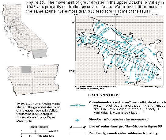
Ground-water movement in and through the basin-fill aquifer of the upper Coachella Valley is affected by the San Andreas Fault System. Faults that are part of this system, as well as constrictions in basin width and changes in permeability of the water-yielding units, have compartmentalized the valley into four ground-water subbasins (fig. 48).
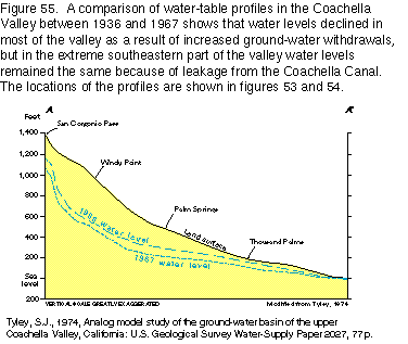
The general direction of ground-water movement in the upper Coachella Valley was determined from water-level contour maps of the basin for 1936 and 1967 (figs. 53 and 54). Water-level contours during the autumn of 1936 are shown in figure 53. The water-level profile for 1936 (fig. 55) shows the slope of the ground-water surface to be very steep in places and to exceed 50 feet per mile from the San Gorgonio Pass to Windy Point. This steep gradient decreased to less than 10 feet per mile just south of Palm Springs because of the increased width of the basin. From the Thousand Palms area southward, the gradient was about 20 feet per mile.
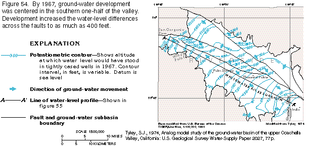
A water-level profile for 1967 (fig. 55) shows that while water levels declined in most places in the valley, the steep water-level gradient from the San Gorgonio Pass to Windy Point remained the same as in 1936. However, the water-level gradient at the south boundary decreased to about 10 to 15 feet per mile from the 1936 gradient of 20 feet per mile. The lowered water-level altitudes resulted from increased withdrawals within the Whitewater River subbasin. Water levels for 1967 were about the same as those for 1936 in the extreme southern part of the upper valley as a result of leakage from the Coachella Canal.
The general direction of ground-water flow in 1967 is shown in figure 54 by arrows that represent flow lines, which are the shortest possible paths between adjacent water-level contours. Ground-water movement in the Whitewater River subbasin was primarily parallel to the axis of the valley from Windy Point to Indio. The flow lines near the faults that mark the borders of the subbasins indicate that ground water flowed across the faults; exactly how much is unknown.
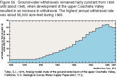
Ground-water development in the Salton Trough has been primarily in the Coachella Valley. The growth of agriculture and, since the early 1950's, of tourism has drawn heavily on the ground-water resources of the upper Coachella Valley. Ground-water levels have declined as annual withdrawals increased more than tenfold during 1936 to 1967 (fig. 56). In the lower Coachella Valley, concern over the diminishing ground-water supply as a result of agricultural development prompted the construction of the Coachella Canal. Water delivery began in 1949 when large quantities of Colorado River water were brought to the area between Indio and the Salton Sea. However, the upper Coachella Valley received only small quantities of the canal water and, consequently, water levels continued to decline as ground-water use increased in that area.
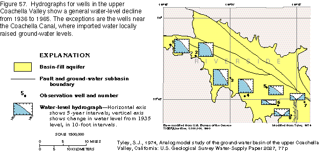
Water levels began to decline before 1945 (fig. 57) in the southernmost part of the upper Coachella Valley but did not change significantly in the remainder of the upper valley until about 1945 when major withdrawals began (fig. 56). Water levels continued to decline throughout most of the upper valley through 1965 with the exception of an area near the southern boundary where water levels had ceased to decline and began rising. The rise is documented by observation wells 7 and 8 in 1949 and 1954, respectively (fig. 57). The water-level rise in these two wells can be attributed to water from the Coachella Canal leaking downward to the aquifer. The effect of leakage appeared to be moving up the valley in 1955, as indicated by the hydrograph of well 6 (fig. 57), in which water levels ceased to decline, indicating recharge to the aquifer by leakage.
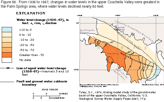
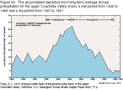
From 1936 to 1967, water-level changes in the upper Coachella Valley (fig. 58) were most prominent in the White-water River subbasin. The Palm Springs area in that subbasin showed the largest water-level decline (nearly 80 feet) because of a concentration of withdrawals in an area with a relatively low aquifer storage capacity located near where the aquifer abuts the nearly impermeable bedrock of the San Jacinto Mountains. Decreases in water levels were probably amplified between 1946 and 1967 because of a prolonged drought in the upper Coachella Valley, as in most of southern California, during those years. A representative plot of the departure from average precipitation in the San Jacinto, the Santa Rosa, and the San Bernardino Mountains (fig. 59) indicates that during the dry period from 1947 through 1964 only four years were wet-1952, 1954, 1957, and 1958. This extended dry period greatly reduced the natural inflow available to the valley. The other three ground-water subbasins showed very little water-level decline because withdrawals in those subbasins were small. A well field for the town of Desert Hot Springs on the east side of the Mission Creek Fault showed some decline because the storage capacity of the aquifer in that area is limited by the juxtaposition of the aquifer with a relatively impermeable fault and the nearly impermeable bedrock of the Little San Bernardino Mountains.
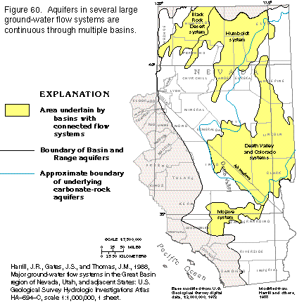
Connected Basin Flow Systems
Although most flow systems are confined to one or two basins in
the Basin and Range area, several basins are linked together in
an extended ground-water flow system in places (fig.
60). In the majority of the basins, flow passes through the
basin-fill sediments that cover the valley floors, as in the Humbolt
system. However, where carbonate rocks underlie the basins, data
indicate that some basins are hydrologically linked by the carbonate
rocks and that large quantities of ground water flow through them
and discharge through the overlying basin-fill sediments to large
springs. Because few wells are drilled into the carbonate rocks,
data are scarce and several assumptions have been made to account
for flow in these rocks. One assumption is that the carbonate
rocks and the basin-fill deposits form a single hydrologic unit.
At locations where wells have been drilled in both rock types,
the water levels in each aquifer have been similar. Another piece
of evidence that the two rock types act as one hydrologic unit
comes from the Ash Meadows area in southern Nevada. Irrigation
wells in that area that withdrew water from the basin-fill deposits
drew down water levels in the carbonate-rock aquifers more than
1 foot from 1969 to 1972.
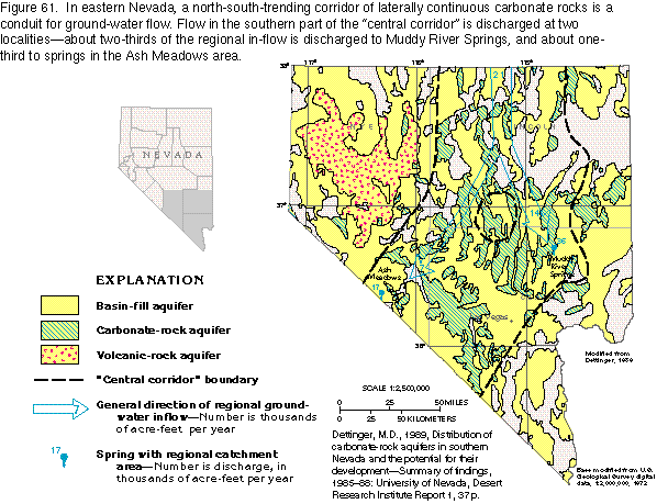
Thick sequences of carbonate rocks underlie most of the alluvial basins within the Basin and Range area in eastern Nevada and southeastern California (fig. 60); these rocks also extend into western Utah, northwestern Arizona, and southeastern Idaho. The carbonate rocks have been faulted, deformed, and eroded through geologic time; original thicknesses of up to 40,000 feet have been reduced by one-half or more. Consequently, most of these rocks are in isolated blocks that form individual aquifers with areal dimensions of only a few square miles. In Nevada, however, the carbonate rocks form a north-south section of aquifer, or "central corridor" (fig. 61), that is generally laterally continuous for more than 250 miles. The southern part of this corridor has been most studied, and two major flow systems have been identified. In both flow systems, ground water is recharged in east-central Nevada. In one system, ground water discharges at Ash Meadows and Death Valley and, in the other, primarily at Muddy River Springs (fig. 61).
These aquifer systems contain the closest approximation to regional flow systems in the Basin and Range area. Flow is transmitted along several valleys through the basin-fill and the carbonate-rock aquifers. However, an insufficient number of wells have been drilled in the carbonate rocks to permit a complete description of the flow system. Discharge from large springs in the alluvial basins is always in areas underlain by carbonate rocks.
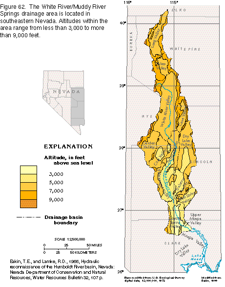
The most complete description of the carbonate-rock flow system is from the ancestral White River/Muddy River Springs area, which consists of 13 valleys in southeastern Nevada (fig. 62). During Pleistocene time, when the climate was more humid than at present, the White River drained six of these valleys and left a wash along its drainageway that is the lowest point anywhere along the drainage system. Five of the remaining seven valleys-Long, Jakes, Cave, Dry Lake, and Delamar-are topographically closed and have no streams that flow out of them. The Garden and the Coal Valleys form a topographically closed unit, in which streams in the Garden Valley drain into the Coal Valley. The entire 13-valley drainage area is bounded by mountains that range in altitude from about 7,000 feet in the south to more than 9,000 feet in the north (fig. 62).
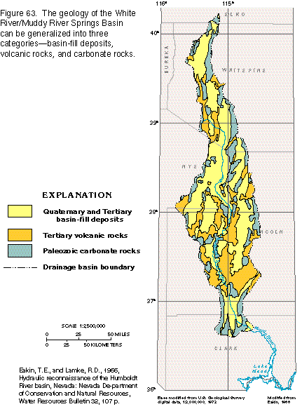
Consolidated rocks (fig. 63) of Paleozoic and Tertiary age form the boundaries of and underlie the basins, which are filled with unconsolidated deposits of Tertiary and Quaternary age. The principal water-yielding rocks of Paleozoic age are limestone and dolomite, which are bounded above and below by confining units of shale, sandstone, and quartzite. The rocks of Tertiary age are primarily tuff and welded tuff and generally transmit little water. However, in areas where the welded tuffs have been fractured, they can yield large quantities of water. The basin-fill deposits consist of coarse sand and gravel at the valley margins and grade to fine silt and clay near the center of the valleys. Valleys that were transversed by the White River during Pleistocene time contain channel deposits of sand and gravel in some places along the ancestral course of the river near the center of the valley.
Data used to determine the movement of ground water in the White River/Muddy River Springs area are from wells completed in basin-fill sediments and carbonate rocks, altitudes of spring orifices, and several mine shafts in carbonate rocks in the bordering mountains where water levels have been measured. The overall pattern of ground-water movement is shown in figure 64. Ground water moves southward from Long Valley to the White River Valley. The White River Wash defines the principal avenue of flow from the White River Valley to the upper Moapa Valley. Springs issue at several places along the White River Wash wherever the water table is at or near the land surface. Valleys that border the main drainageway of the White River-the Garden, the Coal, the Cave, the Dry Lake, and the Delamar Valleys-do not drain directly to the main drainage-way but rather to the south where the ground water leaves them.
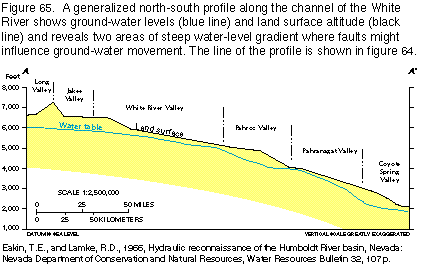
The topography of the drainage area controls the movement of ground water at a regional scale. The flow is in a southerly direction along the axis of the valley as shown by the decrease in water levels along the profile in figure 65, and is generally within tens of feet of the land surface in the center of the valleys. Three areas along this profile show that water levels may be hundreds of feet below land surface. The deep water table in Jakes Valley is caused by the high altitude of the valley floor. Some interpretations of the flow system have identified Jakes Valley as the northern limit of the White River/Muddy River Springs flow system. The deep water table in the Pahroc Valley and at the end of the Pahranagat Valley is thought to be along faults where the fractured rocks have been either cemented to form a barrier to flow or partly dissolved downgradient of the faults so that the permeability is greater and water is more quickly transmitted down-valley from the faults.
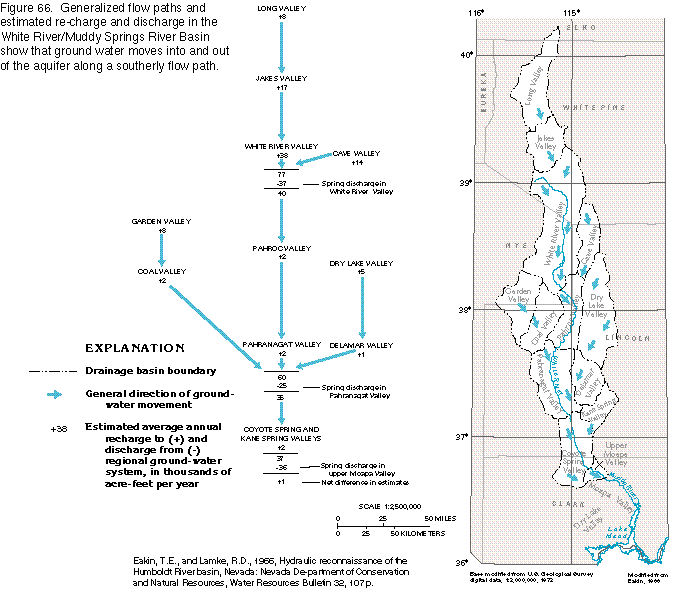
The intervalley ground-water flow pattern and the estimated water budget for the flow system are shown in figure 66. The estimated recharge to the valleys was based on the relation of altitude to annual precipitation (table 2). Because of the orographic effect of the mountains, the amount of precipitation increases as the altitude increases. Conversely, the amount of evapotranspiration decreases as altitude increases, as a consequence of lower temperatures at higher altitudes. Because of higher altitudes and lower temperatures in the northern one-half of the White River/Muddy River Springs drainage area, about 70 percent of the recharge is estimated to be in this one-half of the area. From measurements of spring discharge, about 62 percent of the discharge of the system has been determined to be in the Pahranagat and the upper Moapa Valleys in the southern one-half of the area. This distribution of recharge and discharge is additional evidence of interbasin flow. The substantial amount of ground water that moves from the northern to the southern one-half of the area must flow through the carbonate rocks.
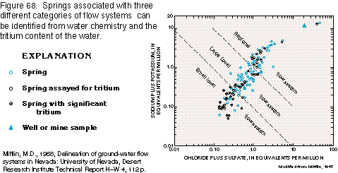
Interbasin flow within the carbonate rocks also is indicated by the water chemistry of perennial springs. Three classifications of the types of flow systems that feed the springs have been defined in the White River/Muddy River Springs area-regional, large local, and small local. Chemical analyses of water that discharges from perennial springs indicates that increased concentrations of dissolved constituents associated mostly with carbonate rocks are observed with regional systems characterized by long flow paths. Gypsum, anhydrite, halite, and scattered clay minerals in the carbonate rocks are dissolved more readily than carbonate minerals and they contribute sodium, potassium, chloride, and sulfate ions to ground water. Concentrations of these ions increase the longer the ground water is in circulation through the carbonate rocks. At each perennial spring that issues from the carbonate rocks, an indication of the relative distance the water has traveled can be determined by the concentration of these ions. Also, the temperature of the water discharged from a spring indicates the probable depth of ground-water circulation; higher temperatures are associated with the deep circulation of regional systems.
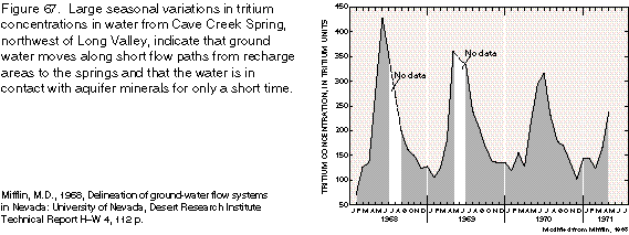
The concentration of tritium in water that issues from perennial springs has been used to determine places where ground water has had a short residence time in an aquifer. Before 1954, tritium, a hydrogen isotope, was scarce in the atmosphere. Beginning in 1954, detonation of thermonuclear bombs released large concentrations of tritium to the atmosphere in the northern hemisphere. Springs with water that contains tritium in concentrations of 200 units or more (fig. 67) are likely to be discharging a large percentage of ground water that has been in the aquifer for only a short time, perhaps only a few months.
A plot of concentrations of sodium and potassium ions against chloride and sulfate ions in water from the carbonate rocks in Nevada (fig. 68) shows the relation of these ions to the regional, large local, and small local flow systems. Regional flow systems are characterized by interbasin flow, long flow paths, and one or more local systems that feed the regional system. Springs connected to these systems have large perennial discharges and small seasonal ranges in discharge. Discharge waters contain relatively large concentrations of sodium, potassium, chloride, and sulfate ions but have small concentrations of tritium (fig. 68). Some springs discharge thermal water (greater than 80 degrees Fahrenheit).
Large local flow systems are characterized by predom-inantly interbasin flow and flow paths that are typically confined to one basin. Springs connected to these systems have moderate to large discharges and moderate seasonal ranges in discharge. Discharge waters contain moderate concentrations of sodium plus potassium and chloride plus sulfate (fig. 68) and no significant concentrations of tritium. Discharge waters have temperatures that typically range from 50 to 60 degrees Fahrenheit.
Small local flow systems are generally characterized by very short flow paths, usually no more than a few miles in length. Springs connected to these systems have highly variable annual ranges in discharge. Discharge waters have small concentrations of dissolved sodium plus potassium and chloride plus sulfate, large concentrations of tritium, and water temperatures that commonly approach average air temperatures.
The evidence of regional flow in the carbonate rocks can be used to evaluate the water-supply potential of the White River/Muddy River Springs Basin. Even if the carbonate-rock aquifer, as yet undeveloped, can supply additional water, the effect of such development upon the aquifer remains uncertain. The effect could be minimal if development can merely capture ground water currently being lost to evapotranspiration in the southern part of the White River/Muddy River Springs area. More information about the aquifer system, particularly data that pertains to aquifer boundaries, is needed in order to accurately determine the potential effects of development
FRESH GROUND-WATER WITHDRAWALS
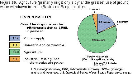
An estimated 1,760,000 acre-feet per year of freshwater was withdrawn
from aquifers in the Basin and Range area during 1985 (fig.
69). Withdrawals for irrigated agriculture accounted for almost
77 percent of the total. Public supply accounted for almost 18
percent of withdrawals. All other categories totaled less than
6 percent of fresh ground-water withdrawals.
GROUND-WATER QUALITY
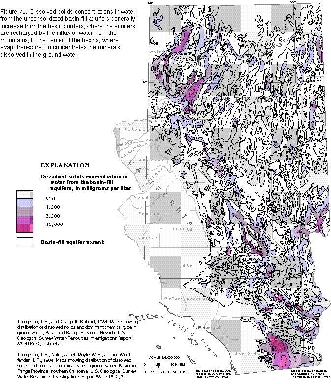
The quality of ground water in unconsolidated deposits in the
Basin and Range area varies from basin to basin; dissolved-solids
concentrations range from less than 500 milligrams per liter (freshwater)
to more than 10,000 milligrams per liter, as shown in figure
70. Generally, at the basin margins and on the slopes of alluvial
fans, the ground water is fresh. Locally, saline water is present
near some thermal springs associated with indurated sedimentary
rocks or igneous rocks and in areas where the basin-fill aquifers
include large amounts of soluble salts, such as in the upper and
middle parts of the Humbolt River Basin. In discharge, or sink,
areas such as the Carson and Salton Sinks and Death Valley, however,
the dissolved-solids concentration can exceed that of ocean water
(about 35,000 milligrams per liter). The ground water beneath
playas in small closed valleys may be brackish, but ordinarily
the dissolved-solids concentrations are not as large as those
in water from the major terminal sinks. Although highly mineralized
water is common beneath playas, a deeper freshwater flow system
might be present in some areas. For example, water from a well
1,200 feet deep on the northern margin of a playa in a valley
near Tonapah, Nev. (fig. 70), has a
dissolved-solids concentration of less than 350 milligrams per
liter. This concentration apparently reflects deep freshwater
circulation in the basin-fill aquifer. In valleys with subsurface
discharge into an extensive ground-water system, the water throughout
the basin-fill aquifer is generally fresh.