INTRODUCTION
This chapter of the Ground Water Atlas of the United States describes the aquifers in Arizona, Colorado, New Mexico, and Utah. These four States, which comprise Segment 2 of this Atlas, are located in the Southwestern United States and extend from the rolling grasslands of the Great Plains on the east across the Rocky Mountains and Continental Divide to the desert basins of the Southwest. The 425,000-square-mile area ranges in altitude from about 14,400 feet above sea level in the Rocky Mountains of Colorado to about 100 feet near the lower Colorado River in southwestern Arizona. All the ground water in Segment 2 ultimately is derived from infiltration of precipitation, which varies considerably with the altitude and topography of the area.
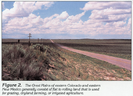
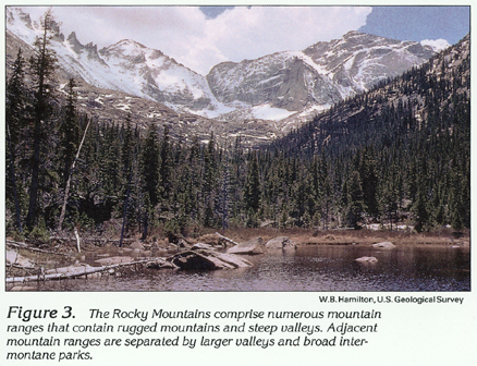
The Great Plains Physiographic Province of the Central United States extends into eastern Colorado and New Mexico (fig. 1), where flat to rolling prairie (fig. 2) with scattered hills and bluffs gradually rises westward to 5,000 to 7,000 feet above sea level and abruptly gives way to the frontal ranges of the Rocky Mountains in the Southern Rocky Mountain and Basin and Range Physiographic Provinces. West of the frontal ranges in Colorado and northern New Mexico are additional and higher mountain ranges generally oriented north-south but with many spurs and extensions oriented in other directions. The many ranges of the Rocky Mountains are separated by valleys and high mountain parks (fig. 3). Colorado contains about three-fourths of the Nation's land area above 10,000 feet and has 53 mountain peaks higher than 14,000 feet. Most of these high peaks are located near the Continental Divide (fig. 1), which extends approximately north-south through central Colorado and western New Mexico. The altitude of the divide decreases in southern New Mexico to less than 4,500 feet in a few areas.
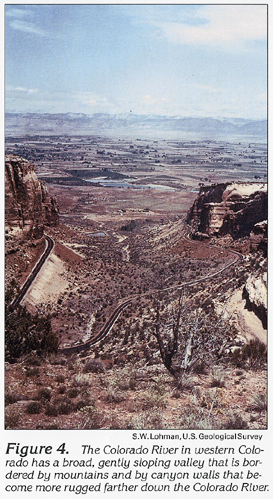
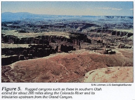
Farther westward, the mountains are less prevalent and are interspersed with broad structural basins. These basins and the broad valleys of the middle Colorado River and its tributaries form the irregular intermontane topography of the Colorado Plateaus Physiographic Province (fig. 4). Plateaus and high mesas are formed where the surface has been dissected by rugged canyons carved by the Colorado River and its tributaries (fig. 5). The largest of these canyons-the Grand Canyon-extends about 220 miles southwestward from the mouth of the Little Colorado River in Arizona and ranges from 4 to 18 miles in width and from 2,700 to 5,700 feet in depth below the rim.
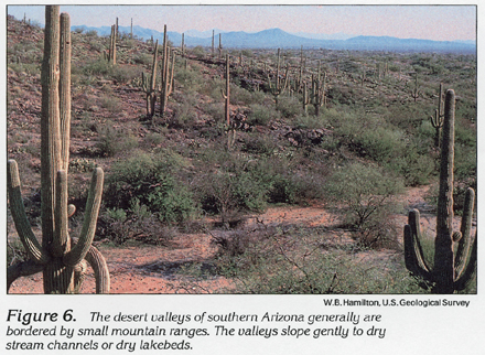
Small mountain ranges and intervening broad desert valleys of the Basin and Range Physiographic Province are prevalent to the west and south of the Colorado Plateaus in western Utah, southern Arizona, and southern New Mexico (fig. 1). These mountain ranges generally protrude 3,000 to 6,000 feet above the surrounding valley floor (fig. 6) and commonly extend from 20 to 50 miles in a north or northwesterly direction.
Small parts of the Middle Rocky Mountains and Wyoming Basin Physiographic Provinces extend into northwestern Colorado and northeastern Utah (fig. 1). The topography, geology, and hydrology of the two areas are described in Chapter 1 of this Atlas.
Four of the Nation's major river systems have headwaters in the mountainous areas of Segment 2. The South Platte River of the Missouri River system drains the eastern slope of northern Colorado; the Arkansas River and its tributary, the Canadian River, drain southeastern Colorado and northeastern New Mexico; the Rio Grande and its tributary, the Pecos River, drain south-central Colorado and central New Mexico; and the Colorado River and its tributaries drain Arizona, eastern Utah, Northwestern New Mexico, and western Colorado (fig. 1). Western Utah is drained by numerous streams that terminate in local desert basins, the Great Salt Lake, or other local lakes and reservoirs. Because the Great Salt Lake lies in the Great Basin, which is the largest closed basin in North America, it has no outlet to the sea. The salinity of the lake water is about 20 percent or about 6 times the salinity of seawater.
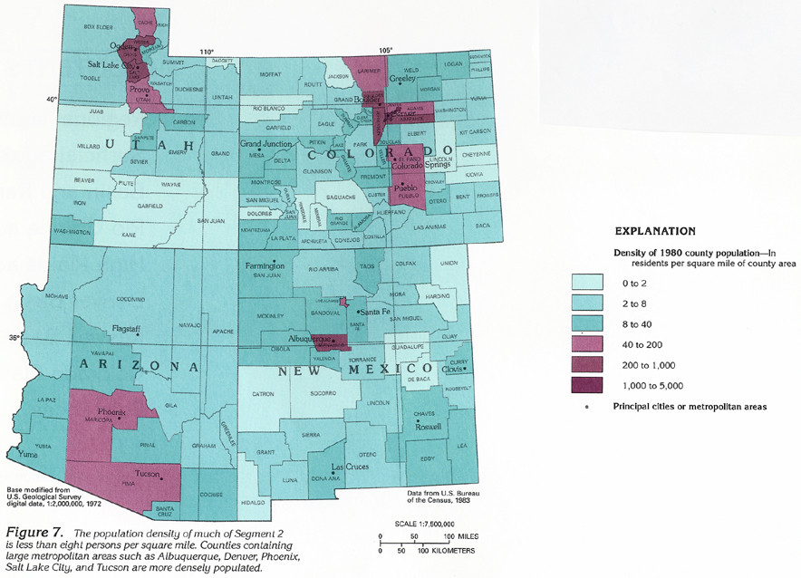
Most of Segment 2 is sparsely populated. The average population density of counties is less than 8 persons per square mile in about 65 percent of the four-State area (fig. 7). Population densities range from less than 0.5 person per square mile in a few rural counties to more than 4,000 persons per square mile in populous urban areas. The 1990 population of the four States was about 10 million; almost 70 percent of this population was in Arizona and Colorado. Most land in Segment 2 is undeveloped forest grassland, or desert shrubland, much of which is used for livestock grazing. Land used for production of commercial crops primarily is in eastern Colorado and eastern New Mexico.
CLIMATIC CONDITIONS
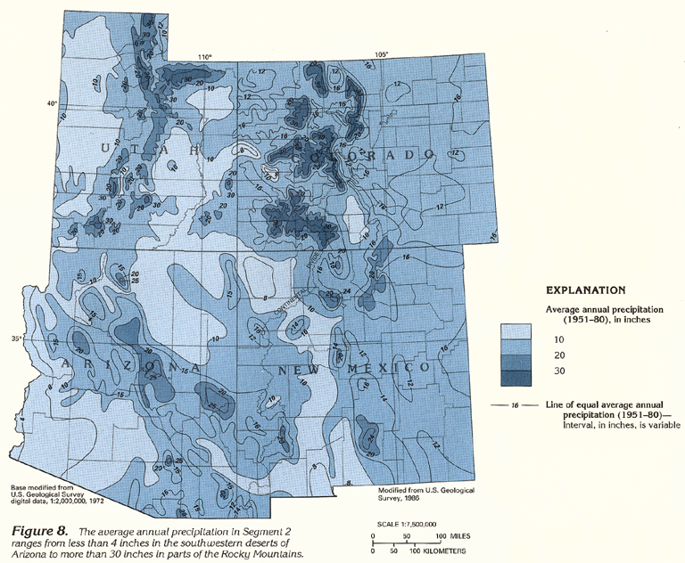
The varied topographic settings of Segment 2 have differing climatic conditions primarily because of differences in altitude. Temperature generally decreases and precipitation generally increases with increased altitude. The Great Plains, Colorado Plateaus, and Basin and Range Physiographic Provinces generally have abundant sunshine, moderate to high wind, low relative humidity, a large daily range in temperature, and little precipitation. In the Great Plains, about 60 to 80 percent of the annual precipitation falls during April to September, primarily from thunderstorms. Winter generally is the driest season. Average annual precipitation ranges from about 12 to 16 inches on the plains of New Mexico and Colorado (fig. 8). The slightly larger rates of precipitation near the eastern boundaries of Colorado and New Mexico are part of a general eastward increase in precipitation across the central part of the Nation.
The rugged and varied topography of the Colorado Plateaus causes diverse climatic conditions. Alpine climatic conditions may occur in the higher altitudes of the various mountain ranges in the area. Less precipitation and higher temperatures prevail at lower altitudes, where semiarid, desert-like conditions are present in some valleys and basins. Average annual precipitation ranges from about 8 to 16 inches in the plateau areas (4,000-9,000 feet altitude) to more than 30 inches in high mountain ranges (fig. 8). Most of the precipitation occurs in winter and spring and comes from eastward-tracking Pacific storm systems. Summer rainfall occurs almost entirely during brief, but often intense, thunderstorms that produce 20 to 40 percent of the annual precipitation. Winter storms produce either snow or rain in the southern valleys. In some mountainous areas, 10 feet or more of snowpack may accumulate.
Arid to semiarid climatic conditions exist in most of the Basin and Range area. Average annual precipitation ranges from less than 4 inches in southwestern Arizona to about 16 in western Utah. Rainfall occurs from widespread winter storms and from sporadic, local summer thunderstorms; many months may elapse between periods of measurable rainfall at a given location.
The climate of the Rocky Mountains is greatly affected by differences in altitude and, to a lesser extent, by the orientation of the mountain ranges and valleys with respect to the general eastward movement of storm systems that originate in the Pacific Ocean. Rain-shadow effects tend to decrease precipitation on leeward slopes of mountain ranges and to increase precipitation on windward slopes. The eastern slopes of the Continental Divide generally receive less precipitation than do the western slopes because of this rain-shadow effect.
Precipitation in the Rocky Mountains is more evenly distributed throughout the year than that in other physiographic provinces of Segment 2. Most precipitation occurs as snowfall from the large Pacific storm systems in the winter months; June is one of the driest months. Average annual snowfall ranges from about 5 feet to more than 35 feet. By August, most of the mountain snowpack has melted. Perennial snow fields occur in only a few small, sheltered areas at high altitude.
Some of the precipitation that falls on the land surface in Segment 2 flows directly into streams and rivers as direct runoff, and some precipitation infiltrates the soil and underlying aquifers and moves laterally to discharge into streams and rivers as baseflow. Direct runoff and baseflow are combined and mapped as average annual runoff in figure 9. In Segment 2, average annual runoff ranges from less than 0.2 inch to about 1 inch in most of the nonmountainous parts of the area. The small quantity of precipitation in this area, combined with relatively flat topography, porous soils, and general aridity causes most precipitation to be retained as soil moisture, which later evaporates or is transpired by plants rather than forming runoff. In the mountainous areas, the steeper topography, thin to nonexistent soils, cooler temperatures, and larger quantities of precipitation cause greater runoff, which can exceed 30 inches per year in some areas.
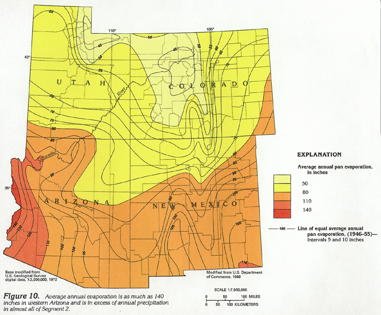
The generally clear skies, low relative humidity, wind, and moderate to high temperatures in the nonmountainous parts of Segment 2 cause large rates of evaporation. Much of the precipitation returns to the atmosphere through evaporation of surface water, transpiration by plants, or sublimation of snow and ice. The annual rate of potential evaporation, as measured by standard evaporation pans, ranges from about 45 inches in the mountainous areas of northern Utah and north-central Colorado to about 140 inches in southwestern Arizona (fig. 10). Potential annual evaporation generally exceeds average annual precipitation throughout Segment 9 and is as much as 35 times the annual precipitation in a small area along the Colorado River in southwestern Arizona. Evaporation greatly in excess of precipitation removes most surface water and soil moisture before the water can percolate below the root zone of plants and recharge an underlying aquifer.
Recharge from precipitation generally ranges from zero to a few inches per year in Segment 2 but is extremely variable because it is affected by such factors as aquifer depth, thickness and permeability of soil and confining layers, land-surface slope and aspect, precipitation intensity and duration, and the temperature, wind, and relative humidity. In the parts of Segment 2 where geologic conditions do not preclude recharge, recharge from precipitation might only occur during the snow melting of a winter snowpack or during an extended period of winter rainfall when excess soil moisture is maintained.
MAJOR AQUIFERS AND AQUIFER SYSTEMS
All or part of six major aquifers or aquifer systems are present in Segment 2 (fig. 11). Four are in relatively unconsolidated sediments of Tertiary, Cretaceous, or older age. A small part of a seventh aquifer, the Pecos River Basin alluvial aquifer, is present in extreme southeastern New Mexico, and extends into Texas. This aquifer is discussed in Chapter E of this Atlas, which pertains to Texas and Oklahoma.
The three aquifers or aquifer systems in unconsolidated sediments are (1) the Basin and Range aquifers in southern Arizona and western Utah, (2) the Rio Grande aquifer system of southern Colorado and central New Mexico, and (3) the High Plains aquifer of eastern Colorado and eastern New Mexico.
Surficial aquifers occur primarily at shallow depth in unconsolidated sediments along parts of major river valleys in segment 2. Individual stream-valley aquifers mostly are small and separate from aquifers in other valleys or from distant aquifers in the same valley. Only in the valleys of the South Platte and the Arkansas Rivers of eastern Colorado are the aquifers large and continuous enough to form a major aquifer; therefore, the stream-valley aquifers are not mapped in figure 11.
The Basin and Range aquifers and the Rio Grande aquifer system generally consist of unconsolidated gravel, sand, silt, and clay, or partly consolidated sedimentary or volcanic materials. These materials have filled deep fault-block valleys formed by large vertical displacement across faults. Mountain ranges that generally consist of impermeable rocks separate adjacent valleys. When mountains encircle a valley, the aquifer in the valley is isolated, and ground water is contained within the valley. However, most valleys are interconnected, and ground water moves from valley to valley through the interconnected network of aquifers. The Basin and Range aquifers extend westward beyond Segment 2 into California, Nevada, Oregon, and Idaho; the Rio Grande aquifer system extends southward beyond Segment 2 into Texas and Mexico.
The High Plains aquifer of eastern Colorado and eastern New Mexico extends over a large area and is little affected by faulting and deformation. The primarily unconsolidated to poorly consolidated sediments of this aquifer extend beyond Segment 2 into parts of Kansas, Nebraska, Oklahoma, South Dakota, Texas, and Wyoming.
The three consolidated-rock aquifers or aquifer systems are (1) in the Denver Basin of east-central Colorado, (2) the Roswell Basin of southeastern New Mexico, and (3) the Colorado Plateaus of northern Arizona, western Colorado, northwestern New Mexico, and eastern Utah.
The Denver Basin aquifer system consists of a layered sequence of four aquifers in beds of permeable conglomerate, sandstone, and siltstone. Layers of relatively impermeable shale separate the aquifers and impede the vertical movement of ground water between the aquifers. The northern part of this aquifer system underlies the surficial aquifer of the South Platte River. Although the Denver Basin aquifer system and the surficial aquifer are hydraulically connected in part of this area, they primarily function as separate aquifer systems.
The Roswell Basin aquifer system consists of an underlying carbonate-rock aquifer and a hydraulically connected, overlying alluvial aquifer. The carbonate-rock aquifer primarily has been formed by solution openings in extensive limestone and dolomite formations of Permian age. The alluvial aquifer is in unconsolidated gravel, sand, silt, and clay that overlies the eastern part of the carbonate-rock aquifer. The alluvial aquifer hydraulically connects the carbonate-rock aquifer with surface flow in the Pecos River, which flows through the Roswell Basin.
The Colorado Plateaus aquifers are contained in a thick sequence of poorly to well-consolidated conglomerate, sandstone, siltstone, and shale. Volcanic rocks, carbonate rocks, and evaporite deposits in the area also can yield water to wells. Structural deformation, faulting, and lateral changes in the lithology of the rocks have produced a complex sequence of water-yielding layers.
Some parts of Segment 2 are shown in figure 11 as having no major aquifers. In some areas, aquifers either do not exist or yield too little water to wells to be significant. In other areas, small aquifers yield sufficient water to supply local requirements but are not extensive enough to be classified as a major aquifer.
GEOLOGY
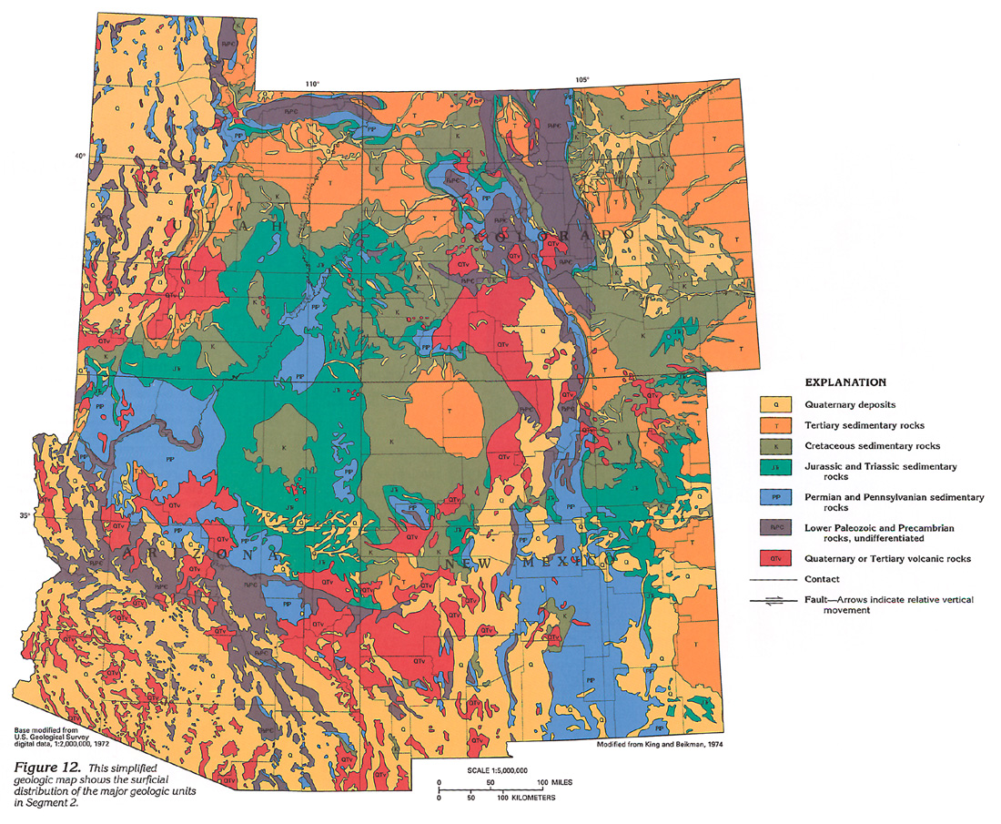
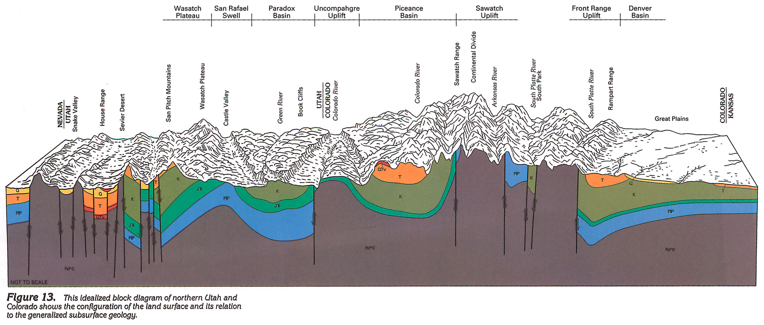
Aquifers in Segment 2 are present in geologic units that are varied and complex (fig. 12) primarily because of extensive deformation of the Earth's crust associated with the uplift of the Rocky Mountains. Prior to the mountain-building uplifts, most of the area was covered by an extensive layer of sediments that had been deposited during the previous millions of years. These layers of sediment were gradually buried and altered to form layers of rock. Today, the Great Plains area of eastern Colorado and eastern New Mexico is still underlain by a relatively flat and undeformed sequence of these rocks (fig. 13).
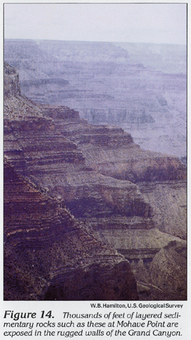
The most recent uplift of the Rocky Mountains, which began about 70 million years ago, faulted, deformed, and elevated the land surface and the underlying ordered layers of rock. Faulting was prevalent, and a few faults developed more than 20,000 feet of vertical offset. As uplift continued, erosion removed the uppermost rocks and, in some areas, exposed the underlying crystalline-rock core of the mountains. Today these older crystalline rocks form many of the principal mountain ranges in Segment 2. Uplift of the Colorado Plateaus steepend stream gradients and accelerated the downcutting of the Colorado River and its principal tributaries. Downcutting of the Colorado River in the Grand Canyon has exposed thousands of feet of sedimentary rocks (fig. 14).
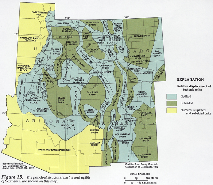
Broad structural basins, such as the Black Mesa, San Juan, Piceance, and Uinta (fig. 15), were formed between some of the uplifted areas. These basins generally contain an underlying, relatively undeformed sequence of rock that was deposited in the area prior to uplift and an overlying younger layer of rock and sediment that was derived from the erosion of nearby uplifted areas. Smaller basins formed by block faulting developed when a block of the Earth's crust was displaced downward with respect to adjacent uplifted blocks. Some of these basins contain older sedimentary rocks or volcanic rocks, and almost all contain a thick overlying sequence of Tertiary and Quaternary sediment derived from erosion of nearby uplifted blocks. The Basin and Range Province of western Utah and southern Arizona and the Rio Grande Rift area of central New Mexico contain many of these basins.
Rocks of various geologic age have a wide surficial distribution (fig. 12) because of the depositional history and deformation of the area. Deformation caused extensive faulting, and faults commonly separate adjacent geologic units as indicated in figure 13. Because faults or fault zones are numerous or complex, they are not shown on the regional map (fig. 12). Younger (Quaternary and Tertiary) geologic units generally are less consolidated than the older units and can form more permeable aquifers. Older (Early Paleozoic and Precambrian) geologic units generally are crystalline or well consolidated and do not readily yield water except from faults, fractures, or solution openings.
FRESH GROUND-WATER WITHDRAWALS
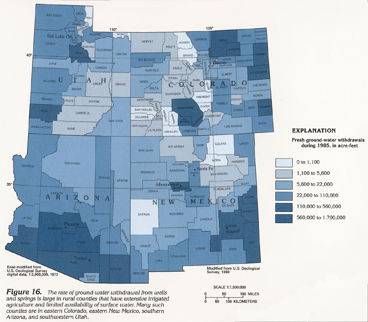
During 1985, about 31,000,000 acre-feet of water was used in Segment 2; about 28 percent, or 8,700,000 acre-feet of this water was supplied from ground-water sources. (One acre-foot is the volume of water that will cover 1 acre of land to a depth of 1 foot, or about 43,560 cubic feet of water.) The 1985 rate of ground-water withdrawal within counties ranged from less than 1,000 to about 1,700,000 acre-feet (fig. 16). Counties that had small rates of ground-water withdrawal generally are in the mountains or the Colorado Plateaus, where small population and little irrigated agriculture limit water requirements. Surface water is more commonly available in the mountains and along larger rivers, where it can be used in preference to ground water. Rural counties that have large rates of ground-water withdrawal commonly have extensive irrigated agriculture and little surface water. Irrigated agriculture and a large population cause large water demands in parts of Utah and southern Arizona, where ground water is an important source of supply.
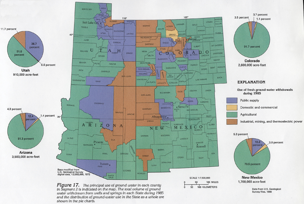
During 1985, irrigation of commercial crops and watering of livestock were the largest uses of ground water in Segment 2. Such agricultural use ranged from 51 percent of all ground water withdrawn in Utah to 92 percent of all ground water withdrawn in Colorado (fig. 17). Ground water withdrawn for public supply was the second largest use of water in Segment 2. Public water supplies obtained from ground water constituted as little as 4 percent of the total 1985 withdrawal in Colorado to as much as 37 percent of the total 1985 withdrawal in Utah. Ground water withdrawn for mining was the principal use of ground water in several counties, primarily in mountainous areas.