INTRODUCTION
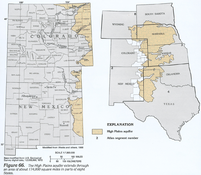
The High Plains aquifer underlies an area of about 174,000 square miles that extends through parts of Colorado, Kansas, Nebraska, New Mexico, Oklahoma, South Dakota, Texas, and Wyoming. The aquifer is the principal source of water in one of the major agricultural areas of the United States. About 20 percent of the Nation's irrigated agricultural land overlies the High Plains aquifer, and about 30 percent of the ground water used for irrigation in the Nation is withdrawn from the High Plains aquifer. In 1980, about 17,800,000 acre-feet of water was withdrawn from the aquifer to irrigate about 13,000,000 acres of cropland. The boundary of the aquifer approximates the boundary of the Great Plains Physiographic Province. The province is characterized by a flat to gently rolling land surface and moderate precipitation.
The geology and hydrology of the 24,000-square-mile area of the High Plains aquifer located in eastern Colorado and eastern New Mexico is discussed in this Chapter (fig. 66). Additional discussion of the geology and hydrology of other areas of the aquifer is contained in Chapter D (Kansas and Nebraska), Chapter E (Oklahoma and Texas), and Chapter I (South Dakota and Wyoming) of this Atlas.
In eastern Colorado and New Mexico, the High Plains aquifer generally is not hydraulically connected to other principal aquifers. The alluvial aquifers of the South Platte, Arkansas, and Canadian River valleys generally are located beyond the boundary of the High Plains aquifer. Where the two aquifer systems are in close proximity, as in easternmost Colorado, some ground water may flow from the High Plains aquifer to the alluvial aquifers.
The bedrock formations underlying the High Plains aquifer primarily consist of relatively impermeable shale. In some areas, water-yielding sandstone is interlayered with the shale near the base of the High Plains aquifer. These sandstone aquifers can yield large volumes of water to wells and be of local importance, but they lack the areal extent to constitute a principal aquifer.
HYDROGEOLOGIC UNITS
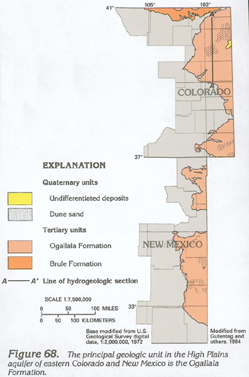
The High Plains aquifer consists of near-surface deposits of unconsolidated or partly consolidated gravel, sand, silt, or clay of Tertiary or Quaternary age. Tertiary geologic units consist of the Brule Formation of the White River Group, the Arikaree Formation, and the Ogallala Formation. Quaternary sediments include alluvial deposits, loess, dune sand, and valley-fill deposits (fig. 67); the loess is not an aquifer.
The Quaternary sediments consist of unconsolidated gravel, sand, silt, and clay deposited by streams or sand and silt deposited by wind. These deposits form part of the High Plains aquifer where they are saturated and are in contact with underlying aquifer units of Tertiary age. In eastern Colorado and New Mexico, the saturated Quaternary sediments generally are thin and discontinuous. Undifferentiated Quaternary sediments are hydraulically connected with the underlying aquifer in Tertiary units and are shown separately in figure 68 only in areas where they do not overlie Tertiary aquifer units. The extent of the saturated Tertiary units defines the western boundary of the aquifer.
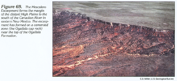
The Ogallala Formation is the principal geologic unit in the High Plains aquifer in eastern Colorado and New Mexico. The Ogallala generally consists of an unconsolidated and poorly sorted sequence of gravel, sand, silt, and clay. Moderately to well-cemented zones within the Ogallala are resistant to weathering and form ledges in outcrop areas. The most distinctive of these ledges, the Ogallala cap rock, is near the top of the Ogallala in large areas of New Mexico (fig. 69), where it can be as thick as 60 feet.
The Arikaree Formation underlies the Ogallala Formation in parts of northeastern Colorado and consists of a massive, very fine to fine sandstone and localized beds of volcanic ash, siltstone, claystone, and marl. Wells completed in thc Arikaree Formation generally do not yield large volumes of water unless the formation has been extensively fractured.
The Brule Formation of the White River Group underlies the Arikaree Formation and crops out in northeastern Colorado north of the South Platte River. The Brule primarily consists of massive siltstone containing beds of sandstone, volcanic ash, claystone, and fine sand. It is relatively impermeable and is not part of the High Plains aquifer except in those areas where the rock has been extensively fractured. In northeastern Colorado, the Brule typically yields less than 300 gallons per minute to wells; however, yields as large as 1,500 gallons per minute have been reported.
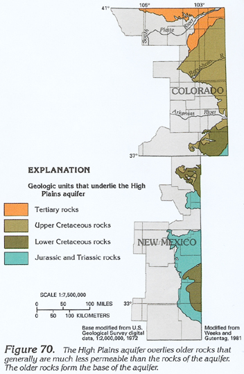
Rocks that directly underlie the High Plains aquifer consist of the White River Group of Tertiary age (including the Brule Formation where it is unfractured and relatively impermeable) and rocks of Cretaceous, Jurassic, and Triassic age (fig. 70) that are mostly shale and interlayered sandstone, claystone, limestone, and dolomite. The Pierre Shale of Late Cretaceous age forms an impermeable base to the High Plains aquifer in much of Colorado. The thickness of the Pierre Shale increases from zero near the Arkansas River to more than 4,000 feet near the western edge of the aquifer in central Colorado. In southeastern Colorado and eastern New Mexico, the High Plains aquifer is underlain by shale and interlayered sandstone, claystone, limestone, and dolomite of relatively low permeability. Permeable zones within some of these rocks may yield usable volumes of water to wells in some local areas.
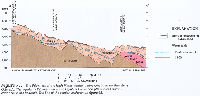
The thickness of the Ogallala Formation that underlies the High Plains of eastern Colorado and New Mexico is highly irregular. The Ogallala was deposited by ancient streams that flowed eastward from the Rocky Mountains. The aggrading streams deposited gravel, sand, silt, and clay in the stream valleys that had been eroded into the pre-Ogallala land surface. Eventually, the valleys were filled and buried, and thick deposits of Ogallala sediments extended over a vast area. Subsequent changes in geologic and climatic conditions caused streams to begin degrading, and new stream valleys were eroded into the surface of the Ogallala sediments. Present stream valleys of eastern Colorado and New Mexico do not necessarily correspond to the location of the ancient stream valleys. The resulting thickness of the Ogallala sediments is irregular (fig. 71) and ranges from 0 to about 500 feet in a few buried valleys. Ogallala sediments are thinner near the margins of the aquifer and near high areas of the bedrock surface.
RECHARGE AND DISCHARGE
Water in the High Plains aquifer of eastern Colorado and New Mexico primarily is derived from infiltration of precipitation or seepage from intermittent surface flow in streams. The rate of precipitation recharge varies from area to area in response to changes in climatic, soil, and topographic conditions.
Most precipitation is lost to evaporation from the soil or is transpired by vegetation before it can percolate to the water table and recharge the aquifer. Average annual precipitation ranges from about 12 to 16 inches in eastern Colorado and New Mexico; pan evaporation ranges from about 60 inches per year in northern Colorado to about 105 inches per year in southeastern New Mexico and greatly exceeds annual precipitation. Most precipitation recharge likely occurs during periods of snowmelt or prolonged rainfall when water is available for percolation and evapotranspiration rates are small.
Soil conditions affect recharge rates by impeding downward water movement. In deep, well-sorted, sandy soils or sand dunes, water can readily percolate to depths sufficient to prevent further loss to evapotranspiration. Most of this water will ultimately recharge the aquifer; thus, sandy soils are important sources of recharge. In clayey soils, percolation is slow, and most soil water is held at shallow depth, where it can be lost to evapotranspiration. In some areas of eastern Colorado and southeastern New Mexico, shallow, consolidated rocks or caliche deposits consisting of a well-cemented layer of subsoil retard deep percolation and hinder recharge.
Intense precipitation produces surface runoff that can accumulate in local depressions or contribute to streamflow. High flow in the ephemeral streams that cross the aquifer in Colorado and New Mexico is an important source of recharge. Most of the stream channels are located above the water table, and the streams lose water first to the sandy alluvial deposits in the channels, and subsequently to the underlying High Plains aquifer. High flow in the normally dry stream channels is uncommon, and significant recharge in these areas generally occurs only at intervals of many years.
The average rate of recharge to the High Plains aquifer in Colorado and New Mexico was about 196,000 acre-feet per year before development of irrigated agriculture. About two-thirds of the recharge occurred in the larger area of the aquifer in Colorado. Recharge rates of about 0.07 inch per year were common in much of the area, but as much as 0.8 to 1.0 inch of water per year might have recharged the aquifer near some streams and between the South Platte and Republican Rivers, where flat-lying sandy soil and larger rates of annual precipitation are common. After agricultural development, infiltration of irrigation water applied to fields that overlie the aquifer became another source of recharge.
Most ground water is discharged from the aquifer by underflow, withdrawal, and evapotranspiration. Water discharges from the aquifer in Colorado and New Mexico by subsurface flow (underflow) into Nebraska, Kansas, Oklahoma, and Texas. Ground-water withdrawal from wells is another major means of discharge. Evapotranspiration by phreatophytes in areas of shallow water table is a minor means of discharge in eastern Colorado and New Mexico.
WATER-LEVEL CONDITIONS
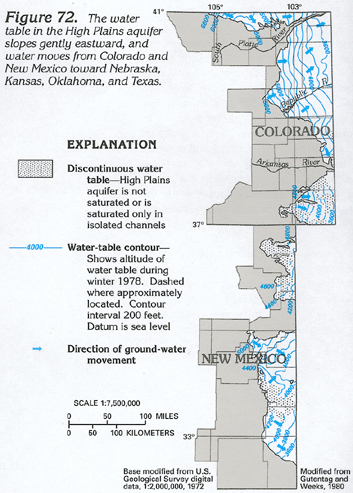
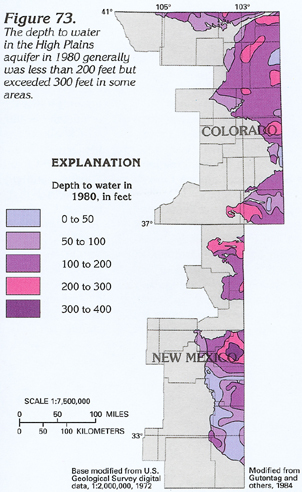
The altitude and configuration of the water table in the High Plains aquifer is most affected by the altitude and configuration of the underlying bedrock surface, the transmissivity of the aquifer, and the rate and distribution of recharge and discharge. As indicated in figure 72, large areas of the aquifer are not continuously saturated or are saturated only in isolated channels in the bedrock surface. In other parts of the aquifer, the water table is continuous and slopes eastward at gradients of about 10 to 40 feet per mile. The water-table altitude ranges from about 6,800 feet at the northern edge of the aquifer in Colorado to about 3,600 feet at the eastern boundary of Colorado and New Mexico. Ground water generally moves downgradient at right angles to the water-table contours. A general eastward movement of water is indicated in the figure, but the local direction of movement is complex due to local changes in the bedrock surface and recharge and discharge. Depth to water in the aquifer is less than 50 feet in parts of New Mexico but generally ranges from 50 to 400 feet (fig. 73).
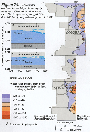
Water levels in the High Plains aquifer have declined in most places since irrigation withdrawal became widespread. Predevelopment to 1980 water-level declines exceeded 25 feet in parts of Colorado and 100 feet in parts of New Mexico (fig. 74). Water-level changes were between 10 feet of rise and 10 feet of decline over about 78 percent of the aquifer in Colorado and about 62 percent of the aquifer in New Mexico.
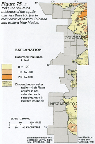
The decrease in saturated thickness caused by the water-level declines produced a reduction of about 15,000,000 acre-feet in the volume of ground water in storage in the aquifer in Colorado and New Mexico. In Colorado, about 5 percent of the original volume of ground water in storage was withdrawn between predevelopment and 1980. In New Mexico, about 16 percent of the original volume of ground water in storage was withdrawn between predevelopment and 1980. The decrease in saturated thickness exceeded 25 percent of the original saturated thickness in some south-central parts of eastern New Mexico. Saturated-thickness decreases generally did not exceed 25 percent in eastern Colorado and were less than 10 percent in most areas. The saturated thickness of the aquifer ranges from less than 1 foot, primarily near the western aquifer boundary, to about 400 feet in eastern Colorado (fig. 75). The saturated thickness is irregular because of the uneven surface of the base of the aquifer (fig. 71) and differences in water-table altitude (fig. 72).
In 1990, the part of the High Plains aquifer in Colorado contained about 108,000,000 acre-feet of recoverable ground water in storage. In New Mexico, the aquifer contained about 47,000,000 acre-feet. The 155,000,000 acre-feet in eastern Colorado and eastern New Mexico was only about 5 percent of the total recoverable water in the High Plains aquifer in the eight-State area where it is present.
AQUIFER CHARACTERISTICS
Hydraulic conductivity is a measure of the ease with which sediments can transmit water. The average hydraulic conductivity of the High Plains aquifer in Colorado and New Mexico is about 60 feet per day and ranges from less than 1 to more than 100 feet per day (fig. 76). Differences in hydraulic conductivity are the result of differences in the particle size, shape, sorting, and cementation of the aquifer materials. The High Plains aquifer in eastern Colorado and eastern New Mexico has an average saturated thickness of about 75 feet; the average transmissivity of the aquifer is about 4,500 feet squared per day.
GROUND-WATER QUALITY
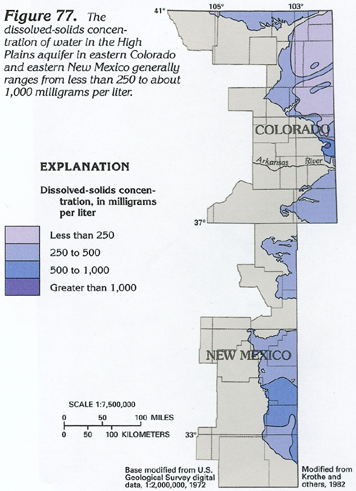
The agricultural economy of the High Plains is based on the availability of large quantities of ground water of quality suitable for irrigation. Large concentrations of dissolved solids in the water can retard plant growth. Most crops can tolerate water with as much as 500 milligrams per liter dissolved solids and can tolerate water with 500 to 1,500 milligrams per liter or more if the soils are well drained.
The dissolved-solids concentration of water in the aquifer in eastern Colorado and eastern New Mexico generally is less than 500 milligrams per liter but exceeds 1,000 milligrams per liter in a small area of Colorado (fig. 77). Concentrations less than 250 milligrams per liter in northeastern Colorado are the result of relatively large rates of recharge in areas of sandy soil that contains few soluble minerals. The area with large dissolved-solids concentrations north of the Arkansas River is likely caused by dissolution of gypsum (calcium sulfate) in the Upper Cretaceous bedrock that underlies the aquifer. Ground water in this area contains more than 1,000 milligrams per liter of dissolved sulfate. The area with large dissolved-solids concentrations in southeastern New Mexico is likewise due to the effects of the underlying bedrock. In this area, Lower Cretaceous, Jurassic, and Triassic rocks that underlie the High Plains aquifer contain highly mineralized water that may discharge into and degrade the water quality of the High Plains aquifer.
Most ground water in the aquifer is a calcium magnesium bicarbonate type. In parts of southeastern New Mexico and in the area with large dissolved-solids concentrations north of the Arkansas River in Colorado, dissolved sulfate is the principal anion, and local ground water is either a calcium magnesium sulfate or a bicarbonate sulfate type.
FRESH GROUND-WATER WITHDRAWALS
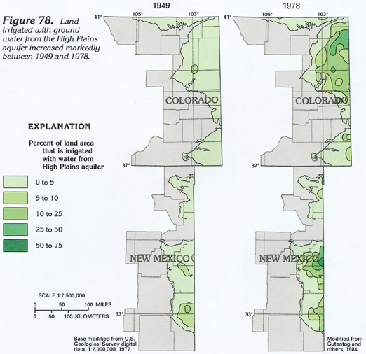
The development of irrigation on the High Plains has transformed the area into one of the principal agricultural regions of the Nation. Irrigation with ground water began in the 1800's with the use of windmill-powered pumps; large-scale groundwater withdrawal did not begin until after the drought of the 1930's. Drought, technological advances in well drilling and pumping equipment, and favorable economic factors led to the large-scale irrigation of nearly level land overlying a shallow water table. By 1949, from 0 to 10 percent of the land that overlies the aquifer in Colorado and New Mexico (fig. 78) was irrigated with ground water. Further advances in drilling and pumping technology and the increasing availability of low-cost energy enabled development of ground water in areas of greater depth to water. The introduction of center-pivot irrigation systems in the 1960's made irrigation of rolling terrain and sandy soils practical. In 1978, the increase in irrigated acreage in the northern part of the High Plains (fig. 78) primarily was the result of center-pivot technology. By 1980, the High Plains aquifer in Colorado supplied water to about 770,000 acres from about 4,000 wells. In New Mexico, the aquifer supplied water to about 320,000 acres from about 6,000 wells. Ground-water withdrawal during 1980 was about 985,000 acre-feet in Colorado and about 519,000 acre-feet in New Mexico. About 99 percent of the water withdrawn from the High Plains aquifer was used for irrigation in 1985.
The 1,504,000 acre-feet of water withdrawn from the High Plains aquifer during 1980 in Colorado and New Mexico greatly exceeded the 196,000 acre-feet per year of natural recharge to the aquifer in these States. Annual withdrawal probably has exceeded annual natural recharge since the mid-1960's. Long-term withdrawal from an aquifer that exceeds recharge will cause a long-term decline in water levels and a decrease in saturated thickness.
EFFECTS OF WITHDRAWAL
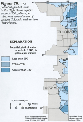
Because water-level declines in the High Plains aquifer have been large, they have substantially decreased the saturated thickness of the aquifer in some areas. As water levels decline, costs to obtain water increase as the result of the need for deeper wells, larger pumps, and larger energy expenditure to lift the water to the surface. As saturated thickness decreases, well yield also decreases, and additional wells can be required to maintain a constant rate of withdrawal. Although several factors are involved, a well capable of producing 250 gallons per minute can irrigate about 40 acres; a well capable of producing 750 gallons per minute can irrigate about 160 acres and effectively operate a center-pivot irrigation system on a quarter section of land. Potential well yields of more than 750 gallons per minute may be obtainable in parts of eastern Colorado and eastern New Mexico (fig. 79). As the cost of water increases, irrigated agriculture becomes less economical, and the future of this important agricultural area could become uncertain.