INTRODUCTION
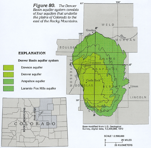
The Denver Basin aquifer system supplies water to rural and suburban residents of much of the plains area along the eastern front of the Rocky Mountains in northeastern Colorado (fig. 80). The aquifer system underlies an area of about 7,000 square miles that extends from Greeley south to near Colorado Springs and from the Front Range east to near Limon. The geologic formations that compose the Denver Basin aquifer system are Cretaceous and Tertiary sandstone, conglomerate, and shale of the Fox Hills Sandstone, Laramie Formation, Arapahoe Formation, Denver Formation, and Dawson Arkose. These formations are separated from the deeper and less permeable Paleozoic and other Mesozoic rocks in the area by an approximately 6,000-foot-thick layer of nearly impermeable Cretaceous shale, predominantly the Pierre Shale. Although the permeable Cretaceous and Tertiary rocks extend into the subsurface north of Greeley and into Wyoming, they are little utilized, poorly defined, and are not major aquifers in the part of Colorado north of Greeley. These formations are important water-yielding units in parts of Wyoming and are described in Chapter I of this Atlas.
The Denver Basin aquifer system is not well connected to other major aquifers in the area. The surficial aquifer along the South Platte River Valley is the only other major aquifer near the Denver Basin. The surficial aquifer directly overlies the Denver Basin aquifer system only along the valley of the South Platte River from Denver to just east of Greeley, Colo. From east of Greeley, the alluvium along the South Platte River is in an ancestral valley eroded into Pierre Shale and, thus, is hydraulically isolated from the Denver Basin aquifer system.
Shallow, discontinuous surficial aquifers overlie parts of the Denver Basin aquifer system, primarily along small streams that extend South from the South Platte River. The surficial aquifers generally are thicker and more extensive in the northern one-half of the Denver Basin, where they supply water for irrigation, stock, and domestic use. The surficial aquifers are not important sources of water in most other areas of the basin.
Some permeable sandstones in the thick series of rock below the Pierre Shale receive recharge from outcrops along the western margin of the basin. Some of these sandstones extend into Nebraska and Kansas, where they are shallower and are important aquifers. In Colorado, however, these sandstones generally are deeply buried, can contain poor-quality water, and are little utilized as sources of water.
HYDROGEOLOGIC UNITS
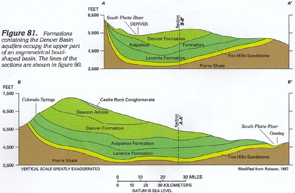
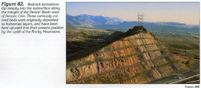
The Denver Basin aquifer system consists of four aquifers (fig. 80) that are present in five geologic formations. As shown in the geologic sections in figure 81, the five formations form a layered sequence of rock in an elongated, asymmetrical structural depression. The structure of the formations is asymmetrical because rocks near the western edge of the basin dip more steeply than rocks near the eastern edge of the basin (figs. 81, 82). The differences in dip and the overall shape of the basin are the result of the uplift of the Rocky Mountains, which followed deposition of most of the Cretaceous formations in the Denver Basin.
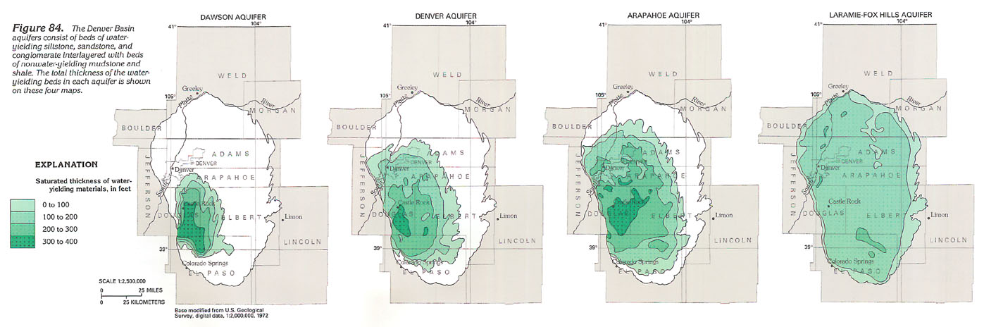
The Dawson Arkose (fig. 83) contains the Dawson aquifer and is the uppermost and least extensive water-yielding formation in the Denver Basin. The Dawson aquifer extends over an area of about 1,200 square miles between Denver and Colorado Springs. The sediments that form the Dawson aquifer primarily consist of coarse-grained, poorly to well-consolidated sandstones interbedded with conglomerate, siltstone, and shale. Individual conglomerate or sandstone beds commonly are lens-shaped and range in thickness from a few inches to as much as 200 feet. Saturated thickness of the aquifer is 300 to 400 feet in the central part of the formation (fig. 84).
The Denver Formation contains the Denver aquifer (fig. 83), which extends through an area of about 3,000 square miles and underlies the city of Denver, Colo. The Denver Formation is a 600- to 1,100-foot-thick sequence of moderately consolidated, interbedded shale, claystone, siltstone, and sandstone, in which coal and fossilized plant remains are common. Water-yielding layers of sandstone and siltstone occur in poorly defined irregular beds that are dispersed within relatively thick sequences of claystone and shale. Individual sandstone and siltstone layers commonly are lens-shaped and range in thickness from a few inches to as much as 50 feet. Although the Denver aquifer yields usable quantities of water to wells, claystone and shale are prevalent in this unit and tend to form a leaky confining layer between the overlying Dawson aquifer and the underlying Arapahoe aquifer.
The Arapahoe Formation consists of a 400- to 700-foot-thick sequence of interbedded conglomerate, sandstone, siltstone, and shale. It contains the Arapahoe aquifer (fig. 83), which extends over an area of about 4,300 square miles or about two-thirds the area of the Denver Basin aquifer system (fig. 80). The top of the Arapahoe aquifer is defined by the base of shale beds in the lower part of the overlying Denver Formation; the base of the Arapahoe aquifer is defined by the top of the shale, coal seams, and thin beds of sandstone and siltstone in the upper part of the underlying Laramie Formation. The upper part of the Laramie Formation forms a nearly impermeable confining layer that is 300 to 400 feet thick and impedes water movement between the Arapahoe aquifer and the underlying Laramie-Fox Hills aquifer.
In some areas the Arapahoe aquifer can be divided into an upper, somewhat shalier part and a lower, somewhat sandier part. Individual conglomerate and sandstone beds in the aquifer commonly are lens-shaped, moderately consolidated, and range in thickness from a few inches to 30 or 40 feet. The beds are so closely spaced that they form a single hydrologic unit that is 200 to 300 feet thick in some areas.
The Fox Hills Sandstone and sandstones in the lower part of the Laramie Formation form the Laramie-Fox Hills aquifer (fig. 83). The Laramie-Fox Hills aquifer underlies all of the approximately 7,000-square-mile Denver Basin. The aquifer is underlain by the nearly impermeable Pierre Shale, which forms the base of the aquifer system. The thickness of the Laramie-Fox Hills aquifer ranges from 0 to about 300 feet (fig. 84).
The Laramie-Fox Hills aquifer generally consists of beds of fine- to very fine-grained sandstone or siltstone interbedded with shale. Deeply buried beds of sandstone and siltstone generally are friable and light to medium gray. In outcrops, sandstone and siltstone range from friable to very hard, depending on the presence of iron mineralization.
RECHARGE AND DISCHARGE
The Denver Basin has a semiarid climate in which potential annual evaporation is about five times larger than annual precipitation. Most precipitation that falls on the land surface runs off in streams, is evaporated from the soil surface, or is consumed by vegetation. However, a small part of the precipitation usually percolates downward and recharges the groundwater system. In the Denver Basin, most recharge occurs in the highland areas between stream channels in the topographically higher southern part of the basin. Precipitation is greater in this area, and the permeable soils derived from the Dawson Arkose enable deep percolation. Recharge in this area can occur on a local and a regional scale. On a local scale, water moves from the highland recharge areas through shallow sandstone beds and discharges in nearby stream valleys. Because it follows short flow paths, this water primarily affects ground-water levels only in a local area. On a regional scale, water moves from the recharge areas into deeper parts of the aquifer and can move great distances through the aquifer before reaching a point of discharge many miles away.
Recharge and discharge also can result from water moving upward or downward through confining units of mudstone or shale located within or between the aquifers. In the central part of the basin, water levels in shallower wells generally are higher than those in deeper wells, creating the potential for water to move downward from the shallower aquifers to the deeper aquifers. Such water-level differences between adjacent aquifers indicate the direction ground water can move vertically, but do not indicate how much movement, if any, is actually occurring. Mudstone and shale beds in the Dawson, Denver, and Arapahoe aquifers allow some vertical water movement through or around the beds. In contrast, shale in the upper part of the Laramie Formation is thick, relatively impermeable, and areally extensive; water generally does not move vertically across this confining unit even if water-level differences exist.
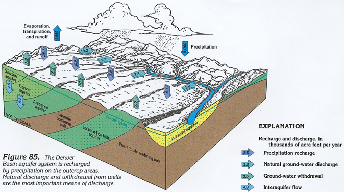
The principal means of ground-water discharge from the Denver Basin aquifers are withdrawal from wells and inter-aquifer movement of water from the bedrock to overlying alluvial aquifers. Estimated ground-water withdrawal from the bedrock aquifers increased from about 14,000 acre-feet per year during 1960 to about 29,000 acre-feet per year during 1980. Water discharged to alluvial aquifers can contribute to the flow in those aquifers or streams adjacent to them or can be lost to evapotranspiration.
On average, about 5,000,000 acre-feet of water falls as precipitation each year on the Denver Basin (fig. 85). About 4,960,000 acre-feet of this water is lost to evaporation, transpiration by plants, or surface runoff. The remaining water, about 40,000 acre-feet, recharges the four Denver Basin aquifers. During 1958-78, about 45,000 acre-feet of water per year was discharged from the aquifers-26,000 acre-feet by natural discharge to alluvial aquifers, springs, and evaporation and about 19,000 acre-feet to pumping wells. A net quantity of about 4,800 acre-feet of water flowed from the Dawson aquifer to the Denver aquifer; a net quantity of about 8,200 acre-feet of water flowed from the Denver aquifer to the Arapahoe aquifer. Thick shale beds prevent most water movement across the upper part of the Laramie Formation and the Pierre Shale.
WATER-LEVEL CONDITIONS
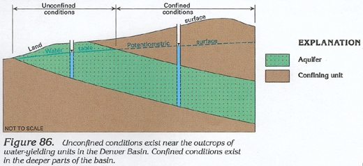
Unconfined and confined conditions are present in the bedrock aquifers of the Denver Basin. The aquifers are unconfined primarily near outcrops (fig. 86), where the water table may be at relatively shallow depth. The aquifers are confined in the deeper parts of the basin where confining units restrict vertical movement of water and cause water levels in wells to rise above the top of the aquifer. The surface defined by the water level in wells in either confined or unconfined parts of an aquifer is called a potentiometric surface. (In an unconfined aquifer, the potentiometric surface also is called a water table.)
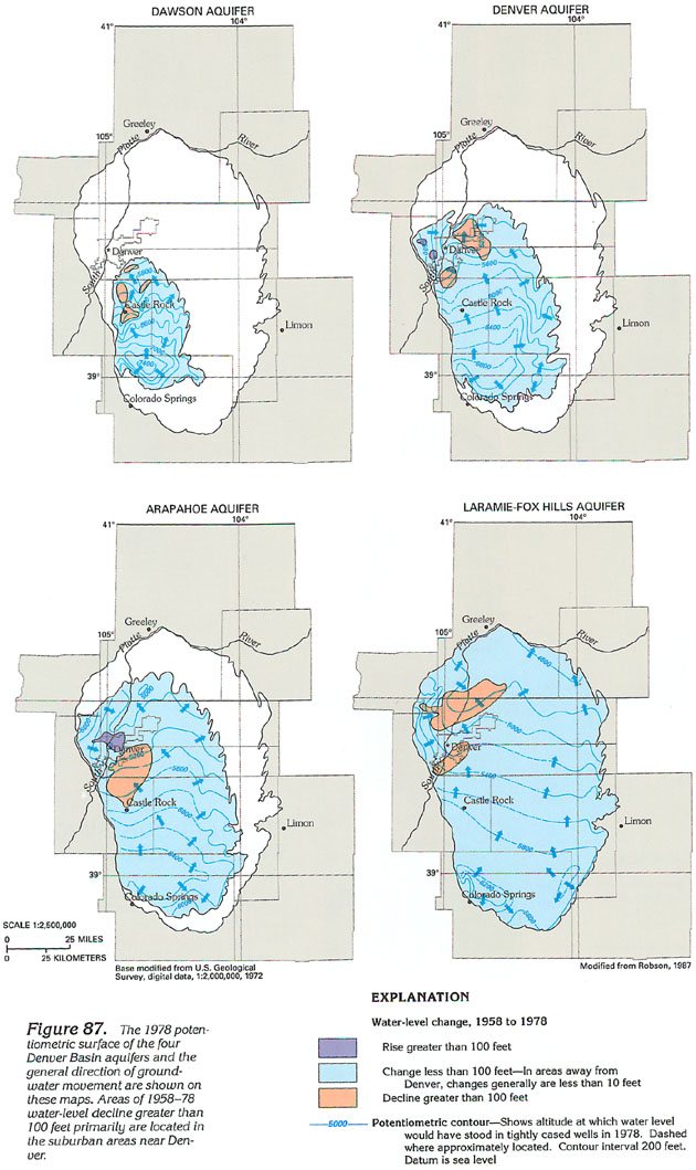
Depth to water in wells completed in the Denver Basin aquifers generally ranges from 0 to 250 feet, but water levels are 500 to 1,300 feet below land surface in parts of the deeper aquifers between Denver and Castle Rock. The large depth to water and the prevalent mudstone and shale layers in the bedrock formations restrict the effect of surface water on water levels in the deep aquifers. As a result, the potentiometric surface in the deeply buried central part of the Laramie-Fox Hills and Arapahoe aquifers is of uniform shape and slopes gently to the north in most areas (fig. 87). The shallow parts of the aquifers are recharged more easily from the land surface, and the potentiometric surface in the Dawson aquifer, for example, is irregular because of recharge from highland areas between stream valleys and discharge to the alluvial aquifers or streams.
Arrows on the potentiometric-surface maps of the Denver Basin aquifers indicate the general direction of ground water movement. Three major features of water movement in the aquifers are the general northward movement of water from recharge areas in the southern part of the basin toward discharge areas in the northern part of the basin, the convergent flow of water toward the discharge area near the South Platte River Valley north of Denver, and the movement of water into depressions in the potentiometric surface caused by groundwater withdrawal from wells near the Denver metropolitan area.
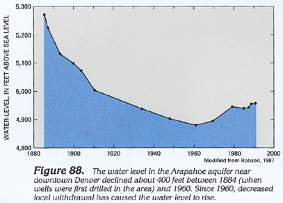
Denver has a long history of water-level decline in wells. Ground-water withdrawal has caused these water-level declines and the resulting decrease in the volume of ground water in storage. Between 1884 and 1980, about 750,000 acre-feet of water was withdrawn from the basin aquifers in the Denver metropolitan area. Although this quantity is only about 0.3 percent of the approximately 270,000,000 acre-feet of recoverable ground water in storage in the aquifers, it is about 30 percent of the 3,800,000 acre-feet of recharge from precipitation for the entire basin that occurred during this period. Thus, in the metropolitan area, withdrawal greatly exceeded the recharge, and water-level declines have exceeded 500 feet in some wells. The only long-term hydrograph of water-level change in the basin indicates that the water level declined about 400 feet in the Arapahoe aquifer near downtown Denver between 1884 and 1960 (fig. 88). Decreased withdrawal has caused a moderate recovery in the water level in this well since 1960. Between 1958 and 1978, water-level declines exceeded 150 feet in parts of the Dawson aquifer, were more than 200 feet in parts of the Denver aquifer, and exceeded 250 feet in parts of the Arapahoe and Laramie-Fox Hills aquifers.
AQUIFER CHARACTERISTICS
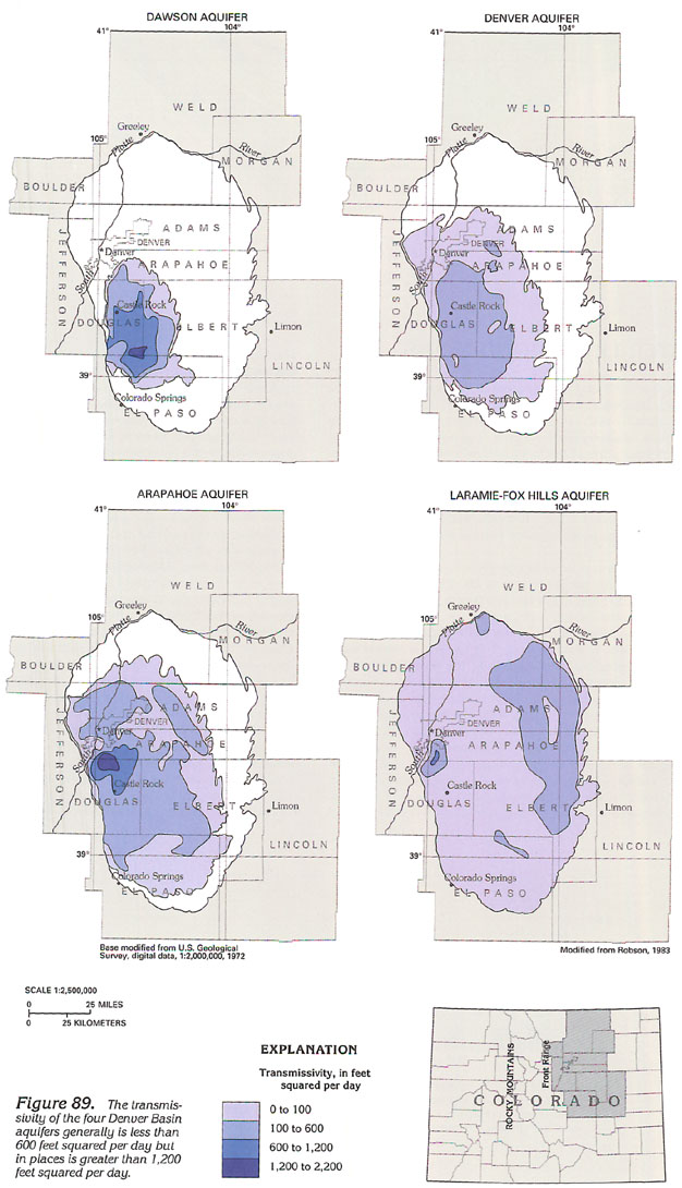
Transmissivity of the Denver Basin aquifers generally ranges from about 10 to 1,000 feet squared per day (fig. 89). In comparison, the transmissivity of the surficial aquifer along the South Platte River Valley generally ranges from about 1,000 to 100,000 feet squared per day. Although the transmissivity of the Denver Basin aquifers is relatively small, these extensive aquifers are major sources of water in a semiarid region.
Large differences in transmissivity are present in each Denver Basin aquifer. The transmissivity of the Laramie-Fox Hills aquifer, for example, is less than 5 feet squared per day near the northwestern margin of the aquifer and is less than 100 feet squared per day over much of the remaining area. However, transmissivity exceeds 600 feet squared per day in an area of south of Denver (fig. 89). A similar zone of relatively large transmissivity is present in the Arapahoe aquifer in about the same locale. These zones of relatively large transmissivity are of benefit to water users in this rapidly developing suburban area.
GROUND-WATER QUALITY
Water in the Denver Basin aquifer system generally has a small dissolved-solids concentration and, in most areas, meets drinking-water regulations established by the U.S. Environmental Protection Agency for public water supplies. The concentration of dissolved solids in ground water ranges from less than 100 milligrams per liter in the Dawson aquifer to about 2,000 milligrams per liter in the Laramie-Fox Hills aquifer. Maps of dissolved-solids concentrations (fig. 90) indicate a general trend of increasing concentrations with distance along ground-water flow paths. In the Dawson aquifer, flow paths generally are short, and water is locally recharged by direct infiltration of precipitation. As a result, this aquifer generally contains water with a small dissolved-solids concentration. Water in the Dawson aquifer is a calcium bicarbonate type, has small sulfate concentrations, and is moderately hard. Some water in the Dawson aquifer moves downward and affects the water quality in the underlying Denver aquifer.
Water in the Denver aquifer generally contains about 100 to 1,000 milligrams per liter of dissolved solids, and is a calcium bicarbonate type near the center of the aquifer and a sodium bicarbonate or sodium sulfate type near the margins of the aquifer. Near the center of the Denver aquifer, the water quality is similar to that in the center of the Dawson aquifer. As the calcium bicarbonate water moves through the Denver and underlying aquifers, the water is naturally softened by cation exchange of calcium ions for sodium ions on the surface of clay minerals in the formations. This cation exchange process increases the dissolved-sodium concentration in the water while decreasing the dissolved-calcium concentration. As a result, water in the Denver Basin aquifers generally is softer at greater depth.
As water moves laterally toward the margins of the aquifers, the quality of the water is degraded by surface recharge that contains dissolved sulfate and other chemical constituents leached from soluble minerals in the overlying soil and rock. The increase in sulfate concentrations is particularly evident near the margins of the Denver, Arapahoe, and Laramie-Fox Hills aquifers.
The processes of ion exchange and dissolution cause water in the Arapahoe aquifer to be somewhat softer and have larger sulfate concentrations than water in the Denver aquifer. Water in the Arapahoe aquifer generally is a sodium bicarbonate or sodium sulfate type. The dissolved-solids concentrations of the water generally range from 200 to 1,400 milligrams per liter (fig. 90).
Water in the Laramie-Fox Hills aquifer also is a sodium bicarbonate or sodium sulfate type and is soft in the central parts of the aquifer and hard to very hard near the margins of the aquifer. The dissolved-solids concentrations of water in this aquifer range from about 200 to 2,000 milligrams per liter; larger concentrations are near the aquifer margins. Reducing (oxygen-deficient) conditions present in some parts of the Laramie-Fox Hills aquifer allow hydrogen sulfide and methane gasses to exist in the aquifer. When these gasses are present in sufficient concentrations, water pumped from the aquifer may effervesce, have a putrid odor, and be of marginal value for many uses.
Dissolved-iron concentrations generally are between 20 and 200 micrograms per liter in water from the Denver Basin aquifers. However, much larger concentrations (ranging from 7,000 to 85,000 micrograms per liter) have been reported in some water samples; these concentrations differ considerably from well to well, apparently in response to the chemical environment of the aquifer near the well. When water that contains large concentrations of dissolved iron is pumped from a well and exposed to oxygen in the air, the dissolved iron reverts to an insoluble form that is visible as a black to reddish-brown precipitate, which clouds and discolors the water and stains porcelain fixtures and laundry.
FRESH GROUND-WATER WITHDRAWALS
The small transmissivity of the Denver Basin aquifers historically has limited large volume, low-profit water uses, such as irrigation of most commercial crops, and has enabled water use that is less constrained by cost. Water withdrawn from the approximately 12,000 wells completed in the Denver Basin aquifers primarily was used for public supply during 1985 (fig. 91). About 53 percent of the fresh ground water withdrawn was used for public supply; about 34 percent was used for agriculture. Total withdrawals from the four aquifers were 36,000 acre-feet.