INTRODUCTION
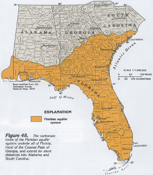
The Floridan aquifer system is one of the most productive aquifers in the world. This aquifer system underlies an area of about 100,000 square miles in southern Alabama, southeastern Georgia, southern South Carolina, and all of Florida (fig. 48). The Floridan aquifer system provides water for several large cities, including Savannah and Brunswick in Georgia; and Jacksonville, Tallahassee, Orlando, and St. Petersburg in Florida. In addition, the aquifer system provides water for hundreds of thousands of people in smaller communities and rural areas. Locally, the Floridan is intensively pumped for industrial and irrigation supplies. During 1985, an average of about 3 billion gallons per day of freshwater was withdrawn from the Floridan for all purposes. Withdrawals during 1988 were somewhat greater. Despite the huge volumes of water that are being withdrawn from the aquifer system, water levels have not declined greatly except locally where pumpage is concentrated or the yield from the system is minimal.
The Floridan is a multiple-use aquifer system. Where it contains freshwater, it is the principal source of water supply. In several places where the aquifer contains saltwater, such as along the southeastern coast of Florida, treated sewage and industrial wastes are injected into it. Near Orlando, Fla., drainage wells are used to divert surface runoff into the Floridan. South of Lake Okeechobee in Florida, the aquifer contains saltwater. Some of this saltwater is withdrawn for cooling purposes and some is withdrawn and converted to freshwater by desalinization plants. Desalinization is especially important in the Florida Keys, which have no other source of freshwater except that which is imported by pipeline.
HYDROGEOLOGIC UNITS
A thick sequence of carbonate rocks (limestone and dolomite) of Tertiary age comprise the Floridan aquifer system. The thickest and most productive formations of the system are the Avon Park Formation and the Ocala Limestone of Eocene age (fig. 49). The Suwannee Limestone (Oligocene age) also is a principal source of water, but it is thinner and much less areally extensive than the Eocene formations. The Tampa Limestone of Miocene age is part of the Floridan in only a few places where it is sufficiently permeable to be an aquifer. Both the Suwannee and the Tampa Limestones are discontinuous. The lower part of the Avon Park Formation, the Oldsmar Formation of early Eocene age, and the upper part of the Cedar Keys Formation of Paleocene age also are included in the Floridan where they are highly permeable. Limestone beds in the lower part of the Hawthorn Formation of Miocene age are considered part of the Floridan by some, but are excluded from it in this Atlas because the permeability of these beds is thought to be minimal. The base of the aquifer system in much of Florida consists of nearly impermeable anhydrite beds in the Cedar Keys Formation. In northern peninsular Florida, the Paleocene and lowermost Eocene rocks contain sand and are much less permeable than the carbonate rocks of the Floridan. Due to the contrast in permeability, these sandy strata form the base of the Floridan aquifer system in this area. Locally, in south-central Georgia and northern peninsular Florida, evaporite minerals have filled the pore spaces in upper Eocene rocks, and these low-permeability beds comprise the base of the system.
Aquifers and Confining Units
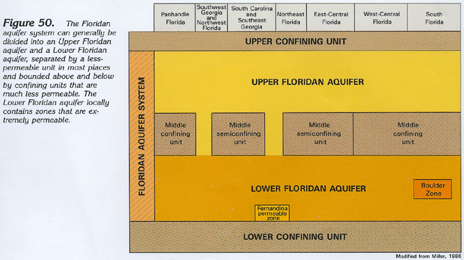
The Floridan aquifer system has been defined on the basis of permeability. In general, the system is at least 10 times more permeable than its bounding upper and lower confining units. The aquifer system is thick and widespread, and the rocks within it generally vary in permeability. In most places, as shown by the idealized layers in figure 50, the system can be divided into the Upper and Lower Floridan aquifers, separated by a less-permeable confining unit.
The geology and hydraulic properties of the Upper Floridan aquifer have been extensively studied, and this is the part of the system described by most reports. The Upper Floridan is highly permeable in most places and includes the Suwannee and Ocala Limestones, and the upper part of the Avon Park Formation. Where the Tampa Limestone is highly permeable, it also is included in the Upper Floridan. In most places, the Upper Floridan aquifer yields sufficient water supplies for most purposes, and there is no need to drill into the deeper Lower Floridan aquifer. The confining unit separating the Upper and Lower Floridan aquifers, informally called the middle confining unit (or semiconfining unit where it allows water to leak through it more easily), is present at different altitudes and consists of different rock types from place to place. The confining unit actually consists of seven separate, discrete units that are idealized into a single layer in figure 50. At some locations, the confining unit consists of clay; at others, it is a very fine-grained (micritic) limestone; at still other places, it is a dolomite with the pore spaces filled with anhydrite. Regardless of rock type, wherever the middle confining unit is present, it restricts the movement of ground water between the Upper and Lower Floridan aquifers.
The geologic characteristics and hydraulic properties of the Lower Floridan aquifer are not as well known as those of the Upper Floridan aquifer because the Lower Floridan is at greater depths, and, therefore, fewer borehole data are available. The Lower Floridan includes the lower part of the Avon Park Formation, the Oldsmar Limestone, and the upper part of the Cedar Keys Formation. Much of the Lower Floridan aquifer contains saltwater. Two important, highly permeable zones are present within the Lower Floridan. One of these is a partly cavernous zone in northeastern Florida and southeastern coastal Georgia, called the Fernandina permeable zone, named after the Fernandina Beach area of Nassau County, Fla. This zone is the source of a considerable volume of fresh to brackish water that moves upward through the middle semiconfining unit and ultimately reaches the Upper Floridan aquifer. The second zone is an extremely permeable cavernous zone in southeastern Florida, known as the Boulder Zone. This name is applied to the zone not because it consists of boulders, but because it is difficult to drill into, having the same rough, shaking, grabbing effect on the drill stem and drilling rig as boulders would. The Boulder Zone contains saltwater and is used as the receiving zone for treated sewage and other wastes disposed through injection wells in the Miami-Fort Lauderdale area. The zone is overlain in most places by a confining unit that prevents upward movement of the injected waste. The cavernous nature of the Fernandina permeable zone and the Boulder Zone was created by the vigorous circulation of ground water through the carbonate rocks in the geologic past, and does not result from the present ground-water flow system.
Thickness
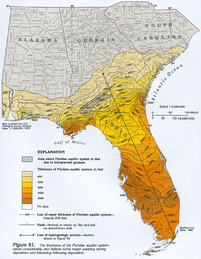
The Floridan aquifer system generally thickens seaward from a thin edge near its northern limit. The variations in thickness of the aquifer system are shown in figure 51. The contours represent the combined thicknesses of the Upper and Lower Floridan aquifers, and the middle confining unit where it is present. Some of the large-scale features on the thickness map are related to geologic structures. For example, the thick areas in Glynn County, Ga., and in Gulf and Franklin Counties, Fla., coincide with two downwarped areas, the Southeast and Southwest Georgia embayments, respectively. In north-central peninsular Florida, the limestone units that comprise the aquifer system are thin over the upwarped Peninsular arch.
A series of small faults bounds downdropped, trough-like crustal blocks (grabens) in southern Georgia and southwestern Alabama (fig. 51). Within these grabens, respectively called the Gulf Trough and Mobile graben, clayey sediments have been downdropped opposite permeable limestone of the Floridan aquifer system. This juxtaposition creates a damming effect that restricts the flow of ground water across the grabens.
VARIATIONS IN THE FLORIDAN AQUIFER SYSTEM
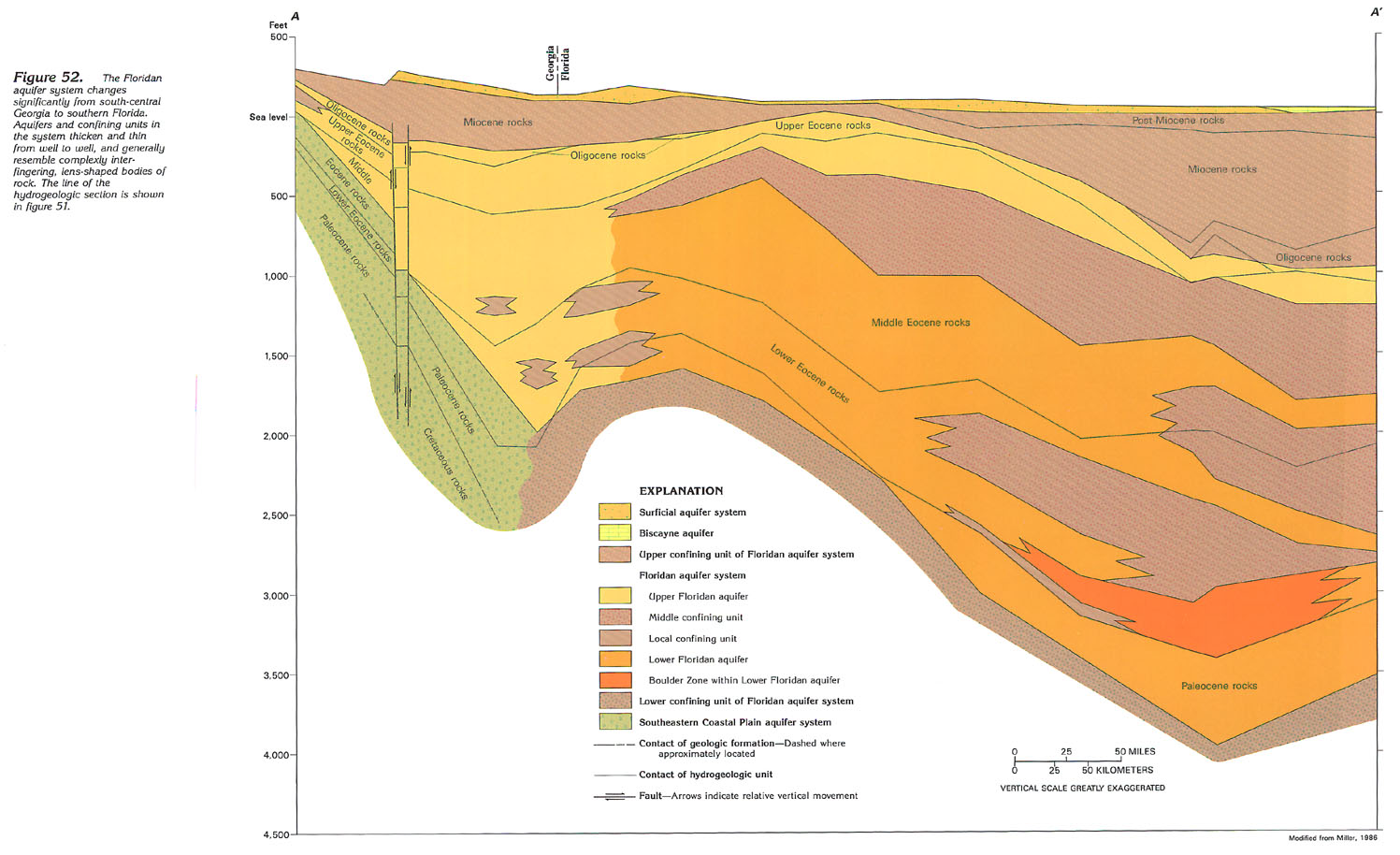
The variations among and complexity of various parts of the Floridan aquifer system along a southeast-trending line from south-central Georgia to southern Florida are shown in figure 52. The most obvious variation is the substantial thickening of the aquifer system to the southeast. The left side of the figure, representing conditions in south-central Georgia, shows that the Floridan is only about 250 feet thick in this area. The right side of the figure, representing southern Florida, shows that the aquifer system is about 3,000 feet thick in places. The break in this gradual thickening, shown between the faults near the left side of the figure, is the graben known as the Gulf Trough. The downward movement of this crustal block produced a depression where a greater than average thickness of the clayey upper confining unit of the Floridan accumulated, thus restricting or partially damming the southward flow of ground water. This damming is reflected on maps of the potentiometric surface of the Floridan.
Another prominent feature shown in figure 52 is the increasing complexity of the Floridan aquifer system toward the southeast. In south-central Georgia, where the system is thin, it contains only scattered, local confining units or none at all. In such areas, the system is hydraulically connected and generally functions as a single water-yielding unit, the Upper Floridan aquifer. Near the Georgia-Florida State line and southeastward, the aquifer system contains regionally-extensive middle confining units that separate it into two aquifers. In places, such as in southern Florida, two or three of these middle confining units are stacked. All of the regional and local confining units within the Floridan consist of carbonate rocks that are less permeable than the main, water-yielding parts of the aquifer system, and all of these confining units retard or partially restrict the movement of ground water in the system.
The Boulder Zone, a deeply-buried, cavernous zone filled with saltwater and used as a receiving zone for injected wastes, is shown near the right side of figure 52 along with the confining bed that overlies it. Also shown in southern Florida is the Biscayne aquifer, which is separated from the Floridan aquifer system by a clayey confining unit that is about 1,000 feet thick in this area.
Near the left side of figure 52, the Southeastern Coastal Plain aquifer system is shown directly underlying the Floridan aquifer system. Throughout much of southern Georgia, these two aquifer systems are in direct contact, and ground water passes freely between them. The permeability of the aquifers in the Southeastern Coastal Plain aquifer system, however, is generally much lower than that of the aquifers in the Floridan aquifer system. The carbonate rocks of the Floridan either had substantial intergranular porosity when they were first formed, or pores in the rocks were enlarged by the dissolving action of circulating, slightly acidic ground water, or both (fig. 53). As these carbonate rocks grade northward into the predominantly clastic rocks of the Southeastern Coastal Plain system, the porosity and permeability of the rocks decreases and they yield less water than the more productive aquifers of the Floridan aquifer system.
Southeastward from about the Georgia-Florida State line, the confining unit that forms the base of the Floridan consists of beds of anhydrite in the Cedar Keys Formation of Paleocene age. These beds consist of calcium sulfate, which, when dissolved, contributes excessive concentrations of sulfate to the ground water. When the sulfate is chemically reduced to hydrogen sulfide, an objectionable, "rotten-egg" taste and odor are produced.
BOULDER ZONE
The deeply buried zone of cavernous permeability, called the Boulder Zone, developed in fractured dolomite in the Lower Floridan aquifer, underlies a 13-county area area in southern Florida (fig. 54). The Boulder Zone is not a single, simple, almost flatlying horizon of caves; rather, as shown by the contours in figure 54, its top is irregular and is as shallow as about 2,000 feet below sea level and as deep as about 3,400 feet below sea level. The zone is thought to represent caverns developed at several different levels and connected by vertical "pipes" or solution tubes similar to a modern cave system. A 90-foot-high cavern reported in the subsurface in southern Florida probably is one of these vertical solution tubes rather than a large cavern.
The permeability of the Boulder Zone is extremely high because of its cavernous nature. This anomalous permeability, which prevents pressure buildup in injection wells, coupled with the fact that the Boulder Zone contains saltwater, makes it an ideal zone for receiving injected wastes. The Boulder Zone has been used for years to store vast quantities of treated sewage injected into it by Miami, Fort Lauderdale, West Palm Beach, and Stuart. Because the salinity and temperature of the water in the Boulder Zone are similar to those of modern seawater, the zone is thought to be connected to the Atlantic Ocean, possibly about 25 miles east of Miami where the sea floor is almost 2,800 feet deep along the Straits of Florida. The Boulder Zone is overlain by 500 to 1,000 feet of low-permeability limestone and dolomite, which retard the upward movement of injected fluids to shallower parts of the Floridan aquifer system that contain fresher although still brackish water.
EFFECTS OF CONFINEMENT
Effects on Dissolution
The carbonate rocks of the Floridan aquifer system are readily dissolved where they are exposed at land surface or are overlain by only a thin layer of confining material. Precipitation absorbs some carbon dioxide from the atmosphere as the precipitation falls and much more carbon dioxide from organic matter in soil as the precipitation percolates downward through the soil, thus forming weak carbonic acid. This acidic water dissolves the limestone and dolomite of the Floridan aquifer system, initially by enlarging pre-existing openings such as pores between grains of limestone or fractures (joints) in the rock. These small solution openings become larger as more of the acidic water moves through the aquifer; eventually the openings may be tens of feet in diameter. The end result of dissolution of carbonate rocks is a type of topography called karst, named for the Karst Plateau of Yugoslavia, that is characterized by caves, sinkholes, and other types of openings caused by dissolution, and by few surface streams.
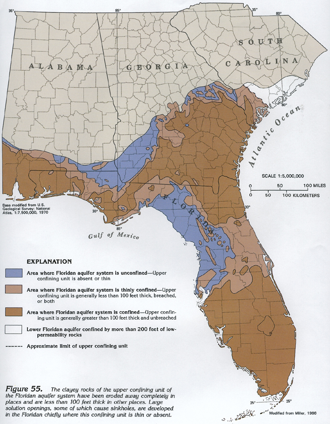
Dissolution of carbonate rocks is greatest where groundwater circulation is most vigorous. Water is able to enter, move through, and discharge from the Floridan aquifer system more readily and rapidly where it is unconfined or where the upper confining unit is thin. Such areas are shown in figure 55. In these unconfined areas, the aquifer is either exposed or, more commonly, is covered by a thin layer of sand or by clayey, residual soil. In adjacent areas, the Floridan is confined, but the upper confining unit is less than 100 feet thick (fig. 55). In these areas, sinkholes that locally breach the confining unit and allow precipitation to move quickly downward into the aquifer are common. Where the confining unit is thick and unbreached (fig. 55), there has been little dissolution of the aquifer system except in deeply buried zones of paleokarst, such as the Fernandina permeable zone of southeastern Georgia and northeastern Florida, and the Boulder Zone of southern Florida. However, these deeply buried zones chiefly formed in the geologic past, when the rocks comprising the zones were at or near the land surface, and are not the result of the modern ground-water flow system.
Effects on Transmissivity
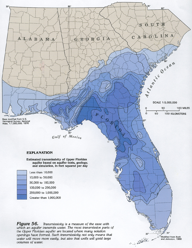
The large-scale solution porosity that develops as a result of dissolution of the carbonate rocks in the Floridan aquifer system creates large conduits in some places that store and transmit ground water. These conduits, which include caves, solution channels, and sinkholes, are like large-diameter pipes or channels in that they allow tremendous volumes of water to pass quickly through the aquifer with little resistance to flow. Transmissivity, or the capacity of an aquifer to transmit water, is one way of measuring the relative ease with which ground water moves. The greater the transmissivity, the more readily water is able to move through the aquifer.
The distribution of transmissivity values in the Upper Floridan aquifer, the best-known part of the Floridan aquifer system, is shown in figure 56. All of the area having a transmissivity greater than 1,000,000 feet squared per day and most of the area having transmissivity from 250,000 to 1,000,000 feet squared per day are where the upper confining unit of the Floridan aquifer system is less than 100 feet thick, or is absent (compare figs. 55 and 56). These areas are where large solution openings developed in the carbonate rocks allow water to be conveyed through the aquifer rapidly. Where the upper confining unit is greater than 100 feet thick, transmissivity values generally are lower and flow is not so rapid. Where the aquifer is more thickly confined and less affected by dissolution, variations in the original porosity of the aquifer chiefly are responsible for the changes in transmissivity. The lower transmissivity values (less than 50,000 feet squared per day) shown in figure 56 mark places either where the upper confining unit is thick (southern Florida) or where the aquifer system is thin or its porosity and permeability are low, or both (areas near the updip limit of the aquifer system).
Effects on Springs
Springs are places where ground water discharges through natural openings in the ground. Springs may vary greatly in the volume of water they discharge; some springs are small enough to be expressed only as seeps where water oozes slowly from the aquifer, whereas others are large enough to form the headwaters of large rivers. The water discharged by a spring may be from an aquifer that is unconfined (water-table conditions) or confined (artesian conditions). Springs issuing from an unconfined aquifer tend to have a small, extremely variable flow and are directly and quickly affected by variations in precipitation. These springs may cease flowing during periods of less than normal precipitation. In contrast, springs issuing from a confined aquifer have a more constant flow because their flow is supplied by a much greater replenishment area. Accordingly, such springs tend to be unaffected by variations in precipitation unless there is prolonged drought. Springs are common in areas of karst topography. Spring flow is controlled by the size of the replenishment area, the difference in altitude between the spring opening or openings and the water level in the aquifer, and the size of the opening or openings through which the springs issue. Factors that have lesser effects on spring flow include atmospheric-pressure changes, earth and oceanic tides, and pumping of wells located near springs.
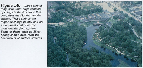
Florida has 27 first-magnitude springs (springs with a flow of 100 cubic feet per second or more) out of a total of 78 in the entire Nation. The location of these springs is shown in figure 57. All of them issue from the Upper Floridan aquifer, and practically all of them are located in areas where the upper confining unit of the Floridan aquifer system either is less than 100 feet thick or is absent. The distribution of large springs discharging from the Floridan aquifer system, like the areas of greatest transmissivity within the aquifer system, is the direct result of dissolution of carbonate rocks, which results in the development of large conduits. Many of these caverns channel the ground water to the point where they are exposed at land surface and become the orifices of major springs (fig. 58).
GROUND-WATER FLOW
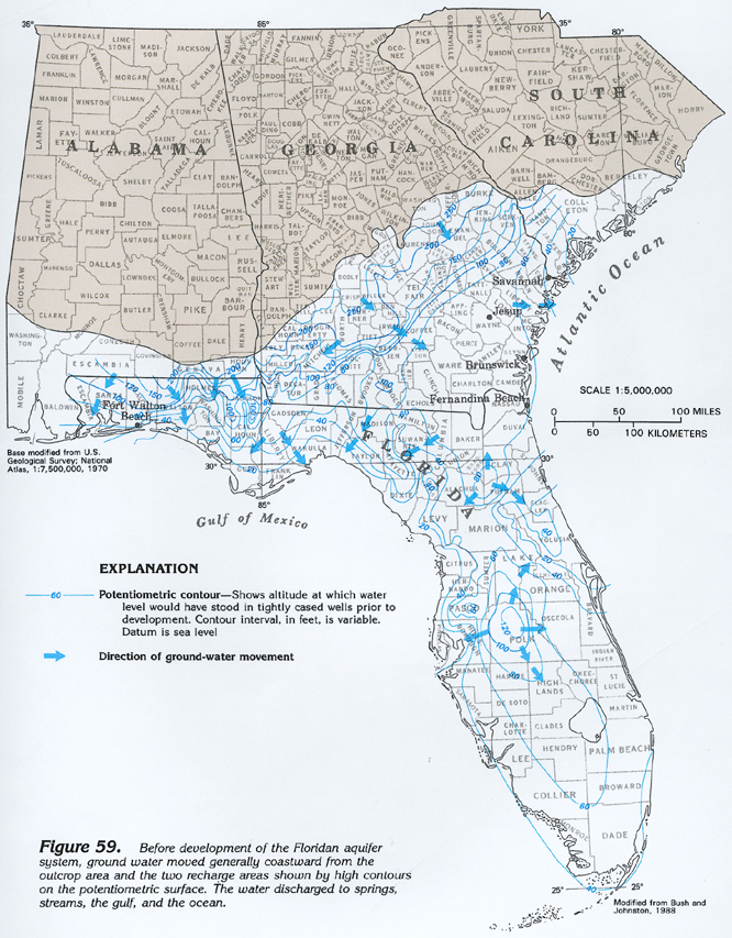
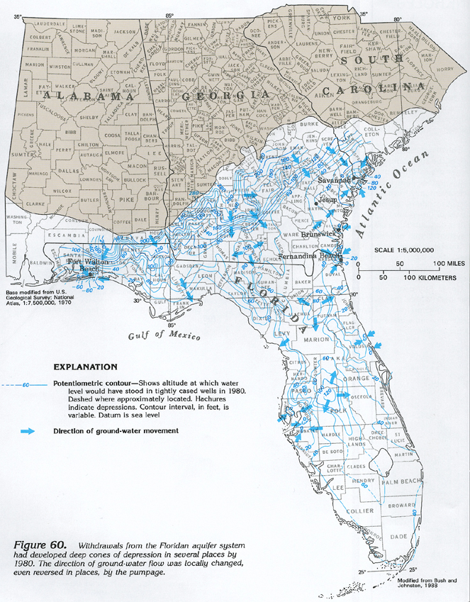
The existence of a regional ground-water flow system in the Floridan aquifer system was first recognized in peninsular Florida in the 1930's and, by the 1940's, this system was known to extend into Georgia and South Carolina. The major features of this ground-water flow system can be illustrated by a map of the potentiometric surface of the Upper Floridan aquifer. The contours shown in figure 59 represent the altitude and configuration of the potentiometric surface of the Upper Floridan aquifer before development (that is, the condition before substantial withdrawals from the aquifer began). The altitude and configuration of the potentiometric surface in 1980, when withdrawals had changed the configuration of the surface considerably, is shown in figure 60. In both figures, the contours represent lines of equal altitude of the potentiometric surface or water level. The arrows superimposed on the maps show the direction of ground-water movement, which generally is perpendicular to the contours.
Water in the Upper Floridan aquifer moves from high to low areas on the potentiometric surface. The highest areas on the Upper Floridan's potentiometric surface are located: (1) in a band where the aquifer is exposed at the land surface near its landward, updip limit and (2) in an area in central peninsular Florida (figs. 59 and 60). Water moves coastward from the outcrop area of the aquifer and outward in all directions from the potentiometric high in central Florida. Although recharge to the aquifer takes place throughout more than one-half of its area, recharge tends to be concentrated in outcrop areas and at potentiometric highs. Rates of recharge vary from less than 1 inch to more than 20 inches per year, depending on local geologic and hydrologic conditions. For example, in Lowndes County in south-central Georgia, the aquifer is hydraulically connected to the Withlacoochee River through swallow holes (sinkholes that develop in a bed of a stream) in the streambed and captures much or all of the streamflow during dry seasons. Recharge here is estimated to be between 10 and 20 inches per year. In contrast, little recharge (an estimated 1 to 5 inches per year) takes place at the potentiometric high in central peninsular Florida.
Before development, nearly 90 percent of the discharge from the Floridan aquifer system was to springs and streams. Upward leakage across confining units, especially in coastal areas, accounted for slightly more than 10 percent of the discharge. Discharge to offshore springs was common on both the gulf and ocean sides of the northern part of peninsular Florida where onshore hydraulic heads were 10 feet or less. Contours that extend offshore from coastal Georgia and adjacent northeastern Florida are based on freshwater heads measured during recent test drilling.
The degree of confinement of the Floridan aquifer system is the characteristic that most greatly affects the distribution of recharge and discharge, and is reflected in the character of the potentiometric surface. Where the system is unconfined or the upper confining unit is thin, there is substantial hydraulic connection between the aquifer and surface drainage. In such areas, the potentiometric surface is irregular, complex, and has many closed highs and lows. Contours are commonly distorted where they cross surface streams or where there are groups of springs. In areas of thick confinement, the aquifer is not affected by surface streams because of the intervening confining unit. Smooth contours are, accordingly, associated with confined conditions. Examples of such places are southeastern Georgia and South Carolina, western panhandle Florida, and southern peninsular Florida.
The band of closely spaced contours trending northeast across south-central Georgia (fig. 59) is located just upgradient from the Gulf Trough, a graben filled with a greater than average thickness of the clayey upper confining unit. Faults bounding this graben extend through the Floridan aquifer system and have allowed confining-unit material to be downdropped opposite the aquifer, thus impeding ground-water flow. This damming effect is represented by the closely spaced potentiometric contours.
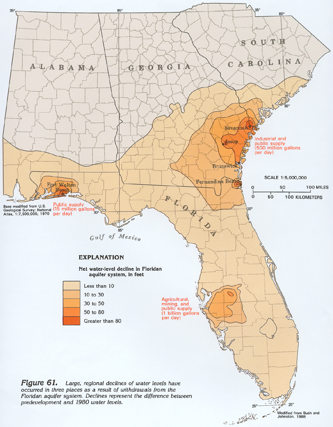
The effect of ground-water withdrawals on the potentiometric surface of the Upper Floridan aquifer is illustrated by a map of that surface as it existed in 1980 (fig. 60). The major features of the potentiometric surface are the same as those of the predevelopment surface. That is, the direction of flow in South Carolina and Georgia was still east or southeast from outcrop areas to the Atlantic Ocean and Florida. In peninsular Florida, the general flow direction was still toward the gulf and ocean. However, the effect of withdrawals is shown by deep cones of depression at Savannah, Jesup, and Brunswick, Ga., and at Fernandina Beach and Fort Walton Beach, Fla. Also, hydraulic heads have been lowered 30 feet or more throughout a five-county area southeast of Tampa Bay on the west coast of Florida as a result of withdrawals for irrigation and industrial needs. Regional declines of more than 10 feet have occurred in three broad areas surrounding pumping centers (fig. 61): (1) southeastern Georgia and adjacent parts of northeastern Florida and southern South Carolina; (2) west-central peninsular Florida; and (3) western panhandle Florida. Predevelopment potentiometric gradients have been locally reversed in some coastal areas, creating the potential for encroachment of saltwater from the gulf or ocean or from deep parts of the aquifer that contain saltwater. However, saltwater encroachment was limited to a few localized areas as of 1986.
The major characteristics of the predevelopment flow system have not been greatly altered by ground-water development. The dominant form of discharge remains springflow and discharge to streams. The withdrawal of more than 3 billion gallons per day of freshwater during the early 1980's accounts for less than 20 percent of the total discharge of the Floridan aquifer system.
SINKHOLES
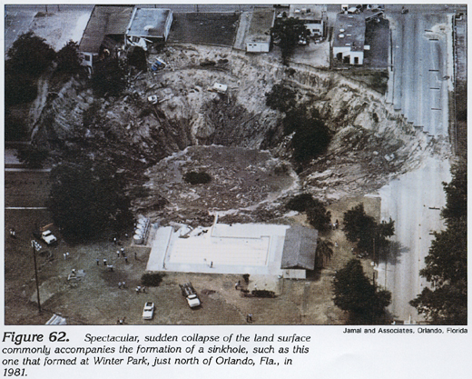
Sinkholes are closed depressions in the land surface formed by dissolution of near-surface rocks or by the collapse of the roofs of underground channels and caverns. Sinkholes are a natural, common geologic feature in places underlain by soluble rocks such as the limestone and dolomite that form the Floridan aquifer system. Under natural conditions, sinkholes form slowly and expand gradually. However, activities, such as dredging, constructing reservoirs, diverting surface water, and pumping ground water can accelerate the rate of sinkhole expansion, resulting in the abrupt formation of collapse-type sinkholes, some of which are spectacular (fig. 62).
The dissolution of carbonate rocks by acidic water is the cause of the subsidence that creates all sinkholes. The water enlarges pre-existing openings ranging from pore spaces between limestone particles to fractures in the rock. The enlarged spaces eventually form a network of caves, pipes, and other types of conduits, all of which collect and channel large volumes of ground water. In the Floridan aquifer system, the greatest dissolution occurs where the upper confining unit of the system is thin or absent.
Sinkholes have important effects on both surface and ground water. Lakes commonly occupy the depressions created by sinkhole collapse. Streams, such as the Withlacoochee River near Valdosta, Ga., lose their entire flow at low-flow stages to the Upper Floridan aquifer through swallow holes in the streambed. Where they are not plugged, sinkholes form a direct connection from the land surface to the Upper Floridan aquifer, allowing surface runoff to move directly and quickly into the aquifer.
Some sinkholes form by slow, gradual subsidence of the land surface in response to dissolution of limestone (fig. 63). These gradually subsiding sinkholes are usually shallow and bowl-shaped, and form in places where the limestone is either: (1) exposed at the land surface or thinly covered or (2) covered by a layer of unconsolidated sand that slumps downward to fill the sinkhole as it forms. In the latter case, infilling of the sinkhole keeps pace with dissolution of the limestone. Gradually subsiding sinkholes commonly form where slow dissolution takes place, mostly along joints in the limestone. These sinkholes tend to form naturally and are not greatly affected by human activities.
Collapse sinkholes, such as the one shown in figure 64, form suddenly by the collapse of the roof of a large solution cavity Such large cavities commonly form where ground water circulation is vigorous, thus accelerating the dissolution of the limestone. As the cavity expands laterally, its roof gradually flakes off under the effect of gravity. Continued dissolution and spalling of the cavity roof proceed until the roof suddenly collapses under the weight of the overlying material, and a steep-sided, circular sinkhole forms. Collapse sinkholes form either in places where the cavity roof consists entirely of limestone, or where clay forms a bridge over the cavity (fig. 64); they are the type of sinkhole that usually forms in response to human activities. Additional loading of the land surface by construction of surface-water impoundments or buildings, abrupt decline of the potentiometric surface of the Upper Floridan aquifer in areas of substantial pumpage or harmonic loads produced by the vibratory action of passing trains or heavy construction equipment have all been known to trigger sinkhole collapse.
GROUND-WATER DEVELOPMENT
Ground-water development of the Floridan aquifer system began in the 1880's when Savannah, Ga., and Jacksonville, Fla., first constructed wells for municipal supply. By the early 1900's, several other cities, including Brunswick, Ga., and Daytona Beach, Fernandina Beach, Fort Meyers, Orlando, St. Petersburg, Tallahassee, and Tampa, Fla., were obtaining water supplies from the Floridan. Many of these early wells flowed because hydraulic heads initially were high. However, increased use soon caused the hydraulic head in the Upper Floridan aquifer to decline until installation of pumps and deepening of supply wells became necessary. Starting in the 1930's, industrial withdrawals from the Floridan became an important factor as pulp- and paper-processing plants in southeastern Georgia and northeastern Florida, and phosphate mining and citrus-processing operations in west-central Florida, began to withdraw large volumes of ground water.
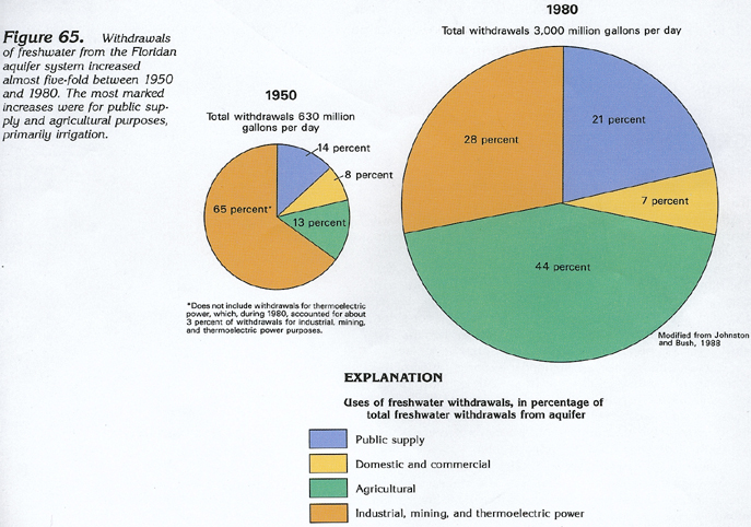
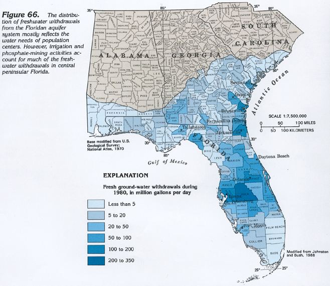
By 1950, withdrawals of freshwater from the Floridan for all purposes totaled about 630 million gallons per day (fig. 65); by 1980, nearly five times this volume, or about 3 billion gallons per day, was being pumped. The dominant factors causing this increase were the expansion of agriculture, industry, and mining, and the increased demand for public water supplies, especially in Florida where the population served by the Floridan aquifer system nearly tripled during this 30-year period. Significant changes in the use of water from the Floridan occurred between 1950 and 1980. The major changes have been in the percentage of withdrawal used for agricultural purposes, primarily irrigation, which more than tripled, and the percentage withdrawn for self-supplied industrial, mining, and thermoelectric power uses, which decreased by more than one-half. The majority of the withdrawals in the latter category are for industrial use; withdrawals for mining and thermoelectric power uses account for only about 3 percent of the combined pumpage. The percentage withdrawn for domestic and commercial uses remained practically the same, but that for public supply increased by one-third, directly reflecting trends in population increases.
The regional distribution of estimated withdrawals of freshwater from the Floridan aquifer system, by county, for all uses except domestic and commercial, is shown in figure 66. More water is withdrawn in central Florida than elsewhere, primarily for citrus irrigation and processing, and phosphate-mining activities. Almost 30 percent of the total pumpage is withdrawn in a five-county area-Hillsborough, Orange, Pasco, Pinellas, and Polk Counties. Polk County uses the most ground water; about 310 million gallons per day was withdrawn during 1980. Orange County was second in ground-water use, with an estimated 200 million gallons per day being withdrawn. Pumpage is primarily for irrigation in most of those counties in central Florida where 20 to 100 million gallons per day are withdrawn (fig. 66). The large withdrawals (50 to 100 million gallons per day) in Taylor County in the easternmost part of panhandle Florida are primarily for industrial use (pulp and paper production).
Substantial volumes of fresh ground water are withdrawn in several coastal counties in northeastern Florida and coastal Georgia (fig. 66). During 1980, public supply and industrial pumpage accounted for about 160 million gallons per day in the Duval-Nassau County, Fla., area (Jacksonville and Fernandina Beach); about 100 million gallons per day in Glynn County, Ga., ( Brunswick); and about 75 million gallons per day in both Wayne County (Jesup) and Chatham County (Savannah), Ga. In Georgia, the greatest withdrawals for agricultural purposes, primarily irrigation, during 1980 were in a 15-county area known as the Dougherty Plain in southwestern Georgia, where a total of about 210 million gallons per day was withdrawn.
Uncontrolled flowing wells in many counties in central and southern Florida are a commonly overlooked but important source of discharge from the Floridan aquifer system. Where hydraulic heads are high, some of these wells discharge at land surface; others discharge into shallow zones in the Floridan or overlying aquifers through deteriorated well casings or open boreholes. In 1978, there were as many as 15,000 uncontrolled flowing wells in Florida that discharged an estimated 790 million gallons per day-almost one-third as much as was pumped from the aquifer system during 1980. Many of these wells were subsequently located and plugged under an ongoing program conducted by State and local governmental agencies.
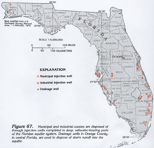
INJECTION WELLS
Parts of the Lower Floridan aquifer that contain saltwater are locally used as receiving zones for industrial and municipal wastes disposed of through injection wells in Florida. The location of injection-well sites in Florida that were operating as of January 1988 is shown in figure 67. About 208 million gallons per day of wastes are injected into these wells; about 97 percent of this volume is municipal waste. Some of the wells, such as those in Polk County, Fla., are used to inject wastes into permeable rocks below the Floridan aquifer system because the entire Floridan contains freshwater in Polk County. The majority of injection wells, however, are completed in the deeper parts of the Floridan that contain saltwater.
In central Florida, particularly in the Orlando area (Orange County), drainage wells have been used since the early 1900's to dispose of storm runoff into the Upper Floridan aquifer (fig. 67). Public water-supply wells in the Orlando area, accordingly, are drilled into the Lower Floridan aquifer, which is separated from the Upper Floridan aquifer by a confining unit. There is no evidence to date that the drainage wells have contaminated the Lower Floridan aquifer to any great extent, even though they provide an estimated 30 to 50 million gallons per day of recharge to the system.
GROUND-WATER QUALITY
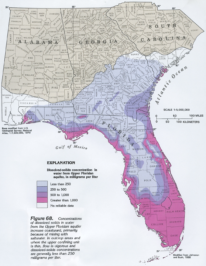
Dissolved-solids concentrations (the sum of all cations and anions in solution) of water in the Floridan aquifer system are related to: (1) the ground-water flow system, and (2) the proximity to saltwater. In places where the aquifer system is unconfined or thinly confined, ground-water flow is vigorous. Large volumes of water move quickly in and out of the aquifer system, and dissolved-solids concentrations are minimal. Water that travels down longer flowpaths, and, thus, dissolves more limestone and possibly sulfate minerals, such as gypsum, has greater dissolved-solids concentrations. Dissolved-solids concentrations in the Upper Floridan aquifer are shown in figure 68. Near the east and west coasts of Florida, and locally in eastern South Carolina and adjacent areas of coastal Georgia, large dissolved-solids concentrations are due to the mixing of fresh ground water with deeper saltwater that migrates into the aquifer from the ocean. In western panhandle Florida and in the southern one-third of that State, large concentrations of dissolved solids result from the ground water mixing with residual saltwater that a sluggish flow system has left unflushed from the aquifer. The band of large dissolved-solids concentrations along the St. Johns River in east-central Florida likewise reflects unflushed, residual saltwater.
The most common cations in water from the Upper Floridan aquifer are calcium, magnesium, and sodium; the most common anions are bicarbonate, chloride, and sulfate. All of these ions are present either in the minerals of the aquifer or in unflushed saltwater within the aquifer. In general, water in the Lower Floridan aquifer is chemically similar to that of the Upper Floridan aquifer, except for dissolved-solids concentrations. There are more dissolved solids in the water in the Lower Floridan aquifer because this water has followed longer flowpaths and, accordingly, has had more time to dissolve aquifer minerals.