GROUND WATER ATLAS of the UNITED STATES
Idaho, Oregon, Washington
HA 730-H
Snake River Plain regional aquifer system
There are two different files for each illustration
- A 90 ppi JPEG file, suitable for screen viewing is accessed
through the thumbnail image.
- A tiff file is accessed through the "tiff file"
link. All files are Adobe Photoshop. These files have been compressed
with GNU's gzip utility. If your web browser defaults to a screen
display of the file, turn on the "Load to local disk"
option before downloading. Download and process these tiff files
as ascii, not binary.
Figure 52 Map showing location of the
Snake River Plain regional aquifer system (244K)
 downloadable
tiff file H052.tif.gz (1.9MB
compressed)
downloadable
tiff file H052.tif.gz (1.9MB
compressed)
Figure 53 Map showing geology of the Snake
River Plain regional aquifer system (144K)
 downloadable tiff
file H053.tif.gz (3.2MB compressed)
downloadable tiff
file H053.tif.gz (3.2MB compressed)
Figure 54 Map showing thickness of Pliocene
and younger basaltic rocks (228K)
 downloadable
tiff file H054.tif.gz (1.9MB
compressed)
downloadable
tiff file H054.tif.gz (1.9MB
compressed)
Figure 55 Map showing saturated
thickness of Pliocene and younger basaltic rocks (224K)
 downloadable
tiff file H055.eps.gz (1.9MB
compressed)
downloadable
tiff file H055.eps.gz (1.9MB
compressed)
Figure 56 Map showing thickness of unconsolidated
deposits (232K)
 downloadable
tiff file H056.tif.gz (1.8MB
compressed)
downloadable
tiff file H056.tif.gz (1.8MB
compressed)
Figure 57 Map showing depth to uppermost
volcanic rock unit (128K)
 downloadable tiff
file H057.tif.gz (3.3MB compressed)
downloadable tiff
file H057.tif.gz (3.3MB compressed)
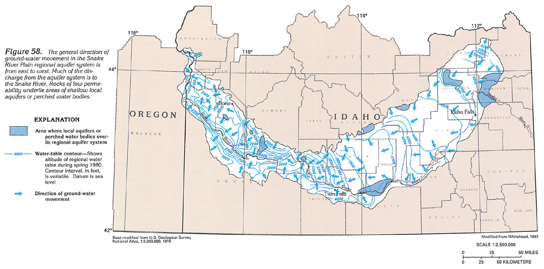
Figure 58
Map showing ground-water movement in the Snake River Plain
regional aquifer system (164K)
 downloadable tiff
file H058.tif.gz (3.2MB compressed)
downloadable tiff
file H058.tif.gz (3.2MB compressed)
Eastern Plain
Figure 59 Cross-section of eastern Snake River Plain
regional aquifer system (376K)
 downloadable
tiff file H059.tif.gz (2.7MB
compressed)
downloadable
tiff file H059.tif.gz (2.7MB
compressed)
Figure 60 Cross-section near the margins
of the Snake River Plain regional aquifer system (344K)
 downloadable
tiff file H060.tif.gz (3MB
compressed)
downloadable
tiff file H060.tif.gz (3MB
compressed)
Figure 61 Photographs showing surficial
features of characteristic types of aquifer openings (280K)
 downloadable
tiff file H061.tif.gz (2.2MB
compressed)
downloadable
tiff file H061.tif.gz (2.2MB
compressed)
Figure 62 Photograph showing springs issuing
from wall of the Snake River Canyon (204K)
 downloadable
tiff file H062.tif.gz (1.4MB
compressed)
downloadable
tiff file H062.tif.gz (1.4MB
compressed)
Figure 63 Cross-section showing basaltic
lava flows (264K)
 downloadable
tiff file H063.tif.gz (2MB
compressed)
downloadable
tiff file H063.tif.gz (2MB
compressed)
Figure 64 Map showing locations where physical
aspects and cultural practices affecting the ground-water flow
in the eastern plain are described in text (300K)
 downloadable
tiff file H064.tif.gz (2.7MB
compressed)
downloadable
tiff file H064.tif.gz (2.7MB
compressed)
Table 2 Table showing ground-water conditions
in the eastern Snake River Plain in Idaho (340K)
 downloadable
tiff file Htab2.tif.gz
(2.3MB compressed)
downloadable
tiff file Htab2.tif.gz
(2.3MB compressed)
Western Plain
Figure 65 Cross-section showing unconsolidated-deposit
aquifers (324K)
 downloadable
tiff file H065.tif.gz (2.2MB
compressed)
downloadable
tiff file H065.tif.gz (2.2MB
compressed)
Figure 66 Map showing percentage of sand
and gravel in the unconsolidated-deposit aquifers (284K)
 downloadable
tiff file H066.tif.gz (2.4MB
compressed)
downloadable
tiff file H066.tif.gz (2.4MB
compressed)
Figure 67 Generalized hydrogeologic section
in the western Snake River Plain (200K)
 downloadable
tiff file H067.tif.gz (1.3MB
compressed)
downloadable
tiff file H067.tif.gz (1.3MB
compressed)
Figure 68 Hydrogeologic section showing
diagram of perched water body (168K)
 downloadable
tiff file H068.tif.gz (1.2MB
compressed)
downloadable
tiff file H068.tif.gz (1.2MB
compressed)
Table 3 Table showing ground-water conditions
in the western Snake River Basin (280K)
 downloadable
tiff file Htab3.tif.gz
(1.9MB compressed)
downloadable
tiff file Htab3.tif.gz
(1.9MB compressed)
Return to Snake River Plain regional
aquifer system text
Return to HA 730-H table of contents
Return to Ground Water Atlas home page

 downloadable tiff
file H053.tif.gz (3.2MB compressed)
downloadable tiff
file H053.tif.gz (3.2MB compressed) 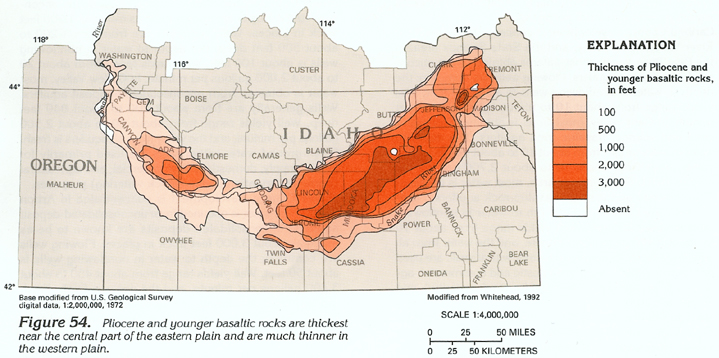 downloadable
tiff file H054.tif.gz (1.9MB
compressed)
downloadable
tiff file H054.tif.gz (1.9MB
compressed) 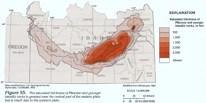 downloadable
tiff file H055.eps.gz (1.9MB
compressed)
downloadable
tiff file H055.eps.gz (1.9MB
compressed) 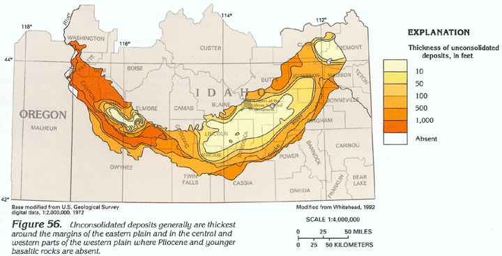 downloadable
tiff file H056.tif.gz (1.8MB
compressed)
downloadable
tiff file H056.tif.gz (1.8MB
compressed) 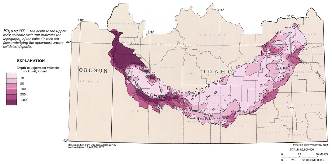 downloadable tiff
file H057.tif.gz (3.3MB compressed)
downloadable tiff
file H057.tif.gz (3.3MB compressed)
 downloadable tiff
file H058.tif.gz (3.2MB compressed)
downloadable tiff
file H058.tif.gz (3.2MB compressed) 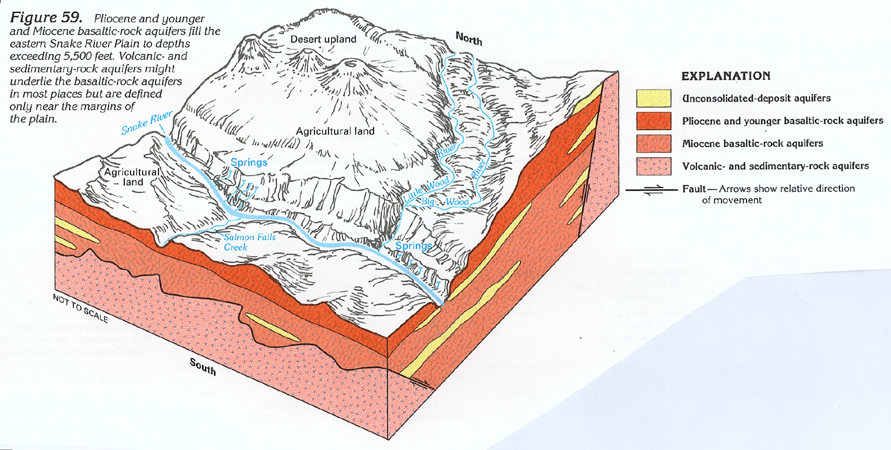 downloadable
tiff file H059.tif.gz (2.7MB
compressed)
downloadable
tiff file H059.tif.gz (2.7MB
compressed)  downloadable
tiff file H060.tif.gz (3MB
compressed)
downloadable
tiff file H060.tif.gz (3MB
compressed) 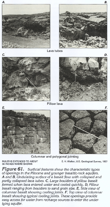 downloadable
tiff file H061.tif.gz (2.2MB
compressed)
downloadable
tiff file H061.tif.gz (2.2MB
compressed) 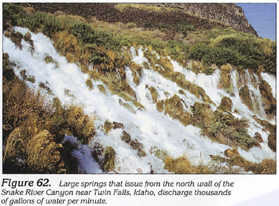 downloadable
tiff file H062.tif.gz (1.4MB
compressed)
downloadable
tiff file H062.tif.gz (1.4MB
compressed)  downloadable
tiff file H063.tif.gz (2MB
compressed)
downloadable
tiff file H063.tif.gz (2MB
compressed) 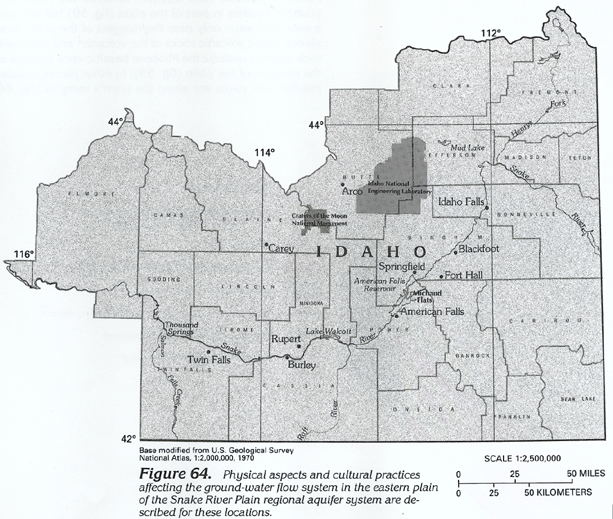 downloadable
tiff file H064.tif.gz (2.7MB
compressed)
downloadable
tiff file H064.tif.gz (2.7MB
compressed) 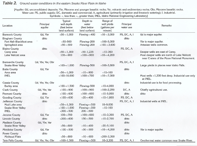 downloadable
tiff file Htab2.tif.gz
(2.3MB compressed)
downloadable
tiff file Htab2.tif.gz
(2.3MB compressed)  downloadable
tiff file H065.tif.gz (2.2MB
compressed)
downloadable
tiff file H065.tif.gz (2.2MB
compressed) 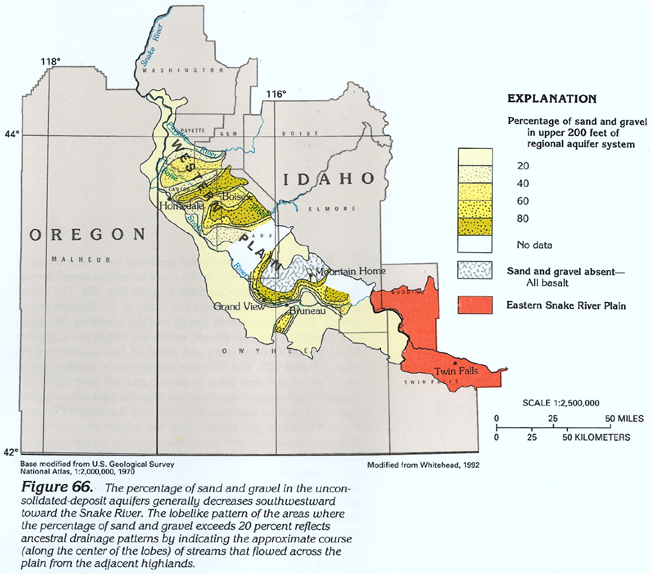 downloadable
tiff file H066.tif.gz (2.4MB
compressed)
downloadable
tiff file H066.tif.gz (2.4MB
compressed) 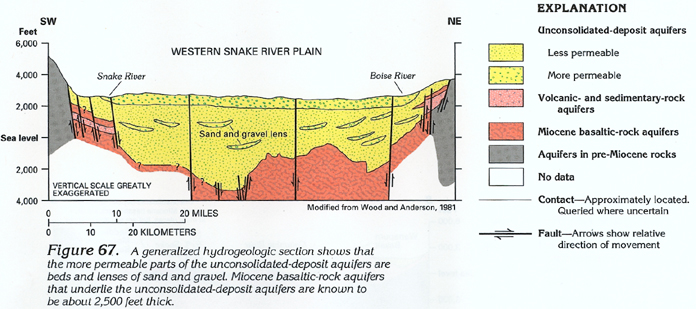 downloadable
tiff file H067.tif.gz (1.3MB
compressed)
downloadable
tiff file H067.tif.gz (1.3MB
compressed) 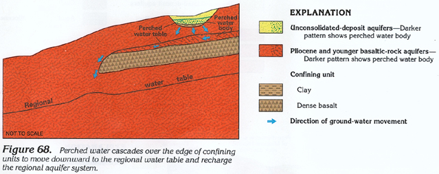 downloadable
tiff file H068.tif.gz (1.2MB
compressed)
downloadable
tiff file H068.tif.gz (1.2MB
compressed) 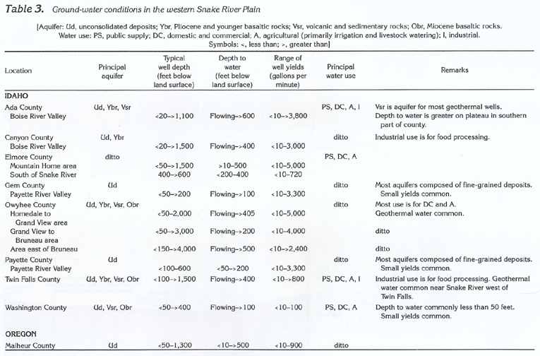 downloadable
tiff file Htab3.tif.gz
(1.9MB compressed)
downloadable
tiff file Htab3.tif.gz
(1.9MB compressed)