INTRODUCTION
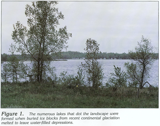
Segment 9, which consists of Minnesota, Iowa, Wisconsin, and Michigan, abuts the Canadian border in the upper Midwest and lies adjacent to or surrounds four of the Great Lakes-Superior, Michigan, Huron, and Erie. Thousands of small to large lakes similar to the one shown in figure 1 dot the landscape, which is drained by numerous rivers and streams tributary primarily to the Mississippi River in the west and to the Great Lakes-St. Lawrence River system in the east. These abundant surface-water sources represent an ample supply of water to large users, such as the cities of Milwaukee, Wis., and Detroit, Mich. However, water stored in unconsolidated and consolidated sedimentary-rock aquifers that underlie the four States also is in abundant supply and is an economical source that can be used for nearly any purpose, usually with little or no treatment. In more than 95 percent of the four-State area, these aquifers supply water to a broad spectrum of consumers-from individual households to cities, such as St. Paul, Minn., Madison, Wis., and Lansing, Mich. These aquifers are the subject of this chapter. The geology and the hydrology of each of the principal aquifers are illustrated and discussed insofar as information was available from the literature. Hydrogeology, ground-water flow, availability and quality of water, and freshwater withdrawals from each of the aquifers are the principal subjects of discussion.
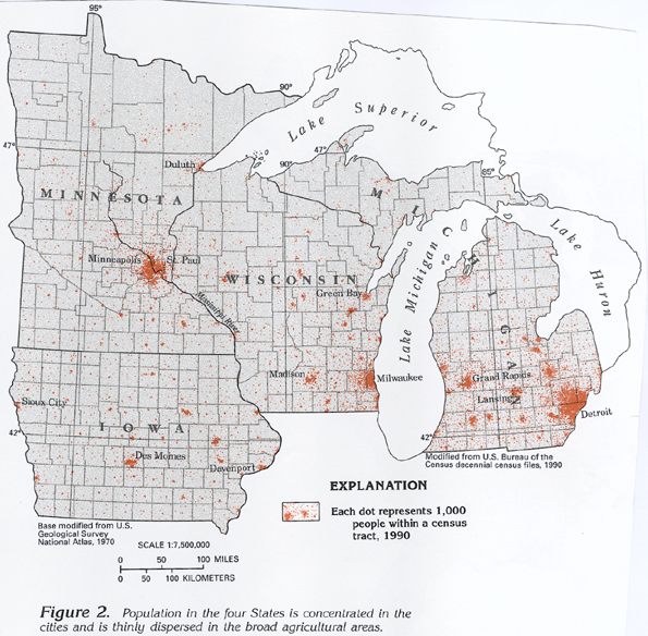
Population in the four States is concentrated in the cities and is thinly dispersed in the broad agricultural areas of the States (fig. 2). Minneapolis-St. Paul, Minn., Des Moines, Iowa, Milwaukee and Madison, Wis., and Detroit and Lansing, Mich., are a few of the principal cities. Many of these cities and other large population centers represent areas of concentrated ground-water withdrawals.
Precipitation is the source of all water in Segment 9. Average annual precipitation ranges from about 20 to 40 inches across the segment and generally increases from northwest to southeast (fig. 3). Precipitation is least in the northwestern part of the segment because of the orographic effect of the Rocky Mountains, which are hundreds of miles to the west. Annual precipitation in excess of 36 inches that falls south and east of Lakes Superior and Michigan (fig. 3) is a result of the prevailing westerly winds that evaporate moisture from the lakes; this moisture subsequently condenses and falls as precipitation over the land.
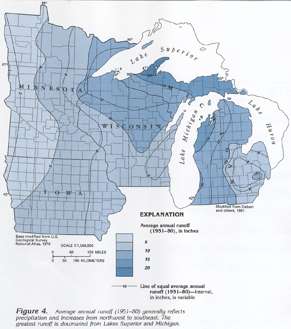
Average annual runoff in rivers and streams (fig. 4) generally reflects average annual precipitation patterns (fig. 3). Runoff generally increases from less than 1 to more than 20 inches. Runoff also tends to be substantial downwind from Lakes Superior and Michigan. However, in no part of the segment does runoff exceed precipitation. Much of the water from precipitation is returned to the atmosphere by evapotranspiration-evaporation from the land and water surfaces, and transpiration by plants. Some of the water is stored in aquifers through ground-water recharge or is stored on the land surface in lakes, marshes, and reservoirs. Runoff represents water from precipitation that runs directly off the land surface to streams and water discharged to streams that was stored in lakes, marshes, reservoirs, or aquifers.
LOCATION AND EXTENT OF MAJOR AQUIFER SYSTEMS AND AQUIFERS
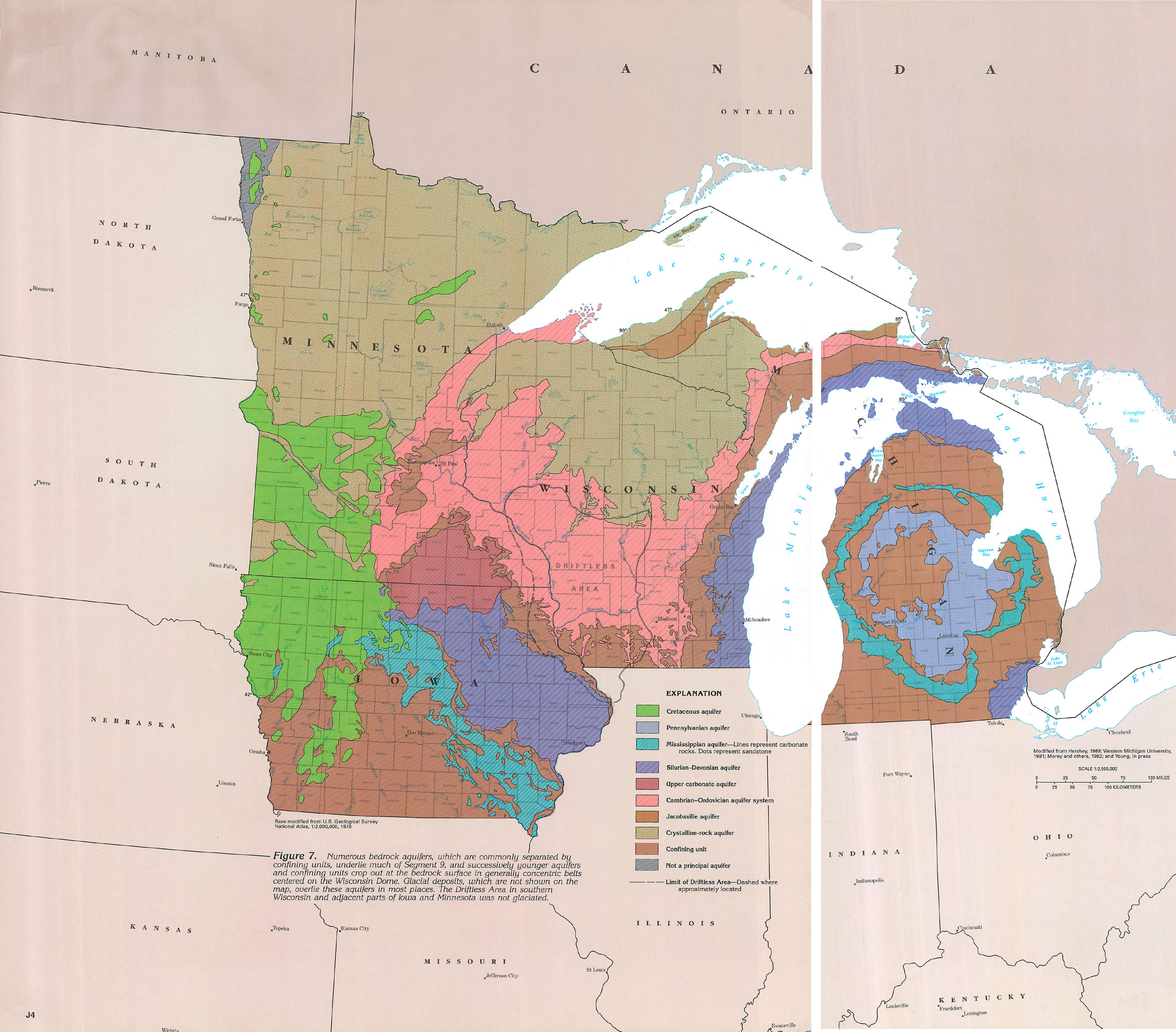
There are two major aquifer systems and seven major aquifers in Segment 9 consisting of rock types that range in composition from unconsolidated glacial deposits to hard crystalline rocks. An aquifer system consists of two or more aquifers that are hydraulically connected, and that function similarly in response to changes in hydrologic conditions. Because rock types generally correlate with geologic age in the segment, most aquifer systems and aquifers have been designated by age, according to local usage. The major aquifer systems and aquifers in Segment 9 are, in descending order: the surficial aquifer system, which is generally present throughout the segment; the Cretaceous aquifer in southwestern Minnesota and northwestern Iowa; the Pennsylvanian aquifer in central Michigan; the Mississippian aquifer in central and southeastern Iowa and central Michigan; the Silurian-Devonian aquifer in eastern Iowa, eastern Wisconsin, and northern and southeastern Michigan; the upper carbonate aquifer in southeastern Minnesota and northern Iowa; the Cambrian-Ordovician aquifer system in Iowa, most of southeastern Minnesota, much of Wisconsin, and northern Michigan; the Jacobsville aquifer principally in northern Michigan; and crystalline-rock aquifers in northern Minnesota and Wisconsin, and northwestern Michigan.
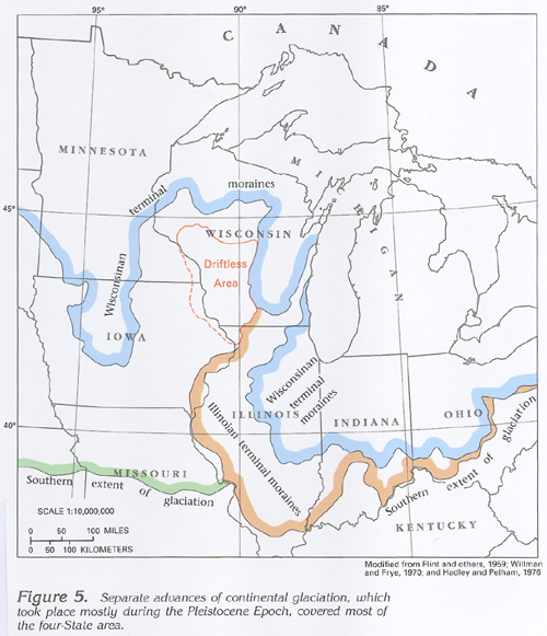
The surficial aquifer system is the uppermost, and most widespread, aquifer system in the four-State area. This system consists primarily of material deposited during multiple advances of continental glaciers from the north (fig. 5) during the Pleistocene and, possibly, Pliocene Epochs. The massive ice sheets planed off and incorporated soil and rock fragments during advances and redistributed these materials on the eroded land surface as water- or ice-contact deposits or both during retreats. Glaciofluvial or meltwater deposits, such as outwash, lake sand, kames, and eskers, are sorted and generally stratified deposits of sand or sand and gravel. These deposits, mapped in figure 6, generally form permeable bodies of sand and gravel that are exposed at the land surface and that readily receive, store, transmit, and discharge water. They are a primary source of water for wells throughout the four-State area and supply much of the base flow (fair-weather flow) of streams. Ground and terminal moraines, which are the dominant type of ice-contact deposit, normally are poorly sorted, unstratified deposits of clay, silt, sand, gravel, and boulders called glacial till.
Major bedrock aquifers that form the bedrock surface in Segment 9, including those that comprise the Cambrian-Ordovician aquifer system, are shown in figure 7, and all aquifer systems and aquifers are listed in figure 8. The surficial aquifer, for the most part, is present over the entire area.
The bedrock surface of Segment 9 is obscured by thin to extremely thick unconsolidated glacial deposits (representing the surficial aquifer system) except in the Driftless Area of southwestern Wisconsin and adjacent parts of Minnesota and Iowa (fig. 7), which have not been glaciated; in smaller areas, primarily in northern Minnesota and Wisconsin; and in the Upper Peninsula of Michigan, where the glacial deposits have been removed by erosion. The surficial aquifer system is generally hydraulically connected with each of the major bedrock aquifers in their area of outcrop.
All major bedrock aquifers, including those comprising the Cambrian-Ordovician aquifer system in Segment 9, crop out at the bedrock surface, but also extend into the subsurface and yield usable quantities of water in a much larger area than their outcrop, as in, for example, southwestern Minnesota and northwestern Iowa. Many of the aquifers do not end at the four-State border, but extend into adjacent segments (fig. 7). For example, the Cambrian-Ordovician aquifer system extends into Illinois (part of Segment 10). That part of the aquifer system is discussed in Chapter K of this Atlas.
IMPORTANCE OF MAJOR AQUIFER SYSTEMS AND AQUIFERS
The surficial aquifer system is the most widespread, extensively used, and easily accessible source of water in Segment 9. It consists chiefly of stratified sand and gravel, ice-contact deposits, and alluvium. Water is withdrawn from easily installed shallow wells for domestic and stock-watering uses throughout much of the segment and from deeper and larger wells for public supply, agricultural, and industrial uses. The aquifer system stores water and transmits it either along short flow paths to streams, thus sustaining base flow, or downward to underlying aquifers, thus providing recharge to the underlying aquifers where they subcrop at the bedrock surface. Because the surficial aquifer system is highly permeable throughout much of its area and is present at the land surface, it is vulnerable to contamination from human activities.
The Cambrian-Ordovician aquifer system underlies parts of each of the four States of Segment 9 (figs. 7, 8) and is the second largest source of ground water for public supply, agricultural, and industrial uses in the segment. The aquifer system consists of a sandstone and dolomite aquifer and two sandstone aquifers, which are separated by less-permeable confining units. The Maquoketa confining unit caps the aquifer system where it is overlain by younger bedrock.
The Silurian-Devonian aquifer, which is the third largest source of ground water in the segment, underlies the eastern one-half of Iowa, eastern Wisconsin, and parts of the Upper and the Lower Peninsulas of Michigan (figs. 7, 8). This aquifer is primarily a dolomite or limestone that yields water from solutionally enlarged fractures and karst features.
The Pennsylvanian aquifer is present only in the central part of the Lower Peninsula of Michigan (figs. 7, 8); however, this aquifer is the fourth largest source of ground water in Segment 9. The aquifer consists primarily of sandstone and is the principal bedrock aquifer in the Lower Peninsula.
The Cretaceous aquifer, which is present only in western Minnesota and Iowa (figs. 7, 8), is the fifth largest source of ground water in the segment and yields nearly as much water as the Pennsylvanian aquifer. The Cretaceous aquifer, which consists primarily of sandstone, yields moderate quantities of water of marginal quality; however, the aquifer is the only source of ground water in parts of its extent and, therefore, is considered to be a major aquifer.
The Mississippian aquifer (figs. 7, 8), which is present only in Iowa and Michigan, is the sixth largest source of ground water in the segment. The aquifer is dolomitic in Iowa where it is present in the southern part of the State. This aquifer consists of sandstone in the Lower Peninsula of Michigan and is a major aquifer in that area.
In southeastern Minnesota, the locally important upper carbonate aquifer (figs. 7, 8) is the seventh largest source of ground water in the segment. Karst development in a carbonate-rich part of the upper Maquoketa Formation and the Galena Dolomite (of the Maquoketa confining unit) has made these rocks extremely porous. These rocks and an overlying dolomitic Devonian formation form the upper carbonate aquifer, which is a large-yielding aquifer used for municipal and industrial supplies.
The Jacobsville aquifer in rocks of Precambrian age is adjacent to Lake Superior in the Upper Peninsula of Michigan (figs. 7, 8) and extends into Iron County, Wisconsin. The well-hardened sandstone aquifer is the eighth largest source of ground water in the segment and yields small quantities of water adequate for domestic and small-community uses. Because the aquifer is the only source of ground water where it is present, it is considered to be a major aquifer.
The crystalline-rock aquifer (figs. 7, 8), which forms the bedrock surface throughout a large area in northern Minnesota, northern Wisconsin, and the western Upper Peninsula of Michigan, is the ninth largest source of ground water in the segment. The aquifer consists predominantly of crystalline rocks that yield small to moderate quantities of water from joints and fractures. Although the aquifer is the least productive major aquifer in the segment, it is the only source of ground water in many parts of its extent and, thus, is considered to be a major aquifer.
GEOLOGY
The geologic and hydrogeologic nomenclature used in this report
differs from State to State because of independent geologic interpretations
and varied distribution and lithology of rock units. A fairly
consistent set of nomenclature, however, can be derived from the
most commonly used rock names. Therefore, the nomenclature used
in this report is basically a synthesis of that of the U.S. Geological
Survey, the Iowa Geological Survey Bureau, the Michigan Department
of Natural Resources, the Minnesota Geological Survey, and the
Wisconsin Geological and Natural History Survey. Individual sources
for nomenclature are listed with each correlation chart prepared
for this report.
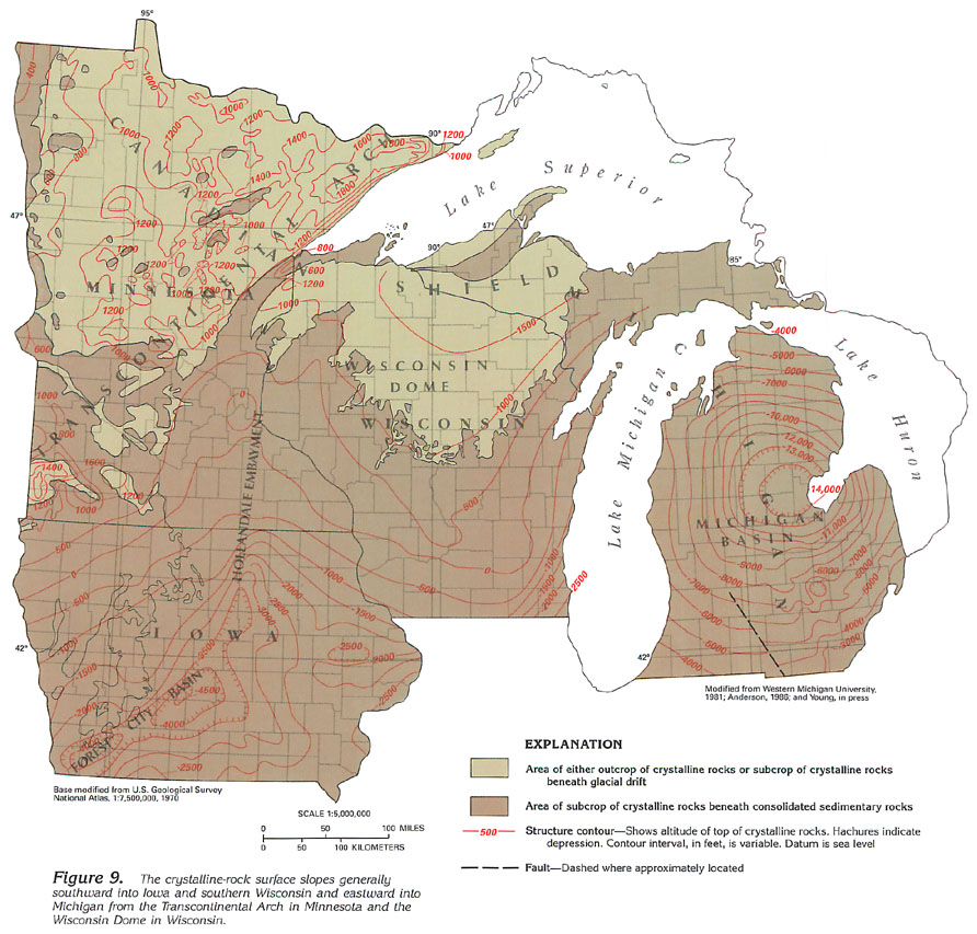
Segment 9 lies on the periphery of the Canadian Shield, which is a vast province of extremely old (Precambrian) and predominantly crystalline rocks in central Canada, northern Minnesota, northern Wisconsin, and the Upper Peninsula of Michigan. The surface formed by the Precambrian crystalline rocks is present throughout the segment as a floor or basement for the overlying Cambrian and younger sedimentary-rock sequence (fig. 9).
The crystalline-rock surface is an ancient erosional surface that yielded vast quantities of sediments through geologic time. The sediments derived from the weathering of the crystalline rocks were transported into multiple ancient seas that periodically encroached onto the crystalline-rock surface during the Precambrian and the Paleozoic. The sediments were deposited as extensive sequences of sandstone, shale, and limestone or dolomite that comprise the present-day sedimentary rock aquifers and confining beds.
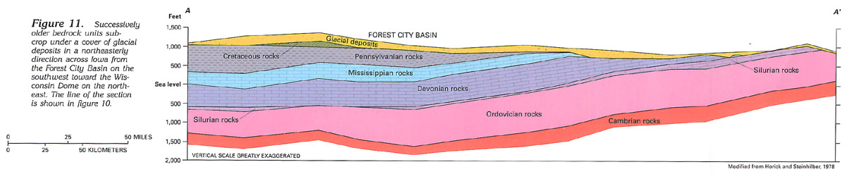
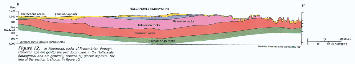
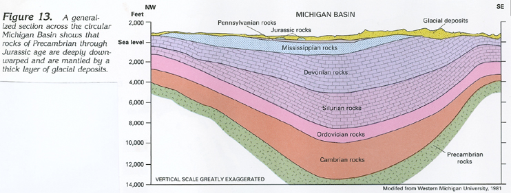
Because the crystalline-rock surface in Segment 9 slopes generally southward and eastward from its highest areas in Minnesota and Wisconsin, as shown in figure 9, the overlying sedimentary-rock sequence similarly dips and also thickens southward and eastward. Several structural features, which are shown in figure 9, controlled sedimentation in the segment. In northeastern Minnesota and north-central Wisconsin, the crystalline-rock surface rises to about 1,800 feet on the Transcontinental Arch and to about 1,500 feet above sea level on the Wisconsin Dome. These were the areas of erosion that produced the sediments. Areas of greatest sediment accumulation were the basins or low-lying areas on the crystalline-rock surface. The Hollandale Embayment of southeastern Minnesota, the Forest City Basin of southwestern Iowa, and the Michigan Basin in the Lower Peninsula of Michigan (fig. 9) are the principal basin areas; for example, sediments are about 14,000 feet thick in the circular Michigan Basin, and rocks in the segment dip into the basin from eastern Wisconsin and the Upper Peninsula of Michigan. Although not shown in figure 9, the Illinois Basin, which is centered in south-central Illinois, has affected sedimentation in Segment 9. Rocks in southern Wisconsin and southeastern Iowa dip toward the Illinois Basin. The Illinois Basin is discussed in greater detail in Chapter K (Segment 10) of this Atlas. Rocks in western Wisconsin and south-central Minnesota dip and thicken toward the center of the Hollandale Embayment. They continue to dip and thicken southwestward toward the Forest City Basin in southwestern Iowa.
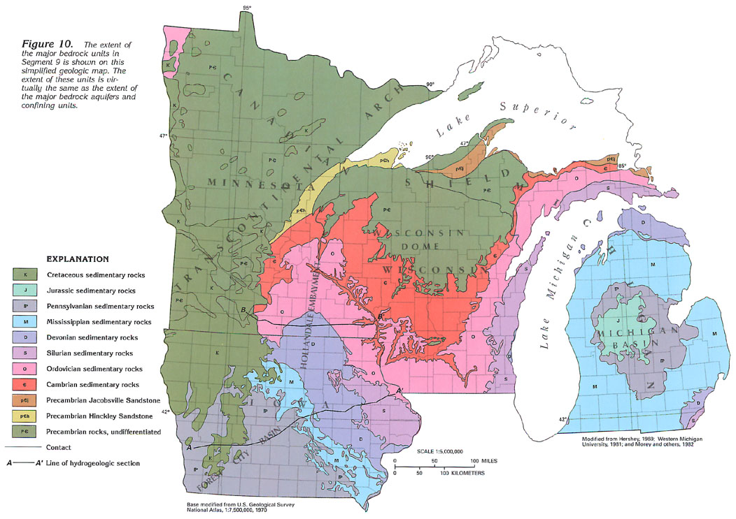
Postdepositional erosion of the sedimentary-rock sequence in Segment 9 has beveled off the sediments, especially in the topographically higher areas. As a consequence, successively younger rocks form the bedrock surface downdip from the Transcontinental Arch and Wisconsin Dome toward the Forest City, the Michigan, and the Illinois Basins (figs. 9, 10). A comparison of the hydrogeologic map in figure 7 and the geologic map in figure 10 shows this effect of geology on the occurrence and the distribution of bedrock aquifers. Sectional views in Iowa (fig. 11), Minnesota (fig. 12), and the Lower Peninsula of Michigan (fig. 13) emphasize the attitude of the rocks.
The eroded bedrock surface of crystalline and sedimentary rocks in Segment 9 was subjected to continental glaciation as recently as 10,000 years ago. Multiple glacial incursions into the area sculpted the bedrock surface, planed off loose and weathered rock, and deposited vast quantities of rock debris on the scoured bedrock surface. The unconsolidated glacial material was deposited as sorted and stratified water-laid material and as unsorted and unstratified ice-laid material.
The sorted and stratified water-laid deposits are the most permeable materials and, therefore, are the most productive aquifers. These materials were deposited by meltwater streams flowing from the glacier or were laid down in glacial lakes. Some of the meltwater streams flowed through deep bedrock valleys and deposited thick beds of sand and gravel (valley-train deposits) along the valleys. In many places, multiple meltwater streams deposited broad sheets of sand and gravel (outwash deposits) at the glacier front. In some places, stratified deposits that consist of thin layers of principally fine-grained material were laid down in glacial lakes. Stratified deposits also consist of mounds, hummocks, or terraces of sand and gravel (kame or kame-terrace deposits) deposited by meltwater along an ice margin or through an opening in the ice. Kame deposits tend to be extremely permeable and commonly have collapse features that are the result of the melting of remnants of glacial ice beneath the deposits. Some sorted and stratified deposits, especially those in deep bedrock valleys, were overridden by later glaciation and covered by till or glacial-lake deposits. Many of these buried deposits form productive aquifers; however, they are difficult to locate in the subsurface.
Till is unsorted and unstratified material that was deposited by the ice under and in front of the glacier. Till consists of unsorted clay, silt, sand, gravel, and boulders. Because of the heterogenous nature of till, it tends to have minimal permeability and yields only small quantities of water to wells.
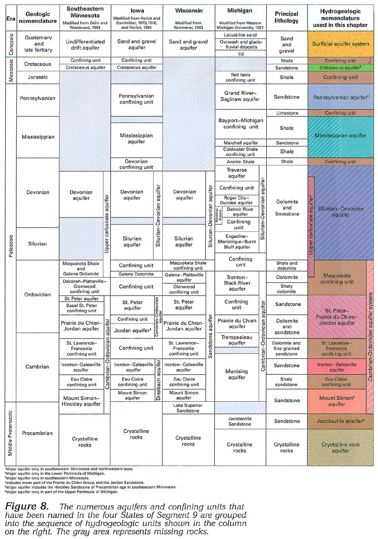
VERTICAL SEQUENCE OF AQUIFERS
The vertical sequence of aquifer systems, aquifers, and confining
units in Segment 9 varies from State to State; consequently, no
one location has a total representation. They are discussed in
descending order from geologically youngest to oldest. The vertical
sequence of aquifer systems, aquifers, and confining units in
each of the four States of Segment 9 is shown in the correlation
chart (fig. 8), and the sequence of aquifers in consolidated rocks
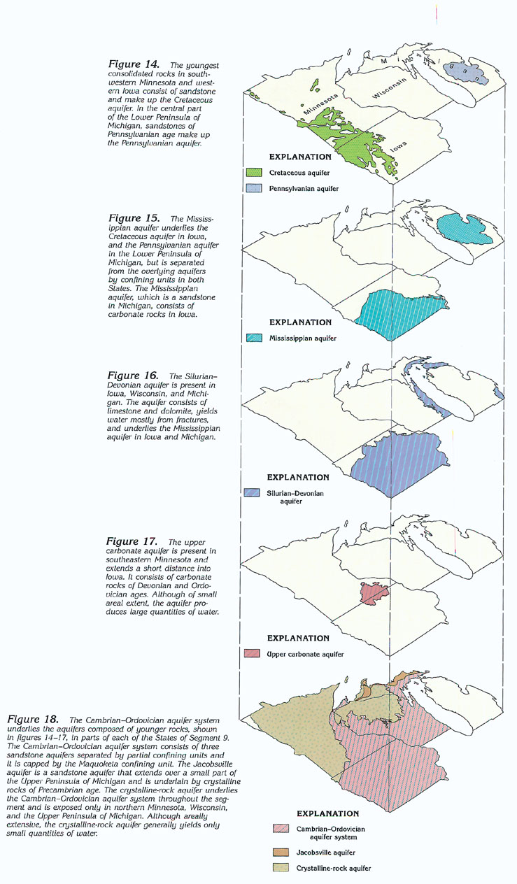
is shown in figures 14-18.
The surficial aquifer system consists of permeable, sorted and stratified sand and gravel deposits of glacial origin (aquifers) that commonly are interbedded with less permeable till (confining units). Because of its permeability and extent throughout most of the segment, the surficial aquifer system is hydraulically connected with nearly all bedrock aquifers. The bedrock aquifers are exposed at the land surface only in small areas; generally, they are covered by the surficial aquifer system, which provides an important component of storage from which water percolates downward to the underlying aquifers.
The Cretaceous aquifer is a sandstone unit in Cretaceous rocks and is present primarily in western and southwestern Minnesota and in northwestern Iowa (fig. 14). The aquifer is underlain by Precambrian crystalline rocks throughout much of its extent but overlaps onto rocks of Pennsylvanian through Cambrian age toward the south. The Cretaceous aquifer is hydraulically connected with many of the older bedrock aquifers where they subcrop under the Cretaceous rocks. In parts of northwestern Iowa, the Cretaceous aquifer is underlain by a confining unit of Pennsylvanian shale (fig. 8).
The Pennsylvanian aquifer is a sandstone unit in Pennsylvanian rocks, and is present only in the central part of the Lower Peninsula of Michigan (figs. 7 and 14). In places, the aquifer is overlain and confined by red shale of Jurassic age (red beds confining unit, fig. 8). The aquifer is underlain by a confining unit that consists mostly of limestone and shale of Pennsylvanian and Mississippian ages (Bayport-Michigan confining unit, fig. 8). The Pennsylvanian aquifer is most productive where it is overlain by the surficial aquifer system.
The Mississippian aquifer in Iowa consists of dolomite and forms the bedrock surface in the central and the southeastern parts of the State (figs. 7 and 15). In southwestern Iowa, the aquifer is overlain and underlain by shale confining units (fig. 8).
In the Lower Peninsula of Michigan, the Mississippian aquifer consists of sandstone and forms the bedrock surface in a circular pattern that reflects the structural basin (fig. 15). In most places, the aquifer is overlain by the Bayport-Michigan confining unit (fig. 8), which consists mostly of limestone and shale of Mississippian and Pennsylvanian ages and which hydraulically separates the aquifer from the overlying Pennsylvanian aquifer. The Mississippian aquifer is underlain by the Coldwater Shale confining unit, which consists of shale of Devonian and Mississippian ages. The contact between the Mississippian aquifer and the Coldwater Shale confining unit generally marks the base of freshwater in bedrock aquifers underlying the Lower Peninsula.
The Silurian-Devonian aquifer consists mostly of dolomite and limestone in which fracture permeability has been enhanced by solution and extensive karst development. The aquifer is present in eastern Iowa, the eastern part of Wisconsin, the southern part of the Upper Peninsula of Michigan, and the Lower Peninsula of Michigan (figs. 7 and 16). In Iowa, the aquifer forms the bedrock surface in the northeastern part of the State; in the southern and western parts, the aquifer is overlain by a confining unit of Devonian-age shale (fig. 8). The aquifer forms the bedrock surface throughout the area of eastern Wisconsin adjacent to Lake Michigan, in the southern part of the Upper Peninsula of Michigan, and in the northern and the southeastern parts of the Lower Peninsula. In these parts of Michigan, the aquifer only yields water adequate for domestic and small community supplies. In the rest of the Lower Peninsula of Michigan, the aquifer generally contains saltwater where it is overlain by the Coldwater Shale confining unit (fig. 8) and, therefore, is not developed.
The upper carbonate aquifer, which consists of Ordovician dolomitic shale and dolomite and overlying Devonian dolomite in southeastern Minnesota, is an extremely productive aquifer that extends a short distance into northern Iowa (figs. 7 and 17). The permeability of the aquifer has been substantially enhanced by extensive karst development. The aquifer is underlain by shaly dolomite of Ordovician age that forms the lower part of the Maquoketa confining unit (fig. 8). This confining unit also underlies the Silurian-Devonian aquifer.
The Cambrian-Ordovician aquifer system consists of three aquifers separated by two leaky confining units and is capped by the Maquoketa confining unit (fig. 8). This aquifer system is present in parts of each of the four States (figs. 7 and 18). In Minnesota and Michigan, the aquifer system is called the Cambrian-Ordovician aquifer (fig. 8). In Iowa, the upper part is called the Cambrian-Ordovician aquifer system, and the lower part is called the Dresbach aquifer (fig. 8). In Wisconsin, the aquifer system is called the sandstone aquifer (fig. 8).
In parts of Minnesota, Iowa, and Wisconsin, the Cambrian-Ordovician aquifer system crops out at the land surface in the Driftless Area (fig. 7). Elsewhere, the aquifer system crops out at the land surface only in small areas; it is generally overlain by either the surficial aquifer system or younger bedrock aquifers.
The Maquoketa confining unit, which is the uppermost confining unit of the Cambrian-Ordovician aquifer system (fig. 8), consists of shale and dolomite of Ordovician age. Only the lower part of the confining unit is present in southeastern Minnesota and northern Iowa where the Maquoketa Shale and the underlying Galena Dolomite form the lower part of the upper carbonate aquifer (fig. 8). In Wisconsin, Minnesota, and the Upper Peninsula of Michigan, the Galena-Platteville aquifer (fig. 8), which consists of dolomite of Ordovician age, is areally extensive but generally yields water only in small quantities and is not considered to be a major aquifer.
The St. Peter-Prairie du Chien-Jordan aquifer consists of an upper sandstone unit of Ordovician age (St. Peter Sandstone), a middle dolomite unit of Ordovician age (Prairie du Chien Group), and a lower sandstone unit of Cambrian age (Jordan Formation) and forms a major aquifer in southeastern Minnesota, northern Iowa, southern and eastern Wisconsin, and the Upper Peninsula of Michigan. Although the three units generally function as one aquifer, geologic conditions cause the significance and the relation of the units to change areally. For example, in Minnesota, the upper sandstone unit is locally separated by the shaly basal St. Peter confining unit from the underlying dolomite. In Iowa, rocks that are stratigraphically equivalent to the upper unit of the Prairie du Chien Group form a confining unit that separates the St. Peter aquifer from the lower part of the Prairie du Chien Group and the underlying sandstone. In Michigan, the upper sandstone unit is thin (fig. 8) and not permeable. Where either all three units are in direct contact, as in Wisconsin, or the middle and the lower units are in direct contact, as in Iowa, the aquifer is extremely productive. The St. Peter-Prairie du Chien-Jordan aquifer is underlain and confined by the St. Lawrence-Franconia confining unit throughout its area of occurrence.
The St. Lawrence-Franconia confining unit, which is present in Minnesota, Iowa, and Wisconsin (fig. 7), consists of a dolomite and a fine-grained sandstone of Cambrian age (fig. 8). In Michigan, some of the rocks that comprise the confining unit in the other three States are absent, and the remaining sandstone is sufficiently permeable to be included in either the St. Peter-Prairie du Chien-Jordan aquifer [called the Prairie du Chien and the Trempealeau aquifers in Michigan (fig. 8)] or the Ironton-Galesville aquifer [called the Munising aquifer in Michigan (fig. 8)]. Where present, the St. Lawrence-Franconia confining unit functions as a leaky confining unit.
The Ironton-Galesville aquifer (figs. 7, 8) consists of medium- to fine-grained sandstone of Cambrian age and is present in all four States; in Michigan, the aquifer is equivalent to the upper part of the Munising aquifer (fig. 8). In Minnesota, Iowa, and Wisconsin, the Ironton-Galesville aquifer is overlain by the St. Lawrence-Franconia confining unit, and, except in Michigan, the aquifer is underlain by the Eau Claire confining unit.
The Eau Claire confining unit, which is present in Minnesota, Iowa, and Wisconsin (fig. 8), consists of a shaly sandstone of Cambrian age; in Michigan, the sandstone is sufficiently permeable to be considered part of the Munising aquifer. Where present, the confining unit functions as a leaky confining unit between the overlying Ironton-Galesville aquifer and the underlying Mount Simon aquifer.
The Mount Simon aquifer consists of a medium- to fine-grained sandstone of Cambrian age and is the lowermost aquifer of the Cambrian-Ordovician aquifer system (fig. 8). The aquifer is present in all four States, although in Michigan, the aquifer is equivalent to the lower part of the Munising aquifer. In Minnesota, the aquifer includes the underlying Hinckley Sandstone of Precambrian age and the aquifer is called the Mount Simon-Hinckley aquifer. Also, in all four States, the aquifer overlies the crystalline-rock aquifer.
The Jacobsville aquifer consists of a sandstone of Precambrian age adjacent to Lake Superior in the Upper Peninsula of Michigan (figs. 7 and 18). A small part of the aquifer extends inland as far as Iron County, in Wisconsin. The aquifer is underlain by the crystalline-rock aquifer (fig. 8).
The crystalline-rock aquifer (fig. 7), which is the lowermost aquifer in the segment, consists of fractured crystalline rocks of Precambrian age. Although the crystalline rocks extend throughout the segment, they are not considered to be an aquifer except in northern Minnesota, northern Wisconsin, and part of the Upper Peninsula of Michigan where they are not deeply buried (fig. 18). Although the crystalline rocks yield small to moderate quantities of water from fractures in the upper part of the rocks, few fractures are at depth; thus, the rocks form an impermeable boundary at the base of the aquifer sequence.
GROUND-WATER QUALITY
The natural chemical quality of water from the principal surficial
and bedrock aquifers in the four-State area generally is suitable
for most uses. The quality, however, is variable as indicated
by the broad range of concentrations of a given dissolved constituent;
for example, maximum and minimum dissolved-solids concentrations
for 152 analyses of ground-water samples in Michigan differed
by a factor of 100. Freshwater in each of the aquifers is predominantly
a calcium magnesium bicarbonate type; that is, calcium and magnesium
ions constitute more than 50 percent of the cations, and bicarbonate
ions constitute more than 50 percent of the anions. In areas or
aquifers or both where dissolved-solids concentrations are greater
than normal, the proportions of sodium, sulfate, and chloride
ions also are large. Aluminum, boron, iron, fluoride, titanium,
radium-226, and hydrogen sulfide also are present in large concentrations
in some parts of the four States.
Saltwater (water with dissolved-solids concentrations in excess of 1,000 milligrams per liter) underlies much of western and extreme northeastern Minnesota, nearly all of Iowa, small parts of eastern Wisconsin, and the Lower Peninsula of Michigan. Much of this saltwater is present at depths of less than 1,000 feet.
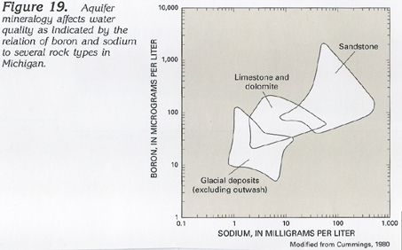
The chemical quality of natural ground water is primarily affected by the mineralogy of aquifer materials and the length of time that the water is in contact with these materials; for example, a plot of the relation of boron and sodium to rock types in Michigan (fig. 19) shows the differences that occur from contact of the water with various aquifer materials. Water deep within an aquifer, as well as that near the end of a long flow path, has generally been in contact with aquifer materials for a long time, which results in large concentrations of dissolved constituents. In general, water in outcrop and recharge areas of aquifers is the least mineralized, but water in deep, confined parts of aquifers where the water movement is sluggish tends to be the most mineralized.
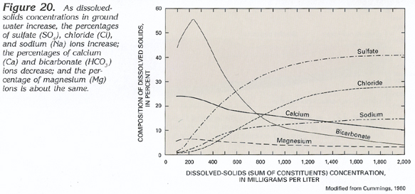
The chemical nature of ground water is characteristically related to dissolved-solids concentrations, as illustrated by data from Michigan in figure 20. As dissolved-solids concentrations increase, the percentages of sulfate, chloride, and sodium ions increase, the percentages of calcium and bicarbonate decrease, and the percentage of magnesium ions is about the same.
Because ion concentrations increase along flow paths, a progressive change that occurs in the water chemistry can be mapped as hydrochemical facies, or classification of waters based on their dominant cations and anions. A hydrochemical-facies map of water in the combined St. Peter-Prairie du Chien-Jordan and Mount Simon aquifers of the Cambrian-Ordovician aquifer system for the western part of Segment 9 is shown in figure 21. In unconfined recharge areas of the Cambrian-Ordovician aquifer system in southeastern Minnesota, northeastern Iowa, and most of Wisconsin and the Upper Peninsula of Michigan, calcium magnesium bicarbonate water prevails due to the short flow paths and the carbonate-rich minerals in the aquifer system.
In southwestern Minnesota and northwestern Iowa, a calcium sodium sulfate bicarbonate water is present in the Cambrian-Ordovician aquifer system. It probably has its source as recharge from the overlying Cretaceous aquifer where the oxidation of pyrite might be the source of the sulfate.
The water chemistry evolves from a calcium sodium sulfate bicarbonate water to a sodium calcium sulfate bicarbonate water (fig. 21) farther downgradient, possibly due to ion exchange of sodium for calcium by clay minerals in the aquifer system. In east-central and southern Iowa, the water further evolves to a sodium-mixed anion water, again possibly due to a continued ion exchange (sodium for calcium).
Calcium sodium sulfate chloride water in east-central Wisconsin (fig. 21) might be the result of updip migration of brines derived from evaporite deposits in the Michigan Basin during Pleistocene glaciation. The updip migration might have resulted from the depressing of the aquifer system by glacial ice. Farther downgradient toward Michigan, the water evolves to a sodium sulfate chloride water, which possibly is due to ion exchange (sodium for calcium).
FRESH GROUND-WATER WITHDRAWALS
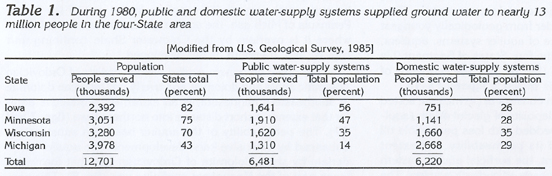
Ground water is a reliable source of water for nearly 13 million
people (table 1), or nearly 61 percent of the population of Segment
9. Water systems are approximately evenly divided between public
water-supply systems and private (domestic) water-supply systems.
Ground water is the source for nearly all public water-supply
systems in small cities (less than 10,000 population) and supplies
nearly 100 percent of the unincorporated rural areas.
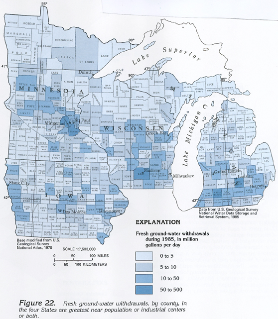
Total fresh ground-water withdrawals, by county, during 1985 in the four States of Segment 9 are illustrated in figure 22. Large withdrawals in counties of each State are related to large population centers or concentrations of industry or both. Many large cities located adjacent to major rivers or the Great Lakes (for example, Milwaukee, Wis.) withdraw surface water for public supply; their effect is not indicated on the map.
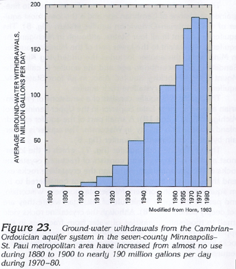
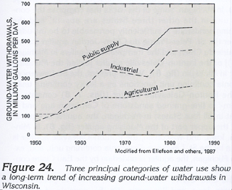
A trend of increasing withdrawal of ground water for all use categories in the four-State area is indicated by data from the seven-county Minneapolis-St. Paul metropolitan area of Minnesota (fig. 23) and from Wisconsin (fig. 24). The trend toward increasing withdrawals has been confirmed by a 1987 compilation of water-use data throughout the country by the U.S. Geological Survey.
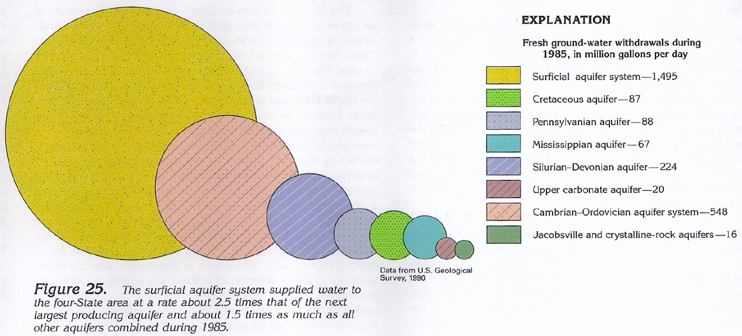
The freshwater withdrawn from principal aquifers in the four-State
area during 1985 is shown in figure 25.
The diameters of the circles are proportional to the rate of freshwater
withdrawal from each aquifer. The surficial aquifer system, which
is present throughout most of the four-State area, supplied water
at a rate of about 2.5 times as much as the next largest producing
aquifer and nearly 1.5 times as much as all other aquifers combined
during 1985. The Cambrian-Ordovician aquifer system is the
next largest producer and supplied water at a rate of about 2.5
times the third largest producer, the Silurian-Devonian aquifer.
The lesser producing Cretaceous, Pennsylvanian, Mississippian,
upper carbonate, and combined Jacobsville and crystalline-rock
aquifers are limited in areal extent or do not underlie population
or industrial centers or both with large water demands. Total
withdrawal from all aquifers during 1985 was 2,545 million gallons
per day.