
INTRODUCTION
Alaska is the largest State in the Nation and has an area of about 586,400 square miles, or about one-fifth the area of the conterminous United States. The State is geologically and topographically diverse and is characterized by wild, scenic beauty. Alaska contains abundant natural resources, including ground water and surface water of chemical quality that is generally suitable for most uses.
The central part of Alaska is drained by the Yukon River and its tributaries, the largest of which are the Porcupine, the Tanana, and the Koyukuk Rivers. The Yukon River originates in northwestern Canada and, like the Kuskokwim River, which drains a large part of southwestern Alaska, discharges into the Bering Sea. The Noatak River in northwestern Alaska discharges into the Chukchi Sea. Major rivers in southern Alaska include the Susitna and the Matanuska Rivers, which discharge into Cook Inlet, and the Copper River, which discharges into the Gulf of Alaska. North of the Brooks Range, the Colville and the Sagavanirktok Rivers and numerous smaller streams discharge into the Arctic Ocean.
In 1990, Alaska had a population of about 552,000 and, thus, is one of the least populated States in the Nation. Most of the population is concentrated in the cities of Anchorage, Fairbanks, and Juneau, all of which are located in lowland areas. The mountains, the frozen Arctic desert, the interior plateaus, and the areas covered with glaciers lack major population centers. Large parts of Alaska are uninhabited and much of the State is public land. Ground-water development has not occurred over most of these remote areas.
PHYSIOGRAPHY
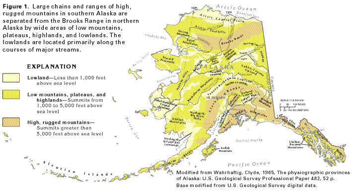
Most of Alaska is on a large peninsula that forms the northwestern
corner of the North American continent and separates the Arctic
Ocean from the Pacific Ocean (fig. 1).
The southeastern part of the State is on the main body of the
continental land mass. Alaska is separated from Russia by the
narrow Bering Strait and from the conterminous United States by
part of western Canada.
Large areas of high, rugged mountains in northern and southern Alaska are extensions of mountain systems in Canada. The Brooks Range in northern Alaska is the western terminus of the Rocky Mountain System. In southern Alaska, the Alaska and the Boundary Ranges, and the Talkeetna, the Wrangell, the Kenai-Chugach, and the St. Elias Mountains are extensions of the Pacific Mountain System. The south peak of Mount McKinley in the Alaska Range is the highest point in the United States and has an altitude of 20,320 feet above sea level. The Aleutian Range that extends as a long peninsula southwestward from the Alaska mainland is an extension of the Alaska Range. Parts of the summits and upper slopes of the southern mountain ranges and chains are covered with glaciers. In contrast, only small valley glaciers are present in the eastern parts of the Brooks Range.
Low mountains, plateaus, and highlands bound the high mountains and are, in turn, bounded by lowland areas (fig. 1). The lowlands are primarily along the courses of major streams and in coastal areas. Most of the cities, towns, and villages in Alaska are in the lowland areas.
CLIMATE
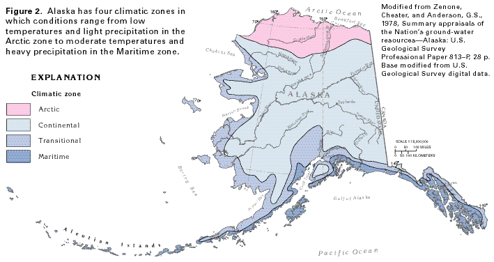
Alaska has a variable climate because of its large size, position
between two oceans, high latitude, and range in altitude of the
land surface. The State is divided into four climatic zones, based
on variations in precipitation and temperature (fig.
2). The Arctic zone is characterized by average annual precipitation
of less than 20 inches and an average annual temperature of 20
degrees Fahrenheit or less; seasonal variation in temperature
is small in this zone. The Continental zone extends over about
two-thirds of the State and is characterized by about 20 inches
of average annual precipitation and an average temperature of
about 22 degrees Fahrenheit. Temperature extremes are greater
in the Continental zone than in the other climatic zones. Average
annual precipitation in the narrow Transitional zone is about
30 inches, and temperatures average about 27 degrees Fahrenheit
annually. The Maritime zone is extremely wet compared to the other
three climatic zones; it averages about 70 inches of precipitation
annually. Average annual temperature in the Maritime zone is about
42 degrees Fahrenheit. This zone lacks prolonged periods of freezing
weather at low altitudes and is characterized by cloudiness and
frequent fog. The combination of heavy precipitation and low temperatures
at high altitudes in the coastal mountains of southern Alaska
accounts for the numerous mountain glaciers.
PRECIPITATION AND RUNOFF
Average annual precipitation (1951-80) varies greatly in Alaska
(fig. 3). Areas along the northern
part of the North Slope receive less than 10 inches of average
annual precipitation, whereas more than 160 inches has been recorded
in several places in the southern part of the State, adjacent
to the Gulf of Alaska and the Pacific Ocean. Locally, Sitka in
the southeastern part of the Maritime climatic zone receives more
than 300 inches of precipitation. The amount of precipitation
is directly related to topography; high, rugged mountains receive
the greatest amounts of precipitation and lowland areas receive
least (compare figs. 1 and 3).
Much of the precipitation falls as snow from November through March. Snow might fall year-round in the high mountains, where much of it is stored for long periods in glaciers and icefields. The glaciers of Alaska extend over about 17,000 square miles, which is about the size of the combined areas of Massachusetts and New Hampshire; perennial snowfields extend over an additional 13,000 square miles. The water content of the glacial ice is not released until the ice has moved to altitudes sufficiently low to allow the ice to melt. Likewise, water that is stored as snow on the land surface is not released until the spring melt. Several months (in the case of snow) or many years (in the case of glacial ice) may elapse between the time that precipitation falls and the time that it runs off.
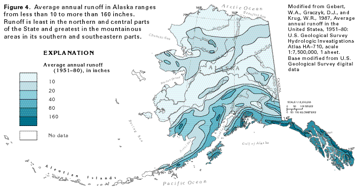
Average annual runoff (1951-80) in Alaska ranges from less than 10 inches in large areas of the northern and central parts of the State, and small areas near Cook Inlet and along part of the Copper River, to more than 160 inches in local areas in the southern and southeastern parts of the State (fig. 4). The pattern of distribution of runoff is similar to that of precipitation: both are least in lowland areas and greatest in mountainous areas. Average annual runoff over about two-thirds of Alaska is less than 20 inches.
Average annual precipitation minus the total of average annual direct runoff plus evapotranspiration (the combination of evaporation and transpiration by plants) is the amount of water potentially available to infiltrate downward to aquifers in their recharge areas. Although about one-half of Alaska receives less than 20 inches of average annual precipitation (fig. 3), conditions of low temperature, high humidity, and cloudy skies that prevail over most of the State minimize the rate of evaporation. Short summers minimize the time during which vegetation actively grows and, thus, negligible amounts of water are returned to the atmosphere by evapotranspiration. The small amount of evapotranspiration that does occur, however, may be a large percentage of the precipitation that falls in northern and western Alaska. Perennially frozen ground, or permafrost, inhibits infiltration of precipitation to underlying aquifers and promotes rapid runoff to streams.
PERMAFROST
Permafrost is soil, unconsolidated deposits, or bedrock that has
been continuously at a temperature of 32 degrees Fahrenheit or
less for two or more years. The term is synonymous with "perennially
frozen ground" but is defined solely on the basis of temperature;
locally, permafrost might contain very little water or ice, or
might contain highly mineralized water that remains liquid at
temperatures less than 32 degrees Fahrenheit. Most permafrost,
however, is consolidated by ice.
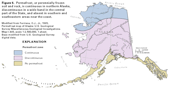
Permafrost is widespread in Alaska (fig. 5), but occurs only in small areas at high altitudes elsewhere in the United States. The thickness and areal continuity of permafrost are greatest in the continuous permafrost zone of northern Alaska and diminish southward. Locally, permafrost extends to depths of 2,000 feet below land surface in parts of the continuous permafrost zone. The wide zone of discontinuous permafrost shown in figure 5 contains isolated or interconnected unfrozen zones within the permafrost. In this zone, the thickness and lateral continuity of the permafrost decrease southward until only scattered, isolated areas of frozen ground are found near he southern limit of the zone. Areas near the southern and southeastern coasts of Alaska generally contain no permafrost.
The occurrence of permafrost is controlled by the heat balance at the surface of the earth. This balance is affected regionally by the average annual air temperature, which usually must be several degrees below 32 degrees Fahrenheit in order for permafrost to form and persist. The southward increase in average annual air temperature in Alaska is directly reflected by a southward decrease in the thickness and areal continuity of permafrost. The thickness of permafrost is determined by the average annual temperature of the ground surface, thermal properties of the soil and rock, and the geothermal gradient (the natural increase in the temperature of the earth with depth). Where the average annual ground-surface temperature is below freezing, permafrost may form and extend downward until the heat gained from the earth raises the local temperature above the freezing point. Much of Alaska's permafrost is thought to have formed partly during the Pleistocene Epoch, when temperatures were much lower than at present.
Factors that locally affect the surface heat balance, and thus, the presence and thickness of permafrost, include soil and rock type, relief, slope aspect (steepness and the direction which the slope faces), vegetation, snow cover, and the presence of surface-water bodies or flowing ground water. Different types of soils and rocks conduct heat at different rates and, thus, affect the depth and thickness of permafrost. Unvegetated soils may be warmer than vegetated soils because they lack the shading effect of the vegetation. In areas underlain by intrusive igneous rocks, the geothermal gradient may be higher than normal, thus limiting the thickness of permafrost, and where thermal springs issue from such rocks, they provide enough heat to locally thaw the permafrost. In the zone of discontinuous permafrost, silt in the alluvial and glacial deposits in lowlands is more likely to contain permafrost than sand and gravel interbedded with the silt. The sand and gravel beds might contain moving ground water that conducts sufficient heat to melt the permafrost. The insulating effect of thick snow tends to prevent the formation of permafrost locally; thick snow accumulations are more likely to form on gentle slopes than on steep slopes. Southward-facing slopes receive more solar radiation and, thus, are less likely to be underlain by permafrost than are northward-facing slopes. The warming effect of streams, rivers, lakes, and the ocean may extend to a depth of several hundred feet and result in local areas where permafrost is thin or absent.
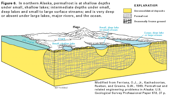
The relation of surface-water bodies to the depth and thickness of permafrost in the zone of continuous permafrost is shown in figure 6. Beneath the ocean, large, deep lakes, or large streams, permafrost is thin or might be absent. Beneath small, deep lakes or streams that are perennially ice-free, an unfrozen zone overlies the permafrost but is bounded by it on the sides. The water in such an unfrozen zone commonly is highly mineralized. Beneath small, shallow lakes or creeks that completely freeze during the winter, permafrost is present only a few feet below the bottom of the surface-water body. In the discontinuous permafrost zone, the permafrost is thinner, and most lakes and large rivers are underlain by unfrozen zones that perforate the permafrost.
Human activities can affect the local thickness of permafrost because changes in ground surface temperature of only a few degrees can change permafrost thickness. Removing natural vegetation and its insulating effect in the process of clearing land causes increased solar absorption, a rise in surface temperature, and thinning of permafrost. Conversely, adding fill during road building or other construction projects increases the thickness of insulating material above the permafrost and under these insulated roadways the permafrost is less likely to melt. Heat radiating from the floors of buildings constructed directly on the land surface can cause thinning of permafrost, whereas the shading effect of buildings constructed on pilings creates a less likely chance of the permafrost melting.
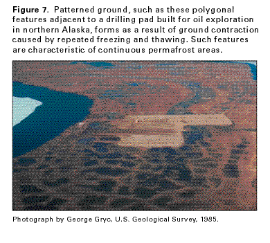
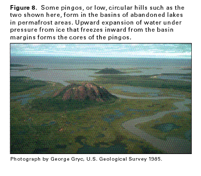
Permafrost is reflected by distinctive geomorphic features at the land surface. Small lakes are common to abundant in permafrost areas. In the zone of discontinuous permafrost, many of these lakes are "thaw lakes" that occupy shallow depressions and are unfrozen only in summer. Beaded drainage, or streams along which small pools appear to be connected like beads on a string, is an indicator of permafrost areas. Patterned (polygonal) ground such as that shown in figure 7 forms in permafrost areas where the ground freezes and then contracts on further cooling. Cracks that open during the contraction propagate downward well into the permafrost, where the temperature remains below freezing even during the melt season. When spring melt occurs at the surface, water runs down into the crack and refreezes at depth. This cycle of freezing, contraction, melting, and freezing again occurs each year, adding annual growth margins to the wedges, which intersect to form polygons. Pingos, or isolated, steep-sided, circular to oval hills (fig. 8) that range from 10 to more than 100 feet in height, form in permafrost areas. One way in which pingos form is by freezing of thawed and saturated sediments of drained lake basins. The sediments freeze inward from the sides of the basin and downward from the surface, and expand as they freeze. Water may be expelled from the sediments due to the volume expansion created by the freezing. The water pressure pushes upward an area of thin frozen sediment to form the core of a pingo. A few feet of silt, sand, and peat overlie the ice core.
RELATION OF PERMAFROST AND GROUND WATER
The principles of ground-water recharge, movement, and discharge
are, in general, as valid in permafrost areas as in more temperate
regions. However, ground-water flow systems in permafrost areas
are affected by cold climate and the presence of perennially frozen
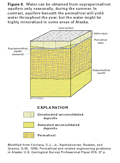
ground. The generalized diagram of permafrost conditions shown
in figure 9 is representative of the
northern and middle parts of the zone of discontinuous permafrost.
The top of perennially frozen ground is called the permafrost
table. Above the permafrost table is the active layer, a zone
that freezes in winter and thaws in summer; permeable, saturated
parts of the active layer constitute suprapermafrost aquifers.
These aquifers are seasonal and are primarily useful as a summer
water supply where they contain water of usable chemical quality.
Suprapermafrost aquifers are a source of freshwater for some villages
near the Arctic Ocean. In recent years, however, water pumped
from freshwater lakes in summer and stored in heated tanks for
winter use is a more likely source of supply. The permafrost table
forms a basal confining unit for the suprapermafrost aquifers.
Permeable material below the base of permafrost constitutes subpermafrost aquifers. In the zone of continuous permafrost, these aquifers consist mostly of consolidated rock; in the discontinuous permafrost zone, they commonly consist of unconsolidated deposits. Subpermafrost aquifers are used as sources of water supply in parts of the basins of the Yukon and Tanana Rivers where the aquifers contain freshwater. However, subpermafrost aquifers in parts of northern and western Alaska and in the Copper River Lowland contain highly mineralized water.
Permafrost affects ground-water recharge, movement, and discharge. The frozen ground blocks the downward percolation of rainfall or meltwater, and thus restricts recharge to subpermafrost aquifers. Where the permafrost table is shallow, it can perch water near the land and surface. Permafrost also blocks the lateral movement of ground water, and acts as a confining unit for water in subpermafrost aquifers. Discharge of water confined beneath the permafrost is possible only through unfrozen zones, or taliks, that perforate the permafrost layer. Although a huge quantity of water is stored in the permafrost, the water cannot be obtained and the presence of thick, continuous permafrost greatly limits the usefulness of most shallow aquifers.
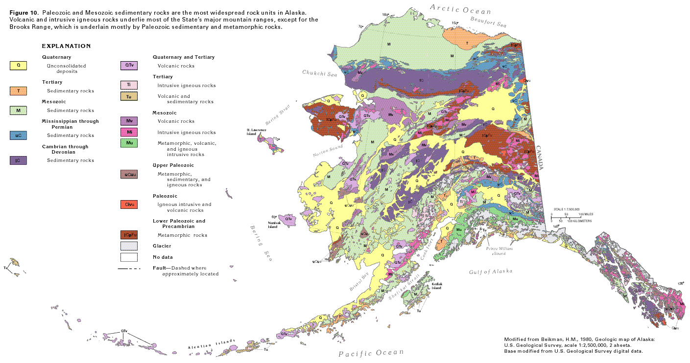
GEOLOGY
The rocks and unconsolidated deposits exposed in Alaska range
in age from Precambrian to Holocene. The distribution of major
categories of rock types is shown by a generalized geologic map
(fig. 10). Within each major mapped
category, rocks younger or older than those represented by the
category might crop out, but are not shown because of the map
scale. Glacial drift deposited during the Pleistocene Epoch by
large valley glaciers mantles mountain flanks and adjacent lowland
areas in most of the mountainous areas of Alaska. These drift
deposits and large areas of windblown silt (called loess) derived
from glacial deposits are likewise not shown on the map. Although
consolidated bedrock locally yields water to wells, especially
where the bedrock is fractured or contains large solution openings,
most ground water is withdrawn from permeable Quaternary deposits.
Modern interpretations of the complex geology of Alaska are based on the concept that the State is a mosaic of geologic terranes. A terrane is a body of rock of regional extent that is bounded by faults, and whose geologic history is different than that of adjacent terranes. All the terranes in Alaska represent blocks of the Earth's crust that have moved large or small distances relative to each other. The movement might have been translational (lateral movement without rotation) or rotational or both. Some of the terranes may have moved only a short distance, whereas others may have moved laterally for several hundred miles or rotated as much as 135 degrees. The pattern of terranes in Alaska reflects the interactions of oceanic crustal plates with the North American plate; large-scale lateral and rotational movements, rifting, and volcanic activity result from these interactions. A detailed discussion of Alaskan terrane theory and evidence is beyond the scope of this Atlas; an excellent summary of the topic can be found in Plafker and Berg (1994), listed in the References section of this atlas. Some of the large faults shown in figure 10 separate terranes.
Lower Paleozoic and Precambrian metamorphic rocks underlie most of central Alaska and much of the Seward Peninsula, the Yukon-Tanana Upland, the Kokrine-Hodzana Highlands, and the southern flank of the Brooks Range (compare fig. 10 with fig. 1). These rocks are primarily gneiss, schist, phyllite, and quartzite, but locally include argillite, marble, and several kinds of metasedimentary rocks. Local areas of Lower Paleozoic and/or Precambrian sandstone, limestone, shale, and chert in the northeast Brooks Range are mapped in this category. In the eastern part of the Yukon-Tanana Upland, Paleozoic intrusive and volcanic rocks of various kinds intrude, overlie, or are faulted against lower Paleozoic and Precambrian metamorphic rocks in an area of complex geology.
Cambrian through Devonian sedimentary rocks are widespread in the Brooks Range, the northwestern part of the Yukon-Tanana Upland, the northwestern and eastern parts of the Kuskokwim Mountains, the northeastern part of the Nushagak-Big River Hills, and southeastern Alaska. Smaller areas of these rocks are exposed in the easternmost part of the Alaska Range and in the Northern Foothills that border that range. These rocks consist mostly of sandstone, shale, and siltstone, but also include beds of limestone, dolomite, and chert. Cambrian through Devonian sedimentary rocks are complexly folded and faulted in the Brooks Range and are less deformed elsewhere.
Mississippian through Permian sedimentary rocks crop out mostly along the northern flanks of the Brooks Range, in the eastern part of the Porcupine Plateau (compare fig. 10 and fig. 1), in the northern and eastern parts of the Alaska Range, in the Wrangell Mountains and the northeastern part of the Kenai-Chugach Mountains, and locally in southeastern Alaska.These rocks are mostly limestone, shale, siltstone, and sandstone, but include beds of conglomerate, dolomite, and chert. Locally, marble, argillite, and metasedimentary and metavolcanic rocks are mapped in this category.
Upper Paleozoic metamorphic, sedimentary, and igneous rocks are exposed mostly in southeastern Alaska, the western parts of the Ahklun Mountains, and the southern part of the Nulato Hills. Metamorphic rock types mapped in this category include schist, gneiss, phyllite, and slate; sedimentary rocks include limestone, dolomite, chert, tuff, and volcaniclastic rocks; and igneous rocks include gabbro and basaltic to andesitic lava flows.
Mesozoic sedimentary rocks underlie large parts of the Arctic Foothills and the Arctic Coastal Plain, the Baird Mountains and the Indian River Upland south of the Brooks Range, most of the Nulato Hills, the Nushagak-Big River Hills, the Kuskokwim and the Ahklun Mountains, and the southern part of the Alaska Range. Smaller exposures of these rocks are in the Wrangell and the Talkeetna Mountains, the northern part of the Aleutian Range, the Kodiak Mountains, and the Chilkat-Baranof Mountains (compare fig. 10 with fig. 1). These rocks are mostly shale, siltstone, and sandstone, but locally include limestone and large deposits of coal.
Mesozoic volcanic rocks crop out in large areas of central Alaska, from the eastern side of the Seward Peninsula to the westernmost part of the Yukon-Tanana Upland to the northern part of the Kuskokwim Mountains. Smaller areas of these rocks are exposed in the Nulato Hills, the western part of the Ahklun Mountains, the Talkeetna and the Wrangell Mountains, and southeastern Alaska. These rocks range in composition from andesite to basalt.
Mesozoic intrusive rocks crop out in smaller areas than the Mesozoic volcanic rocks, but are widespread in central, southern, and southeastern Alaska. These rocks are mostly in upland and mountainous areas and range in composition from granite to gabbro. The widespread occurrence of these rocks, along with that of the Mesozoic volcanic rocks, shows that igneous activity was greatest in Alaska during Mesozoic time.
Mesozoic metamorphic, volcanic, and igneous intrusive rocks underlie large parts of the Kenai-Chugach Mountains and a small part of the Kodiak Mountains. These rocks consist of greenstone, limestone, chert, granodiorite, schist, and layered gabbro. Their contacts and extent are incompletely known because of glacial cover in many places.
Tertiary sedimentary rocks crop out mostly in the northeastern part of the Arctic Coastal Plain, near Cook Inlet and the northern part of the Gulf of Alaska, and in the northern part of the Aleutian Range. Smaller exposures of these rocks are along part of the Northern Foothills that flank the Alaska Range, and on the south-central flank of the Alaska Range. These rocks are primarily sandstone, siltstone, and shale, but also contain beds of coal, mudstone, and conglomerate.
Tertiary intrusive igneous rocks are prominent in the southern
part of the Alaska Range and in the Talkeetna Mountains. Smaller
exposures of these rocks are found in the eastern part of the
Yukon-Tanana Upland, the Kodiak Mountains, and on some of
the Aleutian Islands. These rocks range in composition from gabbro
to granite.
Tertiary volcanic and sedimentary rocks are exposed mostly in
the area around Prince William Sound, the southeastern side of
Kodiak Island, and in the Aleutian Islands. These rocks consist
of complexly interbedded sedimentary and volcanic rocks of early
Tertiary (Paleocene through Oligocene) age.
Quaternary and Tertiary volcanic rocks ranging in composition from rhyolite to basalt are prominent in large parts of central and southern Alaska and in the Aleutian Islands. Volcanic eruptions continue along Cook Inlet, on the Alaska Peninsula, and in the Aleutian Islands at the present time.
Quaternary unconsolidated deposits are present in lowland areas throughout Alaska. The deposits mapped in figure 10 represent only thick accumulations of these deposits; small areas of thin deposits are not shown. These deposits consist primarily of alluvium but also include glacial deposits and locally include eolian and beach deposits. In coastal areas, deltaic and marine deposits of Quaternary age are included in this map category.
AREAL DISTRIBUTION OF AQUIFERS
Information on subsurface geology, ground water, and permafrost
is sparse in Alaska, and for many places no data are available.
In large parts of the State, the surface geology is not well known.
It is difficult to extrapolate hydrologic conditions from the
few areas where they are known to different localities that have
similar geologic settings because local variations in geologic
and permafrost conditions significantly affect the occurrence
and movement of ground water.
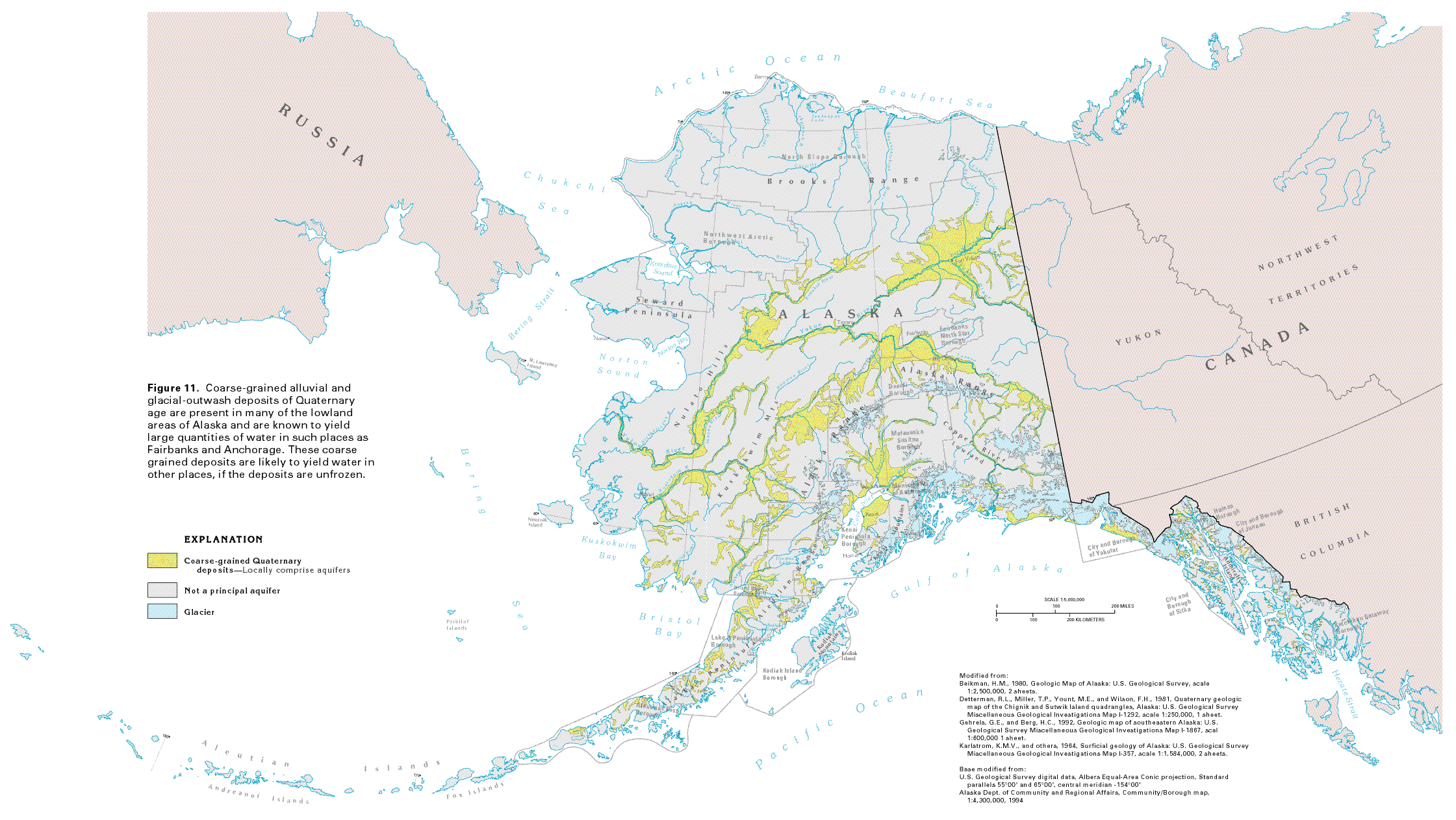
The aquifers of Alaska have never been mapped, except in the immediate vicinity of some of the towns and cities such as Kenai, Anchorage, Juneau, and Fairbanks. In other places, data from widely scattered drill holes, combined with maps of the surficial geology, allow some inference about the availability of ground water. The distribution of coarse-grained, unconsolidated alluvial and glacial-outwash deposits of Quaternary age is shown in figure 11. In many areas, such as the Tanana River basin, these deposits comprise thick aquifers that yield large quantities of water to wells. In other areas, such as the Copper River basin, widespread Quaternary deposits consist mostly of lacustrine silt and clay that are underlain by saline water and do not comprise aquifers. In the coastal area between Norton Sound and Bristol Bay, Quaternary deposits extend over large areas but are generally too fine grained to yield significant amounts of water. However, sand and gravel deposits such as those that provide the water supply for Bethel locally form productive aquifers. From the Brooks Range northward to the Arctic Ocean, Quaternary deposits contain continuous permafrost and, therefore, are not aquifers. In the northern part of the zone of discontinuous permafrost, the alluvial and outwash deposits are frozen during much of the year and exploration for local sources of ground water has generally not been conducted. In this region, however, scattered occurrences of large surface accumulations of ice during the winter indicate the presence of local aquifers.
Unconsolidated Quaternary deposits may locally be as thick as 1,000 feet in large basins such as the Yukon, the Kuskokwim, the Tanana, and the Copper River. The entire thickness, however, does not yield water. At depth, the deposits are likely to consist of fine grained marine or lacustrine sediments. A test hole drilled near Fort Yukon in 1994, for example, penetrated lacustrine sediments from a depth of 600 feet to the bottom of the hole at 2,000 feet.
Igneous, metamorphic, and sedimentary rocks underlie about 70 percent of Alaska. Although these rocks generally yield smaller amounts of water to wells than coarse-grained alluvial and outwash deposits, they are important aquifers in some parts of the State. In the Fairbanks area, approximately half the residents obtain water from wells completed in bedrock. Large springs that issue from carbonate rocks in the eastern part of the Brooks Range are reported to discharge as much as 16,000 gallons per minute. Carbonate bedrock on Admiralty Island in southeastern Alaska also yields large quantities of water from well-developed cave systems. In general, the water-yielding capability of bedrock in Alaska is not well known, however, and bedrock aquifers are not mapped in figure 11.
GROUND-WATER QUALITY
The concentration of dissolved solids in ground water provides
a basis for categorizing the general chemical quality of the water.
Dissolved solids in ground water primarily result from chemical
interaction between the water and the rocks or unconsolidated
deposits through which the water moves. Rocks or deposits composed
of minerals that are readily dissolved will usually contain water
that has large concentrations of dissolved solids. The rate of
movement of water through an aquifer also affects dissolved-solids
concentrations; the longer the water is in contact with the minerals
that compose an aquifer, the more mineralized the water becomes.
Thus, larger concentrations of dissolved solids commonly are in
water at or near the ends of long ground-water flow paths. Aquifers
that are in hydraulic connection with bays, sounds, or the ocean
commonly contain saline water, and mixing of fresh ground water
with this saline water can result in a large increase in the dissolved-solids
concentration of the freshwater. Contamination from human activities
can increase the concentration of dissolved solids in ground water;
such contamination usually is local but can render the water unfit
for human consumption or for many other uses.
The terms used in this report to describe water with different
concentrations of dissolved solids are as follows:
| Term | Dissolved-solids concentration, in milligrams per liter |
| Freshwater | Less than 1,000 |
| Slightly saline water | 1,000 to 3,000 |
| Moderately saline water | 3,000 to 10,000 |
| Very saline water | 10,000 to 35,000 |
| Brine | Greater than 35,000 |
Dissolved-solids concentrations in water from unconsolidated-deposit aquifers are less than 400 milligrams per liter in most places (table 1). An exception is the Copper River Lowland, where dissolved-solids concentrations in water from shallow and deep wells, and from some springs, exceed the 500 milligrams per liter recommended for drinking water by the U.S. Environmental Protection Agency. The large concentrations of dissolved solids in water from the Copper River Lowland reflect the upward movement of saline water from marine sediments that underlie the unconsolidated deposits.
Water from the aquifers in unconsolidated deposits is hard to moderately hard and, thus, may require treatment for some uses. Concentrations of iron in water from these aquifers are objectionable in many places, but the iron is easily removed from the water by inexpensive treatment. Iron concentrations in excess of 1,000 micrograms per liter are common; concentrations greater than 300 micrograms per liter can cause staining of laundry and porcelain plumbing fixtures, and impart a taste to the water. Locally, excessive concentrations of dissolved manganese and arsenic are reported in water from these aquifers.
Ground-water contamination from human activities can take place rapidly, and shallow aquifers such as those in unconsolidated deposits are particularly susceptible to contamination. Contamination related to human activities is categorized as being from a point source or a nonpoint source. A point source is a specific local site such as an underground storage tank that contains wastes, petroleum products, or chemicals; a landfill; a storage pond, pit, or lagoon; a spill of hazardous chemicals or petroleum products; or a disposal or injection well that receives municipal or industrial wastes. Nonpoint contamination sources are large-scale and can extend over hundreds of acres. Examples of nonpoint sources are: agricultural activities, such as applying fertilizer or chemicals to fields; urban areas with concentrations of septic tanks and cesspools; encroachment of saltwater or highly mineralized geothermal water; mining operations; oilfields and associated tank farms; and salt from highway deicing. Nitrate, a common contaminant from septic tanks, has been reported in ground water near Fairbanks in concentrations greater than the recommended Federal drinking-water standard of 10 milligrams per liter. These large nitrate concentrations, however, were present in places before significant development occurred, and are thought to result in part from the addition of nitrogen to the soil by plants such as alders.
The chemical quality of water from bedrock aquifers in Alaska
is known from a few areas where dispersed residential wells have
been drilled away from centralized water-distribution systems.
In the vicinity of Fairbanks, water from wells completed in bedrock
is generally a calcium bicarbonate type and usually is hard, especially
on the lower slopes. Locally, concentrations of arsenic and nitrate
in excess of the recommended Federal drinking-water standards
are reported. Water of chemical quality suitable for most uses
is reported from wells completed in bedrock aquifers in the Anchorage-Eagle
River area and in coastal communities bordering the Kenai and
the Kodiak Mountains. However, water from wells completed in coal-bearing
Tertiary strata in the Cook Inlet Basin commonly contains objectionable
concentrations of iron and hydrogen sulfide.
FRESH GROUND-WATER WITHDRAWALS
Although surface water is abundant in Alaska, many of the streams,
rivers, and lakes are covered with ice for much of the year. In
addition, streams that are fed by glaciers transport glacial silt
which gives the water a milky appearance and renders it unsuitable
for many uses unless the silt is removed by flocculation. Accordingly,
ground water is an important source of supply, especially in the
zones where permafrost is discontinuous or absent.
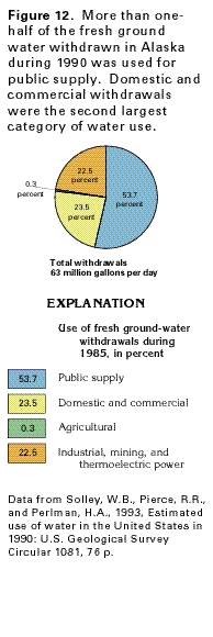
During 1990, ground water provided 23 percent of the total freshwater withdrawn in Alaska, but supplied 37 percent of the water withdrawn for public supply and 90 percent of that withdrawn for rural domestic use. Fairbanks, Juneau, and about 50 smaller communities depend almost entirely on ground water for supply. About 50 percent of the State's population is supplied by ground water.
The Municipality of Anchorage withdrew ground water at a rate of 11 million gallons per day during 1969, and withdrawals increased to more than 20 million gallons per day during 1985. Since 1985, however, Anchorage has constructed a new pipeline to Eklutna Lake north of the city. This lake and Ship Creek, which flows through the city, now supply most of the water needed by the municipality.
Most of the ground water in the Anchorage and Juneau areas is withdrawn from aquifers in unconsolidated deposits. Wells completed in unconsolidated deposits provide about one-half of the water withdrawn in the Fairbanks area; the remaining one-half is obtained from wells completed in bedrock. Bedrock supplies water to a significant number of wells in the hillside areas of Anchorage, on Kodiak Island, and on the Kenai Peninsula.
Total fresh ground-water withdrawals in Alaska during 1990 were about 63 million gallons per day (fig. 12). About 54 percent of this amount, or about 34 million gallons per day, was withdrawn for public supply. About 15 million gallons per day, or about 24 percent of the total withdrawals, were pumped for domestic and commercial use. Withdrawals for industrial, mining, and thermoelectric power use accounted for almost all the remainder of the water pumped. Only about 0.2 million gallons per day, or less than one-half of one percent, of the water withdrawn was used for agricultural purposes. About 48 million gallons per day of saline ground water was withdrawn for mining use during 1990.