GROUND WATER ATLAS of the UNITED STATES
Alaska, Hawaii, Puerto Rico and the U. S. Virgin Islands
HA 730-N
Puerto Rico and the U. S. Virgin Islands Regional Summary
There are two different files for each illustration
- A 72 ppi GIF file, suitable for screen viewing is accessed
through the thumbnail image.
- An eps file, suitable for downloading to be printed or edited
is accessed through the "eps file" link. Most files
are Adobe Illustrator 6.0, exceptions are noted. These files
have been compressed with GNU's gzip utility. If your web browser
defaults to a screen display of the file, turn on the "Load
to local disk" option before downloading. Download and process
these eps files as ascii, not binary.
Vertical Sequence of Aquifers, Aquifer Systems, and
Well Yields
Table 4 Table showing characteristics of aquifers in
Puerto Rico and the Virgin Islands (44K)
 editable eps
file Ntab04.eps.gz (376K compressed)
editable eps
file Ntab04.eps.gz (376K compressed)
Figure 74 Map showing the location of the
North Coast Limestone aquifer system, the South Coast aquifer
and the location of saline water in the principal aquifers of
Puerto Rico (20K)
 editable eps
file N074.eps.gz (89K compressed)
editable eps
file N074.eps.gz (89K compressed)
 editable eps
file Ntab04.eps.gz (376K compressed)
editable eps
file Ntab04.eps.gz (376K compressed) 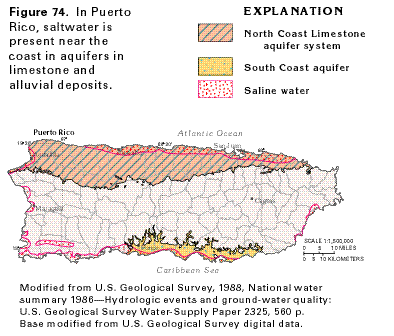 editable eps
file N074.eps.gz (89K compressed)
editable eps
file N074.eps.gz (89K compressed)