INTRODUCTION
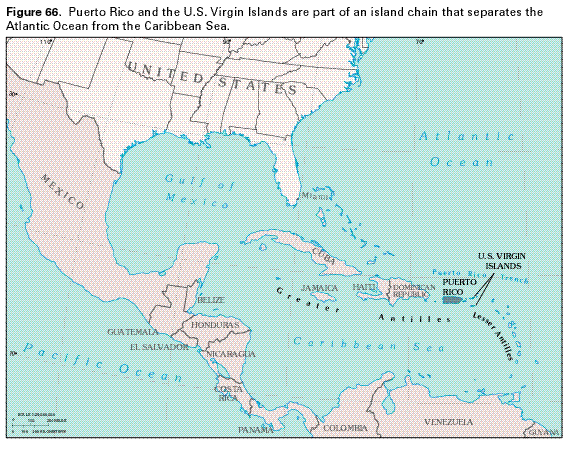
Puerto Rico and the Virgin Islands of the United States (fig. 66) are located about 1,100 miles east-southeast of Miami, Fla. The islands are part of the Greater Antilles island chain which, along with the Lesser Antilles island chain, separates the Caribbean Sea from the Atlantic Ocean. Puerto Rico and the Virgin Islands lie approximately 100 miles south of the Puerto Rico Trench, a depression of the ocean floor that reaches depths of 30,249 feet, the deepest known part of the Atlantic Ocean.
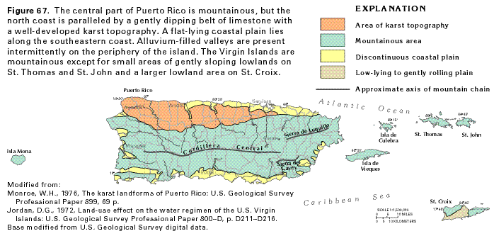
The main island of Puerto Rico is a rectangular-shaped island that extends approximately 110 miles from east to west and 40 miles from north to south (fig. 67). Puerto Rico and its three principal offshore islands-Vieques, Culebra, and Mona-have an overall area of about 3,471 square miles.
The Virgin Islands are about 50 miles east of Puerto Rico and consist of about 80 islands and cays. In this report, the Virgin Islands include only the three island territories of the United States-St. Croix, St. Thomas, and St. John. The three island territories also are the largest and most important of the Virgin Islands chain, with respective areas of approximately 84, 32, and 19 square miles.
The population of Puerto Rico was estimated to be about 3.4 million in 1985; approximately two-thirds of the people lived in cities, and the remaining one-third lived in rural areas. A population of about 104,000 inhabited the Virgin Islands in 1985; only about 30 percent of these people lived in urban areas. In Puerto Rico during 1985, ground water was the source of supply for approximately 16 percent of the population. Only a small percentage of the urban inhabitants of the Virgin Islands use ground water for water supply; however, ground water is an important supplemental source for rural inhabitants. Most of the population of Puerto Rico obtains its water supply from surface-water reservoirs. In the Virgin Islands, seawater desalination plants on St. Croix and St. Thomas are the principal sources of water supply for most urban areas; however, by law, all residences, hotels, and most public buildings are required to have cisterns supplied from rooftop precipitation collectors. Cruz Bay on St. John is primarily supplied by ground water. Culebra Island is primarily supplied by pipeline from Puerto Rico. Mona Island has no known source of water supply and is uninhabited.
Puerto Rico and the three principal U.S. Virgin Islands are mountainous with central highland areas that rise to a maximum altitude of about 4,400 feet above sea level in Puerto Rico and about 1,100, 1,560, and 1,280 feet above sea level on St. Croix, St. Thomas, and St. John, respectively. In Puerto Rico, the Cordillera Central, the Sierra de Luquillo, and the Sierra de Cayey generally are oriented east-west and dominate the mountainous southern two-thirds of the island (fig. 67). An area of gently dipping limestone that has been deeply dissected by dissolution forms a wide band of karst topography along most of the north coast. Flat-lying coastal plains and alluvial valleys compose a discontinuous belt around much of the periphery of the island. The coastal plain is especially prominent along part of the south coast where coalescing fan deltas were deposited by adjacent streams to form a broad, continuous plain.
In St. Thomas, flat, low-lying areas are limited to the Charlotte Amalie area and a few narrow beaches. St. John is similar to St. Thomas but has even less flat land; in St. John, flat land is limited mostly to the Cruz Bay and Coral Bay areas. The northwestern and eastern parts of St. Croix are formed by low mountains and rugged hills; however, the central and southwestern parts of the island are low-lying to gently rolling.
Drainage on each of the islands characteristically consists of short, deeply incised streams that have steep gradients in the upper reaches. Drainage generally is radial from the central highlands to the sea. Few of the streams along the southern coast of Puerto Rico, its offshore islands, or the U.S. Virgin Islands are perennial, but flow only after major precipitation and during sustained wet periods.
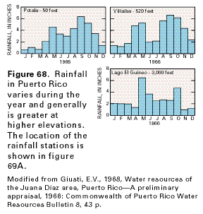
Precipitation in Puerto Rico and the Virgin Islands is highly variable, both seasonally and areally. Seasonally, a dry period begins in December and ends in March or April; it usually is followed by a period of intensive rainfall in April and May. A period of diminished rainfall in June and July is followed by the wet season that extends from August through November during which about 50 percent of annual rainfall occurs (fig. 68).
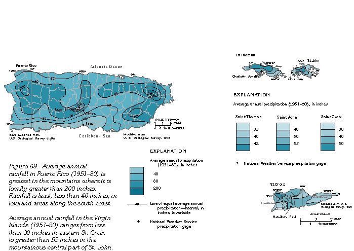
Areally, the orographic effect of the steep topography of highland areas causes average annual precipitation to vary almost in direct relation to altitude, but it also is affected by prevailing wind direction. Average annual precipitation in Puerto Rico ranges from less than 40 inches on the southern coastal plain to greater than 200 inches in the mountains (fig. 69A). Annual precipitation averages about 75 inches on the windward north coast of Puerto Rico compared to about 30 inches on the lee side of the island along the southwestern coast. Annual precipitation averages from less than 30 to greater than 55 inches in the Virgin Islands (fig. 69B).
Runoff in Puerto Rico and the Virgin Islands also varies seasonally
and areally in response to fluctuations in precipitation. Average
annual runoff (1951-80) in Puerto Rico ranges from about 20
inches on the northern and southern coasts to greater than 100
inches in the mountainous rain forest of the Sierra de Luquillo
(fig. 70). In general, runoff is greatest
during two periods that coincide with periods when precipitation
is greatest-in August through November and April through May.
Most streams have little flow during dry periods except for the
larger streams on the north, west, and south coasts of Puerto
Rico that originate in the igneous and volcanic rocks of the interior.
The northern and southern coastal streams especially are perennial
in coastal areas where they are underlain by limestone and thick
alluvium, and water from the limestone and alluvial aquifers discharges
to the streams as base flow.
Most of the precipitation is returned to the atmosphere by evapotranspiration-evaporation from the land and water surfaces and transpiration by plants. Average annual evaporation in Puerto Rico is estimated from pan evaporation to range from about 64 inches in the coastal areas to about 50 inches in the interior.
Some of the water from precipitation is stored in reservoirs on the land surface. There are 11 surface-water reservoirs in Puerto Rico with capacities in excess of 5,000 acre-feet. One acre-foot is the volume of water that would cover 1 acre to a depth of 1 foot. The water in some of these impoundments is used for hydroelectric power generation and irrigation water supplies. However, six of the island's reservoirs are used principally for public water supply. The impoundments also increase evaporation because they increase the area of standing water. This water loss is especially significant in the south coast area, where pan evaporation is almost twice the annual rainfall.
Some water from precipitation enters aquifers as ground-water recharge. Water that is stored in the aquifers might be released later either by withdrawal by wells, by evapotranspiration, or as seepage to streams.
AQUIFERS AND CONFINING UNITS
Principal aquifers in Puerto Rico and the Virgin Islands consist
mostly of limestone, alluvium, or volcanic rocks. The aquifers
generally are limited in areal extent and generally yield 500
gallons per minute or less to wells, although higher yields are
available locally. On all the islands, freshwater demand is high,
and, on the Virgin Islands, freshwater is in short supply; thus,
each of the aquifers is important as a source of water.
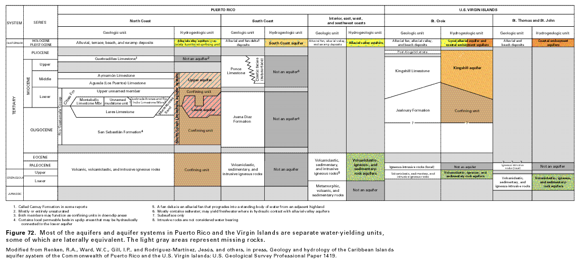
Principal aquifers and aquifer systems in Puerto Rico consist of the alluvial valley aquifers, the South Coast aquifer, and the North Coast Limestone aquifer system. An aquifer system consists of a heterogeneous body of interbedded permeable and poorly permeable material that functions regionally as a water-yielding hydraulic unit; it comprises two or more permeable beds (aquifers) separated at least locally by confining units that impede ground-water movement but that do not greatly affect the regional hydraulic continuity of the system. The North Coast Limestone aquifer system consists of an upper (mostly unconfined) and a lower (mostly confined) aquifer.
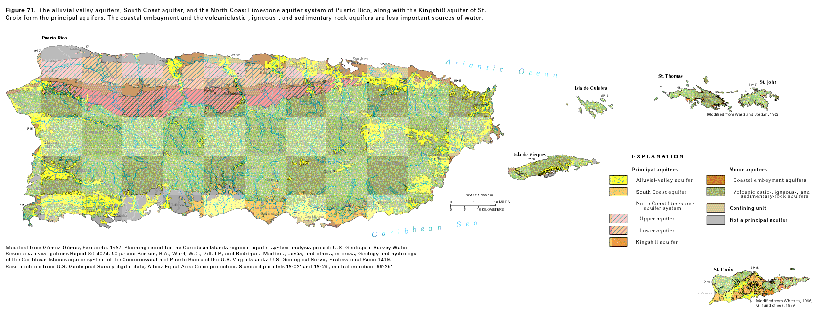
In the Virgin Islands, the only aquifer of major importance is the Kingshill aquifer on St. Croix. There are minor aquifers of three different types: alluvial valley aquifers, small alluvial aquifers called coastal embayment aquifers, and volcaniclas-tic-, igneous-, and sedimentary-rock aquifers that generally yield only enough water for domestic supply. The geographic distribution of the aquifers in Puerto Rico and the Virgin Islands is shown in figure 71, and some aquifer and well characteristics are listed in table 4. Figure 72 shows the vertical sequence of the aquifers and confining units, and the geologic formations that compose them.
Alluvial valley aquifers in Puerto Rico consist of river alluvium along the lower part of major river valleys on the east, west, north, and southwestern coastal areas and in the east-central interior valleys of rivers near Cayey, Caguas, and Juncos (fig. 71). Water generally is unconfined in these aquifers. The alluvium is present in valleys incised into limestone bedrock on the north and south coasts and into volcaniclastic rocks in the interior. The alluvium is as much as 300 feet thick in the north coast valleys and as much as 150 feet thick in the southwestern coast valleys. Valleys on the east and west coasts are incised into volcaniclastic or igneous intrusive bedrock and contain as much as 150 to 300 feet of alluvium. Near Cayey, Caguas, and Juncos, the alluvium is about 150 feet thick. The alluvial valley aquifers are an important source of public water supply for numerous municipalities in the coastal areas of Puerto Rico. Saltwater intrusion and upconing are problems in areas of large withdrawals.
The Esperanza-Resolución Valley aquifer is an alluvial valley aquifer that extends across the western end and along part of the southern coast of the island of Vieques (fig. 71). This aquifer was the principal freshwater source on the island and supplied about 8,000 inhabitants with freshwater prior to installation of a pipeline from Puerto Rico in 1978. The aquifer is mostly fine-grained alluvium derived from the weathering of dioritic rock and is underlain by weathered and fractured dioritic rocks; it is mostly a semiconfined aquifer. Because the Esperanza-Resolución Valley aquifer is no longer used, it is not discussed further. Similarly, the islands of Mona and Culebra lack any significant aquifers and are not discussed further in this report.
The South Coast aquifer in Puerto Rico extends from Patillas westward to Ponce (fig. 71). The aquifer consists of coalescing fan-delta and alluvial deposits that range in thickness from about 300 feet near the coast at Ponce to as much as 1,000 feet near Santa Isabel. Near the coast throughout most of the western half of the aquifer, freshwater is underlain by saline water at depths of about 250 feet or less. The aquifer generally is unconfined, but semiconfined conditions are created locally by interbedded silt and clay layers. The aquifer consists of fine-grained material, especially near the coast and at the coalescing edges of the fans. Coarser grained material generally is present in the central and upper parts or apex of each fan. The South Coast aquifer supplies about one-half of the total public water supply and irrigation needs of the south coast. The remainder is from surface-water sources. Withdrawals from the aquifer were estimated to be about 74 million gallons per day in 1985.
The North Coast Limestone aquifer system in Puerto Rico consists of an upper and lower aquifer separated by a confining unit (fig. 72) and extends from the western end of Puerto Rico to east of San Juan (fig. 71). It is composed of limestone and some clastic rocks that dip oceanward at an average angle of about 4 to 5 degrees along the southern outcrop belt and 1 to 3 degrees along the northern part. The rocks that compose the aquifers range in composition from sand, clay, and marl to nearly pure limestone. Water contained in the upper aquifer and the outcrop areas of the lower aquifer is largely unconfined, but the water in the subsurface parts of the lower aquifer and in some coastal parts of the upper aquifer is confined. This limestone aquifer system is the principal source of water for most municipalities and industries located between the Río Grande de Arecibo and the Río de la Plata.
The Kingshill aquifer is in the central and southwestern parts of the island of St. Croix (fig. 71). The Kingshill aquifer is capable of yielding about 5 to 50 gallons per minute to wells that penetrate its entire saturated thickness. The Kingshill Limestone mostly comprises the Kingshill aquifer (fig. 72), which consists of beds of soft yellow-orange to white limestone, limey clay (marl), thin sandy interbeds, and conglomerates. A younger, unnamed carbonate-rock unit and unconsolidated alluvium overlie the Kingshill Limestone in some localities. The younger carbonate rock is a productive part of the Kingshill aquifer but is of limited areal extent and importance. Alluvium is of broader areal extent and fills dissected stream courses; alluvial deposits store and subsequently release water to recharge the Kingshill aquifer. The Kingshill aquifer is underlain by the Jealousy Formation, which is a poorly transmissive limestone (known locally by drillers as a blue clay) that functions as the base of the hydrologic system. The thickness of the Jealousy is unknown, but is estimated to be greater than 6,000 feet and the formation presumably rests on volcanic rocks.
Coastal embayment aquifers are minor aquifers present in bays and inlets on each of the three islands of the Virgin Islands (fig. 71) and consist of unconsolidated deposits of alluvial and (or) beach sands. The aquifers generally consist of fine-grained material and range in thickness from 30 to about 50 feet. They are unconfined where they consist of coarse material but are semiconfined to confined where they consist of fine-grained sediments. Yields of wells completed in these aquifers range from 5 to 50 gallons per minute, but, in many places, only a small part of a coastal embayment aquifer contains freshwater, and wells commonly produce brackish water.
The volcaniclastic-, igneous-, and sedimentary-rock aquifers also are minor aquifers (fig. 71). They are intensely faulted and folded rock masses that consist mostly of volcaniclastic, igneous, and sedimentary rocks exposed in the central part of each of the islands and comprise tuffaceous siltstone, tuff stone, breccia, conglomerate, andesitic to basaltic lava, and minor limestone. The volcanic rocks have been intruded in places by plutonic rocks, such as granodiorite, quartz diorite, and serpentinized peridotite. In Puerto Rico, the volcani-clastic-, igneous-, and sedimentary-rock aquifers extend over nearly 2,000 square miles and constitute the major part of the island. The aquifers similarly extend over large parts of the Virgin Islands. The volcaniclastic rocks generally are not permeable, but where rainfall is significant, these rocks store and transmit water in fractures and other secondary openings. These rocks generally yield less than 10 gallons per minute to wells, especially in the areas intruded by plutonic rocks. However, where wells penetrate limestone beds or weathered intrusive rocks, they may yield moderate to large quantities of water to wells.
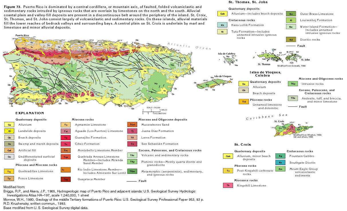
GEOLOGY
Puerto Rico and its outlying islands and St. Croix, St. Thomas,
and St. John in the Virgin Islands are part of an island arc that
largely consists of faulted and folded volcaniclastic and sedimentary
rocks that have been locally intruded by igneous rocks. These
rocks generally range in age from Cretaceous to Eocene, although
some rocks of Early Cretaceous-Jurassic age are present in southwestern
Puerto Rico. The volcaniclastic rocks form the mountainous and
highly irregular central core of each of the islands. Sedimentary
rocks, which are mostly limestones of Oligocene to Pliocene age,
overlie the volcaniclastic and sedimentary rocks in isolated areas,
and thick alluvial deposits of Quaternary age formed of material
eroded from the volcaniclastic and sedimentary rocks are along
many stream valleys, especially in coastal areas. Widespread unconsolidated
deposits that consist of coalescing alluvial fans or fan deltas,
dune and beach deposits, marine terrace deposits, and landslide,
swamp, and other miscellaneous deposits also overlie older rocks,
especially in the northern and southern coastal areas of Puerto
Rico (fig. 73).
In Puerto Rico, a thick limestone sequence that ranges in age from Oligocene to Pliocene (fig. 73) overlies volcaniclastic rocks in a continuous belt along the north coast. Locally, limestone beds not differentiated on figure 73 occur in a discontinuous belt along the southwestern coast and in isolated areas in the interior. The north coast limestones form important aquifers, but the southwestern coast and interior limestones generally yield significant quantities of water only locally.
The broad limestone belt in northern Puerto Rico extends west from Río Espíritu Santo to Aguádilla, a distance of about 90 miles (fig. 73). The belt reaches its maximum width near Arecibo, where it is about 14 miles wide. Six formations are recognized above the volcaniclastic rocks on which the sedimentary rocks were deposited. They are, in ascending order, the San Sebastián Formation, Lares Limestone, Cibao Formation, Aguada (Los Puertos) Limestone, Aymamón Limestone, and Quebradillas Limestone. A seventh formation, the Mucarabones Sand, is the eastern lateral clastic equivalent of the Lares Limestone and the lower two-thirds of the Cibao Formation. The sequence of these formations and their grouping into hydrogeologic units of the North Coast Limestone aquifer system are shown in figure 72.
Limestones in Puerto Rico have been extensively eroded by dissolution. Nearly all these rocks on the north coast and some on the south coast have well-developed karst features, but the limestones of the north coast are a classic example of karst topography, which features cone, tower, mogote, doline, and cockpit karst. All of these features are well-developed on the north coast limestone. Cone karst is a type of karst topography characterized by many steep-sided, near-vertical, cone-shaped hills surrounded by star-shaped depressions. Tower karst is a karst terrain characterized by vertical-sided hills. Mogote karst is characterized by steep-sided, conical limestone hills surrounded by flat alluviated plains. Doline karst refers to karst topography characterized by a closed depression or sinkhole. Cockpit karst refers to these star-shaped or irregular depressions which are surrounded by conical hills in cone karst terrain.
The attitude of the north coast limestone sequence is that of a homocline gently dipping to the north. The average angle of dip of the rocks is about 4 to 5 degrees to as much as 10 degrees at the contact with volcanic rocks to only about 1 degree at the coast. The limestone beds are undeformed and relatively flat-lying with a nearly east-west strike. In contrast, the local limestone beds in southern Puerto Rico generally dip southeasterly at angles from 10 to 30 degrees and strike in directions that range from north to east. The limestones of the south coast are characterized by extensive faulting and by horst and graben structures.
Sedimentary rocks in southern Puerto Rico compose the Juana Díaz Formation of Oligocene and Miocene age and the Ponce Limestone of Miocene to Pliocene age (fig. 73). The Juana Díaz consists of clay, mudstone, sand, gravel, chalk, and limestone. Much of the limestone is chalky, except for a very pure limestone in some of the reef complexes that also has undergone some dissolution. The reported maximum thickness of the Juana Díaz is about 2,300 feet, but it appears to be highly variable from area to area. The Ponce Limestone unconformably overlies the Juana Díaz and consists of a hard light-grayish-orange fossiliferous limestone that was deposited mostly in a shallow marine environment. The exact thickness of the Ponce is unknown, but some wells drilled in the formation have penetrated more than 650 feet of limestone. The Ponce Limestone shows only minor karst features.
Alluvial deposits of Quaternary age are in the downstream reaches of the major river valleys around the periphery of Puerto Rico and in a broad area of coalescing fan-deltas along the south coast (fig. 73). The deposits consist of clay, silt, sand, gravel, and cobbles eroded from bedrock of the river basins. The river valleys generally are incised into volcaniclastic rocks, but the lower part of four valleys in the Guánica, Yauco, Guayanilla, and Tallaboa areas in southwestern Puerto Rico are underlain by Tertiary limestones. The maximum thickness of alluvium is about 150 feet in these four valleys. In the alluvial plain that extends from Ponce eastward to Arroyo, block faulting has produced an irregular bedrock surface, and the thicknesses of alluvium ranges from about 90 feet near the shoreline at Arroyo to about 1,000 feet near Santa Isabel. The alluvium is coarse grained at the apexes of individual fans, but becomes finer grained at coalescing edges of the fans and toward the coastline.
The highland areas of St. Croix, St. Thomas, and St. John consist mostly of volcanic, volcaniclastic and sedimentary rocks of Cretaceous and early Tertiary age. This sequence has been intruded on St. Croix by gabbro and diorite and on St. Thomas and St. John by dioritic rocks. The eastern and western highland areas of St. Croix are separated by a graben filled with marl or foraminiferal mud of the Jealousy Formation of Oligocene (?) to Miocene age conformably overlain by marl and limestone of the Kingshill Limestone of Miocene age (fig. 73). The Jealousy and Kingshill Limestone were mostly formed from deep ocean carbonate mud sediments. The Kingshill Limestone extends over an area of about 30 square miles and also includes some terrigenous and carbonate turbidite deposits that occur as sandy interbeds. Unnamed post-Kingshill carbonate rocks locally overlie the Kingshill. Although the extent of these rocks is poorly known, they probably lie along the southern and western coastlines.
The Hans Lollik Formation of Cretaceous age consists of breccia and tuff but is largely limited to offshore islands that lie to the north of St. Thomas. The Outer Brass Limestone is a thin-bedded limestone that contains minor beds of tuff and has an estimated maximum thickness of 600 feet. The Tutu Formation of Cretaceous age is mostly a tuffaceous conglomerate that contains a few limestone beds (fig. 73). The maximum thickness of the Tutu is not known, but the formation is estimated to be more than 6,000 feet thick. The Louisenhoj Formation consists mostly of volcanic breccia and tuff. The Water Island Formation consists of extrusive volcanic rocks with minor intrusive dikes and plugs. Except for the Outer Brass Limestone, which yields small amounts of water to wells, none of the formations constitute an important source of water.
Quaternary deposits in the Virgin Islands consist of unconsolidated material that accumulated near the mouths of streams where they enter the ocean; beach deposits that surround ocean bays; and extensive alluvial fan, debris fan, and alluvial deposits of clay, silt, sand, and gravel that overlie the Kingshill and post-Kingshill Limestones on St. Croix. In the upstream reaches, the stream deposits typically consist of fine-grained alluvial material eroded from volcanic rocks in the stream basin. The stream deposits interfinger with coarser- grained beach deposits of sand and shell fragments in downstream reaches. The stream deposits typically are less than 30 to 50 feet thick and decrease in thickness to a featheredge upstream. They occupy valleys eroded into the volcanic-rock surface during an earlier period when sea level was lower than at present. The alluvial deposits generally are at an altitude of less than 100 feet above sea level.
Alluvium covers about one-fourth of the Kingshill Limestone in central St. Croix. This alluvium has an estimated maximum thickness of about 80 feet and consists mostly of clay, silt, and sand. Locally, the alluvium contains thin, discontinuous beds of sand and gravel. Silt- and clay-rich alluvial fan and debris flow deposits are usually less than 30 feet thick and are located along the northern margin of the central plain adjacent to the highlands.
VERTICAL SEQUENCE OF AQUIFERS, AQUIFER SYSTEMS, AND WELL YIELDS
Most of the aquifers and aquifer systems in Puerto Rico and the
Virgin Islands are separate water-yielding units, some of which
are laterally equivalent. They are discussed in descending order
from geologically youngest to oldest. The vertical sequence of
aquifers, aquifer systems, and confining units is shown in figure 72.
The alluvial valley aquifers, South Coast aquifer, and coastal embayment aquifers all consist of unconsolidated deposits of Holocene to Pleistocene age that generally overlie volcaniclastic or igneous intrusive rocks. Exceptions in Puerto Rico are alluvial valley aquifers in river valleys along the north coast, the western third of the South Coast aquifer, and four valleys in southern Puerto Rico where the unconsolidated deposits overlie limestone and some siliciclastic rocks. Alluvial valley aquifers along the east and west coasts and in the interior of Puerto Rico generally are in river valleys eroded into volcaniclastic rocks. The aquifers consist of fine to coarse sand and gravel, clay, and silt. Water in these aquifers generally is unconfined. The alluvium that composes the aquifers is local, exceeds 200 feet thick in some places, and yields of wells completed in the alluvium commonly are 50 to 150 gallons per minute.
In the limestone belt along the north coast of Puerto Rico, unconsolidated alluvial deposits of clay, silt, sand and gravel in the major river valleys are as much as 300 feet thick and yield from 50 to 150 gallons per minute to wells. These uncon-solidated deposits contain water under unconfined conditions and are hydraulically connected to the parts of the underlying North Coast Limestone aquifer system that also contain water under water-table conditions. Wells that penetrate both aquifers have yields as high as 800 gallons per minute.
Four valleys in southern Puerto Rico are filled with alluvium that consists primarily of permeable sand and gravel with hydrogeologic characteristics similar to the alluvium of the adjacent South Coast aquifer. The valley-fill alluvium is as much as 150 feet thick and yields from 150 to as much as 1,000 gallons per minute to wells. The Ponce Limestone and limestone beds of the Juana Díaz Formation underlie the four alluvial valleys. The combined thickness of the Ponce Limestone and the Juana Díaz Formation may be more than 2,500 feet in the Ponce-Tallaboa area. The limestones yield some water to wells, but the water mostly is highly mineralized with dissolved-solids concentrations that range from 1,500 to as much as 6,500 milligrams per liter. These limestones generally are not considered to be aquifers; however, where the limestone is tapped by wells that penetrate the overlying alluvium, yields of such wells generally are higher than those of wells open only to the alluvium. The clastic beds of the Juana Díaz Formation are not an considered to be an aquifer because of their low hydraulic conductivity and the high dissolved-solids concentrations of the water they contain.
The wide band of alluvial material along the south coast of Puerto Rico is called the South Coast aquifer. The boulder- to silt-size material that composes the aquifer overlies volcanic rocks except in the western part, where it overlies the Ponce Limestone and the Juana Díaz Formation. The South Coast aquifer consists of a series of coalescing fans or fan-deltas (fans in which alluvium in the seaward part of the fan was deposited in standing water) formed by fast-flowing streams. The sediments are of Holocene to Miocene age. They are mostly coarse-grained sand and gravel at the apex of each major fan but become finer-grained near the coast and in interfluvial areas. The alluvium ranges in thickness from about 350 feet near Ponce to as much as 1,000 feet near Santa Isabel. Yields of wells completed in the South Coast aquifer commonly range from 150 to 500 gallons per minute and might exceed 1,000 gallons per minute.
Coastal embayment aquifers, which are minor, are located mostly at the mouths of small streams that flow into bays and estuaries of the Virgin Islands. Freshwater from these aquifers is used mainly for domestic supplies and as feed water for reverse osmosis desalination plants. The aquifers contain water under unconfined conditions and consist largely of sand and gravel in beach and alluvial deposits that overlie weathered bedrock. The aquifers generally are 30 to 50 feet thick. Yields to wells are only about 5 to 50 gallons per minute, and the water generally is brackish.
The North Coast Limestone aquifer system consists of an upper and a lower aquifer separated by a confining unit. The upper aquifer consists of the Aymamón and Aguada (Los Puertos) Limestones and contains water under mostly unconfined conditions. The productive upper aquifer commonly yields 100 to 500 gallons per minute to wells and might yield as much as 1,000 gallons per minute (table 4). However, saline water generally is present in the aquifer within a mile or two of the coast. Underlying the upper aquifer, the clayey, poorly permeable upper unnamed member of the Cibao Formation (fig. 74) confines the lower part of the Cibao Formation (principally the Montebello Limestone Member, but locally also the Quebrada Arenas and Río Indio Limestone members), the underlying Lares Limestone, and the Mucarabones Sand, all of which form the lower aquifer. Where these older rocks crop out south of the confining unit in the Cibao Formation, they contain water under unconfined conditions; however, in most places, the water in the lower aquifer is confined. Yields of wells completed in the unconfined part of the lower aquifer seldom exceed 100 gallons per minute and generally are much less than yields of wells completed in the upper aquifer. However, within its confined parts, wells that tap the Montebello Limestone Member locally yield as much as 500 gallons per minute.
The Kingshill aquifer consists of the Kingshill Limestone and an overlying unnamed post-Kingshill carbonate-rock unit which form an unconfined aquifer that yields from 5 to 100 gallons per minute to wells. The aquifer consists mostly of marl and foraminiferal limestone and extends over about one-third of St. Croix. The Kingshill aquifer is overlain by and is in hydraulic connection with alluvium that infills river valleys cut into the limestone. The Kingshill aquifer is conformably underlain by the Jealousy Formation, a thick blue to blue-gray limestone and marl unit. Faulting has horizontally juxtaposed the entire sequence with volcanic rocks to the east and northwest.
The volcaniclastic-, igneous-, and sedimentary-rock aquifer is an unconfined fractured-rock aquifer that is present throughout large parts of each of the islands. Volcanic rock that has been folded, faulted, and intruded by diorite, gabbro, and other types of igneous rocks forms the central core of each of the islands and underlies all other aquifers. Fractures in these rocks store and transmit water in small quantities, and yields of wells completed in the aquifer generally range from 5 to 10 gallons per minute. The aquifer also includes small areas of limestone.
GROUND-WATER QUALITY
The natural chemical quality of water in the aquifers of Puerto
Rico generally is suitable for most uses. However, saltwater (water
with dissolved-solids concentrations in excess of 1,000 milligrams
per liter) is present in parts of each of the aquifers except
the artesian part of the lower aquifer of the North Coast Limestone
aquifer system and alluvial valley aquifers in the interior of
the island. The quality of the water in aquifers of the Virgin
Islands generally is not suitable for many uses, including drinking
water. In the Virgin Islands, water with dissolved-solids concentrations
of less than 1,000 milligrams per liter is not readily available;
accordingly, water with chloride concentrations of more than 500
milligrams per liter is used for drinking water.
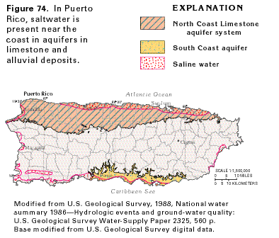
Contamination of aquifers from accidental spills of organic chemicals and from waste disposal is a widespread problem on each of the islands and has adversely affected a resource already in short supply. Excessive withdrawals from some aquifers, especially near the coasts, also have induced the intrusion of saltwater into freshwater aquifers in some places. In Puerto Rico, saltwater is present in the upper aquifer of the North Coast Limestone aquifer system and in alluvial aquifers adjacent to the ocean (fig. 74).
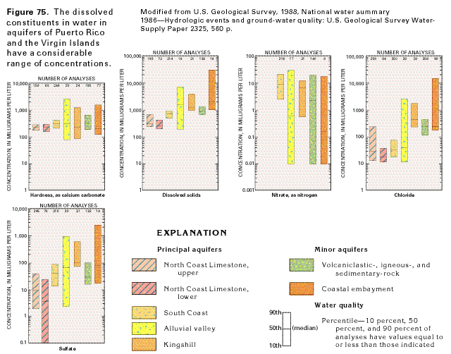
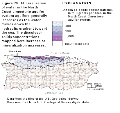
The chemical quality of water from the several aquifers of Puerto Rico and the Virgin Islands shows a considerable range in the concentration of principal ions, as illustrated in figure 75. In general, water contained within Caribbean Island aquifers tends to be more mineralized as the water moves downgradient toward the sea (fig. 76). Water in all the aquifers generally is a calcium magnesium bicarbonate type; concentrations of calcium and bicarbonate ions are sufficient to cause the water to be very hard. In some aquifers that are connected to the ocean, the freshwater head within the aquifers is in equilibrium with the saltwater head from the ocean (fig. 77). The freshwater-saltwater interface in the permeable parts of the alluvium generally is a short distance inland from the coast and is roughly wedge-shaped; the saltwater extends farther inland in the underlying upper aquifer of the North Coast Limestone aquifer system. Near the interface, the calcium magnesium bicarbonate freshwater typically changes to a calcium chloride type and then to a sodium chloride type over a short distance.
Distinct chemical environments have been recognized in each of the aquifers and are determined by a combination of aquifer mineralogy, permeability, and position in the ground-water-flow system. Generally in Puerto Rico, the least mineralized water, as indicated by dissolved-solids concentrations (fig. 75), is present in the lower aquifer of the North Coast Limestone aquifer system; water from the upper aquifer of this system, from the South Coast aquifer, and from the volcani-clastic-, igneous-, and sedimentary-rock aquifers is slightly more mineralized. Mineralization is successively greater in water from the Kingshill, the alluvial valley, and the coastal embayment aquifers. Mineralization of water in the aquifers of the Virgin Islands generally is greater than that of water in aquifers in Puerto Rico; however, the alluvial valley aquifers of Puerto Rico generally exhibit the largest range of concentrations of dissolved solids.
FRESH GROUND-WATER WITHDRAWALS
Total freshwater withdrawals from all sources in Puerto Rico and
the Virgin Islands were about 605 million gallons per day during
1985 and supplied a population of about 3.5 million people. Of
this total, ground-water withdrawals were about 29 percent, or
176.4 million gallons per day. In Puerto Rico, ground-water withdrawals
during 1985 were about 175 million gallons per day, of which about
48 percent (about 84 million gallons per day) was used for public
supply, largely in urban areas. Urban areas in the Virgin Islands
depend, for the most part, on desalination of seawater for all
uses. Ground-water withdrawals were about 1.4 million gallons
per day in the Virgin Islands during 1985.
Fresh ground-water withdrawals in Puerto Rico during 1985, shown in figure 78 by municipio (generally equivalent to a county), were concentrated in areas underlain by the principal aquifers. These areas also contain most of the population and industrial centers along the northern and southern coasts. The principal urban area of San Juan is supplied mostly by surface water. In the large rural area of the central mountains, on the eastern and western coasts, and on the offshore islands, ground-water use is minimal because of sparse population and the lack of productive aquifers. Similarly, in the Virgin Islands, the limited areal extent and low productivity of the aquifers, and the generally marginal chemical quality of the ground water available have resulted in the use of desalinated seawater as the principal source of potable water.
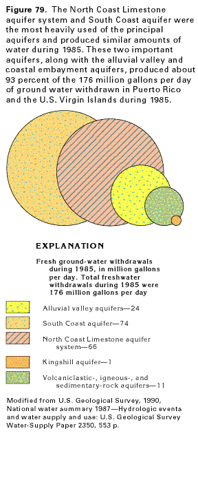
During 1985, the South Coast aquifer was the most heavily used of the principal aquifers (fig. 79). Fresh ground-water withdrawals from this aquifer amounted to about 74 million gallons per day, or about 42 percent of total withdrawals in the islands. About 66 million gallons per day, or about 38 percent, was withdrawn from the North Coast Limestone aquifer system. A much smaller, but still significant, amount of about 24 million gallons per day, or about 14 percent of the total, was withdrawn from alluvial valley aquifers in Puerto Rico. The volcaniclastic-, igneous-, and sedimentary-rock aquifers, which underlie the largest area of the islands, also produced a significant amount of water (about 11 million gallons per day, or about 6 percent of total withdrawals). Withdrawals from the Kingshill aquifer on St. Croix were about 1 million gallons per day, or only about 0.6 percent of total withdrawals. Small amounts of water were withdrawn from the coastal embayment aquifers in the Virgin Islands.
GROUND-WATER PROBLEMS
Water availability and chemical quality are the principal ground-water
problems in Puerto Rico and the U.S. Virgin Islands. The estimated
maximum withdrawal rate of fresh ground water in Puerto Rico is
440 million gallons per day; withdrawals during 1985 were about
175 million gallons per day, and projected development of agriculture,
industry, and domestic facilities might require an additional
100 million gallons per day by the year 2000. Ground water generally
is available in large quantities only on the periphery of the
island and especially along the northern and southern coasts.
On the Virgin Islands, freshwater aquifers are limited in extent
and ground water supplies only about 10 percent of the total water
use. The Kingshill aquifer on St. Croix is the most productive
aquifer, with a yield of about 1 million gallons per day.
Ground-water quality problems result from point sources of contamination and from saltwater intrusion. There are more than 100 solid-waste disposal sites in Puerto Rico, as well as an unknown number of wells used for the disposal of industrial wastes. These sources of pollution, coupled with the presence of karst features such as sinkholes that breach limestone aquifers and the fracture system of the volcaniclastic-, igneous-, and sedimentary-rock aquifers, make these aquifers extremely susceptible to contamination and indicate the widespread potential for ground-water contamination. In a recent reconnaissance study of ground-water quality in Puerto Rico, a variety of organic pollutants were detected. In places, the organic compounds were present in concentrations that exceed secondary maximum contaminant levels established by the U.S. Environmental Protection Agency. Six water-supply wells have been abandoned because of unacceptable levels of organic pollutants, and water from 13 other wells is being closely monitored. In St. Thomas, productive wells in the volcaniclastic-, igneous-, and sedimentary-rock aquifers were shut down because of contamination from oil and other organic compounds.
The proximity or direct connection of aquifers to the sea in Puerto Rico and the Virgin Islands makes upconing of saltwater as a result of excessive withdrawals, or saltwater intrusion as a result of decreased recharge during dry periods, a perpetual concern. Large concentrations of sodium and chloride in ground water can result from salt that enters the shallow aquifers from windborne sea spray, which is a ubiquitous problem near the coasts.