
This digital map database represents the general distribution of bedrock and surficial deposits of the Yosemite National Park vicinity. It was produced directly from the file used to create the print version in 1989. The Yosemite National Park region is comprised of portions of 15 7.5 minute quadrangles. The original publication of the map in 1989 included the map, described map units and provided correlations, as well as a geologic summary and references, all on the same sheet. The database delineates map units that are identified by general age and lithology following the stratigraphic nomenclature of the U.S. Geological Survey. The scale of the source maps limits the spatial resolution (scale) of the database to 1:125,000 or smaller. Purpose: |
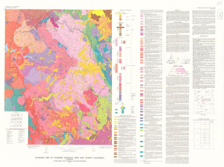 |
| This illustration is a .gif (GIF) image of the geologic map of Yosemite National Park and vicinity. |
| File
Name |
File
Type and Description |
File
Size |
| Text file that gives more information about this publication |
8 Kb |
|
| Text file of the FGDC-compliant metadata |
16 Kb |
|
| Compressed file of the digital database for this map |
1.5 MB |
|
| PDF file of map sheet that can be used for viewing map in a browser, as well as for plotting. This PDF was created by scanning an existing map. | 12.2
MB |
For questions about the content of this report, contact Doug Morton
Download a current version of Acrobat Reader for free
| Help | PDF help | Geopubs main page | I Maps |
| Privacy Statement | Disclaimer | Accessibility |
| Geologic Division | Earth Surface Processes |
This report is available only on the Web