By Douglas B. Yager and Helen W. Folger
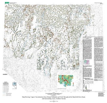
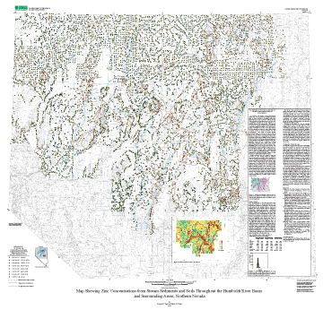
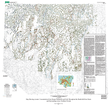
| • A : Scandium | • B : Iron | • C : Cobalt | • D : Nickel | • E : Copper | • F : Zinc | • G : Arsenic |
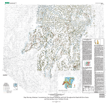
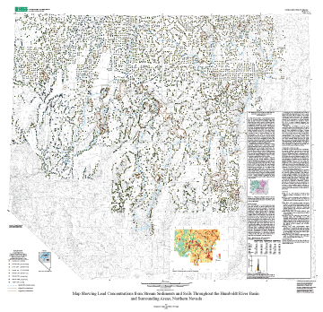
| • H : Selenium | • I : Silver | • J : Antimony | • K : Cerium | • L : Gold | • M : Lead | • GIS Files |
By Douglas B. Yager and Helen W. Folger
Version 1.0
The text of this report is presented here in Portable Document Format. The latest version of Adobe Acrobat Reader or similar software is required to view it. If you wish to download the latest version of Acrobat Reader free of charge, click here.
Text Only
PDF file (85 KB)
(This version of the report is accessible as defined in Section 508.)
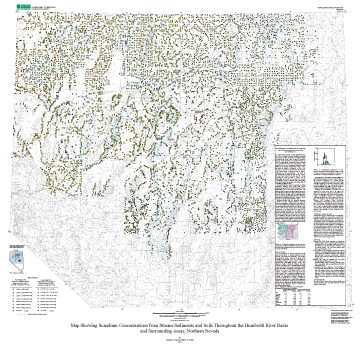
U.S. Geological Survey Miscellaneous Field Studies Map MF-2407-B
By Douglas B. Yager and Helen W. Folger
Version 1.0
The text of this report is presented here in Portable Document Format. The latest version of Adobe Acrobat Reader or similar software is required to view it. If you wish to download the latest version of Acrobat Reader free of charge, click here.
Text Only
PDF file (88 KB)
(This version of the report is accessible as defined in Section 508.)
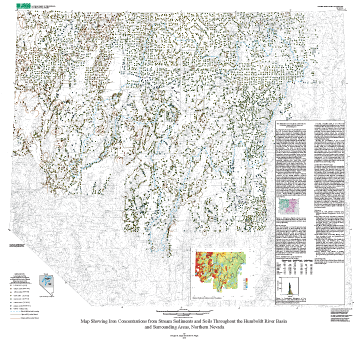
U.S. Geological Survey Miscellaneous Field Studies Map MF-2407-C
By Douglas B. Yager and Helen W. Folger
Version 1.0
The text of this report is presented here in Portable Document Format. The latest version of Adobe Acrobat Reader or similar software is required to view it. If you wish to download the latest version of Acrobat Reader free of charge, click here.
Text Only
PDF file (94 KB)
(This version of the report is accessible as defined in Section 508.)
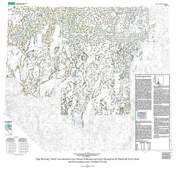
U.S. Geological Survey Miscellaneous Field Studies Map MF-2407-D
By Douglas B. Yager and Helen W. Folger
Version 1.0
The text of this report is presented here in Portable Document Format. The latest version of Adobe Acrobat Reader or similar software is required to view it. If you wish to download the latest version of Acrobat Reader free of charge, click here.
Text Only
PDF file (90 KB)
(This version of the report is accessible as defined in Section 508.)
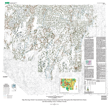
U.S. Geological Survey Miscellaneous Field Studies Map MF-2407-E
By Douglas B. Yager and Helen W. Folger
Version 1.0
The text of this report is presented here in Portable Document Format. The latest version of Adobe Acrobat Reader or similar software is required to view it. If you wish to download the latest version of Acrobat Reader free of charge, click here.
Text Only
PDF file (97 KB)
(This version of the report is accessible as defined in Section 508.)
U.S. Geological Survey Miscellaneous Field Studies Map MF-2407-F
By Douglas B. Yager and Helen W. Folger
Version 1.0
The text of this report is presented here in Portable Document Format. The latest version of Adobe Acrobat Reader or similar software is required to view it. If you wish to download the latest version of Acrobat Reader free of charge, click here.
Text Only
PDF file (96 KB)
(This version of the report is accessible as defined in Section 508.)
U.S. Geological Survey Miscellaneous Field Studies Map MF-2407-G
By Douglas B. Yager and Helen W. Folger
Version 1.0
The text of this report is presented here in Portable Document Format. The latest version of Adobe Acrobat Reader or similar software is required to view it. If you wish to download the latest version of Acrobat Reader free of charge, click here.
Text Only
PDF file (105 KB)
(This version of the report is accessible as defined in Section 508.)
U.S. Geological Survey Miscellaneous Field Studies Map MF-2407-H
By Douglas B. Yager and Helen W. Folger
Version 1.0
The text of this report is presented here in Portable Document Format. The latest version of Adobe Acrobat Reader or similar software is required to view it. If you wish to download the latest version of Acrobat Reader free of charge, click here.
Text Only
PDF file (89 KB)
(This version of the report is accessible as defined in Section 508.)
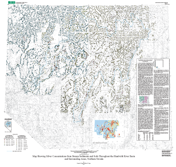
U.S. Geological Survey Miscellaneous Field Studies Map MF-2407-I
By Douglas B. Yager and Helen W. Folger
Version 1.0
The text of this report is presented here in Portable Document Format. The latest version of Adobe Acrobat Reader or similar software is required to view it. If you wish to download the latest version of Acrobat Reader free of charge, click here.
Text Only
PDF file (88 KB)
(This version of the report is accessible as defined in Section 508.)
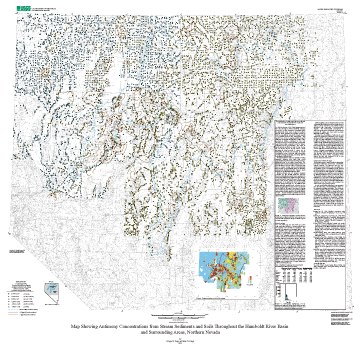
U.S. Geological Survey Miscellaneous Field Studies Map MF-2407-J
By Douglas B. Yager and Helen W. Folger
Version 1.0
The text of this report is presented here in Portable Document Format. The latest version of Adobe Acrobat Reader or similar software is required to view it. If you wish to download the latest version of Acrobat Reader free of charge, click here.
Text Only
PDF file (87 KB)
(This version of the report is accessible as defined in Section 508.)
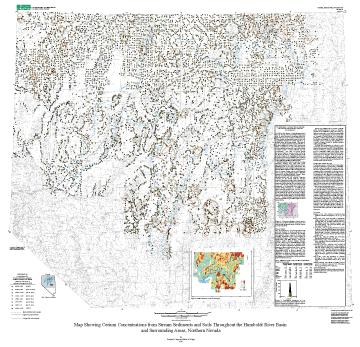
U.S. Geological Survey Miscellaneous Field Studies Map MF-2407-K
By Douglas B. Yager and Helen W. Folger
Version 1.0
The text of this report is presented here in Portable Document Format. The latest version of Adobe Acrobat Reader or similar software is required to view it. If you wish to download the latest version of Acrobat Reader free of charge, click here.
Text Only
PDF file (93 KB)
(This version of the report is accessible as defined in Section 508.)
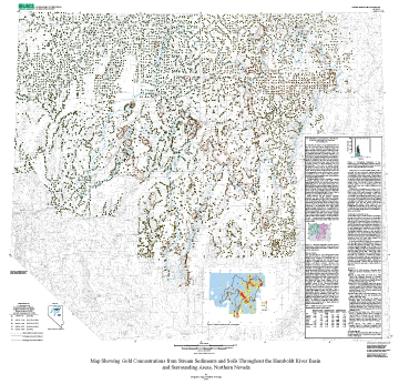
U.S. Geological Survey Miscellaneous Field Studies Map MF-2407-L
By Douglas B. Yager and Helen W. Folger
Version 1.0
The text of this report is presented here in Portable Document Format. The latest version of Adobe Acrobat Reader or similar software is required to view it. If you wish to download the latest version of Acrobat Reader free of charge, click here.
Text Only
PDF file (89 KB)
(This version of the report is accessible as defined in Section 508.)
U.S. Geological Survey Miscellaneous Field Studies Map MF-2407-M
By Douglas B. Yager and Helen W. Folger
Version 1.0
The text of this report is presented here in Portable Document Format. The latest version of Adobe Acrobat Reader or similar software is required to view it. If you wish to download the latest version of Acrobat Reader free of charge, click here.
Text Only PDF file (96 KB)
(This version of the report is accessible as defined in Section 508.)
Metadata:
Metadata TEXT file (20 KB)
Archived GIS files (not Section 508 accessible):
TARRED and GZIPPED ArcInfo files, metadata, etc.
(4 MB)
ZIPPED ArcInfo files, metadata, etc. (3.9 MB)