 |
|
|
| USGS Woods Hole Science Center |
Home Page / Synopsis / Introduction / Profile / Relationships / Salient Tendencies / Acknowledgments / Bibliography / Appendix
 |
 |
 |
 |
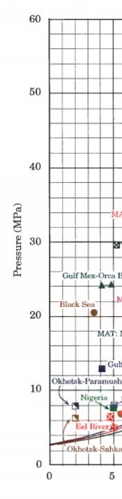
Figure 8. Relationship of estimated in-situ temperatures and pressures of methane hydrate samples to phase boundary. Ranges represent the temperatures and pressures from the uppermost and lowermost hydrate found on a specific site or, in the case of grouped surface samples (Eel River, Nigeria, Gulf of Mexico slope), the estimated variation in T and P over the area of sample recovery. Labels refer to sites listed in database (Appendix); MAT designation refers to Middle America Trench. Construction assumes that sediments are normally consolidated (no excess + pore pressures) and thus reflects hydrostatic pressures only. | |||
 [an error occurred while processing this directive]