Hawaiian Volcano Observatory
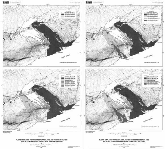
Flow maps (from sheets 1 and 2).
Pu‘u ‘Ō‘ō - Kūpaianaha eruption on the east rift zone of Kīlauea, which began in January 1983, is the longest-lived rift zone eruption of the last two centuries. By 1994, a broad field of lava, nearly 1 km3 in volume and 12 km wide at the coast, had buried 87 km2 of the volcano’s south flank. The initial six months of fissure eruptions (episodes 1-3) were followed by three years of episodic lava fountaining from the Pu‘u ‘Ō‘ō vent (episodes 4-47). In July 1986, after two days of fissure eruptions up- and downrift from Pu‘u ‘Ō‘ō (episodes 48a and 48b), the eruption shifted to a new vent, Kūpaianaha, 3.5 km downrift. For the next five-and-a-half years (episode 48), Kūpaianaha was the site of nearly continuous low-level effusion. The 49th episode occurred in November 1991, when several fissures opened between Pu‘u ‘Ō‘ō and Kūpaianaha (see Mangan and others, 1995, Bulletin of Volcanology, v. 57, p. 127-135). This three-week-long outburst was the result of the waning output of the Kūpaianaha vent, which finally died in February 1992 (see Kauahikaua and others, 1996, Bulletin of Volcanology, v. 57, p. 641-648).
The third epoch of the eruption began ten days later, when vents opened on the uprift slope of the Pu‘u ‘Ō‘ō cone. Several flank vents erupted over the next two years (episodes 50-53). In the first year, from February 1992 through February 1993, the low-level effusion was interrupted by 21 brief pauses. These ended with the beginning of episode 53 in February 1993, and for the next year, lava effusion was continuous. Episode 53 was ongoing at the end of the interval covered by this report.
During the years that Kūpaianaha was active, the Pu‘u ‘Ō‘ō conduit gradually evolved into a crater 300 m in diameter as the conduit walls collapsed. Beginning in 1987, an active lava pond was intermittently visible in the bottom of the crater; from 1990 on, the pond was almost continuously present. The Pu‘u ‘Ō‘ō pond drained at the beginning of episode 49 in November 1991, and the crater floor collapsed. Lava was visible in the crater by early December, and pond overflows resurfaced the crater floor, raising it to its former level of 35 m below the rim by the end of January 1992.
This report includes flow-field maps and a table giving a) start and stop times of the eruptive episodes and of pauses in the eruption, b) Pu‘u ‘Ō‘ō lava pond and crater-floor elevations, and c) elevations of the episode 50-53 vents and of the floors of the collapse pits that subsequently formed over these vents. A chronology of this interval of the eruption and an interpretation of the data included in this report can be found in Heliker and others (1998, Bulletin of Volcanology, v. 59, p. 381-393).
Download the text and table for this report as an 11-page PDF document (of98-103_text_table.pdf; 344 KB)
Download Sheet 1 of this report as a ~20" x 36" PDF (of98-103_sheet1.pdf; 28.7 MB)
Download Sheet 2 of this report as a ~20" x 36" PDF (of98-103_sheet2.pdf; 29.2 MB)
Download a 300-dpi JPG-5 file for both sheets at once as an ~21" x 36" PDF (of98-103_sheets_low-res.pdf; 5 MB)
For questions about the content of this report, contact Christina Heliker.
Download a copy of the latest version of Adobe Reader for free.
|
Help |
PDF help |
Publications main page |
| Western Open-File Reports for 2006 |
| Geologic Division |
Hawaiian Volcano Observatory
|

![]() U.S. Department of the Interior | U.S. Geological Survey
U.S. Department of the Interior | U.S. Geological Survey
URL: https://pubs.usgs.gov/of/1998/of98-103/
Page Contact Information: Michael Diggles
Page Last Modified: December 21, 2006