|
What is that Sinking Feeling? or Are We Slip-Slidin' Away?
Subsidence and Erosion in the Lake Pontchartrain Basin
Mississippi River sediment has formed most of Louisiana's coastal wetlands over the past 5000 years or more.
This happened when river water regularly deposited sediments over land areas during the river's annual floods, accumulating thick layers of sand, mud, and silt. Over time, a series of overlapping deltas formed, eventually building a wide deltaic plain that forms Louisiana's coast. Lake Pontchartrain was formed when Mississippi River deltaic deposits partially closed it off from the Gulf of Mexico. All the land in the Pontchartrain Basin south of Interstate 12 consists of Mississippi River sediments deposited over time. Fresh sediment is needed to nourish the wetlands vegetation and to insure the buildup of land. This was never a problem, because periodic flooding of the Mississippi River spread millions of tons of sediment across coastal marshes every year. This natural process of sedimentation might have continued indefinitely if it were not for human intervention.
The annual flooding caused problems for people who had settled along the river and its distributaries. This resulted in a system of flood control by building levees to help keep the Mississippi River, as well as rivers and bayous throughout the Lake Pontchartrain Basin, confined to narrow channels. While the levee system prevents damage to people and property, including loss of lives, it also prevents river water from flowing through the wetlands. The sediment that once nourished coastal marshes now flows directly into the Gulf of Mexico, where it sinks out of sight off the continental shelf.
Without the annual deposition of sediment from the Mississippi, most of Louisiana's coastal marshes are sinking, too. This is called subsidence, and it is a serious problem in the Lake Pontchartrain Basin. However, levees are not the only factor affecting sedimentation. The Mississippi River itself carries less sediment than it did many years ago, and much of its remaining sediment never reaches south Louisiana. Dams have been constructed on every major tributary of the Mississippi River, trapping sediment so it can't bring new life to coastal marshes. In addition, better farming practices in the Midwestern states prevent erosion of sediment from farmland, so less finds its way into the river.
Subsidence is a serious factor affecting the Lake Pontchartrain Basin, but coupled with sea level rise, it contributes to another problem, erosion. Even before levees lined the banks of the Mississippi River and its tributaries, Louisiana's coastal wetlands were being affected by the digging of ditches and canals through the marsh. First dug by trappers, hunters, and farmers for navigational purposes, larger canals were made by cypress loggers to remove big trees from our once-extensive forested wetlands. Scars from these operations are still visible in the LaBranche Wetlands and in the Manchac Wildlife Management Area near Turtle Cove. The majority of canals in coastal marshes, though, were dug by the oil industry for pipelines and access to drilling sites.
How do canals contribute to subsidence and erosion in the marsh? Spoil banks formed from the dredged material add weight to the spongy marsh soil, causing it to compact and subside. As it sinks, "ponding" occurs, or the formation of large areas of open water in the marsh. Over time, the canals widen, and more wetlands are converted to open water. These factors change the hydrology, or water flow, in the wetlands, preventing much-needed sedimentation and allowing saltwater to intrude farther and farther inland. Freshwater marsh vegetation cannot tolerate these environmental changes and, as it dies, the soil weakens and is subject to erosion by tidal action and severe storms. Shoreline erosion in some areas is greater than 100 feet per year.
In the Lake Pontchartrain Basin, the most dramatic effect of saltwater intrusion can be witnessed at the navigational ship channel known as MRGO, or the Mississippi River Gulf Outlet. Cutting through both fresh and brackish coastal marshes of lower St. Bernard Parish, as well as areas of forested wetlands, the MRGO has contributed in a major way to existing subsidence and erosion problems. Ponding has left a swath of damage threatening St. Bernard and Orleans parishes that will take many more years to repair the damage than it did to create it.
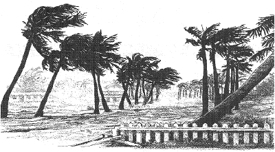
As sea level rise exacerbates problems associated with subsidence and erosion, areas of the Basin especially affected by those factors are the barrier islands, such as the Chandeleur Islands. Formed by the same coastal processes that build wetlands, these fragile fringes are slowly disappearing. While serving to protect the coast from severe storms and hurricanes, barrier islands bear the brunt of such storms. Barrier islands also provide important habitat for marine life. Yet, they are deteriorating faster than natural processes can rebuild them. Sea level rise is slowly flooding the islands, sedimentation remains low, and recent storms have contributed severe erosional damage. Without our barrier islands, the factors associated with global climate change will wreak even more havoc on the fragile coastal marshes.
Human intervention has unintentionally created these problems, and it will require human intervention to do something about them. Several projects already at work are in the experimental stages, and it will be interesting to follow their progress as we hope for positive results in rebuilding wetlands in the Lake Pontchartrain Basin. Mitigation projects have filled in existing pipeline canals and areas of open water in the LaBranche wetlands. Rock dikes near Martello Castle in Lake Borgne and between Lakes Maurepas and Pontchartrain are helping to prevent further erosion. Every year, thousands of Christmas trees are placed in the marshes of Orleans, St. Bernard, Jefferson, St. Tammany and St. Charles parishes, where they serve to slow down erosion from wave action and to trap sediment.
Proposed river diversion projects are being suggested to rebuild our wetlands. These are ambitious projects, costing many millions of taxpayer dollars. Will they be worth the cost? Can we afford to do it? Will they work? Scientists are in heated debate about these projects, as more solutions to our wetland loss problem are being sought.
You can find more information on global climate change and how it affects coastal wetlands in these excellent resources:
(1) Project TELLUS Teaching Modules for Global Change Issues (Lyle Soniat, Ph.D., Sea Grant Education Office, LSU, Baton Rouge, LA 70803)
(2) Global Environmental Education Resource Guide (Sharon Walker, Ph.D., Gulf Coast Research Laboratory P.O. Box 7000, Ocean Springs, MS 39566-7000)
|