
| imagery |
| bathymetry |
| samples |
| geologic interpretive coverages |
Raster DataThere are four raster image files contained on this disk. All the images are stored in 8-bit geotiff format and have an approximate 4-meter pixel resolution. The images may be retrieved or viewed (assuming your web browser has a 'tiff' image viewer associated) by selecting the appropriate file name. Although some programs do not interpret the additional geotiff tags, the image may still be viewed by any program capable of viewing a 'tiff' image. For those software packages that do not process the geotiff tags properly and where the user wishes to georeference the images, a separate georeference report, which contains the necessary information, is available for each image.
Supporting metadata and spatial georeferencing information for the individual files are supplied from the additional information column. The geotiff images and the associated geoference reports may be found in directory data/imagery from the top level of this CD-ROM.
| Filename | Description | Additional Information |
| compos.tif | Completed sidescan sonar mosaic with black background. | Metadata
georeferencing report ESRI world file |
| ssair.tif | Completed sidescan sonar mosaic integrated with aerial photograph of Sarasota, Florida. Imagery is displayed on white background. | Metadata
georeferencing report ESRI world file |
| bathy1.tif | Bathymetry image of study area. Bathymetry shown in a gradiated pseudo-color table. | Metadata
georeferencing report ESRI world file |
| bathy2.tif | Bathymetry image of study area. Bathymetry shown in a stepped pseudo-color table. | Metadata
georeferencing report ESRI world file |
GRID DataTwo of the four raster images on this disk are also archived in ESRI's "grid" format. These "grid" files represent the composite sidescan sonar mosaic (compos.tif) and the bathymetry image (bathy1.tif). The purpose of archiving these two images as GRID files was to satisfy ESRI's view of differentiating grids and images. Though both are defined with a raster structure, the grid files are considered 'cell' based. This means that each grid cell unit (i.e. pixel) is a discrete, uniform unit that is referenced by its geographic x,y location. In addition to their spatial location, each grid 'cell' corresponds to a specific characteristic of that site, such as acoustic reflectivity for the sidescan sonar mosaic or depth for the bathymetry.
More important though, the value of these files being in the grid format is to allow spatial modeling and analysis with the ESRI GRID geoprocessing system and Spatial Analyst suite of programs. Though the user could possibly convert the imagery to a grid file, the conversion was done as a matter of convenience. As part of the conversion, cells with a value of zero were tagged as NODATA.
The files comprising the GRID coverages have been archived together and may be retrieved by acessing the zip file.
GRID DATA Description Grid Files sidescan mosaic - the compos.tif image converted to an ARC/INFO grid. See the image file for metadata information. zip file bathymetry - the bathy1.tif image converted to an ARC/INFO grid. See the image file for metadata information.
zip fileData Directory: data/grids
There are three major sets of vector data archived on this disk. These data sets are comprised of:
The vector data are stored in various sub-directories under the
"data"
directory at the top-level of this CD-ROM, and the data sets may be retrieved
from the CD-ROM by a web browser. For more information on how to
download a data set, click here.
These data files are for use in Geographical Information Systems (GIS)
for analysis and integration with other geospatial data. Generally
the vector data may not be viewed as spatial data by any web browser, but
some data sets (bathymetry contour lines and sample information) have been
stored here in a simple ASCII data format, and those files may be directly
viewed through a web browser. To view the data in it's spatial domain,
you must have an appropriate viewer, such as ESRI's ArcView or ArcExplorer,
on your computer system. That viewer must be configured to work with
your WWW browser, the data can be accessed using the appropriate
software from outside of the WWW browser environment, and download the
selected data by pointing your viewer to the appropriate directory
and file. For more information regarding data viewers and software,
see What You Need! from the
Introduction
to GIS page.
The vector data (also referred to as the coverages) has been archived in ESRI's ArcView shapefile format. These coverages can be viewed with a variety of programs including ESRI's ARC/INFO, ArcView, their free GIS viewer, ArcExplorer, and PCI Remote Sensing Corporations freeware image handler.
To locate a specific coverages, please browse the tables provided below. There is one table per coverage category with individual entries per layer. Links to the separate ArcView shapefiles for each data layer are available. Because one of the purposes of this CD-ROM was to archive the data for future studies and possible inclusion to other GIS applications, all the file components of the individual coverages are archived on disk. If you desire to download a coverage from the CD-ROM to disk, please download all the files listed under the "ArcView Shapefiles" heading to the same directory.
To aid in locating the data from outside of the web browser environment, a Data Directory entry is included in each of the tables. This entry reflects the directory from the top level of this CD-ROM where the data coverages may be found.
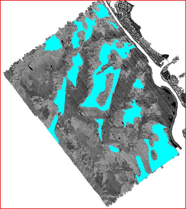
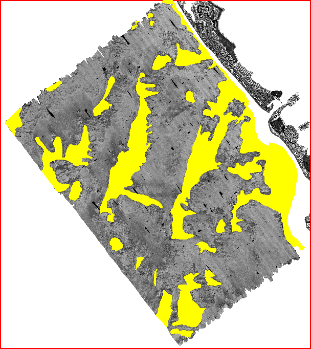
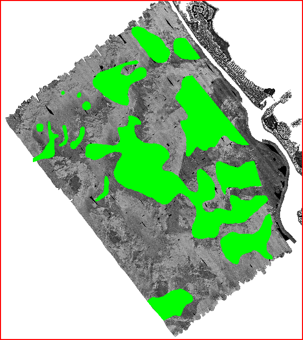
Images (browse graphic) showing the extent of the individual
data coverages have been overlaid on the integrated sidescan sonar mosaic
and air photo (ssair.tif) image.
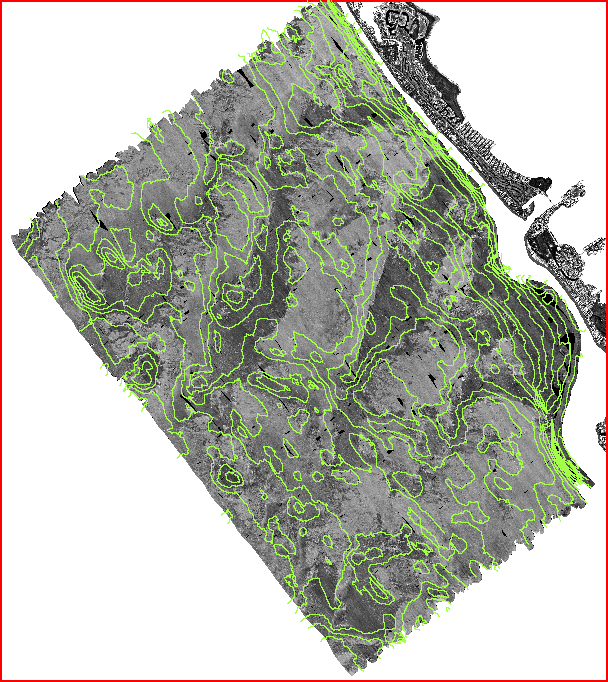
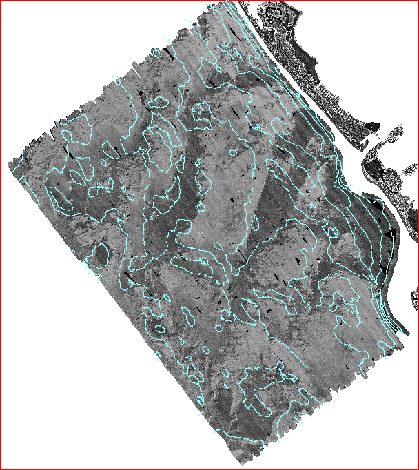
Bathymetric contour lines
There are two sets of contours lines for the study area. These contour data sets were derived from the bathymetry image and cover the area from 3.5 to 12 meters offshore. One dataset contains contours at one meter interval while the second set contains contours at a half meter interval. The attribute information for the contours lines are stored in decimeters. For example, an attribute value of 85 would translate to a depth contour of 8.5 meters.
| Description | ArcView Shapefiles | ASCII |
half meter
metadata |
halfm.dbf
halfm.shp halfm.shx |
halfm |
one meter
metadata |
meter.dbf
meter.shp meter.shx |
onemeter |
| Data Directory: | data/contours/halfm
data/contours/onemeter |
data/contours/halfm
data/contours/onemeter |
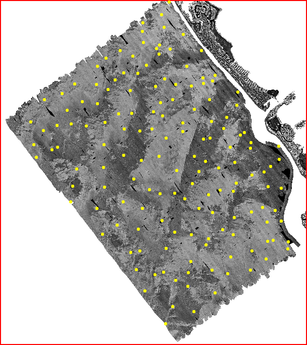
Samples
A total of 152 grab samples were collected while the cruise was underway. These samples were later analyzed by Eckerd College, St. Petersburg, Florida. The samples are available as ESRI ArcView shapefiles, and in a simple ASCII format. The associated metadata file contains a list of attributes. Sample locations are recorded in decimal degrees.
| Description | ArcView Shapefiles | ASCII |
Samples -
HTML
table
metadata |
samples.dbf
samples.shp |
samples |
| Data Directory: | data/samples | data/samples |
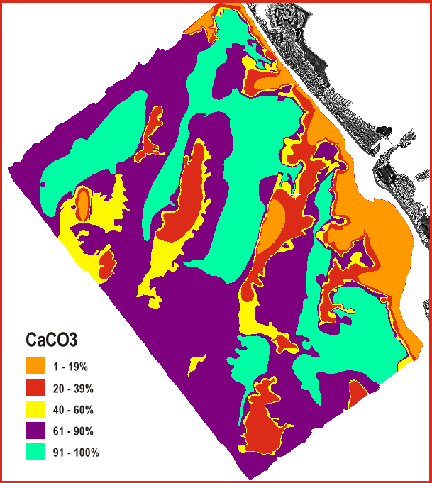
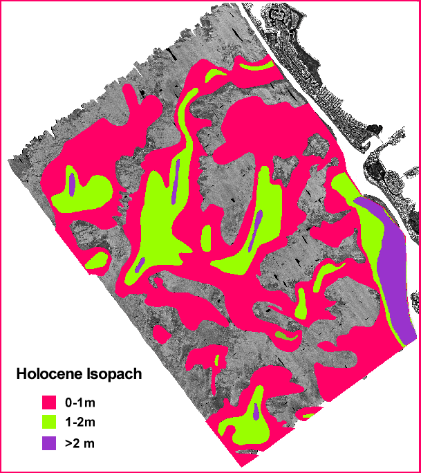
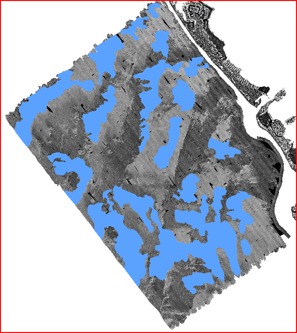
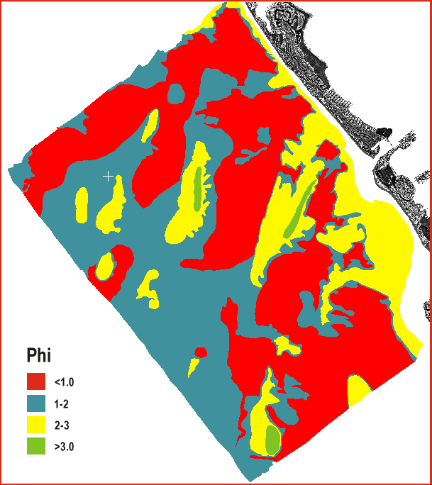
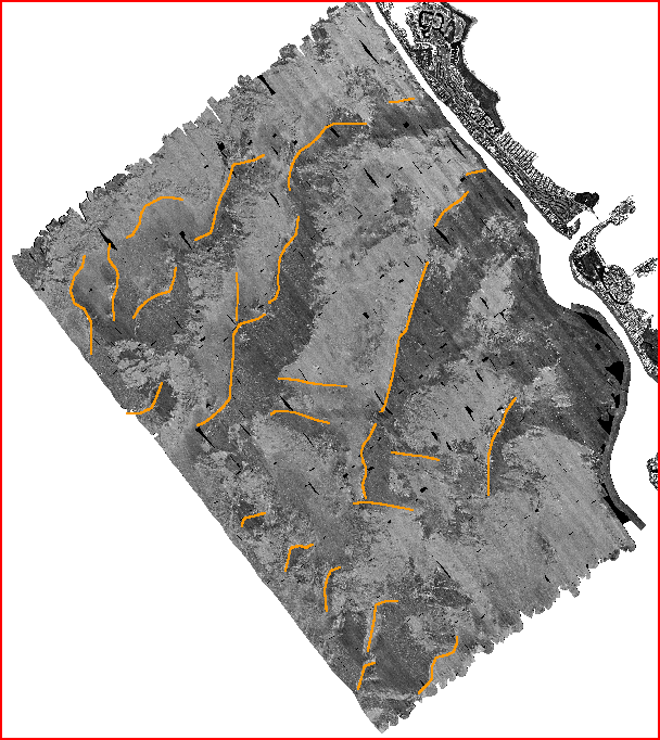
Geologic Interpretive Coverages
Geologic interpretations of the near-surface seismic facies and stratigraphy of the study area were created by the senior author, David Twichell, by interactively drawing bitmap graphics or vector polygon outlines over the sidescan sonar mosaic and saved in the PCI image database. These overlays were then exported and included in the ArcView GIS.The geologic interpretive overlays are available as ArcView shapefiles. If you wish to copy the ArcView shape files to disk, please note that you must copy all the listed files to the same directory.