
Three Dimensional Views of P-wave Tomography
The results from local earthquake, P-wave tomoography can be viewed as a set of vertical cross-sections or horizontal depth slices. We have found that the best visualization of the complex results is achieved using a combination of velocity isosurfaces and fence diagrams. In the following web pages, we use an isosurface generated at 7.5 km/s as a base to plot the cross-sections and fence diagrams. When the start button below is pressed, the series of images will be started. You can control the image display by selecting one of the First, Prev, Next, or Map buttons on the left of the images. The sections and isosurface are displayed looking northwest across western Washington, with x=north, y=east, and z=down. The x and y axes are in grid indexes (with each grid interval representing 8 km). The z axis is scaled in depth (km). Due to the complexity of the models we have tried to maintain the maximum resolution compatible with reasonable download times for the images. By pressing the 'Map' button you can jump to the grid map for a more precise location of each cross-section. The grid number for each section is labeled on the image, since the scales of the 3D display cannot be easily utilized. Interpretations shown by text below the images is under construction and are not final, but are provided to guide the user in possible geologic significance of the results.
To start looking at the 3D images in sequences, click on the eye:
To go directly to images and text for the most important 3D tomographic details, click on the following icons:
Return to:Subduction Zone Dynamics Intro | PACNW | Earthquake Hazards | Central Region | USGS
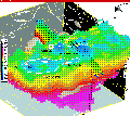 Sedimentary basins
and Seattle fault zone details
Sedimentary basins
and Seattle fault zone details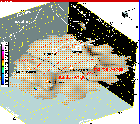 Arch in the Juan
de Fuca plate and mantle wedge
Arch in the Juan
de Fuca plate and mantle wedge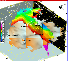 East-west cross-section
through Seattle and Seattle Basin
East-west cross-section
through Seattle and Seattle Basin North-south
cross-section through highly compressed prism
North-south
cross-section through highly compressed prism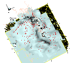 Overhead
view of Juan de Fuca plate arch and dip directions
Overhead
view of Juan de Fuca plate arch and dip directions View of OWL,
crustal buttress, and mantle wedge from large model
View of OWL,
crustal buttress, and mantle wedge from large model