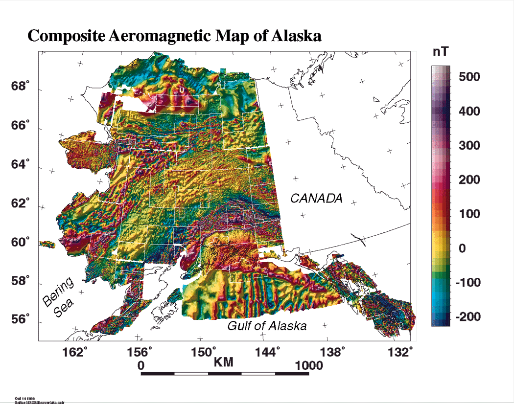
This is the composite aeromagnetic map of Alaska. For this compilation we did a minimum of digital processing to each individual survey and left a bit of white space between the individual surveys. You can see a richness of geologic and tectonic detail at a range of scales. Southern Alaska has arcuate bands that parallel the modern volcanic arc. Northern Alaska has more subdued, generally equidimensional magnetic features. Central Alaska has a rich texture of short-wavelength features on a generally neutral magnetic background.
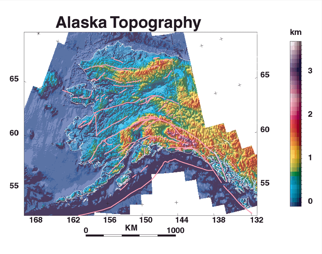
This is a shaded relief image (illumination from the northwest) of a 3-arc-minute digital elevation model (DEM) for Alaska. This image is included here to provide geographic reference for the geophysical maps. Southern Alaska is dominated by the arcuate Alaska Range, northern Alaska by the smaller Brooks Range. West-central Alaska has generally low elevations and only rolling relief. The geology of west-central Alaska is generally obscured by surficial sediment and vegetation cover. North of the Brooks Range in northern Alaska lies the Arctic coastal plain, also called the North Slope. The pink lines are major faults.
We have put together a broad tectonic interpretation of these aeromagnetic data grids. See this issue of GSA Today (Saltus and others, 1999) to read about it.
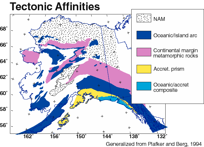
Tectonically speaking, Alaska is a complex and poorly understood place. Southern Alaska is composed of a series of arc-parallel terranes of oceanic affinity. Northern Alaska has North American (NAM) continental affinity and is blanketed by a thick sedimentary sequence. Central Alaska has a heterogeneous tectonic map pattern and is also obscured in large part by surficial deposits.
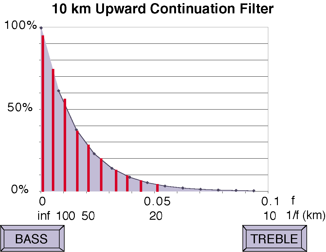
This graph depicts the effect of the upward continuation filter. You can picture this as the readout diodes on some graphic equalizers in high-end stereo systems. The graph shows that for a 10 km upward continuation, anomalies with a 100 km wavelength (bottom row of numbers) are attenuated by about 45%. Anomalies with wavelengths smaller than 20 km are attenuated by more than 95%. It is like cranking up the bass on your stereo to hear more of the tubas and less of the piccolos.

To help us focus on the deep, crustal-scale features in the magnetic compilation, we have upward continued the merged aeromagnetic compilation by 10 km. Actually we did a range of upward continuations, but 10 km seems adequate to eliminate much of the shallow crustal signal. Another advantage of using this upward-continued map for regional interpretation is that it severely reduces the visible contrasts related to original survey flightline spacing. This allows for confident recognition of regional trends and features.
In Southern Alaska the arcuate, laterally continuous, deep magnetic features correlate spatially with the mapped oceanic arc affinity terranes (as we would expect).
In Northern Alaska the general background of broad magnetic lows are what we expect given the thick sedimentary cover. The huge North Slope magnetic high (which was surveyed as part of the original 1945 NPRA survey) is enigmatic. The amplitude and wavelength of this deep magnetic high combined with the lack of any suitable source rocks in the drilled portions of the sedimentary section, requires a deep, voluminous, and highly magnetic source. Travis Hudson and I propose that this represents mafic rocks in a failed continental rift, possibly of Devonian age (Saltus and others, 1999).
Central Alaska has a generally average continental magnetic level punctuated by a series of relatively small and discontinuous deep magnetic highs. These highs have a hit and miss correlation with mapped tectonic units; some of the highs correlate with mapped Cretaceous and Tertiary igneous rocks. Should we look to the south or north for an understanding of these features?
In our GSA Today article (Saltus and others, 1999), we make the case that these central Alaska features may have more similarity to features to the north. We speculate that these isolated magnetic highs represent collapsed fragments of an ancient rift basin analogous to the Umiat basin that overlies the northern Alaska deep magnetic high. This is somewhat counter to the prevailing view that postulates a generally more oceanic affinity for this portion of Alaska.
At any rate, we hope that our interpretation will stimulate discussion and further work to sort out this fundamental issue. Of particular interest to us is understanding the region of the data gap in the southwestern part of the NPRA. This is an area of exploration interest for both minerals (Red Dog - largest zinc mine in the world) and hydrocarbons (new work by Alaska State geologists). The data gap makes it difficult to evaluate the structural connection (if any) of the narrow magnetic high that appears to connect across the data gap (which lies above mafic and ultramafic rocks that are inferred to be allochthonous) to the deep (autothonous) feature we have interpreted as a source for the North Slope deep magnetic high. We would like to see new aeromagnetic data collected in this region to address these issues. We also feel that a deep continental drillhole into the North Slope deep magnetic high could yield some exciting and fundamental constraints for tectonic interpretation in northern Alaska.

This figure shows the magnetic domain boundaries (thick red lines) that we have defined based on the 10 km upward continued magnetic map. In southern Alaska these domains are laterally continuous over great distances and parallel the modern arc boundary. In northern Alaska a generally quiet magnetic zone is host to a single large amplitude, long-wavelength magnetic high. Central Alaska is mostly of neutral magnetic character punctuated by discontinuous pieces of magnetic highs. The north-south line shows the location of the south-to-north interpretive profile model shown in a later slide.

This figure shows the regional magnetic domains with color coding to distinguish regional zones (Pacific Ocean - PAC, Interior Alaska, Northern Alaska), deep highs, intermediate highs, and major magnetic troughs.

In this figure we show the offshore extension of the southern Alaska magnetic domains westward onto the Bering Shelf. The Bering Sea data are from Godson (1994). The dashed line shows the 250 m depth contour. The heavy blue lines show the extension of the southern Alaska deep magnetic high and its adjoining troughs. When taken together with its southeastern extension, this magnetic domain can be defined continuously for more than 2,500 km.

Here is a 2-dimensional, regional magnetic model that spans Alaska from south to north (location given on the upward continuation boundary map a few slides back). Note that there is a 10 to 1 vertical exaggeration in this display. Magnetic susceptibility values are given in SI units times 1000 (i.e. the southernmost block has an SI susceptibility of 0.005).
The oceanic terranes in the south produce very large amplitude magnetic highs. Central Alaska background levels are nicely matched by continental-type magnetizations. The Northern Alaska deep magnetic high can be modeled by 10-km-thick mafic body at the base of the Umiat basin. The darker colors (purples) indicate higher (oceanic) magnetizations, lighter colors (pinks) indicate lower (continental) magnetizations.

This slide depicts another way of filtering the aeromagnetic data to emphasize regional features and trends. The data have been converted using the pseudogravity transform (Baranov, 1957). This mathematical operation converts the magnetic data to the analogous gravity field that would be observed if density varied proportionately with the magnetic intensity of the rocks. Long-wavelength trends in this data view are susceptible to distortion if there are spurious long-wavelength trends in the merged magnetic data. It is generally encouraging that the trends and features in this data view support the definition of regional magnetic domains that we made from the upward-continued data.

This slide depicts isostatic residual gravity data spanning Alaska (Barnes and others, 1994). These data are sensitive to lateral rock density variations in the upper 10 km or so of the crust. Most gravity lows, including the major low over the Cook Inlet in the center of the southern part of the map, are caused by low-density sediments in surficial basins. Arcuate highs along the southern margin of Alaska probably reflect mafic and ultra-mafic rocks in the shallow part of the magmatic arc. Interior Alaska is gravitationally neutral, consistent with the neutral magnetic signature there. Northern Alaska has a generally low magnetic signature caused by the thick Mississippian and younger sedimentary section there. However, the gravity values are not as low as one would expect (from the thickness of the basin as known from seismic data), particularly over the deepest parts of the basin, reflecting the presense of anomalously dense (mafic?) rocks in the pre-Mississippian basement.

This is a conclusion slide from a presentation at the 1998 Fall Geological Society of America meeting in Toronto (NAM = North American Plate affinity rocks). We encourage you to grab our dataset off the web and use it to constrain your geologic thinking and modeling. We think regional magnetic compilations are an essential ingredient for establishing regional geologic and tectonic framework. We find that the regional magnetic data for are Alaska are consistent with a "non-suspect" nature (i.e., North American crustal affinity) for most of Alaska north of the southern margin.