|
||||||||||||||||
| Offshore Sand and
Gravel Resources on the Insular Shelf of Puerto Rico
Kathryn M. Scanlon modified from USGS Open File Report 98-38 |
||||||||||||||||
|
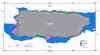
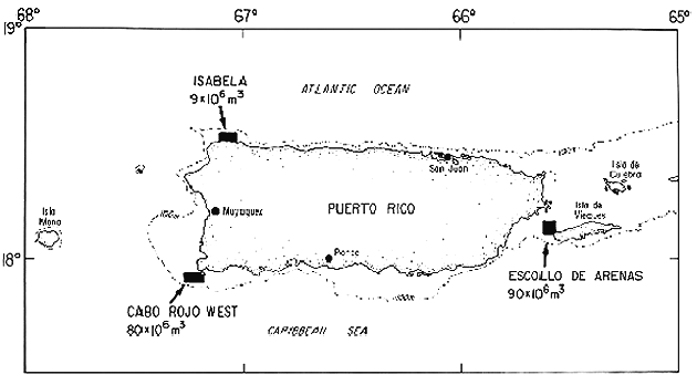
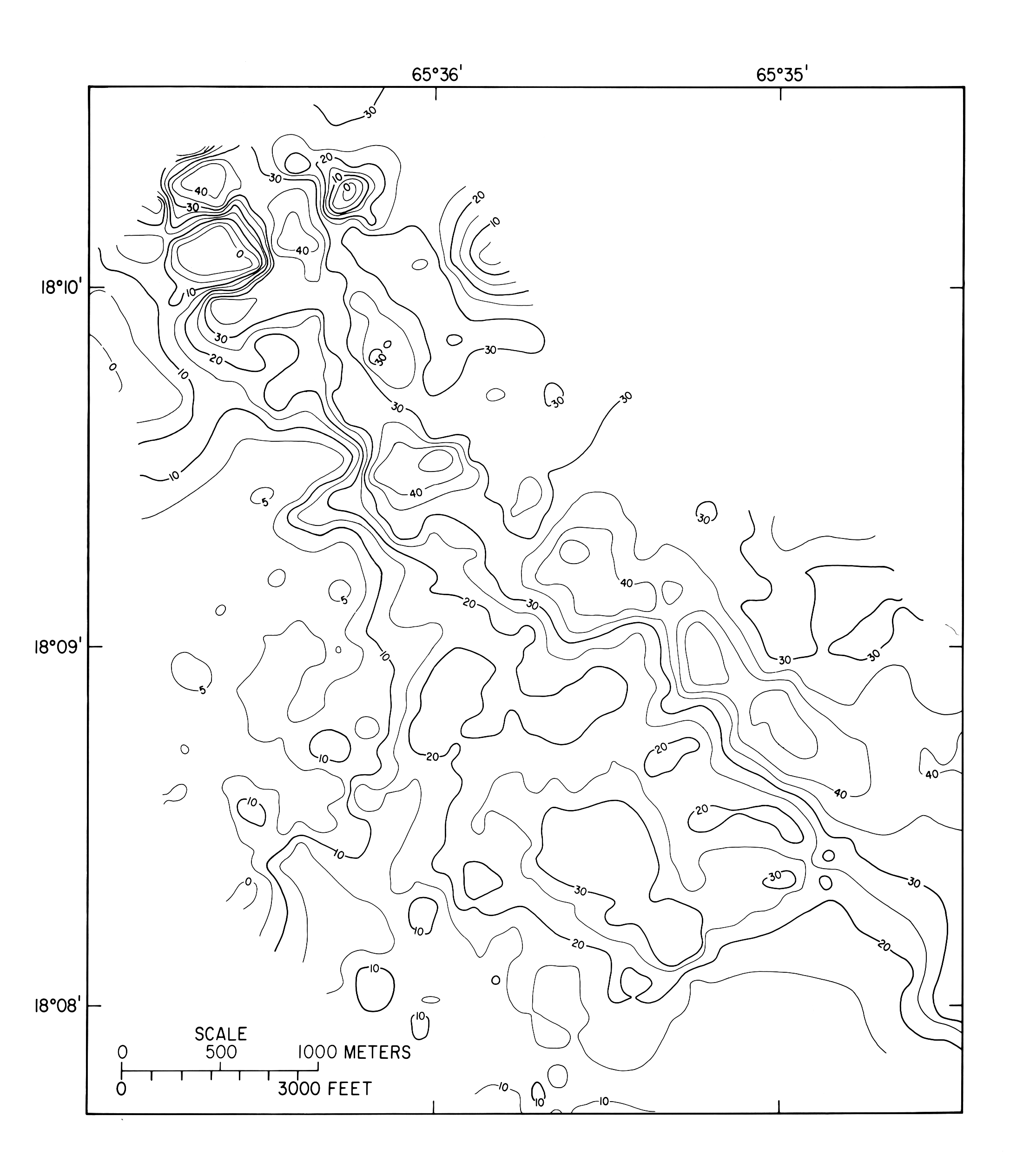
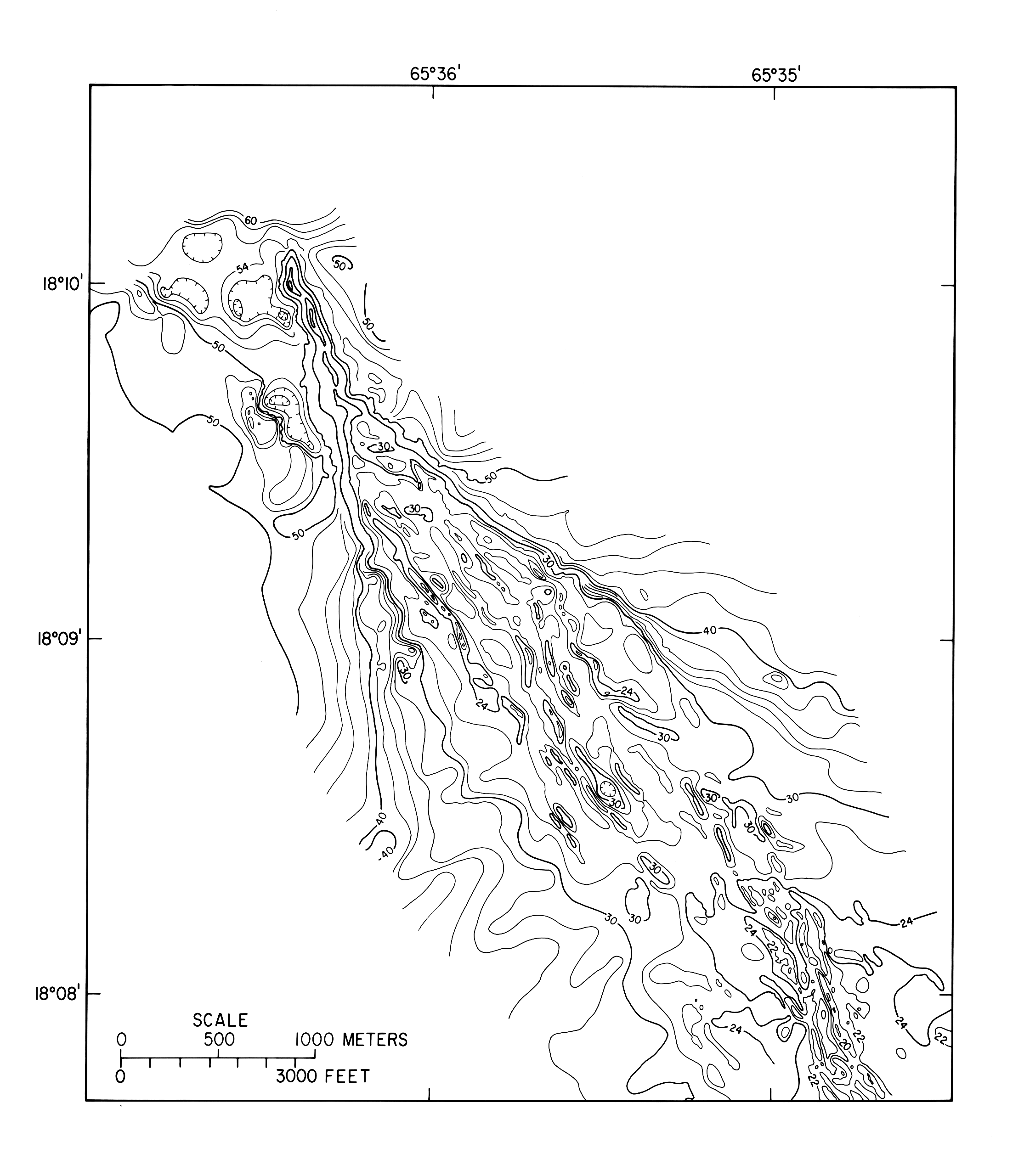
Summary Three potential sites for mining of sand and gravel from the insular shelf are considered: Escollo de Arenas (off the western end of Vieques), Isabela (northwest shelf), and Cabo Rojo West (southwest corner of Puerto Rico). At these locations large accumulations of sand, fed by longshore currents, have been identified. Of the three sites, the Escollo de Arenas appears to be the most promising for offshore mining. Surficial Sediment Map This map showing types of surficial sediment (map 1) is highly generalized and should be considered as a starting point, a base map for more focused studies. The U.S. Geological Survey (USGS) is currently mapping the geology of the insular shelf of Puerto Rico in more detail (scale 1:40,000). Most of the maps in the series have been published (Rodriguez and others, 1977; Beach and Trumbull, 1981; Grove, 1983; Pilkey and others, 1987; Trias, 1991; Rodriguez and others, 1992; Morelock and others, 1994 see fig. 1) or are in press (Rodriguez and others, in press; Schlee and others, in press; Scanlon and Trias, in press; Scanlon and others, in press; Trias and Scanlon, in press; Trias and others, in press; see fig. 1). Four additional maps, covering the shelf east of Puerto Rico and surrounding Culebra and Vieques, are in preparation. The published maps and the data collected for the maps in preparation (Scanlon, unpublished data) have been used in the present study. Methods To produce this map of surficial sediments on the insular shelf of Puerto Rico, the many sediment types were grouped into three very general categories: high calcium carbonate, low calcium carbonate (terrigenous), and mixed (carbonate and terrigenous). This was done to establish a common denominator for the differing types of data compiled from numerous sources. Data from more than 2500 samples, from over 35 separate studies, were compiled to create this map. The type of data available varies from study to study. Calcium carbonate analyses and complete grain size data are available for some sets of samples; only field descriptions are available for other sets. Unpublished theses are a major source of data (Beach, 1975; Bush, 1977 and 1991; Grove, 1977; Fernandez, 1978; Grossman, 1978; Fuerst,1979; Rodriguez, 1979; Stout, 1979; Anderson, 1981; Lincoln, 1981; Prehmus, 1981; Brackett, 1985; Benes, 1988; Lightner, 1988; see fig. 1). Previously published maps were used as guides in areas where sample localities are sparse. Although the quantity of data varies, high-quality data are available for localities throughout the map area. Schneidermann and others (1976) is the only previous attempt to map the surficial sediments of the entire shelf of Puerto Rico, but since it is based on rather sparse data, we used their map only where no other data exist. Where carbonate analyses are available, we used 25 percent and 75 percent CaCO3 as the lower and upper limits, respectively, of the "mixed" sediment type. These limits were chosen because most of the previously published studies of Puerto Rico shelf sediments used these numbers. A sample containing more than 75 percent CaCO3 is classed as carbonate; a sample containing less than 25 percent CaCO3 is classed as terrigenous. Where only descriptions are available, we classified the samples on the basis of color, texture, and major constituents mentioned. We also took into account the local environment and descriptions and analyses from any similar samples from nearby. Where published maps showing types of sediments are available, but not including data for individual samples, we used the description for each mapped unit to categorize all the samples contained therein. Discussion As one might expect, the map shows that terrigenous sediment deposits are associated with the mouths of major rivers. This is particularly evident on the north side of the island where rainfall and, consequently, runoff are greatest. Rio Grande de Loiza, which drains Sierra de Luquillo, where annual rainfall approaches 200 in. (Calvesbert, 1970), has a large deposit of terrigenous sediments near its mouth. Rio de la Plata and Rio Grande de Manati also exhibit localized terrigenous sediment deposits. On the western part of the north shelf, the terrigenous deposits merge in a continuous band. Pockets of terrigenous sediment are also present on the south shelf, both at the mouths of rivers (for example, Rio Guayanilla and Rio Tallaboa) and in the protected areas behind reefs (for example, near Jobos; see map 1). The shelf east and southeast of Puerto Rico is dominated by carbonate sediment. Small patches of terrigenous or mixed sediment are found along the coast near the mouths of rivers. The rivers in southeastern Puerto Rico have a small drainage area in comparison with those that empty onto the north shelf and would not be expected to create large terrigenous deposits (Wilson and Iseri, 1969). An elongate sand shoal of mixed terrigenous and carbonate sediment extends northwest from the western end of Isla de Vieques. Areas where the shelf is wide, and therefore extends beyond the direct influence of rivers, are dominated by biogenic sands having a high carbonate content. This can be seen particularly on the southwest shelf, on the Virgin Islands Platform east of Puerto Rico, and the south-central shelf. Not surprisingly, mixed sediment deposits are generally found between areas of predominantly terrigenous and predominantly carbonate sediment, such as off the west coast of Puerto Rico and near Isla Caja de Muertos on the south shelf. Offshore Sand and Gravel Introduction Sand and gravel are important commodities in Puerto Rico because of their use as aggregate for concrete, in road construction, as fill, and for beach replenishment. Decades of industrial growth in Puerto Rico have increased the demand for sand and gravel. During the 1950's and 1960's this demand was often met by mining beaches and dunes. In the late 1960's, the importance of the beaches and dunes, both as sources of tourist revenue and as natural protection from high seas, was recognized and Federal and Commonwealth legislation was enacted to prohibit or greatly restrict their destruction. But, like many island nations, Puerto Rico has discovered that the sand and gravel available on the island will not supply all its future needs. Since the cost of transporting this bulky commodity is high, it is expensive to import. Nearby sources that can be mined while avoiding unacceptable environmental impact are needed. A potential solution may be found under water, on the insular shelf. Offshore sand and gravel are mined elsewhere. For example, the United Kingdom, the Netherlands, Denmark, and Japan have well-established marine-mining industries, which satisfy nearly 20 percent of their sand and gravel needs (Williams, 1986). Factors affecting the feasibility of mining of sand and gravel on the insular shelf of Puerto Rico are of three types: technological, economic, and environmental. The technology exists to carry out large-scale mining in water as deep as 30 m (Williams, 1986). Other factors affecting technological feasibility are speed of the current and frequency of high seas. The ideal site should be protected from the prevailing winds and should not have strong currents. Economic considerations include transportation distances and the characteristics of the deposit. Williams (1986) gives 50 km as a rule of thumb for maximum haul distance, but this number should be based on local costs for transporting the sand and gravel by barge. Transportation distances from port to the site of where the sand and gravel will be used should also be considered. The characteristics of a deposit that make it attractive include a large volume and a low percentage of fine sediment. It is also important that the deposit be thick and that the material underlying it not be mud or other fine sediment. Thalassia sea grass beds tend to trap fine sediment and can render an otherwise economic deposit too ‘dirty’. Environmental considerations are both biological and geological in nature. Direct impact on the biota of the deposit needs to be evaluated, as well as indirect impact, such as the effects of suspended sediment on nearby reefs. Changes in the shape of the sea floor can alter local wave and current action (Cruikshank and Hess, 1975), which can cause an increase in erosion of nearby beaches. It would be sadly ironic if the mining of offshore sand for beach replenishment actually caused additional beach erosion. A more complete discussion of biological and geological impacts that would result from offshore dredging in Puerto Rico can be found in Cintron and others (1984). Definitions and standards The terms "sand" and "gravel" are grain-size classes of rock particles and do not imply a particular composition. Several scales for describing grain size are in current usage (Folk, 1974). In this report, sand grains range from .0625 mm to 2 mm in diameter; gravel includes the size classes "granule" and "pebble" and is between 2 mm and 64 mm in diameter. In the real world, deposits may contain a mixture of grain sizes and are described by compound names such as "muddy sand" (a deposit that is predominantly sand, but has a finer grained component). There is little difference between sand and gravel mined on land and that taken from a submarine source. Impurities such as salt or organic material can easily be washed from the marine sand and gravel if necessary. Industry requirements for grain size, grain shape, sorting, and composition vary widely and depend partly on the intended usage. Although published standards exist, they are not universally followed (Williams, 1986). In general, terrigenous (that is, non-carbonate) deposits are preferred for construction purposes, whereas carbonates are used as a source of lime (Cruickshank and Hess, 1975). Replenishing beach sand with sand that matches the existing sand is important for both aesthetic and practical reasons. Sand that is too fine may be winnowed away quickly; that which is too coarse may be more stable, but may produce a steeper shore profile (Williams, 1986). Material that is much too coarse may not return to the beach if it is shifted offshore during a storm. Discussion of potential for sand and gravel Grove and Trumbull (1978) identified three offshore sand deposits that, on the basis of a preliminary study, showed potential for offshore mining. The three sites are Escollo de Arenas (off the western end of Vieques), offshore of Isabela (northwest shelf) and Bahia Sucia (east of Cabo Rojo). In a later study, Cintron and others (1984), after evaluating 23 sites on the insular shelf of Puerto Rico for their potential as sources of sand and gravel, also identified Escollo de Arenas and Isabela as sites that deserved further study. They eliminated the Bahia Sucia site (on the grounds of biological sensitivity and potentially severe coastal erosion if mined) and added Cabo Rojo West (on the shelf southwest of Cabo Rojo) as a favorable site. The three most promising areas (Isabela, Cabo Rojo West, and Escollo de Arenas) are discussed below. Isabela The Isabela area is on the north insular shelf of Puerto Rico, at the westernmost end of the island, where the shelf widens from less than 4 km to about 6.5 km (fig. 2). The water depth in the deposit area is between 20 m and 45 m. The sediment is predominantly carbonate, and terrigenous river-derived sediments are confined to a narrow strip parallel to the coast (map 1). Fine-grained material is present in these river sediments and in deep-water deposits beyond the shelf edge (>80 m), but the carbonate sediments on the middle shelf are relatively free of fines (Cintron and others, 1984; Trias, 1990). The first known study to evaluate the Isabela area as a potential source of sand and gravel was conducted in 1973 by Borinquen Minerals, Inc., a local mining company. They estimated a sand volume of between 20 and 25x106 m3 (Cintron and others, 1984) and requested a permit to dredge. No seismic-reflection profiles were collected (Trias, 1990). Two subsequent studies (Grove and Trumbull, 1978; Grove, 1983) discussed the composition and texture of the surficial sediments. Grove (1983) showed line drawings of two shallow-penetration seismic-reflection profiles across the shelf in the Isabela area, but they are of little value in estimating the volume of sand. A study by the USGS (Trias, 1990) estimated that the volume of sand and gravel at the 30-km2 Isabela site is 8.7x10⁶ m3, less than half of the volume previously suspected by Borinquen Minerals, Inc. (Cintron and others, 1984). Trias (1990) based his estimate on more than 100 line-km of well-navigated, high-resolution seismic-reflection profiles in a grid having approximately 500-m spacing between lines. He concludes that the Isabela offshore sand deposit is economically unattractive for three reasons. First, the volume is relatively low, and the deposit is thin and patchy (fig. 3). Second, most of the sand is in deep water (30-45 m), and would be expensive to recover. Third, the area is unprotected from the prevailing northeast winds and is prone to rough seas. Cabo Rojo West Cabo Rojo is a promontory of land on the southwest corner of the island of Puerto Rico. The Cabo Rojo West sand deposit is 1-6 km west and southwest of Cabo Rojo in water depths of 10-20 m (fig. 2). Except for a pocket of mixed terrigenous-carbonate sediments adjacent to the west side of Cabo Rojo, the sediments of this area are predominantly carbonate (map 1). Previous work in the area consists of a Master's thesis (Fernandez, 1978) and a USGS report by Shideler (1980), both of which dealt with composition and texture of the surficial sediments. A later USGS report (Trumbull and Trias, 1982) incorporated a well-navigated grid of seismic profiles having line spacing of approximately 500 m. They estimated the volume of sand in the deposit to be 80x106 m3 over a 33-km2 area (fig. 4). They also reported favorable results of compressive strength tests applied to concrete made with the Cabo Rojo West sand. Cintron and others (1984), however, reported that as much as 90 percent of the volume estimated by Trumbull and Trias (1982) may be unsuitable for mining because of excessive fines in the substrate of seagrass beds and algal plains growing where the sand is thickest. They estimate that only a 3-km2 area containing 8x10⁶ m3 of sand is suitable for mining. Escollo de Arenas The Escollo de Arenas is an elongate shoal that extends 6 km into Pasaje de Vieques from the northwest corner of Isla de Vieques (fig. 2). The 100- to 1000-m-wide shoal is covered by only 2-8 m of water and is clearly visible from the air (fig. 5). The deposit rises as much as 9 m above the surrounding seafloor (fig. 6) and has a maximum thickness of 17 m, but most of the sediment is in a layer 6-14 m thick (fig. 7). The Escollo de Arenas is composed of mixed terrigenous and carbonate sand and gravel (map 1) underlain by a consolidated Pleistocene surface (Rodriguez, 1979; Rodriguez and Trias, 1989). Cemented beachrock slabs are known to be present (Rodriguez and Trias, 1989), but their extent is unknown. Grove and Trumbull (1978) discussed the textural and compositional characteristics of the Escollo de Arenas. They had no seismic profiles, so they did not estimate a volume. The hydrography and biology of the Escollo were discussed by Cintron and others (1984). They recommended further study to define the volume and extent of cemented lenses in the deposit. Rodriguez and Trias (1989) estimated a volume of 90x106 m3 of unconsolidated sediment, based on 80 line-km of well-navigated, high-resolution seismic-reflection profiles spaced about 100 m apart. This large volume, together with the shallow water depth of the deposit and the fact that the sand "generally meets the requirements as construction aggregate" (Ocean Dynamics Corporation, 1972) caused great interest in the Escollo de Arenas as a source of sand and gravel. In 1989 Hurricane Hugo struck Puerto Rico. Comparison of aerial photographs of the Escollo de Arenas taken before and after the hurricane suggested that large amounts of sand were lost from the Escollo (Rodriguez and Webb, 1990). However, subsequent detailed seismic profiling and sampling studies by the USGS to assess the effects of Hurricane Hugo (Delorey and others, 1993) indicated that although the grain-size distributions and bedforms on the Escollo were altered, less than 4 percent of the volume of sand estimated by Rodriguez and Trias (1989) was permanently lost to adjacent lower energy environments. It was hoped that the new high-resolution seismic-reflection profiles collected for the post-Hugo study would allow mapping of the cemented beachrock slabs, but they could not be discerned in the profiles. The volume of extractable sand may be limited by the beachrock, but its extent remains unknown. Compared to the land areas of Puerto Rico, the insular shelf is a poorly known geologic frontier. The generalized surficial sediment map of the insular shelf presented here is the first attempt to compile the data generated by the numerous small studies carried out over the last 15 years. Recent detailed mapping of parts of the shelf has revealed deposits of sand and gravel that may be able to satisfy some of the island's future requirements for these commodities. As detailed mapping continues and our knowledge of the shelf sediments and processes grows, our ability to use the shelf resources wisely will also increase. References Beach, D. K. (1975). Sedimentation on the western
Isla Caja de Muertos insular shelf, Puerto Rico. Beach, D. K., & Trumbull, J. V. A. (1981). Marine
geologic map of the Puerto Rico insular shelf, Isla Caja Benes, P. S. (1988) Relationship between physical
condition of the carbonate fraction and sediment Brackett, R. S. (1985) Characteristics of a modern
storm-generated sedimentary sequence: north insular Bush, D. M. (1977) Equilibrium sedimentation: north
insular shelf of Puerto Rico. unpublished Master's Bush, D. M. (1991) Storm sedimentation on the northern shelf of Puerto
Rico. unpublished Ph.D. thesis, Calvesbert, R.J. (1970) Climate of Puerto Rico
and the U.S. Virgin Islands: Climatography of the United Cintron, G., Velazco-Dominguez, A. T., Webb, R. M.,
& Nichols, Maynard (1984). Technical data base Cruikshank, M.J. and Hess, H.D. (1975). Marine sand and gravel mining. Oceanus, v.18, no.3, p.32-44. Delorey, C.M., Poppe, L. J., and Rodriguez, R.W.
(1993). Maps showing the effects of Hurricane Hugo Fernandez, L. O. (1978). Sedimentation processes
and potential sand reserves of the Cabo Rojo shelf: Folk, R.L. (1974). Petrology of sedimentary rocks. Hemphill Publishing Co., Austin, TX, 182 p. Fuerst, S. I. (1979). Sediment transport on the
insular slope of Puerto Rico off the La Plata River. Grossman, Z. N. (1978). Distribution and dispersal
of Manati River sediments: Puerto Rico north insular Grove, K. A. (1977). Sedimentation in Ańasco Bay and
river estuary: western Puerto Rico. unpublished Grove, K. A. (1983). Marine geologic map of the Puerto Rico insular shelf,
northwestern area: Rio Grande Grove, K. A., & Trumbull, J. V. A. (1978). Surficial geologic maps and
data on three potential offshore Lightner, J. T. (1988) Storm sediment transport as
indicated by benthic foraminifera, north insular shelf, Lincoln, R. B., III (1981) Heavy mineral
distribution in fluvial and marine environments: North coast, Morelock, J., Winget, E. A., & Goenaga, C.
(1994). Geologic maps of the Puerto Rico insular shelf, Ocean Dynamics Corporation (1972). Coring and seismic
profiling survey, Escollo de Arenas, Vieques. Pilkey, O. H., Bush, D. M., & Rodriguez, R. W.
(1987). Bottom sediment types of the northern insular Prehmus, C. A. (1981) Classification and
distribution of carbonate sediments on the U.S. Virgin Islands Rodriguez, R. W. (1979). Origin, evolution, and
morphology of the shoal Escollo de Arenas sand and Rodriguez, R.W., Schwab, W.C., Danforth, W.W., and Carlo Milton (in
press), Marine geologic map of Rodriguez, R. W., & Trias, J. L. (1989). Maps showing characteristics
of the Escollo de Arenas sand and Rodriguez, R. W., Trumbull, J. V. A., & Dillon, W.P. (1977). Marine
geologic map of the Isla de Mona Rodriguez, R.W., & Webb, R.M.T. (1990). Impact of Hurricane Hugo on
coastal resources of Puerto Rodriguez, R. W., Webb, R. M., Bush, D. M., & Scanlon, K. M. (1992).
Marine geologic map of the Scanlon, K.M. and Trias, J.L.(in press), Marine
geologic map of the Puerto Rico insular shelf: Humacao Scanlon, K.M., Trias, J.L., and Uchupi, Elazar (in press) Marine geologic
map of the Puerto Rico insular Schlee, J.S., Rodriguez, R.W., Webb, R.M.T., and
Carlo, Milton (in press), Marine geologic maps of the Schneidermann, N., Pilkey, O. H., &
Saunders, C. (1976). Sedimentation on the Puerto Rico insular shelf. Shideler, G.L. (1980). Composition of surficial
sediments on the insular shelf, southwestern Puerto Rico. Sommer, S.E., Angino, E.E., & Hood, D.W. (1964).
Mineralogy and Geochemistry of Recent Sediments, Stout, P. M. (1979). Calcium carbonate sedimentation
on the northeast insular shelf of Puerto Rico. Trias, J.L. (1990). Maps showing characteristics of
the Isabela offshore sand deposit, northwestern Puerto Trias, J.L. (1991). Marine geologic map of the Puerto Rico insular shelf:
Guanica to Ponce area. U.S. Trias, J.L. and Scanlon, K.M. (in press), Marine geologic map of the
Puerto Rico insular shelf: Grappler Trias, J.L., Scanlon, K.M., and Uchupi, Elazar (in press) Marine geologic
map of the Puerto Rico insular Trumbull, J.V.A., & Trias, J.L. (1982). Map
showing characteristics of the Cabo Rojo West offshore sand Williams, S. J. (1986). Sand and gravel deposits
within the United States Exclusive Economic Zone: Wilson, Alfonso, and Iseri, K.T. (1969). River
discharge to the sea from the shores of the conterminous Figures
|