National Assessment of Coastal Vulnerability to Sea-Level Rise: Preliminary Results for the U.S. Gulf of Mexico Coast
Results
The calculated C.V.I. values range from 1.2 to 39.5. The mean C.V.I. value is 15.25; the mode is 7.3; and the median is 15.5. The standard deviation is 7.89. The 25th, 50th, and 75th percentiles are 8.7, 15.6, and 20.0, respectively.
Figure 1 shows a map of the coastal vulnerability index for the U.S. Gulf of Mexico coast The C.V.I. scores are divided into low, moderate, high, and very high-risk categories based on the quartile ranges and visual inspection of the data. C.V.I. values below 8.7 are assigned to the low risk category. Values from 8.7-15.6 are considered moderate risk. High-risk values lie between 15.6 and 20.0. C.V.I. values above 20.0 are classified as very high risk. Histograms of the C.V.I. values are shown in Figure 2.
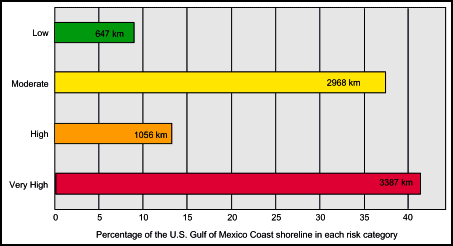 |
Figure 3. Bar graph showing the percentage of shoreline along the U.S. Gulf of Mexico coast in each risk category. The graph also shows the total length of shoreline (in kilometers) in each risk category. The total length of mapped shoreline in this study is 8058 km. |
Figure 3 shows a bar graph of the percentage of shoreline in each risk category. A total of 8058 km of shoreline is evaluated in the study area. Of this total, 42 percent of the mapped shoreline is classified as being at very high risk due to future sea-level. Thirteen percent is classified as high risk, 37 percent as moderate risk, and 8 percent as low risk.
In the calculation of the Coastal Vulnerability Index, certain variables add more weight to the index than others. For example, in a region where most variables score low in the risk ranking (1-3), but one variable scores high (4 or 5), the high variable adds the most weight to the index. This variable is said to dominate the index. In most cases along the U.S. Gulf of Mexico coast, two or three variables dominate the index, while the other, lower-ranking variables have little impact on the index value.
The mapped C.V.I. values show large areas of very high vulnerability, particularly along the Louisiana - Texas coast. The highest-vulnerability areas are typically lower-lying beach and marsh areas; their susceptibility is primarily a function of geomorphology, coastal slope and rate of relative sea-level rise. On the Gulf of Mexico coast, much of the vulnerability is due to geomorphology and tide range; two variables which are ranked as generally high for the entire Gulf of Mexico region. The western Gulf of Mexico is ranked as more vulnerable than the eastern Gulf of Mexico when described in terms of relative sea-level rise. Wave energy is highest along sections of the Texas coast and on the southern tip of the Mississippi delta. The slope variable has the highest risk ranking along the Louisiana coast, the Texas coast north of Corpus Christi and the southwest Florida coast. The erosion rates within the study area range from low risk to very high risk. In contrast to the Pacific and Atlantic coasts (see Thieler and Hammar-Klose, 1999; 2000), the erosion rates in the Gulf of Mexico do not vary consistently on very short spatial scales. Instead, there are reaches of coastline as long as 150 km with the same risk ranking.
|


