U.S. Geological Survey
926A National Center
Reston, VA 20192
Telephone: (703) 648-4317
Fax: (703) 648-6953
e-mail: nstamm@usgs.gov
The U.S. Geological Survey, Geologic Names Committee (GNC) has since the late 1800's documented and maintained a catalog of established and revised geologic units of the U.S., its possessions, and territories. The GNC has published several U.S. geologic names lexicons (Appendix 1) at regular intervals as a means of keeping the geologic profession informed on changes and current status of geologic classifications and nomenclature found in the published literature. During the past hundred years, record keeping of geologic nomenclature has evolved from handwritten index cards into the present-day, web-interfaced relational database called GEOLEX, which is available at http://ngmdb.usgs.gov/Geolex/.
The USGS geologic names lexicon, GEOLEX, a component of the National Geologic Map Database (http://ngmdb.usgs.gov/), is a compilation of geologic names introduced into the literature from 1813 to the present for the U.S., its possessions and territories, and bordering areas of Canada and Mexico. GEOLEX is under construction; it currently contains detailed and general information for 16,005 geologic names compiled from Mac Lachlan, M.E., and others (1996), and comprises approximately 75% of the total number of documented geologic names in the GNC index card catalog. We are now adding the remaining geologic names to the database and updating the database with recently-named and revised geologic units that are recognized by the state geological surveys and the USGS.
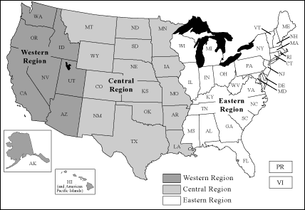
In 1961, the USGS Geologic Names Committee established regional offices in Reston, Virginia (headquarters for the USGS eastern region), Denver, Colorado (central region), and Menlo Park, California (western region) (Fig. 1). Each office reviewed manuscripts to determine compliance with rules of stratigraphic nomenclature, and maintained separate catalogs of geologic nomenclature for specific geographic areas (with the exception of the Reston office, which continued to maintain a National dataset).
With the onset of computer technologies in the 1960's, geologic nomenclature data was entered from the regional Geologic Names Committee card catalogs into a basic spreadsheet-style format and published, as USGS Bulletin 1535 (Swanson and others, 1981). This format was based on recommendations of the American Association of Petroleum Geologists, Committee on Stratigraphic Coding (1967), and is still in use today, although since then many other formats and programming methods have been tried and subsequently discarded by the USGS.
In 1996, the most extensive U.S. geologic names lexicon was released as "Stratigraphic nomenclature databases for the United States, its possessions and territories", USGS Digital Data Series DDS-6 (Mac Lachlan and others, 1996). It consists of 3 regional databases (all called GNULEX), and a concise National database (GEONAMES). The regional GNULEX databases are text-formatted in the style much like the original U.S. geologic names lexicon of Wilmarth (1938). In addition to general information about the geologic name, age, and geographic extent of the unit, these databases include bibliographic references, and synopses of data pertaining to the establishment or revision of the geologic unit compiled from published literature. The National GEONAMES database is spreadsheet-formatted in a style modified from the AAPG-Committee on Stratigraphic Coding (1967) and USGS Bulletin 1535 (Swanson and others, 1981).
During administrative reorganization and staff reductions in 1995, the USGS Geologic Names Committee was restructured and its scope of activities was reduced. The remnants of the Committee were reorganized in the Reston, Virginia offices of USGS. As a result, it was no longer necessary for the GNC to maintain four separate datasets. Also, there was a demand to develop the geologic names lexicon into a format readable by various computer platforms and technologies; further, the new lexicon needed to be easily updated and relatively inexpensive to maintain.
In 1997, we began the task of combining the four databases from USGS Digital Data Series DDS-6 into a single database (GEOLEX) using Microsoft Access. This database is then converted to an Oracle database and connected via scripts to the web-based search engine. GEOLEX data initially was compiled from the GNULEX databases, starting with the eastern region and moving west (Fig. 1). Data from the GEONAMES database was added to GEOLEX last, to fill in data missing from the GNULEX databases. Although its format is obviously more appropriate for database design than the regional GNULEX databases, the data in GEONAMES was not considered inclusive enough for the greater geologic community to effectively research the origin, definition and description, and publication history of geologic units in the U.S.
Today, the USGS Geologic Names Committee continues to review manuscripts, and document and maintain a catalog of geologic nomenclature for the U.S., its possessions, and territories. These data are added to GEOLEX on a regular basis and we are preparing GEOLEX for USGS Director's approval as a "standing database".
The usage, age assignment, geographic area and geologic province allocation, and subunits for geologic units reported on by USGS authors in either USGS or outside formal publications are denoted with an asterisk. Geologic name usage, age, geographic and geologic extent, and subunits not denoted with an asterisk have been published by State Survey and other non-USGS scientists.
|
Figure 1. Map showing generalized areas covered by the USGS Eastern, Central, and Western regional Geologic Names Committee offices from 1961-1995. |
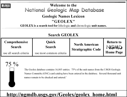
Figure 2. GEOLEX home page. |
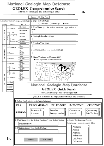
Figure 4. North American Stratigraphic Code.
Upon using the comprehensive or quick search page (Fig. 3) to conduct a search of GEOLEX, the search results page (Fig. 5) is displayed. The results page contains general information about the geologic name. The citation summary page (Fig. 6) is linked from the search results page through the "publication history" field. By selecting the "History" link (Fig. 5), the user can view the bibliographic citations and synopses of information compiled from the publications.
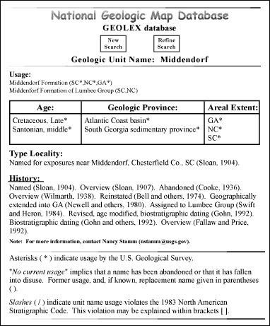
The information displayed on these citation summary pages (Fig. 6) were extracted from the regional GNULEX databases using Perl scripts and cut-and-paste methods to transfer appropriate information to GEOLEX data fields. For the 16,005 geologic names in GEOLEX, there are approximately 30,000 synopses pertaining to the establishment or revision of specific geologic units. These synopses were compiled from approximately 8500 publications.
The "citation summary" page (Fig. 6) includes, for most references cited under "History" in Fig. 5, the following: full bibliographic citation, usage of geologic name in the publication, type of modification (Appendix 2), geologic province, dominant lithology, and a brief synopsis of information pertaining to the geologic unit. The synopses are compiled from the publication, and can include: reason(s) for establishment or modification, type locality or reference section description, study area locality description, geologic setting, lithologic description, thickness of unit, unit correlations, geologic contacts, biostratigraphic and isotopic determinations, geologic age assignment, historical background, and inclusion of correlation charts and maps in the publication.
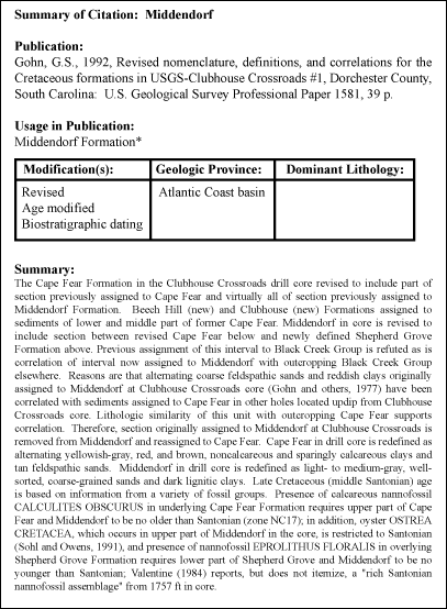
We have updated the bibliographic citations to maintain uniformity. But, the geologic provinces listed on the citation summary page (Fig. 6) have not been updated from Mac Lachlan and others (1996), and thus follow either Meyer (1974) or Meyer and others (1991). Dominant lithologies are listed for publications where the geologic unit is named, and in some cases, where the geologic unit is redescribed, redefined, or mapped.
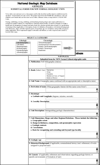
The USGS Geologic Names Committee also will be adding publicly-accessible input forms to allow authors to reserve new geologic names for future publication (Fig. 9). Once the authors have filled in the forms, the names will be checked to ensure that they are not already in use.
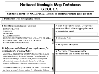
Figure 8. Proposed GEOLEX input form for modifications to existing names. |
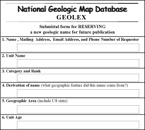
Figure 9. Proposed GEOLEX input form to reserve new geologic names for future publication. |
From time to time throughout its existence, the USGS Geologic Names Committee has solicited the advice and assistance from State Survey geologists on the preferred usage of geologic nomenclature in their state. When we assembled the data from the regional databases into one database and analyzed it, we concluded that we are not adequately depicting current State Survey geologic nomenclature. It has, therefore, been resolved that each State Survey has the final authority on stratigraphic nomenclature within their state, provided that it complies with the North American Stratigraphic Code; the USGS Geologic Names Committee plans to work with State Survey geologists to resolve any discrepancies.
Hansen, W.R., ed., 1991, Suggestions to authors of the reports of the United States Geological Survey; Seventh edition: U.S. Government Printing Office, Washington, DC, 289 p.
Haq, B.U., and van Eysinga, F.W.B., 1987, Geological time table (revised): Elsevier Science Publishing Co., New York, NY, 1 sheet.
Harland, W.B., and others, 1989, A geologic time scale (revised): Cambridge University Press, Cambridge, Great Britain, 263 p.
Mac Lachlan, M.E., and others, compilers, 1996, Stratigraphic nomenclature databases for the United States, its possessions, and territories: U.S. Geological Survey Digital Data Series DDS-6, Release 3, 1 CD ROM.
Meyer, R.F., ed., 1974, AAPG-CSD geological provinces Code map (revised): American Association of Petroleum Geologists, Tulsa, OK, 1 sheet, scale 1:500,000.
Meyer, R.F., Wallace, L. G., and Wagner, F. J., Jr., 1991, AAPG-CSD geological provinces code map: American Association of Petroleum Geologists Bulletin, v. 75, no. 10, p. 1644-1651.
North American Commission on Stratigraphic Nomenclature, 1983, North American stratigraphic code: American Association of Petroleum Geologists Bulletin, v. 67, no. 5, p. 841-875.
Reed, J.C., 1987, Precambrian geology of the U.S.A.: Episodes, v. 10, no. 4, p. 243-247.
Swanson, R.W., Hubert, M.L., Luttrell, G.W., and Jussen, V.M., 1981, Geologic names of the United States through 1975: U.S. Geological Survey Bulletin 1535, 643 p.
Wilmarth, M.G., 1938, Lexicon of geologic names of the United States (including Alaska): U. S. Geological Survey Bulletin 896, pt. 1, A-L, p. 1-1244; pt. 2, M-Z, p. 1245-2396.
1. Weeks, F.B., 1902, North American geologic formation names; bibliography, synonymy, and distribution: U.S. Geological Survey Bulletin 191, 448 p.
2. Wilmarth, M.G., 1938, Lexicon of geologic names of the United States (including Alaska): U. S. Geological Survey Bulletin 896, pt. 1, A-L, p. 1-1244; pt. 2, M-Z, p. 1245-2396.
3. Wilson, Druid, Sando, W.J., Kopf, R.W., and others, 1957, Geologic names of North America introduced in 1936-1955: U.S. Geological Survey Bulletin 1056-A, p. 1-405.
4. Wilson, Druid, Keroher, G.C., and Hansen, B.E., 1959, Index to the geologic names of North America: U.S. Geological Survey Bulletin 1056-B, p. 407-622.
5. Keroher, G.C., and others, 1966, Lexicon of geologic names of the United States for 1936-1960: U.S. Geological Survey Bulletin 1200, pt. 1, A-F, p. 1-1448; pt. 2, G-O, p. 1449-2886; pt. 3, P-Z, p. 2887-4341.
6. Keroher, G.C., 1970, Lexicon of geologic names of the United States for 1961-1967: U.S. Geological Survey Bulletin 1350, 848 p.
7. Luttrell, G.W., Hubert, M.L., Wright, W.B., Jussen, V.M., and Swanson, R.W., 1981, Lexicon of geologic names of the United States for 1968-1975: U.S. Geological Survey Bulletin 1520, 342 p.
8. Swanson, R.W., Hubert, M.L., Luttrell, G.W., and Jussen, V.M., 1981, Geologic names of the United States through 1975: U.S. Geological Survey Bulletin 1535, 643 p.
9. Luttrell, G.W., Hubert, M.L., and Jussen, V.M., 1986, Lexicon of new formal geologic names of the United States 1976-1980: U.S. Geological Survey Bulletin 1564, 191 p.
10. Luttrell, G.W., Hubert, M.L., and Murdock, C.R., 1991, Lexicon of new formal geologic names of the United States 1981-1985: U.S. Geological Survey Bulletin 1565, 376 p.
11. Mac Lachlan, M.E., and others, 1996, Stratigraphic nomenclature databases for the United States, its possessions, and territories: U.S. Geological Survey Digital Data Series DDS-6, Release 3, 1 CD ROM.
1. ABANDONED. Author(s) provides sufficient justification to abandon name and make recommendations for replacement name(s) in accordance with the NACSN 1983 Code. Please include reasons for abandonment and replacement names. Not used for restriction of areal extent. (ALSO SEE "NOT USED" AND "AREAL LIMITS")
2. ADOPTED (USGS). A USGS author may adopt a unit name for USGS usage by citation [i.e., explicit statement of intent to name a new unit or adopt the previously published unit usage of another (non-USGS) author] in a formal publication. It is the author's responsibility to determine whether the unit, as previously defined (by a non-USGS author), is properly defined according to NACSN 1983 Code; if it has not been sufficiently defined, additional information must be included to conform with the NACSN and USGS standards.
3. AGE MODIFIED. Age of unit has been changed or refined either regionally or locally. Please include evidence for age change. (ALSO SEE "BIOSTRATIGRAPHIC DATING" AND "ISOTOPIC DATING")
4. AREAL LIMITS. Geographic extension or restriction of unit on surface and/or in subsurface. Also used when report discusses known areal extent of unit. Please note scale and includsion of geologic or isopach maps in report.
5. BIOSTRATIGRAPHIC DATING. Age determination of unit based on recognition of index fossils or biozonal assignment. Does not include mere mention of fossils. Please include fossil types. (ALSO SEE "AGE MODIFIED")
6. ISOTOPIC DATING. Numerical age of unit determined from isotopic ratios, fission tracks, and other age-related phenomena. Please include dating technique and error values. (ALSO SEE "AGE MODIFIED")
7. NOT USED. Unit name has been rejected (but not formally abandoned) by author, in preference to another name. Please include reason for non-use, if stated in report. (ALSO SEE "ABANDONED")
8. OVERVIEW. Report includes detailed local or regional information (i.e., measured sections, source, environment of deposition, thickness of unit). Also used to indicate continued use of an old, but seldom used name. Please note inclusion of geologic, isopach, or areal extent maps; cross sections; correlation charts or history-of-use charts; or other pertinent figures in report.
9. PALEOMAGNETICS. Determinations based on remnant-magnetic properties; most commonly polarity (normal or reversed). Please include dipole-field-pole position, non-dipole component, and field intensity if possible.
10. PRINCIPAL REFERENCE (SECTION, LOCALITY, OR AREA). Principal reference is designated in report. Generally applies to units for which no type locality has been previously designated. Please include measured section(s); description of lithology, contacts, and thickness. Also, note pertinent figures in report. (ALSO SEE "REFERENCE")
11. REFERENCE (SECTION, LOCALITY, OR AREA). Addendum to the type or principal reference section. Provides further thickness and lithological information. Please include description of rocks at reference section(s). Also, note pertinent figures in report. (ALSO SEE "PRINCIPAL REFERENCE").
12. REDESCRIBED OR REDEFINED. Unit composition is changed due to geochemical analyses, detailed mapping, etc. Descriptive lithic or rank term changed because of change in dominant lithology. (ALSO SEE "REVISED").
13. REVISED. Applied when stratigraphic rank, contacts (new name applied to rocks below or above), affiliations (divided into units of lesser rank; assigned to a unit of higher rank), or spelling of name has been changed. (ALSO SEE "REDESCRIBED OR REDEFINED")
14. REINSTATED. Reserved for reinstatement of abandoned names in accordance with the NACSN 1983 Code. Original definition may be accepted or modified in report. Please include reasons for reinstatement.
*Adapted from Mac Lachlan, M.E., and others, compilers, 1996, Stratigraphic nomenclature databases for the United States, its possessions, and territories: U.S. Geological Survey Digital Data Series, DDS-6, Release 3, and North American Commission on Stratigraphic Nomenclature, 1983, North American stratigraphic code: American Association of Petroleum Geologists Bulletin, v. 67, no. 5, p. 841-875.