|
Introduction
The Los Angeles, California Margin was mapped using multibeam echosounders during three separate surveys (Figure 1). In 1996, the USGS surveyed the shelf and slope in Santa Monica Bay from Pt. Dume to south of the Palos Verdes Peninsula. The mapping was accomplished using a Kongsberg Simrad EM1000 multibeam sonar system that provided high-quality bathymetry and quantitative backscatter. In 1998, the USGS continued the mapping to the south and surveyed the outer shelf, slope, and proximal basin off Long Beach and Newport using a Kongsberg Simrad EM300 multibeam sonar system. In 1999, the Los Angeles Margin mapping was completed with the surveying of the inner Long Beach shelf from the Palos Verdes Peninsula, south to Newport. This survey used a dual Kongsberg Simrad EM3000D multibeam sonar system.
These three surveys were conducted to support USGS projects studying marine pollution and geohazards along the Los Angeles Margin.
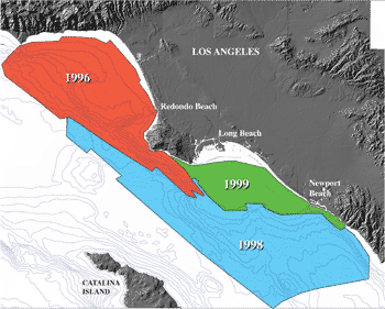
Figure 1. Location of the Los Angeles Margin multibeam sonar surveys. The red polygon shows the area mapped in 1996 using a Kongsberg Simrad EM1000, the blue polygon shows the area mapped in 1998 using a Kongsberg Simrad EM300, and the green area shows the area mapped in 1999 using a dual Kongsberg Simrad EM3000 multibeam system.
This Open-File Report provides the multibeam bathymetry and acoustic backscatter data in two different formats, ASCII XYZ and ArcInfo GRID that can be used in a number of GIS applications. This report also provides FGDC compliant metadata for the bathymetry and backscatter data along with images, perspective views, a fly-by movie, and a freeware GIS generated from the multibeam data.
For more information about the Los Angeles, California Margin multibeam surveys, visit our Pacific Seafloor Mapping website.
TOP OF PAGE
Metadata
The multibeam bathymetry and backscatter data are published in two formats; ASCII XYZ and ArcInfo GRID. FGDC metadata is provided for each format and is available in three different forms, text, HTML, and FAQ (Frequently Anticipated Questions).
NOTE: The bathymetry data from the three surveys have been merged together into one complete dataset. The bathymetry metadata is provided in one file (3 forms). However, the backscatter data for each survey are published as separate datasets. The different multibeam sonar systems operate at different frequencies resulting in different backscatter intensities, depth of penetration, etc (see backscatter imagery). While pixel values are relative to other values within a survey, pixel values are not relative between surveys. Backscatter metadata is provided for each survey separately.
|
![[Perspective view of Los Angeles margin]](images/homepersp.gif)

![[Reports]](http://walrus.wr.usgs.gov/images/nav_rprt.gif)

![[Home]](http://walrus.wr.usgs.gov/images/nav_home.gif)
![[Search]](http://walrus.wr.usgs.gov/images/nav_srch.gif)
