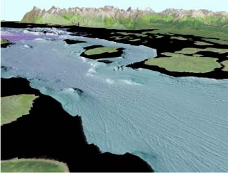
Perspective view of Sitakaday narrows in Glacier Bay, Alaska,
showing prominent iceberg gouges in bay floor. The distance across
the bottom of the image is about 2.0 km (1.2 miles) with a vertical
exaggeration of 2x.
Introduction
Glacier Bay is a diverse fjord ecosystem with multiple tidewater
glaciers and complex biological, geological, and oceanographic patterns
that vary greatly along its length. The bay was completely glaciated
prior to the 1700's, and subsequently experienced the fastest glacial
retreat recorded in historical times (Fig. 1). As a result, some
of the highest rates of glacial sedimentation and uplift are observed
here.
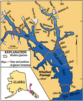
Figure 1. Location map of Glacier Bay National Park showing terminus
positions and dates of retreat of the Little Ice Age glacier that
completely filled the bay somewhat more than 200 yrs ago. The 1794
terminous line near the mouth of the bay is where Capt. George Vancouver
and crew observed the massive glacier face during their hunt for
the Northwest Passage. The 1879 glacier terminous position was mapped
by John Muir during his first of several visits to Glacier Bay.
Trapezoid outlines the Whidbey Passage study area. Modified from
Seramur et al. (1996).
Glacier Bay is the deepest silled fjord in Alaska, with depths
of over 450 meters. The variety of physical processes (for example
icebergs gouging, see Fig. 2) and depths creates many diverse habitats
within a relatively small area. Mapping benthic (seafloor) habitats
is thus crucial to understanding and managing Glacier Bay's complex
marine ecosystem and the marine species therein. High-resolution
multibeam mapping of the bay, funded jointly by USGS and the National
Park System, provides an unprecedented new baseline for resource
and habitat assessment. Full integration of the new data set will
require additional ground-truthing data (sampling) and analysis.
The USGS goal is to develop integrated geological and oceanographic
habitat models for the marine benthos in Glacier Bay, as a step
toward determining the habitat relationships of critical species
and resources within the Park.
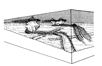 Figure 2. Single icebergs that come in contact with the seafloor
will produce grooves in unconsolidated sediments ranging from mud
to coarse gravel. These iceberg gouges may change shape and direction
in response to changes intidal currents. Illustration from Reimnitz
et al. (1973).
This Open-File Report publishes the multibeam bathymetry along
with images.
References
Seramur, Keith C., Powell, R.D., Carlson, P.R., 1996. Evaluation
of conditions along the grounding line of temperate marine glaciers:
an example from Muir Inlet, Glacier Bay, Alaska. Marine Geology
140, 307-327.
Reimnitz, E., P.W. Barnes, and T. R. Alpha, 1973, Bottom features
and processes related to drifting ice on the Arctic Shelf, Alaska:
USGS Miscellaneous Field Studies Map MF-532.
To order a glossy paper poster version of this website contact:
USGS
Information Services
Box 25286
Denver, CO 80225
Telephone (888) ASK-USGS |