 Introduction Introduction
During the mid-to late-1800's, large quantities of tailings from hydraulic gold mining in the Sierra Nevada were deposited in San Francisco Bay (Gilbert, 1917; Jaffe et al., 1998; Capiella et al., 1999). This rapid deposition also choked river systems and deposited mercury-contaminated sediments in the rivers and Bay. Hydraulic mining was stopped in 1884 by a California Supreme Court decision. Deposition in the Bay slowed in the late 1800's and early 1900's as a result of this decrease in sediment supply (Jaffe et al., 1998; Capiella et al., 1999). During the mid-1900's, sediment supply was further reduced by water works projects (dams, diversions, etc.), creating an erosional system in the study area by the late 1900's. The re-working of these sediments poses environmental and biological concerns regarding mercury in the bay. The location of these deposits is important for understanding the health of the bay waters.
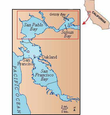
In March 2000, the U.S. Geological Survey collected sediment cores in the study area to determine the location of mercury-contaminated hydraulic mining debris. The study area (Figure 1) comprises 400 km2 and consists of San Pablo Bay and Suisun Bay, both of which are part of the San Francisco Bay estuary. Grizzly Bay, a subembayment of Suisun Bay, is also part of the study area. For the purpose of this report the term Suisun Bay will be used collectively for both areas. The present channel system in Suisun Bay is composed of three channels that flow through the bay. The primary channel runs in the southern section of Suisun Bay. A smaller channel flows between Roe Island and Ryer Island. The deepest channel flows through Suisun Cutoff, north of Ryer Island, and past Grizzly Bay. All three channels join at Carquinez Strait where they continue through the southern section of San Pablo Bay, and into San Francisco Bay. The average depths in San Pablo and Suisun Bays at mean sea level are 3.7 m and 5.8 m, respectively (Smith et al., 2002).
|
Part or all of this report is presented in Portable Document Format (PDF). For best results viewing and printing PDF documents, it is recommended that you download the documents to your computer and open them with Adobe Reader. PDF documents opened from your browser may not display or print as intended. Download the latest version of Adobe Reader, free of charge.
|

