Digital Mapping Techniques '03
— Workshop Proceedings
U.S. Geological Survey Open-File
Report 03–471
The National Geologic Map Database Image Library—General Concepts
1U.S. Geological Survey, 926-A National Center,Reston, VA 20192
Telephone (703) 648-6907; fax (703) 648-6977; e-mail drsoller@usgs.gov
2Ohio Geological Survey
Telephone (614) 265-6988; fax (614) 268-3669; e-mail thomas.berg@dnr.state.oh.us
INTRODUCTION
The Geologic Mapping Act of 1992 and its reauthorizations mandate creation of a National Geologic Map Database (NGMDB), to serve as a “national archive” of geoscience maps. The U.S. Geological Survey (USGS) and the state geological surveys (through the Association of American State Geologists, or AASG) are collaborating on the design and the many components of the NGMDB project.
Consistent with the Act’s intention, the project’s overall objective is to provide the public with information and access to products that may be needed for purposes ranging from decisionmaking to education and personal interest. The mandate is at least partially fulfilled through the NGMDB’s Map Catalog (Soller and Berg, this volume; Soller and Berg, 1999). The Map Catalog (http://ngmsvr.wr.usgs.gov/ngmdb/ngm_catalog.ora.html) lists bibliographic information about each geologic map and other geoscience products published for the United States and its territories and possessions. The bibliographic information and the contact information provided by the Map Catalog facilitate the borrowing, purchasing, and, in some cases, the downloading of map information.
We also are designing a standardized database of vector-based geologic map information that users can display and query via the Web, and then download selected data. The database will be a computer system distributed among all participating geological surveys in the United States. This technically difficult task has been proceeding slowly but steadily, as noted in various progress reports (Soller and others, 2001; Soller and Berg, 2002). The AASG and USGS are working together to build the foundation for the online map database, by developing the necessary technology, science concepts and data model, and by building digital geologic map coverage for the nation.
The NGMDB’s Map Catalog and vector-based map database can be considered as endpoints on a spectrum of information content, ease-of-use, and system complexity. The Map Catalog is relatively straightforward to use, and since 1997 it has provided bibliographic information about each geoscience map product. In contrast, the online map database is in the design phase; when publicly available, it will provide full access to detailed geologic map information. However, many users may not be sufficiently familiar with geoscience concepts to comfortably use its Web query interface. Further, many users will be unfamiliar with the format of GIS data to be offered for download; from user remarks regarding downloadable data now available from agency Web sites, we know this is frustrating.
We have the opportunity, somewhere in the middle of this spectrum, to provide users with geologic map information in a raster image format, thereby allowing them Web access to the familiar, traditional geologic map format (fig. 1). This is an important point, because the Web has increased the public’s expectation for quick and reliable access to information. Although the Map Catalog informs the user that a map exists, and where it can be obtained, this is not sufficient for all purposes. Through discussions with users, and from comments received via our Web feedback form, it has become clear that many people are interested in viewing and/or obtaining maps online. Interpretation of the phrase “providing maps online” varies widely—to some people, it implies access to fully attributed, vector-based map databases, whereas to others, it implies access to map images. For example, a county planner contacted us because he could not view with common desktop office software the USGS topographic map data that he had downloaded. That file contained vector map data in the Spatial Data Transfer Standard (SDTS) format, which was not appropriate for the planner’s needs—he simply wanted to view and browse an electronic facsimile of a paper map. This example highlights our mandate—to address the needs of all users, of various backgrounds and interests.
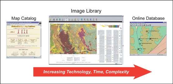 |
Figure 1. In technological complexity, ease-of-use, and related issues, the Image Library occupies a middle ground between the Map Catalog and the online map database. |
We are not yet ready to deploy a vector-based map database, but we can more quickly and efficiently develop the capability to let users view a digital image of a map online, and to read the detailed descriptions that accompany it. Therefore, the NGMDB has begun a new project initiative to build a library of images of general-purpose bedrock and surficial geologic maps. Map image libraries are not a new concept; they have successfully been developed by various agencies including the Library of Congress (Cahill and others, 2002) and state geological surveys (for example, Davidson and others, 2002). In this paper and in another paper in this volume (by Wardwell and others), we discuss the relation between the Image Library and the NGMDB Map Catalog, the capability for the Library to be a distributed database, and its technological foundation.
USER INTERFACE
The NGMDB’s Image Library (see link at http://ngmdb.usgs.gov/) provides public access to images of selected general-purpose bedrock and surficial geologic maps, through an intuitive Web search interface. The search mechanism is geographically based, allowing for selection of geologic maps by location. From a base map of the U.S. or a state, the user can see where the NGMDB has map images available. When the user clicks on any of the geologic map thumbnail images displayed on the base map, the database is searched for all available scanned maps within a specified radius of the selected point (for example, within 25 miles). Results are returned to the user as an information table that shows a thumbnail image of each map within the search radius, and the map title, author, publisher, and scale (fig. 2).
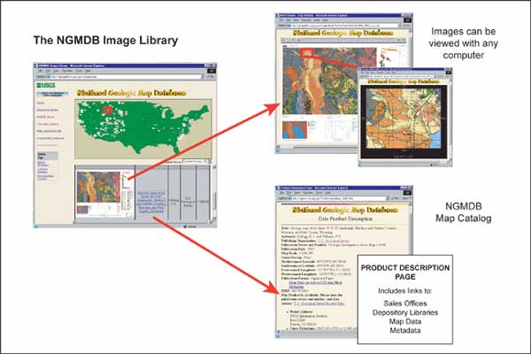 |
Figure 2. The Image Library site. After selecting from the geographic search, an information table that shows all available map images is presented to the user. This table provides links to the JPEG and the ExpressView image-browsing interfaces (in this figure, both are shown — the more detailed map view appears in the JPEG interface). The table also links to the NGMDB Map Catalog product description page, map sales offices, a list of depository libraries, and downloadable map data and its metadata. |
If the thumbnail image is selected by a mouse click, a JPEG image is shown in a new window. Zoom and pan functions allow the user to read details on the map with excellent resolution, because each time the user zooms or pans, the high-resolution (300dpi) source image residing on the server is accessed and a 72dpi image, properly sized for the display window, is returned to the user (fig. 3). If we have permission to offer the map image for download at no cost to the user, a link in the new window offers this option (for example, all USGS maps are available for free download, but some agencies may need to charge a fee). The downloadable images are in the MrSID format, roughly 15-25MB in size; the 300dpi TIFF files from which the MrSID files were created are roughly 400-600MB in size, and are available to users upon special request.
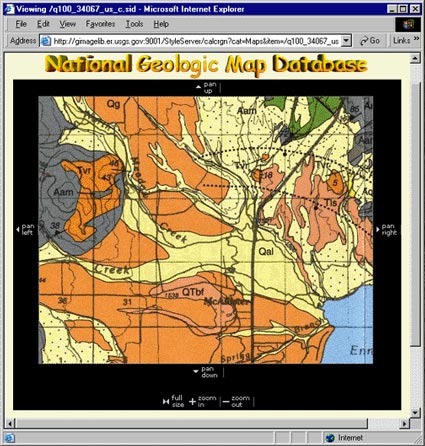 |
Figure 3. Example image from JPEG image-browsing interface, showing good-quality resolution. Image is from Kellogg and Williams (2000). |
If the user has a computer with the Windows operating system (Win98 or newer), the Lizardtech ExpressView browser plugin enables viewing of the MrSID images, through the Image Library Web interface or by downloading the file and opening it locally in the Web browser. These options are provided by a link below the map thumbnail image. This browser plugin offers somewhat more efficient zoom and pan functions than the JPEG display, and the ability to zoom to (and past) the full resolution of the image.
In the information table, the map title is linked to its Product Description Page in the Map Catalog, which provides the user with bibliographic information and links to purchase the map, download it, or borrow it from a library. In the near future, we anticipate placing the thumbnail image of the map on the Product Description Page, and allowing links from the Map Catalog to the JPEG image in the Image Library.
STATUS
The NGMDB Image Library is being populated with MrSID-compressed images derived from 300dpi, 24-bit color scans that are stored off-line as TIFF files. We began the prototype Library by scanning 1:100,000-scale bedrock and surficial geologic maps published by the USGS. We now are scanning USGS maps published at 1:24,000-scale, and will include maps at other scales. At present, we are limiting our efforts to maps in paper format. However, we intend to serve (through a mechanism not yet determined) the images of maps that have been published only as digital datasets.
Because we have limited staff resources for this task, we have developed a database-management system (DBMS) to increase the efficiency with which both we and our cooperators can either load images into the Library, or link images to it. The DBMS is based on open-source architecture, and is described in another paper in this volume (Wardwell and others). In part, this system is intended to promote state geological survey participation, which is essential for the Image Library to become a comprehensive, useful resource. Contribution of maps to the Image Library is being designed as a simple process that involves Web forms and ftp data transfers. Agencies that would like to contribute to the Library should address two issues:
If an agency wishes to charge a fee for downloading, or chooses not to allow downloading, this is quite reasonable and can be readily handled by the Image Library—as noted above, all maps in the Image Library are recorded in the Map Catalog, which provides direct links to agency map sales offices, so users can be advised of agency policies and fees.
If a cooperating agency chooses to manage the map images on their server, the Image Library DBMS would merely need to receive the URL and a thumbnail image for each map. To promote consistency in presentation of map images, we would prefer links to MrSID images. However, if the agency is charging a fee for access to the map, then they might choose to provide a URL only to a JPEG image of medium or low resolution.
If the agency prefers the USGS Image Library server to manage their map images, we would need only the TIFF and/or the MrSID images. If the agency wishes to participate but cannot create the scanned images, the USGS would scan selected agency maps and process them for the Image Library. Figure 4 shows these participation options.
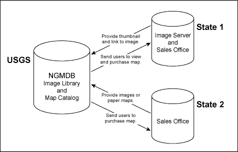 |
Figure 4. Participation by the USGS and state geological surveys is important in order to build a useful resource for public and private sector end users. State geological surveys choose how they wish to be involved. |
SUMMARY
The USGS/AASG National Geologic Map Database (NGMDB) project has begun providing a Web-accessible Image Library of scanned geologic maps. This involves generating and processing scanned, high-resolution compressed imagery of selected general-purpose bedrock and surficial geologic maps that are recorded in the NGMDB Map Catalog. Scanned images of the selected geologic maps are formatted as compressed MrSID files, which can be viewed through a Web browser with no visible loss in clarity. The NGMDB Image Library is based on open-source architecture, and includes a database management system intended to promote participation by numerous agencies, principally the state geological surveys. The user interface is now available in prototype form, and we will continue to upgrade its map query options, user forms, and help pages. We hope this new NGMDB initiative further strengthens the cooperative relationship between the AASG and the USGS.
REFERENCES
Cahill, C.R., Roberts, G.E., and Schug-O’Neill, Diane, 2002, Scanning and delivery of historic maps over the Web: The Library of Congress experience, in D.R. Soller, ed., Digital Mapping Techniques ’02—Workshop Proceedings: U.S. Geological Survey Open-file Report 02-370, p. 99–104, http://pubs.usgs.gov/of/2002/of02-370/cahill.html.
Davidson, Gail, Staft, Lauren, and Daley, E.E., 2002, The Alaska DGGS scanning project: Conception, execution, and reality, in D.R. Soller, ed., Digital Mapping Techniques ’02—Workshop Proceedings: U.S. Geological Survey Open-file Report 02-370, p. 105–110, http://pubs.usgs.gov/of/2002/of02-370/davidson.html.
Kellogg, K.S., and Williams, V.S., 2000, Geologic map of the Ennis 30’ X 60’ quadrangle, Madison and Gallatin Counties, Montana, and Park County, Wyoming: U.S. Geological Survey Geologic Investigations Series Map I-2690, scale 1:100,000, http://pubs.usgs.gov/imap/i-2690/.
Soller, D.R., and Berg, T.M., 2002, The National Geologic Map Database: A progress report, in D.R. Soller, ed., Digital Mapping Techniques ’02—Workshop Proceedings: U.S. Geological Survey Open-file Report 02-370, p. 75–83, http://pubs.usgs.gov/of/2002/of02-370/soller2.html.
Soller, D.R., and Berg, T.M., 1999, Building the National Geologic Map Database: Progress and challenges, in Derksen, C.R.M., and Manson, C.J., eds., 1999, Accreting the continent’s collections: Geoscience Information Society Proceedings, v. 29, p. 47–55, http://ncgmp.usgs.gov/ngmdbproject/reports/gisproc98.html.
Soller, D.R., Wahl, Ron, Weisenfluh, Jerry, Brodaric, Boyan, Hastings, Jordan, Laudati, Robert, Fredericks, Roger, 2001, Progress report on the National Geologic Map Database, Phase 3: An online database of map information, in D.R. Soller, ed., Digital Mapping Techniques ’01—Workshop Proceedings: U.S. Geological Survey Open-file Report 01-223, p. 71–78, http://pubs.usgs.gov/of/2001/of01-223/soller2.html.