Introduction to the
Mojave National Preserve
General Mojave
Geologic History
Changing Climates
& Ancient Lakes
Weathering and Erosion in Desert Environments
Mountains form because, over long periods of time, uplift proceeds faster than erosion can keep pace. Through time, erosion progressively carves canyons into mountainous areas. Mountain stream channels are self-perpetuating; as water gathers into rills and channels, the greater the flow, the greater the erosive force. Likewise, streams with steep drainage profiles are capable of moving more material.
Without abundant water in the arid environment, the chemical breakdown of rocks proceeds extremely slowly relative to equivalent rocks in humid climates. However, it is somewhat paradoxical that the mechanical breakdown of rock proceeds relatively quickly in the arid climate. In wet regions, the ground remains partially or fully saturated. Plants typically cover the landscape and bind the soil, and hence, prevent erosion. In dry climates, soil forms very slowly, and much of the bedrock remains exposed to erosion. Physical forces in the desert that break down rocks include the daily heating and cooling of rocks on the surface, expansion of plant root in cracks, the freezing and melting of ice in cracks, and exposure to wind and precipitation (particularly during storms). When rainfall occurs, particularly long-slow drenching rain, the mountain slopes become saturated. The added weight induces rock falls, landslides, and other forms of mass movement of material down slope. Even though rain falls infrequently in the desert, when it does rain large quantities of sediment move down slope and into canyons entrained in flash-flood waters or as debris flows. A debris flow is a moving mass of rock fragments, mud, soil, and enough water to keep the mass fluid. They typically travel at great speeds down steep canyons, but may move slowly across a gentle surface of an alluvial fan. They can flow for great distances until the water they contain dissipates or separates from the alluvial material.
The churning action of flood waters or sediment-choked debris flows pulverize rocks into fragments (gravel, sand, silt, and clay). As rocks break into smaller and smaller fragments, the surface area of the resulting sediment volume increases. This increase in surface area accelerates the chemical changes that convert feldspar and other minerals in granite into clays. Soluble components in the rock dissolve and are carried away. With increasing distance away from mountain sediment source areas, the average size of rock fragments steadily diminishes and particles become increasingly round in shape.
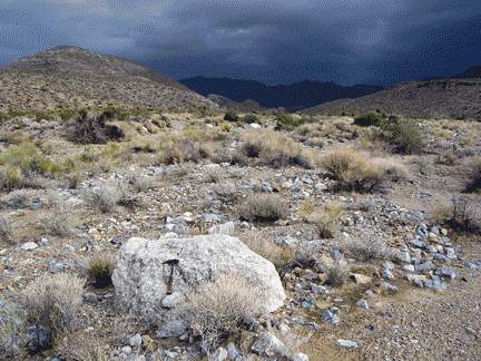 |
| A large granitic boulder and gravel deposits in the middle of the flood plain of a wash draining from the range hints at the power and intensity of flash floods or debris flows that episodically transport material from the Providence Mountains onto the alluvial fan. Hills that define the mountain front consist of older Pleistocene alluvial fan deposits that accumulated when stream base level was higher. Winter storm clouds hang over the Providence Mountains in the distance. |
The character of the bedrock in mountain source areas plays a significant role in determining the character of sediments and soils in downstream areas (on pediment surfaces, alluvial fans, stream channels, and playa marginal areas), and the character of vegetation and fauna they support. Dominant rock types in the Mojave region include granite and ancient crystalline rocks, Paleozoic sedimentary rocks (mostly carbonates, limestone and dolostone), volcanic materials (mostly basalt), and reworked alluvial materials. Weathering and erosion of these types of bedrock produce the diverse and often unique landscapes in the Mojave region.

