THE OLYMPIC NATIONAL PARK
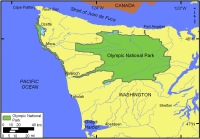 |
| Figure 1. Location of Olympic National Park in Northwest Washington. Click on figure for larger image. |
The rugged landscape of Olympic National Park (Figure 1) is a result of the subduction of the Juan de Fuca oceanic plate below the North American plate beginning about 35 million years ago. The mountains within Olympic National Park are geologically very young, and as a consequence the surrounding landscape is young and varies widely in morphology. Large ice sheets during Pleistocene glaciations (2 million - 13,000 years ago) further modified the geomorphology of the park by carving deep U-shaped valleys dipping toward a sediment-starved collision coast. The park shoreline is over 100 km (~ 65 miles) of primarily rocky and cliffed coast with intermittent sand or gravel pocket beaches. Approximately 95% of the park is designated as wilderness making it a very beautiful and pristine shore. Seaward of the Olympic shoreline lies the Olympic Coast National Marine Sanctuary administered by the National Oceanic and Atmospheric Administration.
In addition to the coastal impacts associated with predicted sea-level rise, Olympic is also susceptible to tsunamis generated both locally and distant. The presence of the subduction zone a few hundred miles offshore poses a constant threat to earthquake-generated tsunamis. The Northwest Washington coast is also periodically impacted with increased storminess, shoreline erosion, large wind driven waves, and elevated sea levels associated with El Niño events (Komar, 1997).