


 |
|
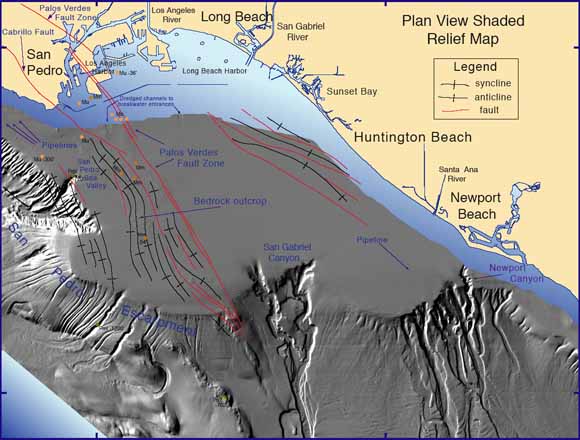
These maps show a) multibeam shaded relief and bathymetry of San Pedro Shelf Region, b) tracklines along which the data collected were used for interpretations, c) locations of faults and folds, especially Palos Verdes Fault Zone, based on that interpretation, d) isopach map of unconsolidated sediments, e) sediment thickness in paleo-valley and associated drainage basins. In addition to the maps, many examples are shown and lists provided of geophysical (seismic-reflection) data used for interpretations. The set consists of seven color sheets of maps and seismic-reflection profiles. Lat 33°28'N to 33°47'N, long 117°50'W to 118°20'W. Approximate scales as follows: Sheet 1 approx. 1:66,000; sheets 2, 3, 4&7 approx. 1:87,000; sheet 5 approx. 1:174,000; sheet 6 approx. 1:43,000. Sizes as follows: Sheets 1&3 are 48 by 36 inches; sheets 2, 4&5 are 36 by 48 inches; sheets 6&7 are 36 by 24 inches. We have also provided the same set of maps at half-size; these are more apt to be something a user could print on a large printer or medium-sized plotter. |
Download Sheet 2: Multibeam shaded relief and bathymetric maps of the San Pedro Shelf region (11.7 MB)
Download Sheet 3: Isopach map of unconsolidated sediment and seismic profile examples (13.1 MB)
Download Sheet 4: Seismic-reflection profiles across the Palos Verdes Fault Zone along the outer edge of the San Pedro Shelf (39.1 MB)
Download Sheet 5: Palos Verdes Fault Zone geologic map, cross-section, and seismic profiles (30.1 MB)
Download Sheet 6: Isopach map showing the approximate thickness of uppermost Holocene(?) sediment layer (1.2 MB)
Download Sheet 7: San Gabriel Canyon paleo-valley and associated drainage basins (1 MB)
Download Sheet 2, half-sized: Multibeam shaded relief and bathymetric maps of the San Pedro Shelf region (7 MB)
Download Sheet 3, half-sized: Isopach map of unconsolidated sediment and seismic profile examples (7.7 MB)
Download Sheet 4, half-sized: Seismic-reflection profiles across the Palos Verdes Fault Zone along the outer edge of the San Pedro Shelf (22.6 MB)
Download Sheet 5, half-sized: Palos Verdes Fault Zone geologic map, cross-section, and seismic profiles (31.8 MB)
Download Sheet 6, half-sized: Isopach map showing the approximate thickness of uppermost Holocene(?) sediment layer (1.3 MB)
Download Sheet 7, half-sized: San Gabriel Canyon paleo-valley and associated drainage basins (1 MB)
| Help
| PDF help
| Publications main page | Open-File
Reports for 2004 | This report
is also available via print on demand from: USGS Information
Services, Box 25286,
Federal Center, Denver, CO 80225
telephone: 303-202-4210; e-mail: infoservices@usgs.gov
| Department of the Interior
| U.S. Geological Survey |
URL of this page: http://pubs.usgs.gov/of/2004/1049/
Maintained by: Michael Diggles
Date created: May 28, 2004
Date last modified: May 4, 2006 (mfd)