The Gateway National Recreation Area
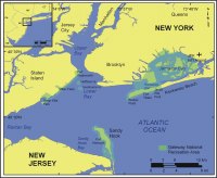 |
| Figure 1. Location of Gateway National Recreation Area in New York and New Jersey. Click on figure for larger image. |
Gateway National Recreation Area (GATE) is broken into 3 units, Staten Island, Jamaica Bay, and Sandy Hook, along the metropolitan shoreline of New York and New Jersey (Figure 1). This National Recreation Area consists of over 45 km (28 miles) of open to near open-ocean shoreline at the entrance of New York Harbor, as well as 40 km² (10,000 acre) of saltmarsh estuary within Jamaica Bay. This report will focus on the three park areas considered open-ocean: Sandy Hook and Staten Island Units, and the Breezy Point District of Jamaica Bay Unit. The remainder of the Jamaica Bay Unit consists of saltmarsh and tidal creeks and is not well suited for this project.
The Breezy Point District
The Breezy Point District lies within the Jamaica Bay Unit on the western end of Rockaway Peninsula (Figure 1). Together Breezy Point and Sandy Hook produce the 'gates' to New York Harbor, thus becoming know as the 'Gateway to Freedom' to many immigrants arriving in the New World. Rockaway Peninsula and the other barriers of Long Island's South Shore began forming seaward of their present location about 8,000 years ago as glacial-fluvial sediments were reworked by waves and currents. Historically, Rockaway built westward in response to the dominant longshore transport current until the jetty at Breezy Point, installed in the 1930s, prevented further progradation to the west. Fort Tilden and Jacob Riis Park are two cultural and recreational attractions within the Breezy Point District.
Staten Island Unit
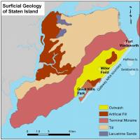 |
| Figure 2. Surficial geology map for Staten Island (Soren, 1988). Click on figure for larger image. |
The Staten Island Unit lies on the southeast side of Staten Island and faces into Lower New York Bay (Figure 1). A terminal moraine of the Laurentide icesheet passes across Staten Island, and controls the coastal geology for this area (Figure 2). Fronting the moraine are outwash sands and gravels, which comprise the majority of the National Recreation Area (NRA) on Staten Island. However, Great Kills Park lies on top of historic artificial fill, and a portion of Fort Wadsworth is built upon the terminal moraine. Two islands that lie offshore of Staten Island, Hoffman and Swinburne Islands are also part of the NRA and are closed to the public for bird nesting. These islands were constructed and used as a quarantine and crematorium for immigrants in the late 1800s.
Sandy Hook Unit
The Sandy Hook Unit lies to the east of the New Jersey Highlands region and is separated from the mainland by Sandy Hook Bay (Figure 1). Similar to Rockaway, Sandy Hook owes its existence to the slow steady rise in sea level throughout the Holocene. The dominant southeast waves within the New York Bight produce a south to north longshore transport of sand along Sandy Hook, resulting in a net accumulation of sand at the north end of Sandy Hook. At present a sand spit, Sandy Hook has been an island a number of times in the past, and is extremely susceptible to storm overwash and breaching at its southern end. Important resources on Sandy Hook include a maritime Holly forest, historic Fort Hancock, and the oldest lighthouse still in operation in the US, Sandy Hook Light.
Jamaica Bay Unit
The Jamaica Bay Unit includes the Rockaway Peninsula (described above in the Breezy Point District) and saltmarsh and tidal creeks of Jamaica Bay, which are connected to the open ocean by Rockaway Inlet (Figure 1). Jamaica Bay suffered a nearly 50 percent loss of wetland area as a result of development during the late 1800s and early 1900s before the ecologic importance of saltmarsh estuaries was recognized. During the 1930's measures were taken to protect the bay, and in 1972 Gateway NRA was established. A primary objective of the park since its establishment has been to protect the natural resources within Jamaica Bay. However, despite efforts to preserve the critical ecosystem, Jamaica Bay continues to face wetland loss, no longer as a result of landfilling, and development, but more from sea-level rise and secondary anthropogenic effects such as sediment starvation due to the Breezy Point jetty (Hartig and others, 2002).
This report does not directly address the vulnerability of Jamaica Bay to future sea-level rise, because the methodology presented here does not apply well to quiet water wetland environments; however, the authors acknowledge the important issues impacting Jamaica Bay and direct interested readers to comprehensive investigations on sea-level rise and anthropogenic activities in Jamaica Bay: http://www.giss.nasa.gov/research/intro/hartig_01/ (Gornitz and others, 2001; Hartig and others, 2001, 2002)