Sea Floor Topography and Backscatter Intensity of the Hudson Canyon Region Offshore of New York and New Jersey
| InterpretationThe new multibeam survey covers an area approximately 110 by 205 km of the continental slope and continental rise, centered on Hudson Canyon (Sheet 1). The surficial geologic interpretation of this region includes a description of the geomorphology (the shape of the terrain) (fig. 7, Table 1) and sea floor environments (the deposits) and the inferred processes of their formation (fig. 8, Table 2). The interpretations are based on integration of the new multibeam bathymetry and backscatter intensity imagery with widely-spaced subbottom seismic profiles (fig. 2; EEZ-Scan Scientific Staff, 1991). Sea floor samples have not been collected to verify this interpretation of the acoustic imagery. Continental SlopeThe continental slope occupies the northwest portion of the study area and extends from the shoreward limit of the NOAA Ship Ronald H. Brown survey to water depths of 2,000-2,200 m (fig. 1). Areas that are not incised by submarine canyons exhibit slopes that range from 1.8-3° in water depths shallower than 1,300 m and from 2.5-5° in water depths deeper than 1,300 m (fig. 5). These inclinations are similar to those reported by Pratson and Haxby (1996) on the continental slope immediately southwest of this survey area, which is incised by several canyons. Hudson CanyonHudson Canyon extends southeastward from its incision in the shelf edge to beyond the seaward limit of the survey area. The canyon begins near the 100 m isobath on the continental shelf and is 2,200 m deep at the base of the continental slope; over this 80 km distance, the average slope of the canyon floor is 1.5° (Table 1). The canyon is as much as 12 km wide (from east rim to west rim) and as much as 1,100 m deep (from canyon rim to canyon floor) across the continental slope (fig. 9). The floor of the canyon is less than 0.5 km wide across the upper part of the slope, and broadens to about 0.9 km at the base of the slope (Table 1). The canyon floor appears flat in the shaded-relief image and shows comparatively high backscatter intensity (fig. 4); the backscatter intensity appears reduced below the ship's track, resulting in an uneven pattern. The average slope of the canyon walls is about 8°. The canyon walls are eroded, and an intricate network of gullies indicates slope failure (fig. 8; Twichell and Roberts, 1982; Farre and others, 1983). Cretaceous, Paleogene, and Neogene rocks have been dredged from this section of Hudson Canyon (Gibson and others, 1968; Weed and others, 1975). Depressions on the Upper SlopeShallow depressions cover large parts of the upper continental slope northeast of Hudson Canyon in depths less than 650 m. The larger depressions that are resolved by the multibeam data are typically 5 m deep and 400-800 m in diameter (Sheet 1). For example, see the area between Ryan and Uchupi Canyons. No depressions are observed farther downslope within areas containing scarps (see Scarps section below). The origin of these depressions is unknown. Slope CanyonsSix canyons incise the continental slope northeast of Hudson Canyon. The canyons occur in pairs: Babylon and Jones, Emery and Uchupi, and Ryan and McMaster (fig. 6). The latter four canyons are newly named as a result of this study to commemorate geologists who pioneered studies of the US Atlantic continental margin: Kenneth O. Emery and Elazar Uchupi of Woods Hole Oceanographic Institution, William B.F. Ryan of Lamont-Doherty Earth Observatory, and Robert L. McMaster of the University of Rhode Island. The slope canyons are typically 3 to 4 km wide (rim to rim) and mostly less than 450 m deep (rim to canyon floor). McMaster Canyon merges with Ryan Canyon at about 1,900 m before reaching the base of the slope (fig. 3 and fig. 7). All the canyons to the northeast of Hudson Canyon become narrower downslope (fig.7). Mey Canyon, the only canyon fully in the survey area southwest of Hudson Canyon, cuts across the continental slope and extends a few kilometers onto the continental rise. Like Hudson Canyon, these canyons exhibit eroded walls and gullies indicative of slope failure. Eroded areas of sea floor associated with canyons cover 13 % (3,071 km2) of the entire survey area (Table 2). Hemipelagic DepositHemipelagic sediment blankets approximately 46% of the survey area but covers only a relatively minor part of the continental slope (fig. 8.). This sea floor environment has a smooth surface with a low-backscatter intensity, and on subbottom profiles it shows a series of closely spaced reflections that parallel the sea floor (for an example of this seismic facies on the continental rise, see figure 10 B. Hemipelagic sediments consist primarily of terrigenous silt and clay where sampled elsewhere on the sea floor (Damuth, 1980). On the continental slope, hemipelagic sediment occupies the inter-canyon sections of the upper slope, and covers less of the lower part of the slope. ScarpsAn extensive but subtle network of scarps on the continental slope is revealed by the multibeam bathymetry (Sheet 1; fig.5 and fig. 8). The shallowest of the scarps occur in 500 m water depth. Most of the scarps, which are attributed to mass wasting, are 20-75 m high (fig. 10 D, E), and the sea floor below the scarps is rough and commonly interrupted by additional scarps. The scarps outline V-shaped areas in plan view, narrowing upslope (for example, see the large scarp between Emery and Babylon Canyons near 39° 32' N and 71° 53' W, and the scarps to the southwest of Hudson Canyon, Sheet 1. The multibeam bathymetry indicates that thin-sheet slope failures have removed sediment from about 1,450 km2 of the continental slope (6% of the survey area, Table 2). Multiple, sometimes intersecting scarps indicate that multi-stage collapse is commonplace on this portion of the continental slope. Seismic-reflection profiles suggest that much of the failed material was transported off the slope and deposited on the continental rise. Prior to this survey, the slope southwest of Hudson Canyon had been interpreted to be smooth based on single-beam bathymetric soundings (Uchupi and others, 2001). Base-of-Slope DepressionsAt the base of the continental slope there are a series of narrow, linear depressions (Sheet 1; fig. 7). They are discontinuous, trend parallel to the base of the slope, are 0.5-2 km wide and 3-13 km long, and are as much as 23 m deeper than the surrounding sea floor. Over the section of the base of the slope that was surveyed, the depressions occur along approximately 66% of the 45-km length southwest of Hudson Canyon but only about 18% of the 65-km length to the northeast. Base-of-slope depressions have been observed southwest of Mey Canyon (Robb and others, 1981; Pratson and others, 1994) and have been described as submarine plunge pools (Lee and others, 2002). Upper Continental RiseThe upper continental rise lies seaward of the base-of-slope depressions and extends to water depths of 3,000-3,100 m. The slope of the upper rise away from submarine canyons ranges from 0.2-0.9° (fig. 5). Dendritic streamflow networks (fig. 6) drain three areas: 1) the five canyons that reach the base of the slope northeast of Hudson Canyon and merge with it near 39° 01' N, 71° 16' W, 2) an area of the upper rise east of Hudson Canyon (merging with the canyon near 38° 51' N, 71° 09' W, and 3) an area of the upper rise southwest of Hudson Canyon (near 38° 39' N, 72° 08' W). A second style of drainage occupies the rise to the southwest of Hudson Canyon (in the western-most part of the map). Here, the channels are shallow, trend downslope to the south-southeast and do not coalesce in a dendritic pattern. Hudson CanyonHudson Canyon extends seaward from 2,200 m water depth at the base of the continental slope, across the upper continental rise, and onto the lower rise below about 3,000-3,100m. Between the base of the continental slope near 39° 14' N, 71° 52' W and where the drainage network from the northeast merges with Hudson Canyon near 39° 01' N, 71° 16' W, the canyon trends southeast through a series of meanders with wavelengths of about 10 km. The canyon here is 2.5-11 km wide from rim to rim (fig. 9 C, D), and the average slope along this 65 km stretch is 0.6°. The canyon floor varies in width from 0.2 - 2.1 km, appears nearly flat in the shaded-relief image (Sheet 1) and is floored with material showing high backscatter intensity (fig. 4, Table 1). Along this section, the north canyon rim is lower and less steep than the southern rim (fig. 9); the canyon floor is typically 50-130 m below the adjacent rise to the northeast, but 150-270 m below the rise to the south of the canyon. At the end of this section at about 2,900 m, the canyon turns nearly 90° and then runs toward the south-southeast, narrowing where it is met by the drainage from the east (near 38° 51' N, 71° 09' W). Down-canyon from this point, the canyon continues toward the south-southeast, narrows to about 5 km, and the floor is typically 400-500 m below the adjacent rise. Near 38° 37.5' N, 71° 05' W the canyon begins four sharp turns, turning first to the northeast, next to the southeast near 38° 40' N, 71° 02' W, then to the southwest near 38° 36' N, 70° 54.5' W before finally shifting back to the south-southwest near 38° 22'N, 71° W and continuing on this trend to the outer edge of the survey area. Through these turns the floor of the canyon is well defined and less than 300 m wide. The first sharp turn may be controlled by a diapiric structure that underlies this part of the valley near 38° 38' N, 71° 06' W (EEZ-Scan 87 Scientific Staff, 1991; Schlee and Robb, 1991). Filled ValleysNortheast of Hudson Canyon, shallow valleys which create the dendritic pattern shown on fig. 6 and fig. 7 can be traced from the mouths of the submarine canyons at the base of the slope onto the upper rise where they coalesce into one valley; this valley then feeds into Hudson Canyon near 39° 1' N, 71° 16' W (Sheet 1; fig. 7). This morphology is similar to the 'sediment-gather' areas mapped by Schlee and Robb (1991) along much of the middle Atlantic continental rise. These shallow valleys and two others on the northeastern side of Hudson Canyon (Carstens Valley and one that enters Hudson Canyon near 38° 52' N, 71° 7' W) are partially filled with mass-transport deposits (fig. 8, fig. 10 G) that were shed off the southern New England continental slope (O'Leary, 1993). Hemipelagic DepositHemipelagic sediment occurs in large patches on the upper rise on both sides of Hudson Canyon. This sedimentary facies has a smooth sea floor surface with low-backscatter intensity, and on subbottom profiles it shows a series of closely spaced reflections that parallel the sea floor (fig. 10 B). Such hemipelagic sediments consist primarily of terrigenous silt and clay in core samples from other areas (Damuth, 1980). Sediment WavesA field of sediment waves lies on the upper continental rise on the southwest side of Hudson Canyon, and is shown most clearly on the image of backscatter intensity (fig. 4). The waves begin about 25 km seaward from the base of the continental slope and extend southward about 80 km across the upper rise (fig. 8). The sediment waves abut the rim of Hudson Canyon for approximately 50 km. These waves have crests oriented roughly east-west and wavelengths of 900-1,500 m. The field of sediment waves covers about 14% (3,749 km2) of the study area. Sediment waves are known to form beneath persistent bottom currents (e.g., Rona, 1969; Mountain and Tucholke, 1983; Masson and others, 2002) and also on the levees of deep-sea channels where they are deposited from turbid flows that overtop the levees (e.g., Damuth, 1979; Normark and others, 2002). Both mechanisms probably operate in the Hudson Canyon area. Contour-following bottom currents flow to the southwest along this portion of the continental rise (e.g. Heezen and others, 1966); these currents would capture suspended sediment from the parts of down-canyon flows that rose above the canyon walls and deposit it on the rise southwest of the canyon. Similarly, the upper portions of turbidity currents that overtop the canyon walls will flow to the southwest because of the Coriolis effect. The orientation of the waves is not diagnostic of flow direction because sediment waves are known to form at nearly all angles to the prevailing currents (Flood and Hollister, 1974; Flood and Shor, 1988). Nonetheless, the slightly radiating pattern of the sediment waves (fig. 4) suggests that portions of turbid down-canyon flows escaping from the canyon near 39° N, 71° 20' W may have a dominant effect in wave formation. Mass-Transport Deposits
Southwest of Hudson Canyon several long narrow 'fingers' of high backscatter intensity originate near the base of the slope (39° 12' N, 71° 57' W, and 39° 10' N, 72° W) and extend downslope as much as 120 km to the south in shallow depressions (Sheet 1 and Sheet 2; fig. 3 and fig. 8). Because of their distribution and backscatter pattern, these fingers are interpreted as mass-transport deposits. The surface of the ends of two of these fingers, an area covering 332 km2, is covered by sediment waves (fig. 8), indicating that the surface of the mass-transport deposits was subsequently reworked by bottom currents. The overlap of the mass-transport deposits and sediment waves accounts for about 1% of the survey area. The shaded-relief and backscatter images (Sheet 1 and Sheet 2; fig. 3 and fig. 4) also show other evidence of down-slope transport from the continental slope onto the upper rise. Lower Continental RiseThe lower continental rise extends from water depths of about 3,000-3,100 m to beyond the southeastern edge of the survey area (fig. 7). The slope of the lower rise ranges from 0.5-1.2° and thus, on average, has a slightly greater slope than the upper rise (fig. 5). The drainage network on the lower rise is characterized by numerous individual downslope pathways that trend toward the southeast (note that many drainage pathways in the southwest portion of the map are artificially interrupted by the along-track artifacts in bathymetry shown in fig. 6). Hudson CanyonHudson Canyon extends across the lower rise to beyond the southeastern limit of the survey. Over this 100 km, the canyon trends south-southeast and its axis has an average slope of 0.5° (Table 1). The canyon is about 5 km wide from rim to rim (fig. 9). The canyon walls are 2-3 km wide and have slopes of 15-20° (fig. 5). The canyon floor is typically less than 1 km wide and 500 m below the adjacent lower rise. There is a large meander, near 38° 21.5' N, 70° 55' W that is nearly replicated by a similar meander in Carstens Valley to the northeast (Sheet 1). Hemipelagic DepositHemipelagic sediment covers nearly all the lower rise except for Hudson and Carstens Canyons. This sedimentary facies has a smooth sea floor surface and low-backscatter intensity, and on subbottom profiles it shows a series of closely spaced reflections that parallel the sea floor (fig. 10 B). Such hemipelagic sediments in core samples from other areas consist primarily of terrigenous silt and clay (Damuth, 1980). Rise Valleys
The shaded-relief maps (Sheet 1; fig. 3) and the drainage network map (fig. 6) show linear valleys that originate on the lower rise in water depths between 3,000 and 3,200 m (the four largest of these valleys are shown in fig. 7). The origin of these valleys on the lower continental rise makes them distinctly different from Hudson Canyon and the other canyon-associated valleys. The rise valleys are shallow, straight features with bowl-like heads that are 6-69 m deeper than the surrounding sea floor (fig. 3 and fig. 7). Farther downslope, where they exit the survey area, they have less than 10 m relief. High-resolution seismic profiles show that hemipelagic sedimentary layers are truncated around the heads of these valleys, indicating an erosional origin. Thinning of the layers within the valleys suggests that the valleys are maintained by preferentially reduced deposition (fig. 10 A). Farther downslope the shallower of these valleys have subdued levees to either side, but the deeper valleys continue to have eroded walls. The rise valley at the southwestern edge of the survey area lacks a bowl-like head, and it may have been filled by mass-transport deposits (see Mass-Transport Deposits in the Upper Continental Rise section above). Chronology
A relative chronology can be defined from the stratigraphic stacking of the different seismic facies that are recorded on high-resolution seismic profiles. The oldest strata are those exposed by erosion along the canyon walls (fig. 10 B, C). In the section of the canyon that cuts the continental slope, these strata are of Cretaceous, Paleogene, and Neogene age (Weed and others, 1975; Gibson and others, 1968). Neogene sediments are exposed within the canyon where it crosses the continental rise (Ericson and others, 1952; Mountain and Tucholke, 1985).
|
Click on the following figures for larger images in PDF format. 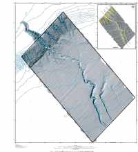 Map Sheet 1 -- Map only. Sea floor topography as shaded relief. 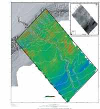 Map Sheet 2 -- Map only. Sea floor topography as shaded relief with backscatter intensity superimposed in color. 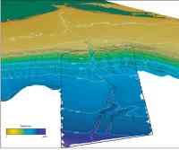 Figure 1. Perspective view, looking toward the northwest, of a portion of the continental shelf. 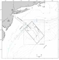 Figure 2. Map showing the location of the Hudson Canyon on the continental slope. 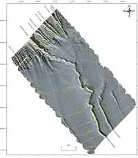 Figure 3. Map showing shaded-relief image of the sea floor. 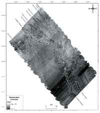 Figure 4. Map showing the backscatter intensity derived from the multibeam data. 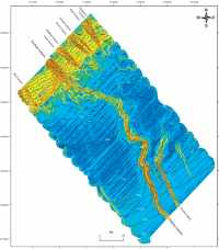 Figure 5. Map showing slope of the sea floor. 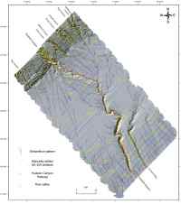 Figure 6. Map showing streamflow drainage for areas draining at least 1,000 pixels 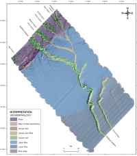 Figure 7. Geomorphic provinces identified in the survey area. 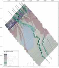 Figure 8. Map of sea-floor environments based on backscatter intensity, physiography, and subbottom characteristics 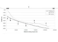 Figure 9. Profiles showing the morphology of Hudson Canyon. 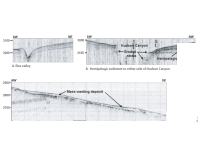 Figure 10. High-resolution seismic profiles. |

![]() U.S. Department of the Interior |
U.S. Geological Survey
U.S. Department of the Interior |
U.S. Geological Survey
URL: http://pubsdata.usgs.gov/pubs/of/2004/1441/html/interp.html
Page Contact Information: Publication Services
Page Last Modified: 00:06:36 Sun 13 Jan 2013