The sandy beaches and cliffed shores of Point Reyes National Seashore lie along the Northern Coast of California (Figure 1). Point Reyes and the neighboring San Francisco Bay Area are among the most complex and active geologic settings in the world (for more information on the geology of the San Francisco Bay region see: http://wrgis.wr.usgs.gov/wgmt/sfbay/index.html). Point Reyes National Seashore differs geologically from adjacent land in Marin County because the rocks composing Point Reyes Peninsula have traveled northwestward from Monterey Bay over the past 15 million years via the San Andreas and San Gregorio Faults (Galloway, 1977; Clark and Brabb, 1997) (Figure 2). Prior to this 150 km voyage, it is thought that Point Reyes Peninsula arrived in Monterey as an exotic terrane around 60 million years ago, then remained docked for over 40 million years before being carried up the coast (Locke, 1994;Clark and Brabb, 1997). The plate motion that pushes Point Reyes Peninsula to the northwest happens episodically. In 1906 a magnitude 7.7 earthquake (Waldo and others, 1993) shook San Francisco causing Point Reyes Peninsula to travel 20 feet to the northwest along the San Andreas Fault. Other geologic hazards that can result in immediate and major coastal and sea-level change in this region include landslides and tsunamis, but they are not directly addressed in the methodology of this report because their occurrence is episodic and the coastal impacts are difficult to predict. |
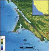 |
| Figure 1. Location of Point Reyes National Seashore, Northern California. Click on figure for larger image. |
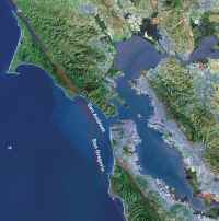 |
| Figure 2. Landsat TM satellite imagery of the San Francisco Bay Area showing major faults including the San Andreas and San Gregorio Faults. Click on figure for larger image. |
|