Western Coastal and Marine Geology
U.S. Geological Survey
Open-file Report 2006-1177
Benthic Habitat and Geologic Mapping of the outer Continental Shelf of North-Central CaliforniaVersion 1.0 Roberto J. Anima1, John L. Chin1, James E. Conrad1, and Nadine E. Golden2 |
||||||||
|
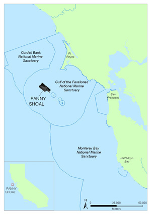
Figure 1. Location map of Fanny Shoal, outer Continental Shelf of North-Central California. To view a large version of Figure 1 in a new window, click on the image above. AbstractThe Fanny Shoal area is located between North Farallon Island and Cordell Bank approximately 40 miles west of San Francisco, California. The area lies within the Gulf of the Farallones National Marine Sanctuary (GFNMS) which is located just a few miles from San Francisco. The waters within the GFNMS are part of a nationally significant marine ecosystem encompassing a diversity of highly productive marine habitats. Protection of the living and cultural resources at the sites are administered by the National Oceanic and Atmospheric Administration (NOAA). The U.S. Geological Survey (USGS) in cooperation with the Golden Gate National Recreation Area (GGNRA) and NOAA, including the GFNMS, and Monterey Bay National Marine Sanctuary (MBNMS), collected side-scanning sonar, and underwater video data over three cruises in July of 2003, and April of 2004. The data are consolidated into a geographic information system (GIS) to produce benthic habitat and geologic maps that provide researchers and those involved in decision making with crucial, georeferenced geologic information that will aid in preserving the area's environment. Citation:
IntroductionThe Gulf of the Farallones National Marine Sanctuary (GFNMS) and the adjacent Cordell Bank and Monterey Bay National Marine Sanctuaries, were created under the National Marine Sanctuaries Act (NMSA) established in 1972 and administered by NOAA. The goal of the NMSA is to set aside and manage areas for resource protection, research, and to enhance public education. The GFNMS was designated in 1981 and encompasses 1,255 square miles between Bodega Bay and Rocky Point, an area of the California coast west of San Francisco Bay (fig. 1). The Gulf of the Farallones is rich in marine resources, including spawning grounds for commercially valued fish and is also a feeding and breeding area for marine mammals and seabirds. The USGS has conducted surveys in the area since 2003 as part of a project to map the marine geological environment and habitats in the area between the MBNMS and CBNMS. The Gulf of the Farallones was initially surveyed using side-scanning sonar in 1989 (Chin and others, 1997). The northern MBNMS was surveyed in 1994-96 (Ettreim and others, 1997, Anima and others, 1998). The Fanny Shoal survey is a continuation of these surveys with the goal of improving the understanding of the character of geology and surficial deposits of the continental shelf. The focus of this study is on the continental shelf, in areas generally shallower than 100 m (328 ft), between Cordell Bank and north Farallon Island. The project focused on mapping the seafloor with side-scanning sonar and collecting georeferenced video data in the survey areas to verify acoustic interpretations. The survey track lines were combined to form a mosaic of the entire study area. The seafloor geology was mapped on the mosaic as polygons interpreted by textural features found in the side-scanning sonar imaging. Polygon classification of bottom habitats were generated using a modified version of the classification scheme for seafloor habitats established by Greene and others (1999). Fanny Shoal lies between north Farallon Island and Whittenberg Bank, which are all roughly aligned with Cordell Bank to the north (fig. 1), covering an area of approximately 75 square kilometers. The shoals are comprised of resistant granitic and sedimentary rocks forming rugged outcrops that stand up to 40-50 m above the surrounding shelf, which is covered by fine-grained sand and silt with concentrations of coarse-grained sand and shell fragments in the form of sand waves and ridges of relatively low relief.
BathymetryThe continental Shelf area between Point Reyes and Fanny Shoal is gently sloping with water depths gradually increasing seaward. The water depth along the margins of the Fanny Shoal is approximately 110-120 meters becoming shallower over the shoal itself. The shallowest areas of the shoal are between 70-80 meters in depth.
Figure 2. Bathymetric map of Fanny Shoal with 10 meter contours. To view a large version of Figure 2 in a new window, click on the image above. Revisions and UpdatesThe GIS compilation will be revised and updated as new data become available. The data updates will be posted on the internet (online). Versions will be published online and links to each will be available at http://walrus.wr.usgs.gov/nearshorehab. To check on the version of our GIS look at Revision History. The hosting site may change in the future. If there is no forwarding link, go the USGS home page and search for keywords Gulf of the Farallones, or Cordell Bank marine habitat.
File and Data FormatsText files (.txt) on the web site may be viewed without special software. Hypertext mark-up language files (.html) require a browser such as Netscape Navigator or Internet Explorer. JPEG (.jpg) or TIFF (.tif) images may be viewed by many common image software packages. The data files require ESRI ArcExplorer, ArcView, or ArcInfo. ArcExplorer is an application that ESRI licenses without charge for Windows operating systems. ArcView and ArcInfo are licensed applications that must be purchased. The data were compiled in ArcInfo (versions 9.0 and 9.1) ESRI, 1982-2005), a commercial GIS, in the UTM Zone 10 coordinate system with datum NAD83. Raster data layers are in ArcInfo GRID format or are registered TIFF images. Point, line and polygon features are in ESRI shapefile format. Shapefiles were generated in geographic coordinates with datum NAD83. Each data layer is accompanied by Federal Geographic Data Committee (FGDC) compliant metadata and an overview map. AcknowledgmentsThe authors would like to thank the staffs of the GFNMS, MBMS, and CBNMS for their support of this project. We are especially gratefull to Jan Roletto, Jean de Marignac, Dan Howard, Dale Roberts, Irina Kogan, Fred Payne, and Gerry Hatcher for their assistance. The USGS Western Region Marine Facility expertly assisted with the mobilization, logistics and data acquisition. We would also like to thank the crew of the NOAA ship MacArthur II. This publication benefited from technical reviews by Jon Warrick and Jane A. Reid.
ReferencesAnima, R.J., Eittreim, S.L., Edwards, B.D., Stevenson, A.J., 2002, Nearshore morphology and late Quaternary geologic framework of the northern Monterey bay Marine Sanctuary: California. Marine Geology, v. 181, p. 35-54. Blondel, P., 1996, Segmentation of the Mid-Atlantic Ridge south of the Azores, based on acoustic classification of TOBI data, in MacLeod, C.J., Tyler, P.A., and Walker, C.L., eds., Tectonic, Magmatic, Hydrothermal and Biological Segmentation of Mid-Ocean Ridges: Boulder, CO, Geological Society Special Publication No. 118, p. 17-28. Blondel, P., and Murton, B.J., 1997, Handbook of Seafloor Sonar Imagery: West Sussex, England, 314 p. Chin, J.L., Karl, H.A., and Maher, N.M., 1997, Shallow surficial geology of the continental shelf, Gulf of the Farallones (CA), and its relationship to surficial seafloor characteristics: Marine Geology, v. 137, no. 3/4, p. 251-269. Clark, J.G., Brabb, E.E., Greene, H.G., and Ross, D.C., 1984, Geology of Point Reyes Peninsula and implications for San Gregorio history, in Crouch, J.K., and Bachman, S.B., eds., Tectonics and sedimentation along the California margin: Society of Economic Paleontologists and Mineralogists, Pacific Section, Field Trip Guidebook, April 18-24, 1984, book 38, p. 67-85. Cochrane, G.R., and Lafferty, K.D., 2002, Use of acoustic classification of sidescan sonar data for mapping benthic habitat in the Northern Channel Islands, California: Continental Shelf Research, v. 22, p. 683-690. Eittreim, L.S., Anima, R.J., Stevenson, A.J., 2002, Seafloor geology of the Monterey Bay area continental shelf. Marine Geology 181 (2002) 3-34. Galloway, A., 1977, Geology of the Point Reyes Peninsula, Marin County, California: Bulletin 202, California Div. of Mines and Geology, Sacramento, California. Greene, G.H., Yoklavich, M.M., Starr, R.M., O‘Connell, V.M., Wakefield, W.W., Sullivan, D.E., McRea, J.E., and Cailliet, G.M., 1999. A classification scheme for deep seafloor habitats: Oceanologica Acta, v. 22, p. 663-678. Shokr, M.E., 1991, Evaluation of second-order texture parameters for sea ice classification from radar images: Journal of Geophysical Research, v. 96, p. 10625-10640. *Any use of trade, product, or firm names is for descriptive purposes only and does not imply endorsement by the U.S. Government. For more information, contactRoberto J. Anima John L. Chin
|
Introduction Methods Results |
|||||||
|
||||||||

![]() U.S. Department of the Interior | U.S. Geological Survey
U.S. Department of the Interior | U.S. Geological Survey
URL: http://pubs.usgs.gov/of/2006/1177/
Page Contact Information: Michael Diggles
Page Last Modified: August 26, 2008