
Open-File Report 2007-1012
Geologic Interpretation and Multibeam Bathymetry of the Sea Floor in the Vicinity of the Race, Eastern Long Island Sound
![]() Title |
Introduction |
Setting |
Methods |
Results |
Discussion |
Data Catalog |
Acknowledgments |
References |
Figures |
Contacts
Title |
Introduction |
Setting |
Methods |
Results |
Discussion |
Data Catalog |
Acknowledgments |
References |
Figures |
Contacts
 |
||
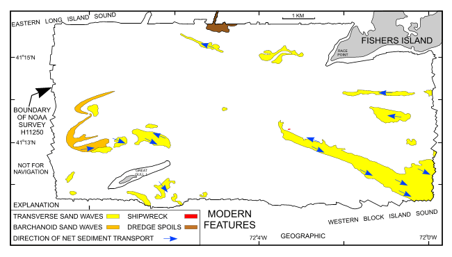
Figure 11. Interpretation of the modern features on the DTM. Arrows show directions of net sediment transport, based on sand wave asymmetry. Also shown are the locations of barchanoid and transverse sand waves, dredge spoils, and a shipwreck. | ||

![]() U.S. Department of the Interior |
U.S. Geological Survey
U.S. Department of the Interior |
U.S. Geological Survey
URL: http://pubsdata.usgs.gov/pubs/of/2007/1012/html/fig11.html
Page Contact Information: GS Pubs Web Contact
Page Last Modified: Tuesday, 07-May-2024 19:49:49 EDT


