| Title Page |
| Introduction |
| Setting |
| Methods |
| Results |
| Discussion |
| Data Catalog |
| Acknowledgments |
| References |
| List of Figures |
| Contacts |
| Disclaimers |
Digital terrain models (DTMs) produced from multibeam bathymetric data provide valuable base maps for marine geological interpretations (Todd and others, 1999; Mosher and Thomson, 2002; ten Brink and others, 2004; Poppe and others, 2006a, b, c, d). These maps help define the geological variability of the sea floor (one of the primary controls of benthic habitat diversity), improve our understanding of the processes that control the distribution and transport of bottom sediments and the distribution of benthic habitats and associated infaunal community structures, and provide a detailed framework for future research, monitoring, and management activities.
The bathymetric survey interpreted herein (National Oceanic and Atmospheric Administration (NOAA) survey H11250) covers roughly 94 km² of sea floor in an area where a depression along the Orient Point-Fishers Island segment of the Harbor Hill-Roanoke Point-Charlestown Moraine forms the Race, the eastern opening to Long Island Sound. The Race also divides easternmost Long Island Sound from northwestern Block Island Sound (fig. 1). This bathymetry has been examined in relation to seismic reflection data collected concurrently, as well as archived seismic profiles acquired as part of a long-standing geologic mapping partnership between the State of Connecticut and the U.S. Geological Survey (USGS). The objective of this work was to use these acoustic data sets to interpret geomorphological attributes of the sea floor, and to use these interpretations to better understand the Quaternary geologic history and modern sedimentary processes.
Click on figures for larger images.
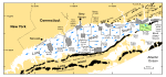 |
| Figure 1. Map showing location of the study area (green polygon). |
