

|
|
Coastal and Marine Geology Program
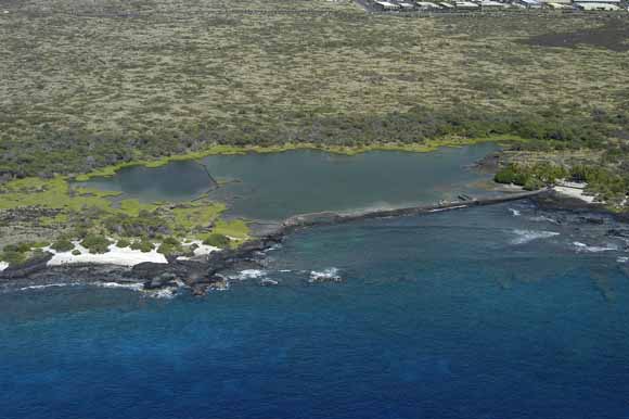
Oblique aerial photograph showing Kaloko Fishpond and a portion of the coastline of Kaloko-Honokōhau National Historical Park. Photograph courtesy of Brian Powers, Hawaiian Images Photography and Video, Kailua Kona, Hawai‘i
Geologic resource inventories of lands managed by the National Park Service (NPS) are important products for the parks and are designed to provide scientific information to better manage park resources. Park-specific geologic reports are used to identify geologic features and processes that are relevant to park ecosystems, evaluate the impact of human activities on geologic features and processes, identify geologic research and monitoring needs, and enhance opportunities for education and interpretation. These geologic reports are planned to provide a brief geologic history of the park and address specific geologic issues that link the park geology and the resource manager.
The Kona coast National Parks of the Island of Hawai‘i are intended to preserve the natural beauty of the Kona coast and protect significant ancient structures and artifacts of the native Hawaiians. Pu‘ukoholā Heiau National Historic Site (PUHE), Kaloko-Honokōhau National Historical Park (KAHO), and Pu‘uhonua O Honaunau National Historical Park (PUHO) are three Kona parks studied by the U.S. Geological Survey (USGS) Coastal and Marine Geology Team in cooperation with the National Park Service. This report is one of six related reports designed to provide geologic and benthic-habitat information for the three Kona parks. Each geology and coastal-landform report describes the regional geologic setting of the Hawaiian Islands, gives a general description of the geology of the Kona coast, and presents the geologic setting and issues for one of the parks. The related benthic-habitat mapping reports discuss the marine data and habitat classification scheme, and present results of the mapping program.
Kaloko-Honokōhau National Historical Park (KAHO) was established in 1978 in order to preserve and protect traditional native Hawaiian culture and cultural sites. The park is the site of an ancient Hawaiian settlement, occupies 469 ha and is considered a locale of considerable cultural and historical significance. Cultural resources include fishponds, petroglyphs and a heiau (religious site). The fishponds are also recognized as exceptional birding areas and are important wetlands for migratory birds. The ocean and reef have been designated as a Marine Area Reserve, where green sea turtles commonly come ashore to rest. The park is also a valuable recreational resource, with approximately 4 km of coastline and a protective cove ideal for snorkeling and swimming. KAHO park boundaries extend beyond the mean high tide line and include the adjacent marine environment. An accompanying report for KAHO presents the results of benthic habitat mapping of the offshore waters, from the shoreline to approximately 40 m water depth. Ground-water quality and potential downslope impacts created by development around the park are of concern to Park management.
Download this report as a 36-page PDF file (of2008-1191.pdf; 10.7 MB).
USGS Scientific Investigations Report 2006-5256, Benthic Habitats and Offshore Geological Resources of Kaloko-Honokōhau National Historical Park, Hawai‘i by Ann E. Gibbs, Susan A. Cochran, Joshua B. Logan, and Eric E. Grossman
For questions about the content of this report, contact Bruce Richmond
Download a free copy of the latest version of Adobe Reader.
|
Help |
PDF help |
Publications main page |
| Western Open-File Reports for 2008 |
| Geography | Coastal and Marine Geology
|

![]() U.S. Department of the Interior | U.S. Geological Survey
U.S. Department of the Interior | U.S. Geological Survey
URL: https://pubs.usgs.gov/of/2008/1191/
Page Contact Information: Michael Diggles
Page Created: February 10, 2009
Page Last Modified: February 18, 2009