

|
|
Coastal and Marine Geology Program
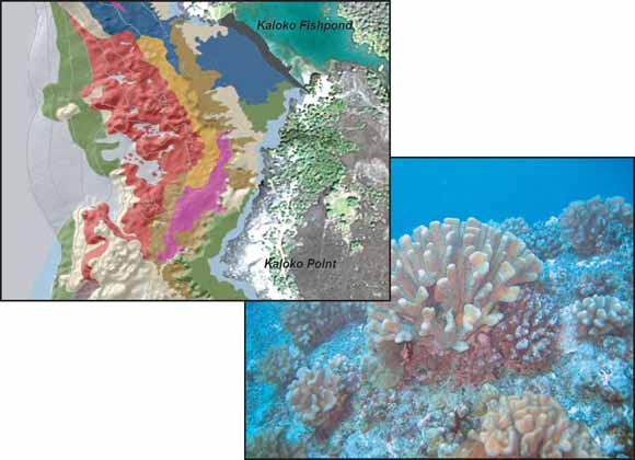
Left, enlarged portion of benthic habitat map showing Kaloko-Honokōhau National Historical Park shoreline. Right, underwater photograph shows example of coral reef habitat on the Kona coast of Hawai‘i.
Kaloko-Honokōhau National Historical Park (KAHO) is one of three National Park lands located along the western coast of the Island of Hawai‘i and the only one to include submerged lands and marine resources within its official boundaries. The park was established in 1978 and is 1,160 acres in size, including 596 acres of marine area. The submerged lands are currently managed by the State of Hawaii, Department of Land and Natural Resources, Division of Aquatic Resources (DLNR-DAR).
Marine resources located within KAHO include coral reef and habitat for many marine animals, including the green sea turtle and a variety of fish and invertebrates. In addition, many archeological, cultural, and recreational resources are located within the marine realm of the park. Potential threats and stressors to the modern marine environment include ground-water and surface-water contamination, invasive plants and algae, fishing pressure and use of monofilament gill nets (which can ensnare marine life or become tangled on reefs and be left behind as fishing debris), and visitor use impacts, such as scuba diving and snorkeling. Illegal dumping, oil releases, boat groundings, and other physical damage to reef resources are potential threats from users of the nearby harbor. Special issues of concern for the park include establishing baseline conditions of the offshore resources before the development of adjacent coastal lands.
Until this study, only a general knowledge of the distribution of benthic habitats and the characteristics of the offshore region of Kaloko-Honokōhau National Historical Park was available. In 2003, a collaborative project between the U.S. Geological Survey (USGS) Coastal and Marine Geology Program and the National Park Service (NPS) was initiated to develop detailed benthic-habitat classification maps for the marine lands within and adjacent to the park. The intent of this project is to provide baseline maps and a Geographic Information System (GIS) database and description of the biological and geological resources of these marine lands in order to facilitate the management, interpretation, and understanding of park resources.
A benthic-habitat classification map was created for the park using existing color aerial photography, Scanning Hydrographic Operational Airborne Lidar Survey (SHOALS) bathymetric data, georeferenced underwater video, and still photography. Individual habitat polygons were classified using five basic attributes: (1) major structure or substrate, (2) dominant structure, (3) major biologic cover on the substrate, (4) percentage of major biological cover, and (5) geographic zone. Additional information regarding geology, morphology, and coral species were also noted
Download this report as a 70-page PDF file (sir2006-5256.pdf; 11.2 MB; version 1.1, May 2016).
Read the metadata for the GIS data linked below. (KAHO_BenthicHabitats_meta.htm; 40 kB).
Download the GIS data for this report as a compressed file. This file includes the shapefile and associated metadata files for the benthic habitat map (KAHO_bhabs.zip; 1 MB).
Suggested citation:
Gibbs, A.E., Cochran, S.A., Logan, J.B, and Grossman, E.E., 2007, Benthic habitats and offshore geological resources of Kaloko-Honokohau National Historical park, Hawai`i (ver. 1.1, May 2016): U.S. Geological Survey Scientific Investigations Report 2006-5256, 62 p.
USGS Open-File Report 2008-1191, Geologic Resource Evaluation of Kaloko-Honokōhau National Historical Park, Hawai‘i Geology and Coastal Landforms by Bruce M. Richmond, Ann E. Gibbs, and Susan A. Cochran
For questions about the content of this report, contact Ann Gibbs
Download a copy of the latest version of Adobe Reader for free.
|
Help |
PDF help |
Publications main page |
| Western Scientific Investigations Reports |
| Geography | Coastal and Marine Geology
|

![]() U.S. Department of the Interior | U.S. Geological Survey
U.S. Department of the Interior | U.S. Geological Survey
URL: https://pubs.usgs.gov/sir/2006/5256/
Page Contact Information: Michael Diggles
Page Created: May 21, 2007
Page Last Modified: February 18, 2009