U.S. Geological Survey Open-File Report 2008-1288
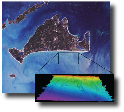
AbstractThe U.S. Geological Survey Woods Hole Science Center conducted a nearshore geophysical survey offshore of the southern coast of Martha's Vineyard, in the vicinity of the Martha's Vineyard Coastal Observatory in 2007. This mapping program was part of a larger research effort supporting the Office of Naval Research Ripples Directed-Research Initiative studies at Martha's Vineyard Coastal Observatory designed to improve our understanding of coastal sediment-transport processes. The survey was conducted aboard the Megan T. Miller August 9-13, 2007. The study area covers 35 square kilometers from about 0.2 kilometers to 5 kilometers offshore of the south shore of Martha's Vineyard, and ranges in depth from ~6 to 24 meters. The geophysical mapping utilized the following suite of high-resolution instrumentation to map the surficial sediment distribution, bathymetry, and sub-surface geology: a dual-frequency 100/500 kilohertz sidescan-sonar system, 234 kilohertz interferometric sonar, and 500 hertz -12 kilohertz chirp subbottom profiler. These geophysical data will be used to provide initial conditions for wave and circulation modeling within the study area. |
First posted January 2010 For additional information contact: Part or all of this report is presented in Portable Document Format (PDF); the latest version of Adobe Reader or similar software is required to view it. Download the latest version of Adobe Reader, free of charge. |
Denny, J.F., Danforth, W.W., Foster, D.S., and Sherwood, C.R., 2009, Geophysical data collected off the south shore of Martha's Vineyard, Massachusetts: U.S. Geological Survey Open-File Report 2008-1288, (Also available at https://pubs.usgs.gov/of/2008/1288/.)
Abstract
Introduction
Data Acquisition and Processing Overview
Field Program
Swath Bathymetry
Sidescan Sonar
Chirp Seismic Reflection
Supplemental Data: Sediment Samples
Geographic Information System Data Catalog
Data Access
Raster and Vector Data Description
Data Preview
Acknowledgments
References Cited

![]() U.S. Department of the Interior |
U.S. Geological Survey
U.S. Department of the Interior |
U.S. Geological Survey
URL: https://pubsdata.usgs.gov/pubs/of/2008/1288/
Page Contact Information: Contact USGS
Page Last Modified: Wednesday, 07-Dec-2016 21:27:08 EST
