U.S. Geological Survey Open-File Report 2009-1042
National Assessment of Historical Shoreline Change: A Pilot Study of Historical Coastal Bluff Retreat in the Great Lakes, Erie, Pennsylvania
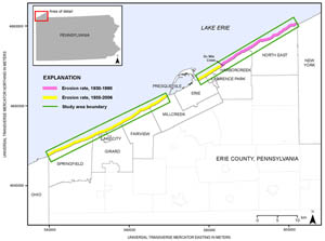
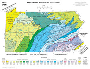
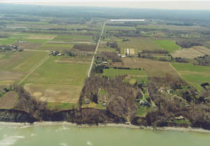
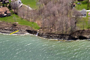
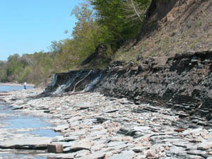
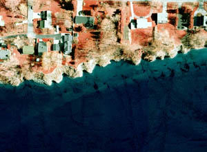
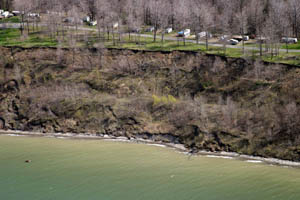
The coastal bluffs along Pennsylvania’s Lake Erie shoreline in Erie County (fig. 3) are located in the Eastern Lake Section of the Central Lowland Province (Knuth and others, 1981; Pennsylvania Department of Conservation and Natural Resources, 2000) (fig. 4). The region is north and west of the Appalachian Plateau Province. The escarpment marking the division between the provinces is visible from most areas of the coastal zone (fig. 5). Surface drainage is from the lowland north to Lake Erie and is locally controlled by glacial deposits. The physiography and topography are a function of geologic structure, bedrock strata, and Pleistocene glaciation (Knuth and others, 1981). A series of northwest-sloping, lake-parallel, low-relief ridges make up the Eastern Lake Section of the Central Lowland Province. The ridges are unconsolidated sands and gravels that were deposited during the most recent deglaciation of the area about 18,000 years ago. The ridge bordering Lake Erie at one time sloped gently into the lake. Erosion of the shoreline has resulted in a southeastward retreat of the lake-land interface and the formation of steep bluffs adjacent to the lake. The coastal bluffs of the Great Lakes are underlain by bedrock that is exposed at the base in some areas (Sevan and Braun, 1997). Quaternary continental glaciation produced several ice-sheet advances into northwestern Pennsylvania (Knuth and others, 1981). During each advance, materials generally consisting of glacial till were transported from the northeast and deposited locally. The tills on the bluffs of Erie County are made up of fine-grained till that overlies the Devonian shales, which were partially eroded prior to the glacial deposition, producing an irregular surface and intermittent exposures along the shore (Knuth and others, 1981). Overlying the glacial tills and visible on exposed bluff stratigraphy are lacustrine, strand, and alluvial deposits. Lacustrine deposits are the result of proglacial lakes depositing thinly interbedded clayey silt and silty clay. The strand deposits are also the result of proglacial lakes in the form of ancient shorelines of silty sand, sand, and sand and gravel. In many places the bluff stratigraphy is obscured by an accumulation of colluvium, which forms large debris fans on the lower bluff face that are commonly covered with pioneer vegetation (Knuth and others, 1981). Bedrock exposures at the base of the bluffs in the coastal reach east of Presque Isle and locally west of Presque Isle (figs. 6 and 7) are of the Canadaway Formation, Middle Upper Devonian in age (Pennsylvania Department of Conservation and Natural Resources, 1990). The bedrock along the base of the bluff influences coastal processes in three ways. First, in areas of sand deficiency, precluding beach development, the bedrock exposures act as a natural seawall with respect to wave energy. The reflection of wave energy removes sediment from the nearshore and deposits it farther offshore (Knuth and others, 1981). As a result, sediment that might have been available is removed from the longshore transport system, exacerbating sediment deficits and precluding beach development. Second, exposures of bedrock in the zone of breaking waves promotes "plucking," which produces shingles from a few centimeters to 1 m in size. This eroding bedrock is an important source of siltstone gravels (Clemens, 1976). The capacity of the littoral transport system to move those shingles substantial distances is evidenced by the volume of shingles seen on Presque Isle Beaches, as much as several kilometers downdrift from the nearest bedrock exposures. The shingles tend to remain in the nearshore (fig. 7) as a result of the large grain size, providing material for beach building as they weather. Third, linear joints in the bedrock that are exposed to storm waves expand by hydraulic force to produce the incised or cuspate morphology seen in the bluffs east of Presque Isle (fig. 8). On a larger scale, these incisions produce headland-cove morphology, and pocket beaches tend to form in the sheltered areas (Knuth and others, 1981). In most cases, the small pocket beaches are the only beaches along the reach from the City of Erie east to Six Mile Creek (fig. 3). Pennsylvania’s bluffs range in height from 1.5 to 60 m. Without wave contact at the base, bluffs are inherently stable, with only minimal loss of soil due to gravity-induced bluff creep, usually visible only at the bluff crest. Heavy ground-water flows exiting the bluff face between the lakeward tilted glacial till (clay) layer and permeable lacustrine sands and gravels supply adequate moisture to support trees and a dense mat of vegetative cover. The bluff consists mostly of a clay-rich glacial till and because the roots of the forested vegetation mat are unable to penetrate the clay substrate, the mat simply lies on the bluff face as a mat of roots and organic mass. There is a delicate balance between the root mat and the ground water, which exits the upper bluff face above the glacial till. The ground water moves down through the mat, nurturing vegetative growth. Within a healthy stabilized bluff, the ground water is completely absorbed into the root mat and the system is balanced (fig. 9a). When lake levels are high or during large storms, waves can reach the base of the bluff, causing extensive erosion of the unconsolidated soils and unprotected vegetation mat (fig. 9b). When the vegetation mat is removed from the base of the bluff, the upper areas of the bluff face become unstable, causing the upper vegetation mat to break apart, slip, and collapse in sections to the base of the bluff (fig. 9c). Wave erosion will continue to remove collapsed vegetation-mat sections until all debris is eroded from the base of the bluff. Steep bluff slopes denuded of vegetation are further susceptible to other erosion processes (ground-water flow, surface-water flow, wind, and rain) (fig. 9d) and will continue to recede landward until an angle of repose is established (fig. 9e). The most common type of bluff retreat along Lake Erie is in the form of soil slides. There are two common types of slides—rotational and translational. A rotational slide fails along a concavely curved rupture (see fig. 2). The resulting slump surface is spoon-shaped and is rotational about an axis that is parallel to the slope (Varnes, 1978). The classic slump is common in homogeneous materials. Rotational slumps tend to occur in clayey soils and not in sands. In translational slides, the mass of soil progresses down and out along a more or less planar surface and shows no rotational or backward tilting characteristics of a slump (Varnes, 1978). Translational slides (fig. 10) tend to move as one mass, and the separation line is somewhat linear in appearance. Along Lake Erie, most bluff instability starts with wave contact at the base. Ground water flow is common and is a secondary erosional process in creating bluff instability and in advanced stages of bluff recession. CRM has determined through field experience, observation, and project trial and error that, in most cases, ground-water flow is not a catalyst of bluff recession but is simply an ambient hydraulic feature that becomes visible when vegetation is removed from the bluff profile. Erosion driven by both ground water (elevated pore pressure) and surface-water overflow is necessary to bring the steep bluff profile back to the angle of repose. Groundwater is also necessary on reposed bluff profiles to promote rapid revegetation of bluff slopes. |

![]() U.S. Department of the Interior |
U.S. Geological Survey
U.S. Department of the Interior |
U.S. Geological Survey
URL: https://pubsdata.usgs.gov/pubs/of/2009/1042/html/geology.html
Page Contact Information: Contact USGS
Page Last Modified: Monday, 03-Jun-2019 11:37:05 EDT