Open-File Report 2010-1007
By L.J. Poppe,¹ K.Y. McMullen,¹ S.D. Ackerman,¹ D.S. Blackwood,¹ B.J. Irwin,¹ J.D. Schaer,² P.G. Lewit,² and E.F. Doran³
1Coastal and Marine Geology Program, U.S. Geological Survey, Woods Hole, MA 02543
2Office of Coast Survey, NOAA, Norfolk, VA 23510
3Marine Operations Center–Atlantic, NOAA, Norfolk, VA 23510
4Connecticut Department of Environmental Protection, Hartford, CT 06106
ABSTRACT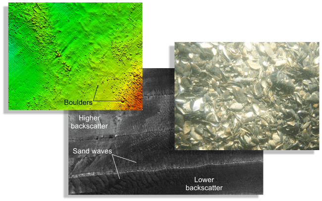
Gridded multibeam bathymetry and sidescan-sonar imagery together cover approximately 21.6 square kilometers of sea floor in eastern Long Island Sound offshore of Rocky Point, New York. Although originally collected for charting purposes during National Oceanic and Atmospheric Administration hydrographic survey H11251, these acoustic data, and the sea-floor sampling and photography stations subsequently occupied to verify them, (1) show the composition and terrain of the seabed, (2) provide information on sediment transport and benthic habitat, and (3) are part of an expanding series of studies that provide a fundamental framework for research and resource management (for example, cables, pipelines, and dredging) activities in this major East Coast estuary. |
Posted August 2010 For additional information contact: Part or all of this report is presented in Portable Document Format (PDF); the latest version of Adobe Reader or similar software is required to view it. Download the latest version of Adobe Reader, free of charge. |
Poppe, L.J., McMullen, K.Y., Ackerman, S.D., Blackwood, D.S., Irwin, B.J., Schaer, J.D., Lewit, P.G, and Doran, E.F., 2010, Sea-floor geology and character offshore of Rocky Point, New York: U.S. Geological Survey Open-File Report 2010–1007, DVD-ROM. (Also available at https://pubs.usgs.gov/of/2010/1007/.)
Abstract
Introduction
Setting
Methods
Bathymetry
Sidescan Sonar
Sediments Distribution
Bottom Photography
GIS Data Catalog
Summary
Acknowledgments
References
Contacts

![]() U.S. Department of the Interior |
U.S. Geological Survey
U.S. Department of the Interior |
U.S. Geological Survey
URL: https://pubsdata.usgs.gov/pubs/of/2010/1007/
Page Contact Information: Contact USGS
Page Last Modified: Wednesday, 07-Dec-2016 22:37:58 EST
