U.S. Geological Survey Open-File Report 2010–1100
Surficial Geology of the Sea Floor in Long Island Sound Offshore of Orient Point, New York
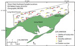
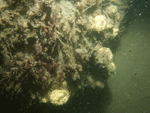
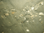
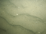
Sediments were sampled at 14 of the 26 stations in the study area. Because samples could not be collected at the 12 remaining stations, these stations were classified based on video and photographic data. Sand was present at 11 of the stations, with mean sizes ranging from about 1 to 3 phi. Gravel was present at 11 of the stations, most of which were classified visually. Four stations exhibited gravelly sediment ranging from 12 to 40 percent gravel. Sediment DistributionGravel and gravelly sediments were found where higher backscatter and boulders are present on the sidescan-sonar image, such as at stations 9 and 13 (figs. 20 , 21, and 22); sand was found where lower backscatter and sand waves are present, such as at stations 12 and 22 (figs. 20, 23, and 24). Strong currents in the study area presumably contribute to the lack of mud on the surface of the sea floor by preventing fine-grained sediment from being deposited. Sediment DataThe sediment grain-size dataset provided here contains information on the collection, location, description, and texture of sediments at 26 stations occupied during the R/V Rafael cruise 2010-010 (fig. 20). All analyses were conducted in the sedimentation laboratory at the USGS Woods Hole Coastal and Marine Science Center, Woods Hole, MA. Records without textural data and statistics (those with no-data values of -9999) are based on visual descriptions. The basic structure of the data is a flat-file format, a matrix where records are rows representing individual samples and the columns contain sample- and station-specific information. This matrix consists of 42 fields, which are defined in the Data Dictionary below. The sediment data are provided in three formats: a shapefile, Microsoft Excel spreadsheet, and comma-delimited ASCII text file along with metadata in a Zip file located in the Data Catalog section of this report. Data DictionaryAn integral part of any database is the dictionary that explains its structure and content. The dictionary contains a list of the fields and definitions of parameters measured. Data utilization is facilitated by reference to this compilation because it defines abbreviations and lists field names, as follows: LABNO - Unique sample identifier assigned in the laboratory STATIONID - Sample name or number assigned in the field PROJECT - Project under which samples were collected or data generated CRUISEID - Name or number of cruise on which sample was collected or station occupied PRINCIPAL - Name of principal investigator LATITUDE - Latitude in decimal degrees (north latitudes are positive values) LONGITUDE - Longitude in decimal degrees (west longitudes are negative values) DEPTH_M - Depth of water overlying sediment at the time of sampling, measured by a hull-mounted fathometer, corrected for draft but not corrected for tides, in meters T_DEPTH - Top depth of the sample below the sediment-water interface, in centimeters B_DEPTH - Bottom depth of the sample below the sediment-water interface, in centimeters DEVICE - Device used to collect the sample MONTH - Number of calendar month during which the sample was collected DAY - Calendar day on which the sample was collected YEAR - Calendar year during which the sample was collected WEIGHT - Dry weight of sample, in grams ZGRAVEL - Gravel content in percent dry weight of the sample (particles with nominal diameters greater than 2 millimeters; -1 phi and larger) ZSAND - Sand content in percent dry weight of the sample (particles with nominal diameters less than 2 millimeters but greater than or equal to 0.0625 millimeter; 0 through 4 phi, inclusive) ZSILT - Silt content in percent dry weight of the sample (particles with nominal diameters less than 0.0625 millimeter but greater than or equal to 0.004 millimeter; 5 through 8 phi, inclusive) ZCLAY - Clay content in percent dry weight of the sample (particles with nominal diameters less than 0.004 millimeter; 9 phi and smaller) SEDCLASS - Sediment description based on a rigorous definition (Shepard, 1954) MEDIAN - Middle point in the grain-size distribution, in phi units MEAN - Average value in the grain-size distribution, in phi units STDDEV - Standard deviation (root mean square of the deviations) of the grain-size distribution, in phi units (that is, sorting) SKEWNESS - Deviation from symmetrical form of the grain-size distribution KURTOSIS - Degree of curvature near the mode of the grain-size distribution PHI_11 - Weight percent of the sample in the 11-phi fraction (nominal diameter of particles greater than or equal to 0.0005 millimeter but less than 0.001 millimeter); fine clay PHI_10 - Weight percent of the sample in the 10-phi fraction (nominal diameter of particles greater than or equal to 0.001 millimeter but less than 0.002 millimeter); medium clay PHI_9 - Weight percent of the sample in the 9-phi fraction (nominal diameter of particles greater than or equal to 0.002 millimeter but less than 0.004 millimeter); coarse clay PHI_8 - Weight percent of the sample in the 8-phi fraction (nominal diameter of particles greater than or equal to 0.004 millimeter but less than 0.008 millimeter); very fine silt PHI_7 - Weight percent of the sample in the 7-phi fraction (nominal diameter of particles greater than or equal to 0.008 millimeter but less than 0.016 millimeter); fine silt PHI_6 - Weight percent of the sample in the 6-phi fraction (nominal diameter of particles greater than or equal to 0.016 millimeter but less than 0.031 millimeter); medium silt PHI_5 - Weight percent of the sample in the 5-phi fraction (nominal diameter of particles greater than or equal to 0.031 millimeter but less than 0.0625 millimeter); coarse silt PHI_4 - Weight percent of the sample in the 4-phi fraction (nominal diameter of particles greater than or equal to 0.0625 millimeter but less than 0.125 millimeter); very fine sand PHI_3 - Weight percent of the sample in the 3-phi fraction (nominal diameter of particles greater than or equal to 0.125 millimeter but less than 0.25 millimeter); fine sand PHI_2 - Weight percent of the sample in the 2-phi fraction (nominal diameter of particles greater than or equal to 0.25 millimeter but less than 0.5 millimeter); medium sand PHI_1 - Weight percent of the sample in the 1-phi fraction (nominal diameter of particles greater than or equal to 0.5 millimeter but less than 1 millimeter); coarse sand PHI_0 - Weight percent of the sample in the 0-phi fraction (nominal diameter of particles greater than or equal to 1 millimeter but less than 2 millimeters); very coarse sand PHIM1 - Weight percent of the sample in the -1-phi fraction (nominal diameter of particles greater than or equal to 2 millimeters but less than 4 millimeters); very fine pebbles (granules) PHIM2 - Weight percent of the sample in the -2-phi fraction (nominal diameter of particles greater than or equal to 4 millimeters but less than 8 millimeters); fine pebbles PHIM3 - Weight percent of the sample in the -3-phi fraction (nominal diameter of particles greater than or equal to 8 millimeters but less than 16 millimeters); medium pebbles PHIM4 - Weight percent of the sample in the -4-phi fraction (nominal diameter of particles greater than or equal to 16 millimeters but less than 32 millimeters); coarse pebbles PHIM5 - Weight percent of the sample in the -5-phi fraction (nominal diameter of particles greater than or equal to 32 millimeters); very coarse pebbles to boulders. |