
|
Data in this report are available as downloadable files based on the ten geomorphic regions that make up the New England and Mid-Atlantic study area. The index maps highlight areas of shoreline coverage in yellow and indicate the extent of each region. All vector data are delivered as ESRI shapefiles in the geographic coordinate system (WGS84) and distributed with Federal Geographic Data Committee (FGDC) compliant metadata in Extensible Markup Language (*.xml) format. Tabular data are delivered as dBase IV (*.dbf) structured files which can be read with ESRI ArcGIS software as well as many other available spreadsheet programs. Metadata are also provided for all spatial and tabular data in text (*.txt) and FGDC Classic (*.html) format. ESRI ArcCatalog 9.x can also be used to examine the metadata in a variety of additional formats.
This report includes all of the files necessary to perform shoreline change analyses using the Digital Shoreline Analysis System (DSAS) software. Please refer to Thieler and others (2009) for information about the DSAS software application that was used to perform the rate calculation methods, which are discussed at length in the full report on the National Assessment of Shoreline Change for the New England and Mid-Atlantic Coasts (Hapke and others, 2010).
The following files are available for download for each geomorphic region (see index maps):
- Compiled shorelines from multiple sources which are attributed within each dataset and included in the metadata.
- Offshore baseline used for generating shore-normal transects in DSAS
- Long-term transect file with rates
- Short-term transect file with rates
- Shoreline uncertainty table containing the lidar positional uncertainty, bias values for the MHW - HWL shoreline proxy offsets, and the uncertainty associated with each bias value.
Data layers can be downloaded individually using the table below. Individual layers are provided as WinZip files. If WinZip® is not currently installed on the local system, go to WinZip® (http://www.winzip.com) to download the latest version.
New England
New England North
| Click on figure for larger image. |
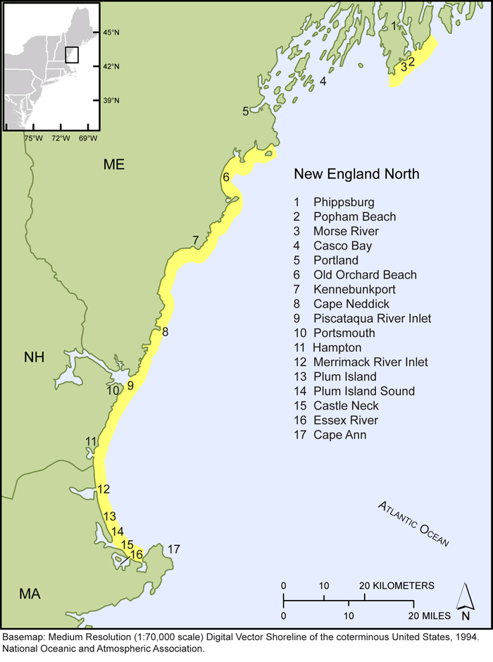 |
| Figure 1. Map of Northern New England shoreline showing specific shoreline locations compiled for this study. |
|
File |
Description |
Metadata |
Download |
NewEnglandN_shorelines.shp |
Compiled shorelines for New England North region |
.html
.txt |
.zip
(582 KB) |
NewEnglandN_baseline.shp |
Offshore baseline for generating shore-normal transects in DSAS |
.html
.txt |
.zip
(10 KB) |
NewEnglandN_LT.shp |
Shore-normal transects and associated long-term rate calculations |
.html
.txt |
.zip
(155 KB) |
NewEnglandN_ST.shp |
Shore-normal transects and associated short-term rate calculations |
.html
.txt |
.zip
(38 KB) |
NewEnglandN_shorelines_uncertainty.dbf |
Shoreline uncertainty table |
.html
.txt |
.zip
( 34 KB) |
Greater Boston
| Click on figure for larger image. |
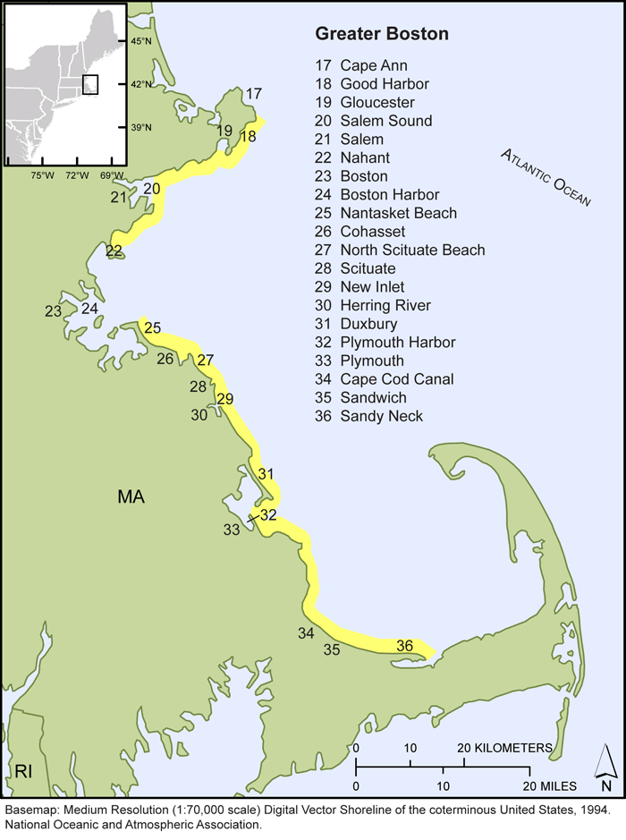 |
| Figure 2. Map of the Greater Boston, MA shoreline showing specific shoreline locations compiled for this study. |
|
File |
Description |
Metadata |
Download |
GreaterBoston_shorelines.shp |
Compiled shorelines for Greater Boston region |
.html
.txt |
.zip
(1.5 MB) |
GreaterBoston_baseline.shp |
Offshore baseline for generating shore-normal transects in DSAS |
.html
.txt |
.zip
(8 KB) |
GreaterBoston_LT.shp |
Shore-normal transects and associated long-term rate calculations |
.html
.txt |
.zip
(198 KB) |
GreaterBoston_ST.shp |
Shore-normal transects and associated short-term rate calculations |
.html
.txt |
.zip
(114 KB) |
GreaterBoston_shorelines_uncertainty.dbf |
Shoreline uncertainty table |
.html
.txt |
.zip
(37 KB) |
Cape Cod
| Click on figure for larger image. |
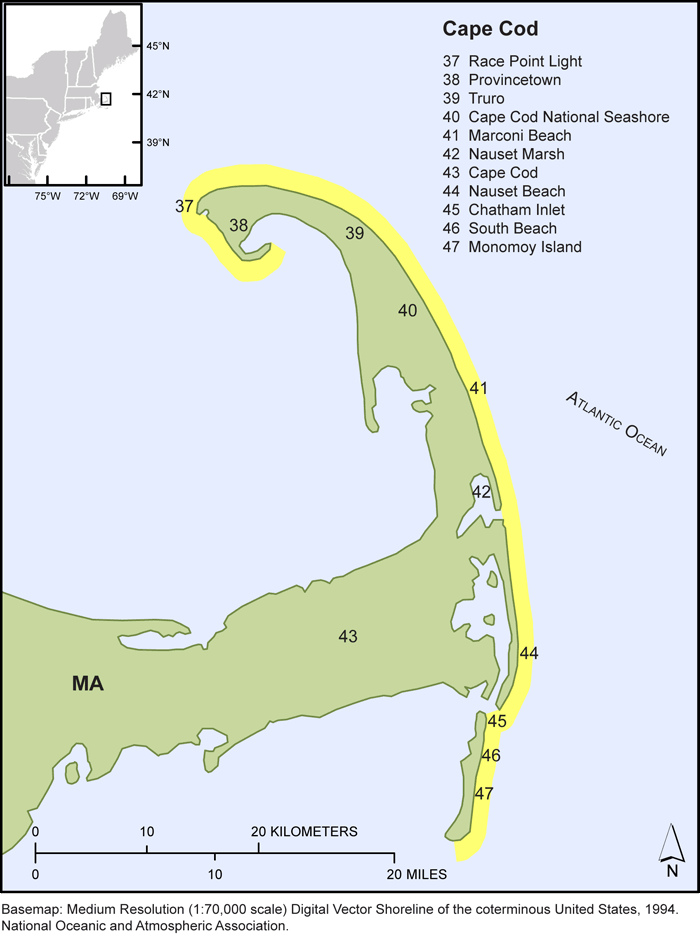 |
| Figure 3. Map of the Cape Cod, MA shoreline showing specific shoreline locations compiled for this study. |
|
File |
Description |
Metadata |
Download |
CapeCod_shorelines.shp |
Compiled shorelines for Cape Cod region |
.html
.txt |
.zip
(468 KB) |
CapeCod_baseline.shp |
Offshore baseline for generating shore-normal transects in DSAS |
.html
.txt |
.zip
(7 KB) |
CapeCod_LT.shp |
Shore-normal transects and associated long-term rate calculations |
.html
.txt |
.zip
(152 KB) |
CapeCod_ST.shp |
Shore-normal transects and associated short-term rate calculations |
.html
.txt |
.zip
(138 KB) |
CapeCod_shorelines_uncertainty.dbf |
Shoreline uncertainty table |
.html
.txt |
.zip
(29 KB ) |
Massachusetts Islands
| Click on figure for larger image. |
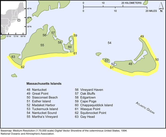 |
| Figure 4. Map of Marthas Vineyard and Nantucket, MA shoreline showing specific shoreline locations compiled for this study. |
|
File |
Description |
Metadata |
Download |
MA_Islands_shorelines.shp |
Compiled shorelines for MA Islands region |
.html
.txt |
.zip
(794 KB) |
MA_Islands_baseline.shp |
Offshore baseline for generating shore-normal transects in DSAS |
.html
.txt |
.zip
(10 KB) |
MA_Islands_LT.shp |
Shore-normal transects and associated long-term rate calculations |
.html
.txt |
.zip
(155 KB) |
MA_Islands_ST.shp |
Shore-normal transects and associated short-term rate calculations |
.html
.txt |
.zip
(78 KB) |
MA_Islands_shorelines_uncertainty.dbf |
Shoreline uncertainty table |
.html
.txt |
.zip
(31 KB) |
New England South
| Click on figure for larger image. |
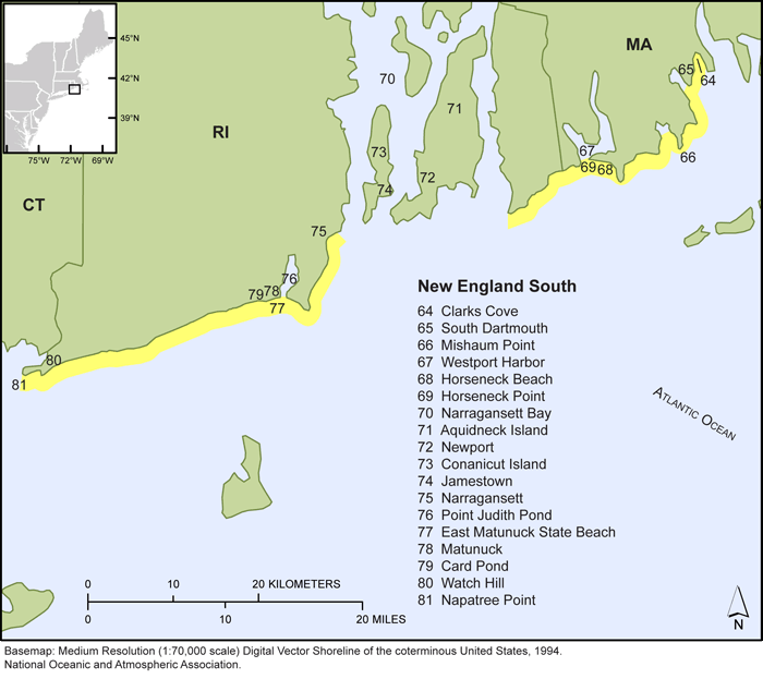 |
| Figure 5. Map of the Southern Massachusetts and Rhode Island shoreline showing specific shoreline locations compiled for this study. |
|
File |
Description |
Metadata |
Download |
NewEnglandS_shorelines.shp |
Compiled shorelines for New England South region |
.html
.txt |
.zip
(766 KB) |
NewEnglandS_baseline.shp |
Offshore baseline for generating shore-normal transects in DSAS |
.html
.txt |
.zip
(10 KB) |
NewEnglandS_LT.shp |
Shore-normal transects and associated long-term rate calculations |
.html
.txt |
.zip
(135 KB) |
NewEnglandS_ST.shp |
Shore-normal transects and associated short-term rate calculations |
.html
.txt |
.zip
(95 KB) |
NewEnglandS_shorelines_uncertainty.dbf |
Shoreline uncertainty table |
.html
.txt |
.zip
(27 KB) |
Mid-Atlantic
Long Island
| Click on figure for larger image. |
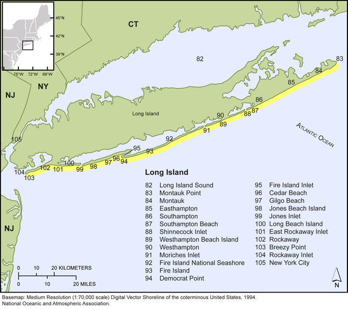 |
| Figure 6. Map of the Long Island, NY shoreline showing specific shoreline locations compiled for this study. |
|
File |
Description |
Metadata |
Download |
LongIsland_shorelines.shp |
Compiled shorelines for Long Island region |
.html
.txt |
.zip
(1.4 MB) |
LongIsland_baseline.shp |
Offshore baseline for generating shore-normal transects in DSAS |
.html
.txt |
.zip
(14 KB) |
LongIsland_LT.shp |
Shore-normal transects and associated long-term rate calculations |
.html
.txt |
.zip
(298 KB) |
LongIsland_ST.shp |
Shore-normal transects and associated short-term rate calculations |
.html
.txt |
.zip
(249 KB) |
LongIsland_shorelines_uncertainty.dbf |
Shoreline uncertainty table |
.html
.txt |
.zip
(53 KB) |
New Jersey North
| Click on figure for larger image. |
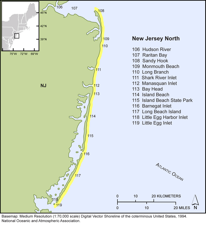 |
| Figure 7. Map of the northern New Jersey shoreline showing specific shoreline locations compiled for this study. |
|
File |
Description |
Metadata |
Download |
NewJerseyN_shorelines.shp |
Compiled shorelines for New Jersey North region |
.html
.txt |
.zip
(789 KB) |
NewJerseyN_baseline.shp |
Offshore baseline for generating shore-normal transects in DSAS |
.html
.txt |
.zip
(7 KB) |
NewJerseyN_LT.shp |
Shore-normal transects and associated long-term rate calculations |
.html
.txt |
.zip
(192 KB) |
NewJerseyN_ST.shp |
Shore-normal transects and associated short-term rate calculations |
.html
.txt |
.zip
(163 KB) |
NewJerseyN_shorelines_uncertainty.dbf |
Shoreline uncertainty table |
.html
.txt |
.zip
(38 KB) |
New Jersey South
| Click on figure for larger image. |
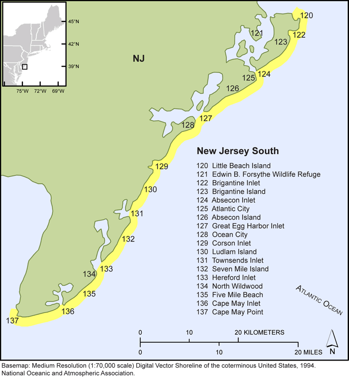 |
| Figure 8. Map of the southern New Jersey shoreline showing specific shoreline locations compiled for this study. |
|
File |
Description |
Metadata |
Download |
NewJerseyS_shorelines.shp |
Compiled shorelines for New Jersey South region |
.html
.txt |
.zip
(807 KB) |
NewJerseyS_baseline.shp |
Offshore baseline for generating shore-normal transects in DSAS |
.html
.txt |
.zip
(10 KB) |
NewJerseyS_LT.shp |
Shore-normal transects and associated long-term rate calculations |
.html
.txt |
.zip
(144 KB) |
NewJerseyS_ST.shp |
Shore-normal transects and associated short-term rate calculations |
.html
.txt |
.zip
(112 KB) |
NewJerseyS_shorelines_uncertainty.dbf |
Shoreline uncertainty table |
.html
.txt |
.zip
(29 KB) |
Delmarva North
| Click on figure for larger image. |
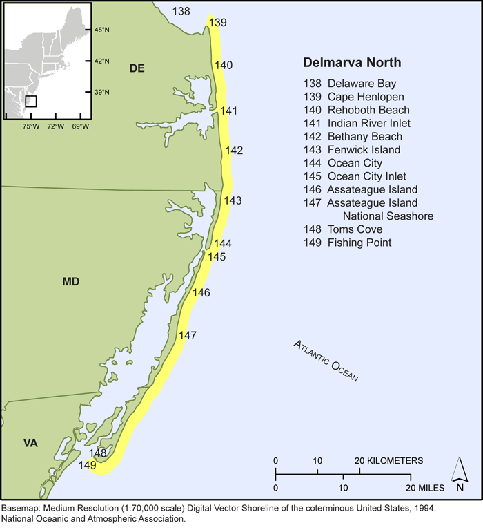 |
| Figure 9. Map of the Delaware, Maryland, and northern Virgina shoreline showing specific shoreline locations compiled for this study. |
|
File |
Description |
Metadata |
Download |
DelmarvaN_shorelines.shp |
Compiled shorelines for Delmarva North region |
.html
.txt |
.zip
(434 KB) |
DelmarvaN_baseline.shp |
Offshore baseline for generating shore-normal transects in DSAS |
.html
.txt |
.zip
(7 KB) |
DelmarvaN_LT.shp |
Shore-normal transects and associated long-term rate calculations |
.html
.txt |
.zip
(194 KB) |
DelmarvaN_ST.shp |
Shore-normal transects and associated short-term rate calculations |
.html
.txt |
.zip
(182 KB) |
DelmarvaN_shorelines_uncertainty.dbf |
Shoreline uncertainty table |
.html
.txt |
.zip
(24 KB) |
Delmarva South/Southern Virginia
| Click on figure for larger image. |
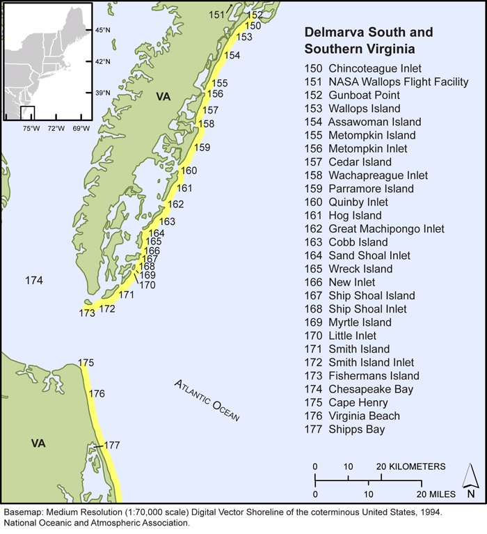 |
| Figure 10. Map of the southern Virgina shoreline showing specific shoreline locations compiled for this study. |
|
File |
Description |
Metadata |
Download |
DelmarvaS_SVA_shorelines.shp |
Compiled shorelines for Delmarva South/Southern Virginia region |
.html
.txt |
.zip
(613 KB) |
DelmarvaS_SVA_baseline.shp |
Offshore baseline for generating shore-normal transects in DSAS |
.html
.txt |
.zip
(7 KB) |
DelmarvaS_SVA_LT.shp |
Shore-normal transects and associated long-term rate calculations |
.html
.txt |
.zip
(234 KB) |
DelmarvaS_SVA_ST.shp |
Shore-normal transects and associated short-term rate calculations |
.html
.txt |
.zip
(195 KB) |
DelmarvaS_SVA__shorelines_uncertainty.dbf |
Shoreline uncertainty table |
.html
.txt |
.zip
(44 KB) |
|


