Open-File Report 2010-1146
ABSTRACT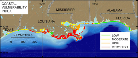
A coastal vulnerability index (CVI) was used to map the relative vulnerability of the coast to future sea-level rise along the Northern Gulf of Mexico from Galveston, TX, to Panama City, FL. The CVI ranks the following in terms of their physical contribution to sea-level rise-related coastal change: geomorphology, regional coastal slope, rate of relative sea-level rise, historical shoreline change rate, mean tidal range, and mean significant wave height. The rankings for each variable are combined and an index value is calculated for 1-kilometer grid cells along the coast. The CVI highlights those regions where the physical effects of sea-level rise might be the greatest. The CVI assessment presented here builds on an earlier assessment conducted for the Gulf of Mexico. Recent higher resolution shoreline change, land loss, elevation, and subsidence data provide the foundation for a better assessment for the Northern Gulf of Mexico. The areas along the Northern Gulf of Mexico that are likely to be most vulnerable to sea-level rise are parts of the Louisiana Chenier Plain, Teche-Vermillion Basin, and the Mississippi barrier islands, as well as most of the Terrebonne and Barataria Bay region and the Chandeleur Islands. These very high vulnerability areas have the highest rates of relative sea-level rise and the highest rates of shoreline change or land area loss. The information provided by coastal vulnerability assessments can be used in long-term coastal management and policy decision making. |
Posted July 2010 For additional information contact: Part or all of this report is presented in Portable Document Format (PDF); the latest version of Adobe Reader or similar software is required to view it. Download the latest version of Adobe Reader, free of charge. |
Pendleton, E.A., Barras, J.A., Williams, S.J., and Twichell, D.C., 2010, Coastal vulnerability assessment of the Northern Gulf of Mexico to sea-level rise and coastal change: U.S. Geological Survey Open-File Report 2010-1146, at https://pubs.usgs.gov/of/2010/1146/.
Abstract
Introduction
Northern Gulf of Mexico
Methods
Constructing the database
Classifying the data
Calculating the index
Principal Component Analysis (PCA)
Geologic Variables
Geomorphology
Historical shoreline change rate
Historical land-loss rate
Regional coastal slope
Physical Process Variables
Relative sea-level
Vertical movement rate
Mean significant wave height
Tidal range
Results
Discussion
Conclusions
Acknowledgments
References Cited
Appendix

![]() U.S. Department of the Interior |
U.S. Geological Survey
U.S. Department of the Interior |
U.S. Geological Survey
[an error occurred while processing this directive]
URL: https://pubsdata.usgs.gov
Page Contact Information: Contact USGS
Page Last Modified: Wednesday, 07-Dec-2016 22:36:38 EST
