Open-File Report 2010–1150
1U.S. Geological Survey, Woods Hole Coastal and Marine Science Center, Woods Hole, MA 02543
2Atlantic Hydrographic Branch, National Oceanic and Atmospheric Administration, Norfolk, VA 23510
3Connecticut Department of Environmental Protection, Hartford, CT 06106
Abstract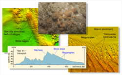
A gridded multibeam bathymetric dataset covers approximately 133.7 square kilometers of sea floor offshore in eastern Long Island Sound. Although originally collected for charting purposes during National Oceanic and Atmospheric Administration hydrographic survey H11997, these acoustic data, and the sea-floor sampling and photography stations subsequently occupied to verify them during USGS cruise 2010-015-FA, are part of an expanding series of studies that provide a fundamental framework for research and resource management (for example, cables, pipelines, and dredging) activities in this major East Coast estuary. Results show the composition and terrain of the seabed and provide information on sediment transport and benthic habitat. Bedrock outcrops, erosional outliers, lag deposits of boulders, scour depressions, and extensive gravel pavements are common in the eastern part of the study area. These features, which result from the near-constant exposure to strong tidal currents, indicate sedimentary environments dominated by processes associated with erosion. Large fields of transverse and barchanoid sand waves in the western part of the study area reflect slightly lower energy levels and sedimentary environments where processes associated with coarse bedload transport prevail. |
Posted March 30, 2011 For additional information contact: Part or all of this report is presented in Portable Document Format (PDF); the latest version of Adobe Reader or similar software is required to view it. Download the latest version of Adobe Reader, free of charge. |
Poppe, L.J., McMullen, K.Y., Ackerman, S.D., Blackwood, D.S., Schaer, J.D., Forrest, M.R., Ostapenko, A.J., and Doran, E.F., 2011, Sea-floor geology and topography offshore in Eastern Long Island Sound: U.S. Geological Survey Open-File Report 2010–1150, DVD-ROM. (Also available at https://pubs.usgs.gov/of/2010/1150.)

![]() U.S. Department of the Interior |
U.S. Geological Survey
U.S. Department of the Interior |
U.S. Geological Survey
[an error occurred while processing this directive]
URL: https://pubsdata.usgs.gov
Page Contact Information: Contact USGS
Page Last Modified: Wednesday, 07-Dec-2016 23:24:32 EST
