U.S. Geological Survey Open-File Report 2012-1038
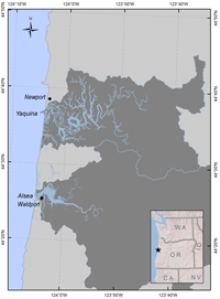
IntroductionWetlands in Oregon estuaries have been altered by past human land uses and will continue to undergo changes owing to future human land use decisions and climate change effects, such as sea-level rise, increased storm frequency and intensity, and changing temperature and precipitation patterns. Human alterations to tidal wetlands in several Oregon estuaries have been well documented through field surveys, aerial photograph interpretation of high resolution imagery, and Light Detection and Ranging (LiDAR) analyses (Brophy, 1999, 2005, 2012). However, some of these data were published as reports (for example, Brophy, 1999) and were not available in a format that could be used for modeling future changes in coastal habitats because of sea-level rise (SLR). In addition, although the National Wetlands Inventory (NWI) data layers had been updated by the U.S. Fish and Wildlife Service in 2010, for the Yaquina and Alsea estuaries, preliminary SLR model runs for the Yaquina estuary by U.S. Geological Survey (USGS) indicated that some important wetlands were possibly miscoded. To improve SLR modeling results and enhance the accuracy and utility of the NWI for resource managers, the USGS provided funding to Green Point Consulting in 2010 to develop enhanced Geographic Information Systems (GIS) products for the Yaquina and Alsea drainage basins with recommended NWI (Cowardin et al. 1979) classification revisions using information from previous studies and expert field knowledge. This report describes the methods used to enhance the NWI data layers and to develop the other GIS products, and summarizes the results of these changes. This report also includes photographs of wetland types and plant species that are common in these estuaries. Links to download the data are located in the data section of this document. Study AreaThe Yaquina estuary is on the central Oregon coast adjacent to the town of Newport at latitude 44.62° N, longitude 124.02° W. The Alsea estuary is approximately 16 mi south of the Yaquina estuary adjacent to the town of Waldport, Oregon (fig. 1). The project study areas include the entire Yaquina River estuary and the entire Alsea River estuary, from the Pacific Ocean to the upstream limit of tidal influence. Instead of the mapped head of tide, as published by the Oregon Department of State Lands (OR DSL) (2007), the study area included all land surfaces within tidal range (based on LiDAR-derived elevations), as described in section, "LiDAR Analysis", even if those land surfaces were upstream of mapped head of tide. This was necessary because field experience has shown that the DSL head of tide mapping is sometimes inaccurate (for example, Brophy, 2012), and because this study included former tidal wetlands behind the tide gates and barriers that constitute the current head of tide in some water bodies.
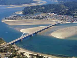
The Yaquina and Alsea estuaries are drowned river mouths with expansive intertidal mud flats near their mouths ( fig. 2 ). Upslope and upstream of the mud flats are the three types of tidal wetlands addressed in this study: emergent tidal wetlands (tidal marsh), scrub-shrub tidal wetlands, and forested tidal wetlands. All three types can occur as either saline or freshwater wetlands. Their corresponding Cowardin et al. classes are shown in table 1. Woody-dominated (scrub-shrub and forested) tidal wetlands are collectively referred to as "tidal swamp". The estuarine and tidally influenced palustrine wetland vegetation in both of these estuaries is species-rich and includes grasses such as Deschampsia cespitosa ( fig. A1 ), Agrostis stolonifera ( fig. A2 ), Hordeum jubatum ( fig. A3 ), and Distichlis spicata; rushes (Juncus spp., figs. A4–A5); sedges such as Carex lyngbyei ( fig. A6 ) and Carex obnupta ( fig. A7 ); and succulent halophytes (Triglochin maritimum, fig. A8 ). Trees and shrubs found in Yaquina and Alsea tidal wetlands include Sitka spruce (Picea sitchensis) ( fig. A9 ) and black twinberry (Lonicera involucrata) ( figs. A10–A11 ). Additional representative landscapes and vegetation present across the study areas can be seen in figures A12–A32 . Further information on Oregon tidal wetland habitats and vegetation can be found in Akins and Jefferson (1973), Jefferson (1975), Eilers (1975), Adamus and others (2005), and Brophy (2007a). Table 1. Common names for tidal wetland types frequently found in the Yaquina and Alsea estuaries, and their corresponding Cowardin et al. (1979) classifications. [Table does not include all possible wetland types]
Like other Oregon estuaries, the Yaquina and Alsea estuaries are subjected to dry summers, during which river influence is low and ocean influence is high; and wet winters, where river influence increases (Brown and Ozretich, 2009). During the summer months, strong upwelling events provide nutrient rich waters to Pacific coast estuaries. Estuaries contribute to coastal ecosystem services by cycling nutrients and providing critical habitat for native plants and animals including marine, anadromous, and resident fish, birds, and invertebrates (Adamus, 2006). Project Goals and ObjectivesThe goals of this project were to enhance the NWI data with expert local and regional knowledge for the Alsea and Yaquina estuaries, to improve the accuracy and utility of these GIS layers for resource management and to improve model results, for potential future wetland habitat distributions due to sea-level rise. To accomplish these goals, the following specific objectives were established:
|
First posted May 10, 2013
For additional information contact: Part or all of this report is presented in Portable Document Format (PDF); the latest version of Adobe Reader or similar software is required to view it. Download the latest version of Adobe Reader, free of charge. |

![]() U.S. Department of the Interior |
U.S. Geological Survey
U.S. Department of the Interior |
U.S. Geological Survey
URL: http://pubsdata.usgs.gov/pubs/of/2012/1038/introduction.html
Page Contact Information: GS Pubs Web Contact
Page Last Modified: Friday, 10-May-2013 12:37:32 EDT